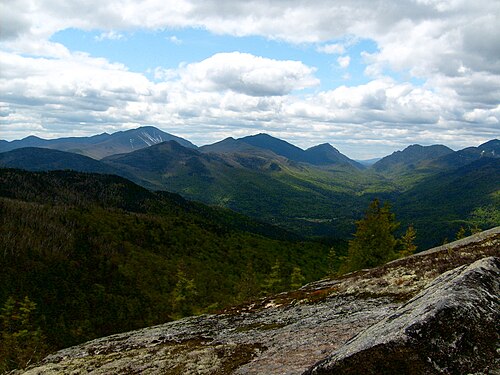
アメリカ北東部のほとんどはアパラチア高地の自然地理学的地域に位置しているが、一部は南のフロリダ南端まで広がる大西洋沿岸平野の一部でもある。沿岸平野にはマサチューセッツ州のケープコッド、ニューヨーク州のロングアイランド、ニュージャージー州の大部分が含まれ、一般的に低く平坦で、砂質土と湿地である。[13]ピードモント山脈やアパラチア山脈を含む高地は、起伏のある丘陵から標高6,000フィート (1,800 m) を超える山頂まで森林が密生し、多くの湖が点在している。[13]北東部の最高峰はニューハンプシャー州のワシントン山で、標高6,288フィート (1,917 m) である。[81]
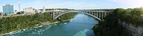
The Rainbow Bridge, connecting New York to Canada nearby Niagara Falls.Bulkeley Bridge (I-84) - Crosses the Connecticut River, connecting Hartford area traffic across the river. The oldest interstate crossing in the US. Opened in 1908.
The Jersey City Terminal, a major rail and ferry connection between New Jersey and New York City.The Cross-Bronx Expressway (I-95) is an urban freeway which was built using slum clearance policies in the 1950s and 1960s. Today it is one of the most congested highways in the nation. It is regarded as a major cause for urban decay in the Bronx.[102]
The Northeast has been a place for many firsts in transportation in the US, from the first commercial railroad in the US in Milton, Massachusetts (Granite Railway), first rapid transit system (MBTA Green Line),[103] the first limited access road was the Bronx River Parkway, opened in 1922,[104] New York is also where the first urban freeway was built in the late-1930s.[105] (FDR Drive) The northeast would also be home to some of the first major freeway revolts in Greenwich Village,[106] and would see the first major highway teardown (Miller Highway) in the 1970s.[107]
Before European settlement, most of the Northeast was loosely connected by Native American trails, some of which would be incorporated into early-European settlement roads and turnpikes. One major early road was the Boston Post Road, connecting New York City and Boston along the Connecticut and Rhode Island coasts.[108] Later these roads would be included in the King's Highway, spanning most of the east coast. Smaller turnpikes would also connect cities across the northeast. These roads would prove essential to moving goods across the English colonies in the 18th century and would later play a large part in the American Revolution.[109]
The region saw a boom in canal-building in the early-19th century, with a major canal being the Erie Canal, opened in 1825, connecting the Great Lakes to the Hudson River and Atlantic Ocean through Western New York.[110] The first railroads would be built in the late-1820s and would explode in mileage in the mid to late 19th century.[111] Places like Philadelphia, New York, Boston, Newark, and Pittsburgh would become large water and rail hubs during the Industrial Revolution and would see tremendous booms in population and use.[112]
Many large rivers in the northeast like the Hudson and Delaware would be slowly crossed with bridges starting in the 1800s, with the first fixed crossing of the Hudson River south of Albany being the Poughkeepsie Railroad Bridge, opened in 1889.[113] The Delair Bridge, which would connect Philadelphia with New Jersey was opened six years later in 1896.[114] The first crossing of the Hudson River into New York City would be the series of Hudson River PATH tunnels, being opened in 1908 and 1909.[115] The first major vehicle tunnel would be the Holland Tunnel, opened up in 1927.[116]
The start of highway construction would be the Bronx River Parkway and Long Island Motor Parkway, both of which started construction in the early-1900s.[117] The rise of Robert Moses in New York would see the construction of many major road bridges and highways crossing the city and metro area. East River Drive (eventually renamed FDR Drive), was built along the corresponding river in Manhattan.[118] The mid-20th century would see the rise of urban and suburban freeways and the decline of passenger and freight rail, with many lesser used tracks being abandoned or torn up during this time.[119] It would also see the original Pennsylvania Station demolished in Midtown Manhattan during the mid-1960s.[120] The construction of the Cross-Bronx Expressway in New York, Central Artery in Boston, and the Vine Street Expressway in Philadelphia tore up many ethnic and minority neighborhoods in the name of urban renewal.[121][122][123][124] Many other highways were proposed during this era, like the Lower Manhattan Expressway and the Inner Belt in Boston, which were not built due to fierce highway revolts and rising costs.[106][124][125] After the major highway revolts and rise of environmental concerns, new highway and interstate projects were mostly cancelled or shortened in the Northeast by the 1990s.
Despite the lack of new major road projects in the Northeast, the region has still continued to grow in population, resulting in the rise of alternative forms of transport like HOV lanes or commuter rails. This has led to the Northeast having one of the highest transit usage percentages in North America, with the Long Island Railroad being the most used commuter rail in the continent.[126] One exception was the Big Dig, a major road project that would tear down the former elevated Central Artery (I-93) and instead tunnel it (and widen). It would also construct a new Charles River bridge and the Ted Williams Tunnel (I-90). This would end up becoming one of the costliest construction projects in the world, costing $21 billion adjusted to 2020 inflation.[127] The former highway's path would become the Rose Kennedy Greenway, a large public park. The Sheridan Expressway (former I-895) was also rebuilt into a boulevard in the late-2010s.[128]Rochester, New York has torn down the Inner Loop due to low traffic and to reunify neighborhoods in downtown and to create developable space.[129]
Culture
One geographer, Wilbur Zelinsky, asserts that the Northeast region lacks a unified cultural identity,[12] but has served as a "culture hearth" for the rest of the nation.[130] Several much smaller geographical regions within the Northeast have distinct cultural identities.[12]
Landmarks
Almost half of the National Historic Landmarks maintained by the National Park Service are located in the Northeastern United States.[131]
Religion
According to a 2009 Gallup poll, the Northeastern states differ from most of the rest of the U.S. in religious affiliation, generally reflecting the descendants of immigration patterns of the late 19th and early 20th centuries, with many Catholics arriving from Ireland, Italy, French Canada - Quebec, Portugal and east-central Europe. Massachusetts, Rhode Island, New York and New Jersey are the only states in the nation where Catholics outnumber Protestants and other Christian denominations. More than 20% of respondents in Maine, New Hampshire, and Vermont declared no religious identity.[132] Compared to other U.S. regions, the Northeast, along with the Pacific Northwest, has had the lowest regular religious service attendance and the fewest people for whom religion is an important part of their daily lives as of 2015.[133]
Sports
The Northeast region is home to numerous professional sports franchises in the "Big Four" leagues (NFL, NBA, NHL and MLB),[134] with more than 100 championships collectively among them.[135]
The region has also been noted for the prevalence of the traditionally Northeastern sports of ice hockey and lacrosse.[136]
Politics
The Northeastern United States tended to vote Republican in federal elections through the first half of the 20th century, but the region has since the 1990s shifted to become the most Democratic region in the nation, along with the West Coast.[73] Results from a 2008 Gallup poll indicated that eight of the top ten Democratic states were located in the region, with every Northeastern state having a Democratic Party affiliation advantage of at least ten points.[137] The following table demonstrates Democratic support in the Northeast as compared to the remainder of the nation.[138]
The following table of United States presidential election results since 1920 illustrates that over the past eight presidential elections, only three Northeastern states supported a Republican candidate. New Hampshire voted for George W. Bush in 2000;[139] Pennsylvania and Maine's 2nd congressional district voted for Donald Trump in 2016;[140] and Maine's 2nd district voted for Trump again in 2020.[141] 2004 is so far the only election in U.S. history in which the winner did not win any northeastern state.[142] Bolded entries indicate that party's candidate also won the general election.
The following table shows the breakdown of party affiliation of governors, attorneys general, state legislative houses and U.S. congressional delegation for the Northeastern states, as of May 2020[update]. (Demographics reflect registration-by-party figures from that state's registered voter statistics.)
^The term "East Coast" is almost exclusively used to refer to the Northeastern megalopolis. As stated in numerous dictionaries and encyclopedias, including both the Oxford English Dictionary and the American Heritage Dictionary, the 'East Coast' primarily refers to the region between Washington D.C. in the south and Boston in the north.[7][8][9] Historically, the term has always connoted the Northeast.
^The U.S. Census Bureau reorganized its administrative units, and its regional offices do not cover the Census regions (the northeasternmost regional office headquartered in New York covers New England, New York, New Jersey, and Puerto Rico).[55]
^Based on U.S. Census Bureau population projections to 2030 (and assuming constant land area) the population density for the South Atlantic division will increase significantly to 294.6/mi2, New England's density will increase to 249.2/mi2 and the East North Central division will increase only slightly to 200.2/mi2. The division with the 5th highest density is projected to be the East South Central division at 111.6/mi2.[92]
^"American FactFinder, GCT-PH1-Population, Housing Units, Area, and Density". U.S. Census Bureau. 2000. Archived from the original on February 12, 2020.
^ a b"Elevations and Distances in the United States". United States Geological Survey. 2001. Archived from the original on October 15, 2011. Retrieved October 24, 2011.
^ a b"Change in Resident Population of the 50 States, the District of Columbia, and Puerto Rico: 1910 to 2020" (PDF). United States Census Bureau. April 26, 2021. Archived (PDF) from the original on April 26, 2021. Retrieved June 13, 2021.
^"Gross Domestic Product (GDP) by State". Archived from the original on July 2, 2018. Retrieved March 9, 2018.
^"East Coast". Archived from the original on August 3, 2022.
^"East Coast". Thefreedictionary.com.
^"East Coast - Definition, Meaning & Synonyms". Vocabulary.com. Retrieved September 30, 2023.
^ a b"GDP by State | U.S. Bureau of Economic Analysis (BEA)". Bea.gov. Retrieved March 5, 2023.
^"Sub-national HDI - Subnational HDI - Table - Global Data Lab". globaldatalab.org. Retrieved March 5, 2023.
^ a b c dHobbs, Joseph John (2009). World Regional Geography. Cengage Learning. p. 647. ISBN 978-0-495-38950-7. Archived from the original on January 26, 2021. Retrieved November 4, 2013.
^Mir Tamim Ansary (2001). Eastern Woodlands Indians. Capstone Classroom. p. 4. ISBN 978-1-58810-451-9.
^Pritzker, Barry (2000). A Native American Encyclopedia: History, Culture, and Peoples. Oxford University Press. p. 398. ISBN 0-19-513877-5.
^ a b"Northeast Region Fact Sheet" (PDF). Archived (PDF) from the original on July 2, 2013. Retrieved July 31, 2013.
^Nash, Gary B. Red, White and Black: The Peoples of Early North America Los Angeles 2015. Chapter 1, p. 8
^ a bArenstam, Peter; Kemp, John; Grace, Catherine O'Neill (2007). Mayflower 1620: A New Look at a Pilgrim Voyage. Washington, D.C.: National Geographic. ISBN 978-0-7922-6276-3. Archived from the original on April 24, 2016. Retrieved October 17, 2015.
^"A Brief History of Cambridge, Massachusetts, USA". Cambridge Historical Commission. Archived from the original on September 30, 2012. Retrieved August 16, 2012.
^Kelly, Martin (September 5, 2019). "Founding of Connecticut Colony". ThoughtCo. Retrieved September 12, 2024.
^ a bKelly, Martin (August 2, 2020). "How Rhode Island Colony Was Founded". ThoughtCo. Retrieved September 12, 2024.
^Barreveld, Drs. Dirk J. (2001). From New Amsterdam to New York: the founding of New York by the Dutch in July 1625. New York: Writers Club Press. ISBN 978-0-595-19890-0.
^ a b c"The Middle Colonies". Radford University. Archived from the original on July 20, 2012. Retrieved August 16, 2012.
^Jenks, Henry Fitch (1880). The Boston Public Latin School. 1635-1880. M. King. Retrieved August 16, 2012.
^"Harvard University Founded". CelebrateBoston.com. Archived from the original on June 6, 2012. Retrieved August 16, 2012.
^Forrest, Tuomi J. "William Penn – Introduction". Archived from the original on December 8, 2013. Retrieved August 16, 2012.
^Munroe, John A (2006). "3. The Lower Counties on The Delaware". History of Delaware (5th, illustrated ed.). University of Delaware Press. p. 45. ISBN 0-87413-947-3. Archived from the original on February 20, 2021. Retrieved November 2, 2020.
^Lurie, Mappen M (2004), Encyclopedia of New Jersey, Rutgers University Press, p. 327, ISBN 0-8135-3325-2.
^Mayo, LS (1921), John Wentworth, Governor of New Hampshire: 1767–1775, Harvard University Press, p. 5.
^Daughan, George C. (2018). Lexington and Concord : the battle heard round the world. New York, NY: W.W. Norton & Company. ISBN 978-0-393-24575-2. OCLC 1089832154.
^Boatner, Mark M. III (1994). Encyclopedia of the American Revolution (3rd ed.). Mechanicsburg, Pa.: Stackpole Books. ISBN 0-8117-0578-1. OCLC 29595553.
^González, Jennifer (November 17, 2015). "On This Day: Congress Moves to Washington, D.C. | In Custodia Legis: Law Librarians of Congress". blogs.loc.gov. Retrieved February 19, 2023.
^Jillson, Calvin C. (2009). American government: political development and institutional change (5th ed.). New York: Routledge. ISBN 978-0-415-99570-2. OCLC 263497894.
^"A Century of Lawmaking for a New Nation: U.S. Congressional Documents and Debates, 1774 - 1875". memory.loc.gov. Retrieved February 19, 2023.
^Berkin, Carol (2017). A Sovereign People: The Crises of the 1790s and the Birth of American Nationalism. New York: Basic Books. ISBN 978-0-465-09493-6. OCLC 961388695. Partial preview a Google Books.
^Buel, Richard (2005). America on the brink: how the political struggle over the war of 1812 almost destroyed the young republic. New York, N.Y.: Palgrave Macmillan. ISBN 1-4039-6238-3. OCLC 55510543.
^Benn, Carl (2002). The War of 1812. Oxford: Osprey. ISBN 1-84176-466-3. OCLC 59463925.
^"Old Slater Mill". National Historic Landmarks Program. Archived from the original on October 7, 2012. Retrieved February 19, 2023.
^"The Industrial Revolution in the United States | Classroom Materials at the Library of Congress | Library of Congress". Library of Congress, Washington, D.C. 20540 USA. Retrieved February 19, 2023.
^ a bJackson, Kenneth T. (1995). The Encyclopedia of New York City. New Haven, Conn. : New York: Yale University Press ; New-York Historical Society. ISBN 978-0-300-05536-8. OCLC 32395903.
^Mueller, Ken S. (2017). "Wolf by the Ears: The Missouri Crisis, 1819–1821 by John R. Van Atta (review)". Journal of the Early Republic. 37 (1): 173–175. doi:10.1353/jer.2017.0011. ISSN 1553-0620. S2CID 151453560.
^"Slavery in Delaware". slavenorth.com. Retrieved February 19, 2023.
^"List of Classified Structures". July 21, 2011. Archived from the original on July 21, 2011. Retrieved February 19, 2023.
^Foner, Eric (2002). Reconstruction: America's unfinished revolution, 1863-1877 (1st Perennial Classics ed.). New York: Perennial Classics. ISBN 0-06-093716-5. OCLC 48074168.
^"The Brooklyn Daily Eagle 09 Dec 1940, page 10". Newspapers.com. Retrieved February 19, 2023.
^"The Strike at Homestead Mill | American Experience | PBS". Pbs.org. Retrieved February 19, 2023.
^"Who Makes It?". 63alfred.com. Retrieved February 19, 2023.
^Sugrue, Thomas J. (2014). The origins of the urban crisis : race and inequality in postwar Detroit. New Jersey: Princeton University Press. ISBN 978-1-4008-5121-8. OCLC 878919151.
^"Sun Belt Growth Shapes Housing's Future | Government > Government Bodies & Offices from AllBusiness.com". June 24, 2008. Archived from the original on June 24, 2008. Retrieved February 19, 2023.
^"Table 7. Connecticut - Race and Hispanic Origin for Selected Large Cities and Other Places: Earliest Census to 1990" (PDF). June 29, 2006. Archived from the original (PDF) on June 29, 2006. Retrieved February 19, 2023.
^"NEW YORK - Water, fire, destruction: NYC after the superstorm - Nation - TheState.com". November 1, 2012. Archived from the original on November 1, 2012. Retrieved February 28, 2023.
^Newport, Frank. "State of the States: Importance of Religion". Gallup. Archived from the original on August 17, 2012. Retrieved August 17, 2012.
^"Mississippians Go to Church the Most; Vermonters, Least". Gallup.com. February 17, 2010. Archived from the original on September 27, 2013. Retrieved March 17, 2012.
^"2013 Regions of the US Census Bureau" (PDF). Census Bureau. Archived (PDF) from the original on October 14, 2013. Retrieved July 22, 2013.
^Geographic Areas Reference Manual. U.S. Census Bureau. 1994. pp. 6–1. Archived from the original on June 24, 2016. Retrieved July 4, 2013.
^Seymour Sudman & Norman M. Bradburn (1982). Asking Questions: Practical Guide to Questionnaire Design. Jossey-Bass. p. 205. ISBN 978-0-87589-546-8. Archived from the original on May 15, 2016. Retrieved October 17, 2015. The most widely used regional definitions follow those of the U.S. Bureau of the Census.
^Dale M. Lewison (1997). Retailing. Prentice Hall. p. 384. ISBN 978-0-13-461427-4. Archived from the original on December 15, 2019. Retrieved October 17, 2015. Perhaps the most widely used regional classification system is one developed by the U.S. Census Bureau.
^Pamela Goyan Kittler; Kathryn P. Sucher (2008). Food and Culture. Cengage Learning. p. 475. ISBN 978-0-495-11541-0. Archived from the original on January 26, 2021. Retrieved November 2, 2020. (M)ost demographic and food consumption data are presented in this four-region format.
^Proceedings of the National Geographic Areas Conference: putting it together for 1990. U.S. Census Bureau. 1984. p. 161. Archived from the original on April 26, 2016. Retrieved October 17, 2015.
^ a b"Six: Statistical Groupings of States and Counties". Geographic Areas Reference Manual (PDF). U.S. Census Bureau. November 1994. Archived (PDF) from the original on April 19, 2013. Retrieved July 31, 2013.
^Verne Thompson, ed. (2010). Encyclopedia of Associations: Regional, State, and Local Organizations: Northeastern States. Vol. (Vol. 2: Northeastern States) (22 ed.). Gale.
^The New York Times Guide to Essential Knowledge: A Desk Reference for the Curious Mind. Macmillan. 2011. p. 630. ISBN 978-1-4299-5085-5.
^Kelley, Mary Lebreck & Virginia Macken Fitzsimons (2000). Understanding Cultural Diversity: Culture, Curriculum, and Community in Nursing. Jones & Bartlett Learning. p. 220. ISBN 978-0-7637-1106-1.
^"Mason-Dixon Line". Encyclopedia Britannica. Archived from the original on May 12, 2020. Retrieved May 26, 2020.
^"Overview – AAG". aag.org. Archived from the original on March 11, 2019. Retrieved May 10, 2014.
^"Geological Society of America – Northeastern Section". geosociety.org. Archived from the original on November 23, 2019. Retrieved August 29, 2019.
^"Safety: ORA District and Headquarters Recall Coordinators". U.S. Food and Drug Administration. Archived from the original on August 19, 2013. Retrieved July 24, 2013.
^"About The Council". Department of Defense Northeast Regional Council. Archived from the original on September 23, 2013. Retrieved September 21, 2013.
^John C. Hudson (2002). Across This Land: A Regional Geography of the United States and Canada. JHU Press. p. 81 ff. ISBN 0-8018-6567-0.
^Thomas F. McIlwraith; Edward K. Muller (2001). North America: The Historical Geography of a Changing Continent. Rowman & Littlefield. p. 190. ISBN 0-7425-0019-5.
^ a bShelley, Fred M., ed. (1996). Political Geography of the United States. Guilford Press. ISBN 1-57230-048-5.
^ a b"Region I Jurisdiction". Nuclear Regulatory Commission. Archived from the original on September 10, 2013. Retrieved July 25, 2013.
^ a bDaniel P. Bigelow & Allison Borchers (2012). "Major Uses of Land in the United States" (PDF). USDA's Economic Research Service. Archived (PDF) from the original on November 29, 2021. Retrieved August 5, 2021.
^Barron, Eric (2001). "Chapter 4: Potential Consequences of Climate Variability and Change for the Northeastern United States". In National Assessment Synthesis Team, U.S. Global Change Research Program (ed.). Climate Change Impacts on the United States: The Potential Consequences of Climate Variability and Change. Cambridge University Press. ISBN 0-521-00075-0. Retrieved March 15, 2010.
^"National Park Service Regions" (PDF). United States Department of the Interior. Archived (PDF) from the original on September 28, 2013. Retrieved February 25, 2013.
^ a b"Regional Climate Trends and Scenarios for the U.S. National Climate Assessment" (PDF). National Oceanic and Atmospheric Administration. January 2013. Archived (PDF) from the original on April 29, 2013. Retrieved July 19, 2013.
^"Climate Summaries - Northeast Overview - January 2013". Archived from the original on September 29, 2013. Retrieved July 19, 2013.
^"Climate Summaries - Northeast Overview - July 2012". Archived from the original on September 29, 2013. Retrieved July 19, 2013.
^"2022, Release Tables: Resident Population by State, Annual | FRED | St. Louis Fed". fred.stlouisfed.org. Retrieved February 28, 2023.
^"Alabama – Race and Hispanic Origin: 1800 to 1990" (PDF). November 21, 2014. Archived from the original (PDF) on November 21, 2014. Retrieved February 28, 2023.
^Frank Hobbs & Nicole Stoops (2002). Demographic Trends in the 20th Century. U.S. Department of Commerce, Economics and Statistics Administration, U.S. Census Bureau. p. 18. ISBN 978-0-16-067633-8. Archived from the original on July 5, 2014. Retrieved July 12, 2013.
^"Explore Census Data". data.census.gov. Retrieved February 28, 2023.
^"Explore Census Data". data.census.gov. Retrieved February 28, 2023.
^"Explore Census Data". data.census.gov. Retrieved February 28, 2023.
^"Explore Census Data". data.census.gov. Retrieved February 28, 2023.
^ a b"2005 Interim State Population Projections - People and Households - U.S. Census Bureau". census.gov. Archived from the original on May 21, 2017. Retrieved December 9, 2017.
^"2020 Population and Housing State Data". Census.gov. Retrieved February 28, 2023.
^"StackPath". Masstransitmag.com. January 21, 2020. Retrieved February 13, 2023.
^"Calendar Year 2011 Primary Airports" (PDF). Washington: Federal Aviation Administration. Archived (PDF) from the original on September 24, 2015. Retrieved November 9, 2014.
^"ATCSCC Flight Delay Information – Northeastern States". Washington: Federal Aviation Administration. Archived from the original on March 21, 2021. Retrieved November 17, 2014.
^"Airports Regional & District/Development Offices". faa.gov. Archived from the original on November 21, 2014. Retrieved November 17, 2014.
^"RITA Stats". Washington: U.S. Department of Transportation. November 2022. Retrieved February 12, 2023.
^"CY 2021 Commercial Service Airports, Rank Order" (PDF). Federal Aviation Administration. September 16, 2022. Archived (PDF) from the original on February 3, 2023. Retrieved February 3, 2023.
^"Table 1: Main Routes of the Dwight D. Eisenhower National System Of Interstate and Defense Highways as of December 31, 2018". FHWA Route Log and Finder List. Washington: Federal Highway Administration. May 6, 2019. Retrieved April 21, 2021.
^"BBC Four - Citizen Jane: Battle for the City". London: BBC. Retrieved February 13, 2023.
^Cudahy, Brian J. (1972). Change at Park Street Under; the story of Boston's subways. Brattleboro, Vt.: S. Greene Press. ISBN 978-0-8289-0173-4.
^"Bronx River Parkway". Nycroads.com. Retrieved February 13, 2023.
^"EAST DRIVE LINK OPENS; Southbound Lanes Ready Today From 92d to 122d Streets". The New York Times. October 31, 1936. ISSN 0362-4331. Retrieved February 13, 2023.
^ a bFlint, Anthony (2009). Wrestling with Moses: how Jane Jacobs took on New York's master builder and transformed the American city. New York: Random House. ISBN 978-1-4000-6674-2.
^Levine, Richard (January 6, 1989). "Highway's Demise: Nightmare for Drivers". The New York Times. ISSN 0362-4331. Retrieved February 13, 2023.
^Clark, George Larkin (1914). A History of Connecticut: Its People and Institutions. G.P. Putnam's Sons. ISBN 978-0-7222-4982-6.
^"Washington-Rochambeau Revolutionary Route National Historic Trail (U.S. National Park Service)". Nps.gov. Retrieved February 13, 2023.
^Maag, Christopher (November 3, 2008). "Hints of Comeback for Nation's First Superhighway". The New York Times. ISSN 0362-4331. Retrieved February 13, 2023.
^Military enterprise and technological change: perspectives on the American experience. Merritt Roe Smith. Cambridge, Mass.: MIT Press. 1985. ISBN 0-262-19239-X. OCLC 11676079.{{cite book}}: CS1 maint: others (link)
^Van Oss, Salomon Frederik (1893). American railroads and British investors. University of California Libraries. London, E. Wilson & Co.
^"Poughkeepsie-Highland Bridge Historical Marker". Hmdb.org. Retrieved February 13, 2023.
^"Delaware River bridge, April 18, 1896". Lewisburg Chronicle. April 18, 1896. p. 1. Retrieved February 13, 2023.
^"TROLLEY TUNNEL OPEN TO JERSEY; President Turns On Power for First Official Train Between This City and Hoboken. REGULAR SERVICE STARTS Passenger Trains Between the Two Cities Begin Running at Midnight. EXERCISES OVER THE RIVER Govs. Hughes and Fort Make Congratulatory Addresses – Dinner at Sherry's in the Evening". The New York Times. February 26, 1908. ISSN 0362-4331. Retrieved February 13, 2023.
^"GREAT CROWD TREKS INTO HOLLAND TUBES AFTER GALA OPENING; Thousands Pour In as Coolidge on Yacht Turns Switch With Golden Key. AUTOS START AT MIDNIGHT Hundreds of Honking Cars Rush Through Tunnels From New York and Jersey Sides. OFFICIALS HAIL THE EVENT Governor Smith, Governor Moore, Edwards, Edge and Others Extol Engineering Triumph. Impressive Ceremonies in Two States Mark Opening of Holland Tunnel SCENES AT THE OPENING OF THE HOLLAND TUNNEL UNDER THE HUDSON". The New York Times. November 13, 1927. ISSN 0362-4331. Retrieved February 13, 2023.
^Patton, Phil (October 9, 2008). "A 100-Year-Old Dream: A Road Just for Cars". The New York Times. ISSN 0362-4331. Retrieved February 13, 2023.
^"FDR Drive". Nycroads.com. Retrieved February 13, 2023.
^Straub, Peter (1999). Mister X: a novel (1 ed.). New York: Random House. ISBN 0-679-40138-5. OCLC 40150621.
^Huxtable, Ada Louise (May 5, 1963). "ARCHITECTURE: HOW TO KILL A CITY; Ours Is an Impoverished Society That Cannot Pay for the Amenities Joker Impotent Authority Radical-Picturesque For the Worse". The New York Times. ISSN 0362-4331. Retrieved February 13, 2023.
^Glennon, Patrick (February 22, 2018). "How Chinatown rallied when development threatened to divide the neighborhood | Philly History". inquirer.com. Retrieved February 13, 2023.
^"Boston's 'Big Dig' opens to public". NBC News. December 21, 2003. Retrieved February 13, 2023.
^"TENANT RELOCATION PART OF ROAD PLAN; Estimate Board Approves Conditionally Aid to Those WhoseHouses Will Be Razed". The New York Times. February 1, 1946. ISSN 0362-4331. Retrieved February 13, 2023.
^ a bCaro, Robert A. (1975). The power broker: Robert Moses and the fall of New York. New York: Vintage Books. ISBN 0-394-72024-5. OCLC 1631862.
^"Inner Belt Expressway (I-695 and I-95)". Bostonroads.com. Retrieved February 13, 2023.
^"PUBLIC TRANSPORTATION RIDERSHIP REPORT Third Quarter 2022" (PDF). American Public Transportation Association. November 22, 2022. Retrieved February 13, 2023.
^"Governor seeks to take control of Big Dig inspections - Boston.com". March 11, 2007. Archived from the original on March 11, 2007. Retrieved February 13, 2023.
^Office, Photo Courtesy of Governor's (December 20, 2019). "Sheridan Expressway's removal project is completed – Bronx Times". Bxtimes.com. Retrieved February 13, 2023.
^Popovich, Nadja; Williams, Josh; Lu, Denise (May 27, 2021). "Can Removing Highways Fix America's Cities?". The New York Times. ISSN 0362-4331. Retrieved February 13, 2023.
^Zelinsky, Wilbur (December 1955). "Some Problems in the Distribution of Generic Terms in the Place-Names of the Northeastern United States". Annals of the Association of American Geographers. 45 (4): 319. doi:10.1111/j.1467-8306.1955.tb01491.x.
^"Northeast Region – History & Culture". Archived from the original on July 22, 2013. Retrieved July 20, 2013.
^"Religious Identity: States Differ Widely". August 7, 2009. Archived from the original on September 15, 2017. Retrieved September 25, 2013.
^Twenge, Jean M. (2015). "Generational and Time Period Differences in American Adolescents' Religious Orientation, 1966–2014". PLOS ONE. 10 (5): e0121454. Bibcode:2015PLoSO..1021454T. doi:10.1371/journal.pone.0121454. PMC4427319. PMID 25962174.
^"All Cities Are Not Created Equal". Archived from the original on September 29, 2013. Retrieved September 25, 2013.
^"The Northeast Region". Archived from the original on September 29, 2013. Retrieved September 25, 2013.
^Kirsch, George B.; Othello Harris; Claire Elaine Nolte, eds. (2000). Encyclopedia of Ethnicity and Sports in the United States. Greenwood Publishing Group. ISBN 0-313-29911-0.
^"State of the States: Political Party Affiliation". January 28, 2009. Archived from the original on September 27, 2013. Retrieved September 25, 2013.
^Reiter, Howard L. & Jeffrey M. Stonecash (2011). Counter Realignment: Political Change in the Northeastern United States. Cambridge University Press. ISBN 978-1-139-49313-0.
^"2000 Electoral College Results". National Archives. November 5, 2019. Retrieved August 25, 2024.
^"2016 Electoral College Results". National Archives. November 5, 2019. Retrieved August 25, 2024.
^"2020 Electoral College Results". National Archives. November 5, 2019. Retrieved August 25, 2024.



.jpg/500px-Shoreline_between_Gorham_Mountain_trailhead_and_Sand_Beach_(6598fb47-208e-4940-a5fa-8f8b000b14ee).jpg)


.jpg/500px-The_Harmsworth_atlas_and_Gazetter_1908_(135851517).jpg)


 ニューヨーク州ニューヨーク市は、北東部とアメリカの両方で最も人口の多い都市です。2020年の人口は8,804,190人でした。その都市圏の人口は20,140,470人です。 [93]
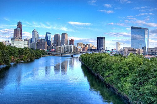 ペンシルベニア州フィラデルフィアは、北東部で2番目に人口が多く、国内では6番目に人口が多い都市です。2020年の人口は1,603,797人でした。都市圏の人口は6,228,601人でした。
 マサチューセッツ州ボストンは北東部で3番目に大きい都市であり、国内では24番目に大きい都市です。2020年の人口は675,647人でした。都市圏の人口は4,941,632人でした。
 ニュージャージー州ニューアークは、北東部で4番目に大きい都市であり、米国では66番目に大きい都市です。2020年の人口は311,549人でした。その都市圏はニューヨーク地域と結合されています。
 ペンシルベニア州ピッツバーグは、北東部で 5 番目、国内で 68 番目に大きい都市です。ピッツバーグは北東部の西の辺境にあり、オハイオ州との国境から車ですぐの距離にあり、北東部と中西部の移行地点として広く知られています。2020 年の人口は 302,971 人でした。都市圏の人口は 2,370,930 人です。
 ニュージャージー州ジャージーシティは、北東部で6番目、国内で75番目に大きい都市です。2020年の人口は292,449人でした。ニューヨーク市からハドソン川を挟んで真向かいに位置しています。
 ニューヨーク州バッファローは、北東部で7番目に大きい都市であり、米国では78番目に大きい都市です。2020年の人口は278,349人でした。都市圏の人口は1,166,902人でした。
 ニューヨーク州ヨンカーズは、北東部で8番目に大きい都市であり、米国で111番目に大きい都市です。2020年の人口は211,569人でした。南はニューヨーク市のブロンクス区と接しています。
 ニューヨーク州ロチェスターは、北東部で9番目に大きい都市であり、米国で112番目に大きい都市です。2020年の人口は211,328人でした。ロチェスター都市圏の人口は1,090,135人です。
 マサチューセッツ州ウースターは、北東部で10番目に大きい都市であり、米国で114番目に大きい都市です。 2020年の国勢調査では、人口は206,518人でした。グレーターボストンの端にある都市であり、そのメトロはグレーターボストンと統合されています。
_(cropped).jpg/500px-Duquesne_Incline_(50076338942)_(cropped).jpg)
.jpg/500px-View_of_Yonkers_from_the_New_Jersey_Palisades_(2).jpg)




_crop.jpg/500px-August_4,_2011_beautiful_Boston_vista_(6012618162)_crop.jpg)


