
Loading article…
| 大西洋 | |
|---|---|
 | |
| 座標 | 北緯0度 西経25度 / 北緯0度 西経25度 / 0; -25 [1] |
| 流域 国 | 国境を接する国(流域ではない)、港湾の一覧 |
| 表面積 | 85,133,000 km 2 (32,870,000 平方マイル) [2] 北大西洋: 41,490,000 km 2 (16,020,000 平方マイル)、 南大西洋 40,270,000 km 2 (15,550,000 平方マイル) [3] |
| 平均深度 | 3,646メートル(11,962フィート)[3] |
| 最大深度 | プエルトリコ海溝 8,376メートル(27,480フィート)[4] |
| 水量 | 310,410,900 km 3 (74,471,500 立方マイル) [3] |
| 海岸長1 | 111,866 km (69,510 mi) 縁海を含む[1] |
| 島々 | 島の一覧 |
| 塹壕 | プエルトリコ;サウスサンドイッチ;ロマンシュ |
| 集落 | リスト |
| 1海岸長は明確に定義された尺度ではありません。 | |
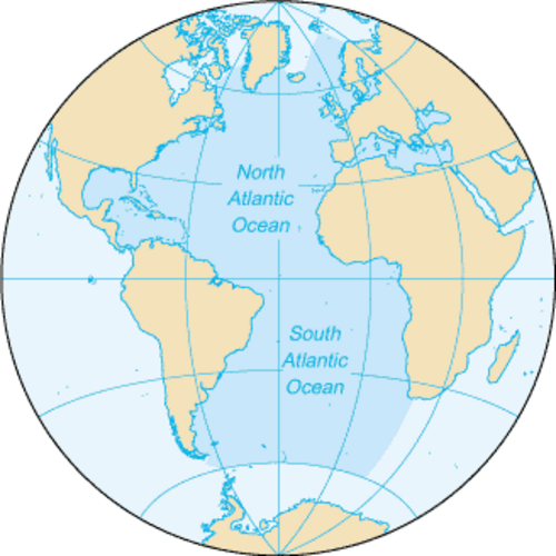
大西洋は世界の5つの海洋区分の中で2番目に大きく、面積は約85,133,000 km 2 (32,870,000平方マイル)です。[2]大西洋は地球の表面積の約17% 、水面面積の約24%を占めています。大航海時代には、大西洋はアメリカ大陸の新世界(北アメリカと南アメリカ) とアフロユーラシアの旧世界(アフリカ、アジア、ヨーロッパ) を隔てる海域として知られていました。
大西洋は、アフロ・ユーラシアをアメリカ大陸から分離させることで、人類社会の発展、グローバリゼーション、そして多くの国の歴史において中心的な役割を果たしてきました。大西洋を横断した最初の人類はノルウェー人として知られていますが、最も影響力があったのは 1492 年のクリストファー・コロンブスの探検でした。コロンブスの探検は、ヨーロッパ列強、特にポルトガル、スペイン、フランス、イギリスによるアメリカ大陸の探検と植民地化の時代の到来を告げました。16 世紀から 19 世紀にかけて、大西洋は同名の奴隷貿易とコロンブス交換の中心地であり、時折海戦の舞台となりました。このような海戦、および米国やブラジルなどの地域のアメリカ大国からの貿易の拡大は、20 世紀初頭に増加しました。現在、大西洋で大きな軍事紛争は発生していませんが、[いつ? ]海洋は依然として世界中の貿易の中心的な要素です。
大西洋は、東はヨーロッパとアフリカ、西はアメリカ大陸の間を縦に伸びる細長いS字型の海盆を占めています。相互につながった世界の海の一部として、北は北極海、南西は太平洋、南東はインド洋、南は南極海につながっています。他の定義では、大西洋は南に南極大陸まで伸びていると説明されています。大西洋は赤道によって北大西洋と南大西洋の2つの部分に分割されています。[5]
地名学

「大西洋」の海についての最も古い既知の言及は、紀元前6世紀半ば頃のステシコロス(Sch. AR 1. 211)によるものです: [6] Atlantikôi pelágei(古代ギリシア語:Ἀτλαντικῷ πελάγει、「大西洋」、語源は「アトラス海」)および紀元前450年頃のヘロドトスの『歴史』(Hdt. 1.202.4)におけるAtlantis thalassa(古代ギリシア語:Ἀτλαντὶς θάλασσα、「アトラス海」または「大西洋」[7])という記述があります。ここでの名称は「ヘラクレスの柱の向こうの海」を指し、すべての陸地を取り囲む海の一部であると言われています。[8]これらの用法では、この名前はギリシャ神話の巨人アトラスを指しており、アトラスは天を支え、後に中世の地図の口絵に登場し、現代の地図帳にもその名前を貸しています。[9]一方、初期のギリシャの船乗りや、イリアスやオデュッセイアなどの古代ギリシャ神話の文学では、このすべてを包み込む海は、世界を囲む巨大な川であるオケアノスとして知られていました。これは、ギリシャ人によく知られた閉鎖された海、つまり地中海や黒海とは対照的です。[10]対照的に、「大西洋」という用語は、もともとモロッコのアトラス山脈とジブラルタル海峡と西アフリカ沿岸の海を指していました。 [9]
古代エチオピアに由来する「エチオピア海」という用語は、19世紀半ばまで南大西洋に適用されていました。[11]大航海時代、大西洋はイギリスの地図製作者にはグレートウェスタンオーシャンとしても知られていました。[12]
池は、イギリス人とアメリカ人が北大西洋を指してよく使う言葉で、減数分裂の一種、または皮肉な控えめな表現として使われる。この言葉は、海そのものについて議論するのではなく、「池のこちら側」や「池の向こう側」、あるいは「池の向こう側」の出来事や状況について言及するときに使われることが多い。[13]この言葉は1640年にさかのぼり、チャールズ1世の治世中に出版されたパンフレットに初めて印刷物として登場し、1869年にネヘミア・ウォリントンの『チャールズ1世の治世に主に起きた出来事に関する歴史的記録』に再録された。その中で、チャールズ1世の国務長官フランシス・ウィンドバンクは大西洋を指して「大きな池」という言葉を使用している。[14] [15] [16]
範囲とデータ
国際水路機関(IHO)は1953年に海洋と海の境界を定義しましたが[17] 、これらの定義の一部はそれ以降改訂されており、 CIAワールドファクトブックなど、さまざまな当局、機関、国によって認められていない定義もあります。それに応じて、海洋と海の範囲と数は異なります。
大西洋は、西側で南北アメリカ大陸と接しています。デンマーク海峡、グリーンランド海、ノルウェー海、バレンツ海を経て北極海とつながっています。東側では、大西洋の境界はヨーロッパ、ジブラルタル海峡(ここで地中海 (縁海)とつながり 、さらに黒海とつながり、どちらもアジアに接しています)とアフリカです。
南東部では、大西洋がインド洋に合流する。アガラス岬から南に伸びる東経20度の子午線がその境界を定めている。1953年の定義では南は南極大陸まで伸びているが、その後の地図では南極海によって60度の緯度で区切られている。 [17]
大西洋には、数多くの湾や海が入り組んだ不規則な海岸線がある。これには、バルト海、黒海、カリブ海、デービス海峡、デンマーク海峡、ドレーク海峡の一部、メキシコ湾、ラブラドル海、地中海、北海、ノルウェー海、スコシア海のほぼ全域、その他の支流水域が含まれる。[1]これらの縁海を含めると、大西洋の海岸線は111,866 km (69,510 mi) となり、太平洋の135,663 km (84,297 mi) と比べて長くなる。[1] [18]
大西洋は、縁海を含めると、面積が 106,460,000 km 2 (41,100,000 平方マイル) で世界の海洋の 23.5% を占め、体積は 310,410,900 km 3 (74,471,500 立方マイル) で地球の海洋総体積の 23.3% を占めます。縁海を除くと、大西洋は 81,760,000 km 2 (31,570,000 平方マイル) の面積を占め、体積は 305,811,900 km 3 (73,368,200 立方マイル) です。北大西洋は41,490,000 km 2 (16,020,000平方マイル) (11.5%)、南大西洋は40,270,000 km 2 (15,550,000平方マイル) (11.1%) を占める。[3]平均深度は3,646 m (11,962 フィート) で、最大深度はプエルトリコ海溝のミルウォーキー海淵で8,376 m (27,480 フィート) である。[19] [20]
大西洋最大の海
上位の大きな海: [21] [22] [23]
- サルガッソー海 – 350万km2
- カリブ海 – 275万4千km2
- 地中海 – 251万km2
- ギニア湾 – 235万km2
- メキシコ湾 – 155万km2
- ノルウェー海 – 138万3000 km 2
- グリーンランド海 – 120万5000 km 2
- アルゼンチン海 – 100万km2
- ラブラドル海 – 841,000 km 2
- イルミンガー海 – 780,000 km 2
- バフィン湾 – 689,000 km 2
- 北海 – 575,000 km 2
- 黒海 – 436,000 km 2
- バルト海 – 377,000 km 2
- リビア海 – 350,000 km 2
- レヴァント海 – 320,000 km 2
- ケルト海 – 300,000 km 2
- ティレニア海 – 275,000 km 2
- セントローレンス湾 – 226,000 km 2
- ビスケー湾 – 223,000 km 2
- エーゲ海 – 214,000 km 2
- イオニア海 – 169,000 km 2
- バレアレス海 – 150,000 km 2
- アドリア海 – 138,000 km 2
- ボスニア湾 – 116,300 km 2
- クレタ海 – 95,000 km 2
- メイン湾 – 93,000 km 2
- リグリア海 – 80,000 km 2
- イギリス海峡 – 75,000 km 2
- ジェームズ湾 – 68,300 km 2
- ボスニア海 – 66,000 km 2
- シドラ湾 – 57,000 km 2
- ヘブリディーズ海 – 47,000 km 2
- アイリッシュ海 – 46,000 km 2
- アゾフ海 – 39,000 km 2
- ボスニア湾 – 36,800 km 2
- ベネズエラ湾 – 17,840 km 2
- カンペチェ湾 – 16,000 km 2
- リオン湾 – 15,000 km 2
- マルマラ海 – 11,350 km 2
- ワッデン海 – 10,000 km 2
- 群島海域 – 8,300 km 2
水深測量
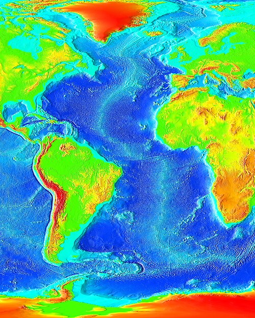
大西洋の水深は、大西洋中央海嶺(MAR)と呼ばれる海底山脈によって支配されている。この海嶺は、北緯87度、つまり北極の南300km(190マイル)から南緯54度の亜南極ブーベ島まで伸びている。[24]大西洋の水深を調査する遠征には、チャレンジャー号遠征やドイツのメテオ号遠征などがある。2001年現在、コロンビア大学のラモント・ドハティ地球観測所と米国海軍水路部が海洋の研究を行っている。[25][update]
大西洋中央海嶺
MARは大西洋を縦に2つに分割し、それぞれの半分には二次的な横方向の尾根によって区切られた一連の盆地がある。MARはほとんどの部分で水深2,000メートル(6,600フィート)を超えるが、赤道近くのロマンシュ海溝と北緯53度のギブス断層帯の2か所でより大きなトランスフォーム断層によって分断されている。MARは底層水の障壁となっているが、この2つのトランスフォーム断層では深層水の流れが一方から他方へ流れることができる。[26]
MARは周囲の海底より2~3 km(1.2~1.9マイル)隆起しており、その地溝帯は北大西洋の北米プレートとユーラシアプレート、南大西洋の南米プレートとアフリカプレートの分岐境界となっている。MARは、アイスランドのエイヤフィヤトラヨークトルに玄武岩質火山を、海底に枕状溶岩を生み出している。 [27]ほとんどの場所で、尾根の頂点の水深は2,700 m(1,500ファゾム、8,900 フィート)未満であるが、尾根の底はその3倍の深さである。[28]
MARは2つの垂直な尾根によって交差している。アゾレス・ジブラルタルトランスフォーム断層は、ヌビアプレートとユーラシアプレートの境界であり、北緯40度付近のアゾレスマイクロプレートの両側にあるアゾレス三重会合点でMARと交差している。[29]北米プレートと南米プレートの間の、はるかに曖昧で名前のない境界は、15-20断裂帯の近くまたはそのすぐ北、およそ北緯16度でMARと交差している。[30]
1870 年代、チャレンジャー号の探検隊は、現在では大西洋中央海嶺として知られている地域の一部を発見しました。
平均して水面下1,900ファゾム(3,500メートル、11,400フィート)の高さまで隆起した尾根が、フェアウェル岬(おそらく少なくともゴフ島までは南)から子午線方向に北大西洋と南大西洋の盆地を横切り、おおよそ旧世界と新世界の海岸の輪郭に沿っている。[31]
海嶺の残りの部分は、1920年代にドイツのメテオール探検隊が音響探査装置を使って発見しました。[32] 1950年代のMARの探査により、海底拡大とプレートテクトニクスが一般的に受け入れられるようになりました。[24]
MARの大部分は水中を流れているが、地表に達した場所では火山島を形成している。これらのうち9つは地質学的価値により世界遺産に指定されているが、そのうち4つは文化と自然の観点から「顕著な普遍的価値」があるとされている。シンクヴェトリル(アイスランド)、ピコ島のブドウ園文化の景観(ポルトガル)、ゴフ諸島とイナクシブル諸島(イギリス)、ブラジル大西洋諸島:フェルナンド・デ・ノローニャ島とアトル・ダス・ロカス保護区(ブラジル)である。[24]
海底
大西洋の大陸棚は、ニューファンドランド、南米最南端、北東ヨーロッパ沖に広がっている。西大西洋では、ブレイク海台やバミューダ海嶺など、炭酸塩岩の台地が広い範囲を占めている。大西洋は、西大西洋のプエルトリコ海溝(最大深度 8,376 メートル、27,480 フィート)や南大西洋のサウスサンドイッチ海溝(8,264 メートル、27,113 フィート)など、活発な境界が深い海溝を形成する数か所を除いて、受動的境界に囲まれている。北アメリカ北東部、西ヨーロッパ、北西アフリカ沖には、数多くの海底峡谷がある。これらの峡谷のいくつかは、大陸棚に沿って延び、深海溝として深海平原のさらに奥まで続いている。[26]
1922年、地図作成と海洋学における歴史的な瞬間が訪れた。USSスチュワートは海軍のソニック深度計を使用して、大西洋の海底の連続地図を描いた。ソナーの考え方は船からパルスを送信し、それが海底で跳ね返って船に戻ってくるという単純なものなので、推測する必要はほとんどなかった。[33]深海底は、ところどころに深海底平野、海溝、海山、盆地、台地、峡谷、およびいくつかのギヨがあるものの、かなり平坦であると考えられている。大陸の縁に沿ったさまざまな棚が海底地形の約11%を占め、大陸の隆起を横切る深い水路はほとんどない。
北緯60度から南緯60度までの平均深度は3,730メートル(12,240フィート)で、世界の海洋の平均に近い。最深部は4,000~5,000メートル(13,000~16,000フィート)である。[26]
南大西洋では、ウォルビス海嶺とリオグランデ海嶺が海流の障壁を形成しています。ローレンシャン海峡はカナダ東海岸沖にあります。
水の特性


表面水温は緯度、海流、季節によって変化し、太陽エネルギーの緯度分布を反映し、-2℃(28℉)以下から30℃(86℉)以上までの範囲である。最高気温は赤道の北で発生し、最低気温は極地で見られる。中緯度では気温の変動が最大となり、値は7~8℃(13~14℉)変化することがある。[25]
ラブラドル海、デンマーク海峡、バルト海では、10月から6月にかけて表面が海氷で覆われることが多い。 [25] [検証に失敗した]
コリオリの力により、北大西洋の水は時計回りに循環するが、南大西洋の水は反時計回りに循環する。大西洋の南潮は半日周期で、つまり24時間ごとに2回の満潮が発生する。北緯40度以上の緯度では、北大西洋振動と呼ばれる東西振動が発生する。[25]
塩分
平均すると、大西洋は最も塩分濃度の高い主要な海洋です。外洋の表層水の塩分濃度は質量で33~37パーツパーサウザンド(3.3~3.7%)の範囲で、緯度と季節によって異なります。蒸発、降水量、河川流入量、海氷融解が表層塩分濃度に影響します。塩分濃度が最も低いのは赤道のすぐ北(熱帯性降雨量が多いため)ですが、一般的に最も低いのは高緯度と大きな河川が流入する海岸沿いです。塩分濃度が最大になるのは、降雨量が少なく蒸発量が多い亜熱帯地域の北緯25度と南緯25度付近です。 [25]
大西洋の熱塩循環の基盤となっている大西洋の高表面塩分濃度は、2つのプロセスによって維持されている。1つは塩分を多く含むインド洋の海水を南大西洋に運ぶアガラス漏出/リング、もう1つは亜熱帯大西洋の海水を蒸発させて太平洋に輸出する「大気橋」である。[34]
水塊
大西洋は、温度と塩分濃度が異なる4つの主要な上層水塊から構成されています。北大西洋最北端にある大西洋亜寒帯上層水は、亜寒帯中層水と北大西洋中層水の水源です。北大西洋中央水は、西部がメキシコ湾流の影響を強く受け、上層がより淡水の下層の亜寒帯中層水に近いため、東部と西部の北大西洋中央水に分けられます。東部の水は地中海水に近いため、塩分濃度が高くなります。北大西洋中央水は、北緯15度で南大西洋中央水に流れ込みます。[36]
中層水は5つあり、そのうち4つは亜極緯度で形成された低塩分水で、1つは蒸発によって形成された高塩分水である。北極中層水は北から流れ、グリーンランド・スコットランド・シルの南にある北大西洋深層水の水源となる。この2つの中層水は、西部と東部の海盆で塩分濃度が異なる。北大西洋の塩分濃度の幅広い範囲は、北部亜熱帯環流の非対称性と、ラブラドル海、ノルウェー・グリーンランド海、地中海、南大西洋中層水など、さまざまな水源からの多数の寄与によって引き起こされている。[36]
北大西洋深層水(NADW)は、4つの水塊の複合体で、そのうち2つは外洋の深層対流によって形成され、古典海水とラブラドル海上部の海水であり、残りの2つはグリーンランド・アイスランド・スコットランドの岩床を横切る高密度水の流入によって形成され、デンマーク海峡とアイスランド・スコットランドの越流水である。地球を横切る経路に沿って、NADWの構成は他の水塊、特に南極底水と地中海の越流水の影響を受ける。[37] NADWは、ヨーロッパの異常な温暖気候の原因となっている北大西洋北部への暖かい浅い水の流れによって供給されている。NADWの形成の変化は、過去に地球規模の気候変動に関連していた。人造物質が環境に導入されて以来、1960年代の核兵器実験やCFCからのトリチウムと放射性炭素を測定することで、NADWの経路をその経路全体にわたって追跡することができる。[38]
渦巻
時計回りの暖水北大西洋環流は北大西洋を占め、反時計回りの暖水南大西洋環流は南大西洋に出現する。[25]
北大西洋では、表面循環は相互に連結した3つの海流によって支配されている。北米沿岸のハッテラス岬から北東に流れるメキシコ湾流、グランドバンクスから北に流れるメキシコ湾流の支流である北大西洋海流、そして亜熱帯環流と亜極環流を分ける広く漠然とした領域である北大西洋海流の延長である亜極前線である。この海流システムは北大西洋に暖かい水を運び、それがなければ北大西洋とヨーロッパの気温は劇的に低下するだろう。[39]
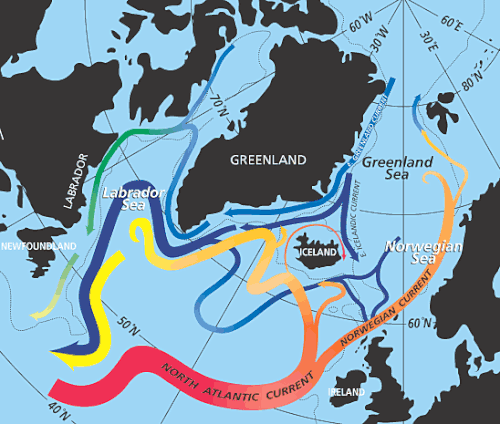
北大西洋環流の北では、サイクロン性の北大西洋亜極環流が気候変動に重要な役割を果たしている。この環流は、深海と海面の両方で風によって方向づけられるのではなく、縁海からの海流と地域の地形によって支配されている。[40] 亜極環流は、地球規模の熱塩循環の重要な部分を形成している。その東部には、亜熱帯から北東大西洋に暖かく塩分を含んだ水を運ぶ 北大西洋海流の渦巻く支流が含まれている。そこでこの水は冬の間に冷やされ、グリーンランドの東大陸斜面に沿って合流する戻り流を形成し、ラブラドル海の大陸棚の周りを流れる強い(40~50 Sv )海流を形成する。この水の3分の1は、北大西洋深層水(NADW)の深部の一部となる。 NADWは、南北循環(MOC)に熱を供給しますが、その北向きの熱輸送は人為的な気候変動によって脅かされています。北大西洋振動に関連する10年から100年スケールでの亜極環流の大きな変動は、特にMOCの上層であるラブラドル海水で顕著です。 [41]
南大西洋は、高気圧性の南方亜熱帯環流に支配されている。南大西洋中央水はこの環流から発生し、南極中層水はドレーク海峡とフォークランド諸島付近の周極域の上層から発生する。これらの海流は両方ともインド洋からいくらかの影響を受けています。アフリカ東海岸では、小さなサイクロン性のアンゴラ環流が大きな亜熱帯環流の中に埋め込まれています。[42] 南方亜熱帯環流は、風によって生じたエクマン層によって部分的に隠されています。環流の滞留時間は4.4~8.5年です。北大西洋深層水は、亜熱帯環流のサーモクライン下を南に流れています。 [43]
サルガッソー海
北大西洋西部のサルガッソー海は、2種のホンダワラ類(S. fluitansとnatans)が浮かぶ海域と定義することができ、その幅は4,000 km(2,500 mi)で、メキシコ湾流、北大西洋流、北赤道流に囲まれている。この海藻の個体群は、おそらく旧テチス海のヨーロッパ沿岸の第三紀の祖先に由来し、もしそうだとすれば、何百万年もの間海に浮かびながら、植物成長によって自らを維持してきた。 [44]
サルガッソー海固有の他の種には、藻類のような付属肢を持ち、サルガッソーの間でじっと浮かんでいる捕食者であるホンダワラ類が含まれる。同様の魚の化石は、現在のカルパティア地方にある、サルガッソー海に似たかつてのテチス海の化石湾で発見されている。テチス海が中新世の終わり、およそ1700万年前、閉鎖したため、サルガッソー海の個体群が大西洋に移動した可能性がある。[44]サルガッソーの動植物の起源は、何世紀にもわたって謎のままであった。 20世紀半ばにカルパティア山脈で発見された化石は「準サルガッソ群集」と呼ばれることが多く、最終的にこの群集がカルパティア盆地に起源を持ち、そこからシチリア島を越えて大西洋中央部に移動し、そこでサルガッソ海の現代種に進化したことが示された。[45]
ヨーロッパウナギの産卵場は数十年にわたって不明であった。19世紀初頭、南サルガッソー海がヨーロッパウナギとアメリカウナギの両方の産卵場であり、前者は5,000 km(3,100マイル)以上、後者は2,000 km(1,200マイル)以上移動することが判明した。メキシコ湾流などの海流は、サルガッソー海から北米、ヨーロッパ、北アフリカの採餌地域にウナギの幼生を運んでいる。[46]最近の研究では、ウナギは幼生と成体の両方で地球の磁場を利用して海を移動している可能性があることが示唆されているが、これには異論もある。[47]
気候

気候は、風だけでなく、表層水や水流の温度にも影響されます。海洋は熱を蓄え、放出する能力が大きいため、海洋性気候は内陸性気候よりも穏やかで、季節による変化もそれほど大きくありません。降水量は沿岸部の気象データから、気温は水温から概算できます。[25]
海洋は蒸発によって得られる大気中の水分の主な供給源である。気候帯は緯度によって異なり、最も暖かい地域は赤道の北の大西洋に広がっている。最も寒い地域は高緯度にあり、最も寒い地域は海氷に覆われた地域に該当する。海流は暖かい水と冷たい水を他の地域に運ぶことで気候に影響を与える。これらの海流を吹き抜けるときに冷やされたり温められたりした風は、隣接する陸地に影響を与える。[25]
メキシコ湾流と、その北のヨーロッパへの延長である北大西洋流は、気候に少なくともいくらかの影響を与えていると考えられている。例えば、メキシコ湾流は北アメリカ南東部の海岸線沿いの冬の気温を和らげ、内陸部よりも海岸沿いの冬を暖かく保つ。メキシコ湾流はまた、フロリダ半島で極端な気温が発生するのを防ぐ。高緯度では、北大西洋流は海上の大気を温め、イギリス諸島と北西ヨーロッパを穏やかで曇り空に保ち、同じ高緯度にある他の場所のように冬に極寒にならないようにする。冷水流は、カナダ東部(ニューファンドランド島のグランドバンクス地域)の海岸とアフリカの北西海岸の沖合に濃い霧をもたらす。一般的に、風は陸地の上に水分と空気を運ぶ。[25]
自然災害

毎年冬になると、アイスランド低気圧が頻繁に嵐を引き起こす。ニューファンドランド島のグランドバンクス付近の航路では、2月初旬から7月末まで氷山がよく見られる。極地では氷期が長いが、その地域では船舶の運行はほとんど行われていない。[48]
ハリケーンは夏から秋にかけて北大西洋西部で危険となる。一貫して強い風のせん断と弱い熱帯収束帯のため、南大西洋の熱帯低気圧はまれである。[49]
地質学とプレートテクトニクス
大西洋の海底の大部分は、玄武岩と斑れい岩からなる緻密な塩基性海洋地殻で覆われ、その上に深海平原の細かい粘土、シルト、珪質の軟泥が覆っている。大陸縁辺と大陸棚は、密度は低いが厚い珪長質大陸岩で、海底のものよりはるかに古いことが多い。大西洋で最も古い海洋地殻は1億4500万年前のもので、アフリカ西岸沖と北アメリカ東岸沖、または南大西洋の両側に位置している。[50]
多くの場所で、大陸棚と大陸斜面は厚い堆積層で覆われています。たとえば、北アメリカ側の海では、フロリダやバハマなどの暖かく浅い海域で大きな炭酸塩堆積物が形成され、ジョージズバンクなどの浅い棚地域では粗い川の流出砂とシルトがよく見られます。更新世の氷河期には、ノバスコシア沖やメイン湾などの一部の地域に粗い砂、玉石、岩が運ばれました。[51]
中央大西洋
中央大西洋の拡大 2億~1億7千万年前
パンゲアの分裂は、北アメリカと北西アフリカの間の中央大西洋で始まり、三畳紀後期からジュラ紀前期にかけて地溝帯が開いた。この時期には、アトラス山脈の隆起の最初の段階も見られた。正確な時期については議論があり、2億年から1億7千万年前と推定されている。[52]
大西洋の開裂は超大陸パンゲアの最初の分裂と一致しており、その両方は中央大西洋マグマ区(CAMP)の噴火によって引き起こされました。CAMPは地球史上最も広大で体積の多い大規模火成岩区の1つであり、地球の主要な絶滅イベントの1つである三畳紀-ジュラ紀絶滅イベントに関連しています。[53] 2億年前のCAMP噴火による セオライト岩脈、岩床、溶岩流は、西アフリカ、北アメリカ東部、南アメリカ北部で発見されています。火山活動の範囲は4.5×10⁶km2(1.7×10⁶平方マイル)と推定されており、そのうち2.5×10⁶km2(9.7× 10⁵平方マイル)が現在 のブラジル 北部 と中央部を覆っていまし た。[54]
中央アメリカ地峡の形成により、280万年前の鮮新世末期に中央アメリカ海路は閉鎖された。地峡の形成は、大アメリカ大陸間交流として知られる多くの陸生動物の移動と絶滅をもたらしたが、海路の閉鎖は大西洋と太平洋の両方の海流、塩分、温度に影響を与えた「大アメリカ分裂」をもたらした。地峡の両側の海洋生物は孤立し、分岐するか絶滅した。[55]
北大西洋
地質学的には、北大西洋は南にニューファンドランドとイベリアの2つの共役な縁、北にユーラシア北極海盆によって区切られた地域です。北大西洋の広がりは、その前身であるイアペトゥス海の縁に沿って進み、中央大西洋からイベリア–ニューファンドランド、ポーキュパイン–北アメリカ、ユーラシア–グリーンランド、ユーラシア–北アメリカの6段階に分かれて広がりました。この地域の活発な拡大システムと非活発な拡大システムは、アイスランドホットスポットとの相互作用によって特徴付けられます。[56]
海底の拡大により地殻が伸び、トラフや堆積盆地が形成されました。ロッコール・トラフは1億500万年前から8400万年前に開きましたが、ビスケー湾に通じる裂け目とともに崩壊しました。[57]
ラブラドル海の拡大は約 6100 万年前に始まり、3600 万年前まで続きました。地質学者は 2 つのマグマ段階を区別しています。1 つは 6200 万年前から 5800 万年前のもので、グリーンランドが北ヨーロッパから分離する前の段階です。もう 1 つは 5600 万年前から 5200 万年前のもので、分離が起こったときに起こりました。
アイスランドは、特に集中したマントルプルームによって6200万年前に形成され始めた。この時期に噴出した大量の玄武岩は、バッフィン島、グリーンランド、フェロー諸島、スコットランドで発見されており、西ヨーロッパの火山灰は地層の目印となっている。 [58]北大西洋の開口は、沿岸に沿って大陸地殻の大幅な隆起を引き起こした。例えば、東グリーンランドのガンビョルン平原は、7kmの厚さの玄武岩にもかかわらず、島で最も高い地点であり、その基部には古い中生代の堆積岩が露出している。これは、隆起したスコットランド西部のヘブリディーズ諸島の堆積岩の上にある古い溶岩原に似ている。[59]
北大西洋には約810の海山があり、そのほとんどは大西洋中央海嶺に沿って位置しています。[60] OSPARデータベース(北東大西洋の海洋環境の保護に関する条約)には104の海山が記載されており、そのうち74は国の排他的経済水域内にあります。これらの海山のうち46はイベリア半島の近くにあります。
南大西洋
南大西洋の開通
西ゴンドワナ(南アメリカとアフリカ)は白亜紀前期に分裂して南大西洋を形成した。両大陸の海岸線がぴったりと合っている様子は、南大西洋を含む最初の地図に記されており、1965年にはコンピューターによる最初のプレートテクトニクス再構築の対象にもなった。[61] [62]しかし、この見事な適合はその後問題が判明し、その後の再構築では、北向きに伝播する分裂に対応するために海岸線に沿ってさまざまな変形帯が導入された。[61]大陸内の亀裂や変形も導入され、両大陸プレートがサブプレートに分割された。[63]
Geologically, the South Atlantic can be divided into four segments: equatorial segment, from 10°N to the Romanche fracture zone (RFZ); central segment, from RFZ to Florianopolis fracture zone (FFZ, north of Walvis Ridge and Rio Grande Rise); southern segment, from FFZ to the Agulhas-Falkland fracture zone (AFFZ); and Falkland segment, south of AFFZ.[64]
In the southern segment the Early Cretaceous (133–130 Ma) intensive magmatism of the Paraná–Etendeka Large Igneous Province produced by the Tristan hotspot resulted in an estimated volume of 1.5×10⁶ to 2.0×10⁶ km3 (3.6×10⁵ to 4.8×10⁵ cu mi). It covered an area of 1.2×10⁶ to 1.6×10⁶ km2 (4.6×10⁵ to 6.2×10⁵ sq mi) in Brazil, Paraguay, and Uruguay and 0.8×10⁵ km2 (3.1×10⁴ sq mi) in Africa. Dyke swarms in Brazil, Angola, eastern Paraguay, and Namibia, however, suggest the LIP originally covered a much larger area and also indicate failed rifts in all these areas. Associated offshore basaltic flows reach as far south as the Falkland Islands and South Africa. Traces of magmatism in both offshore and onshore basins in the central and southern segments have been dated to 147–49 Ma with two peaks between 143 and 121 Ma and 90–60 Ma.[64]
In the Falkland segment rifting began with dextral movements between the Patagonia and Colorado sub-plates between the Early Jurassic (190 Ma) and the Early Cretaceous (126.7 Ma). Around 150 Ma sea-floor spreading propagated northward into the southern segment. No later than 130 Ma rifting had reached the Walvis Ridge–Rio Grande Rise.[63]
In the central segment, rifting started to break Africa in two by opening the Benue Trough around 118 Ma. Rifting in the central segment, however, coincided with the Cretaceous Normal Superchron (also known as the Cretaceous quiet period), a 40 Ma period without magnetic reversals, which makes it difficult to date sea-floor spreading in this segment.[63]
The equatorial segment is the last phase of the break-up, but, because it is located on the Equator, magnetic anomalies cannot be used for dating. Various estimates date the propagation of seafloor spreading in this segment and consequent opening of the Equatorial Atlantic Gateway (EAG) to the period 120–96 Ma.[65][66] This final stage, nevertheless, coincided with or resulted in the end of continental extension in Africa.[63]
About 50 Ma the opening of the Drake Passage resulted from a change in the motions and separation rate of the South American and Antarctic plates. First, small ocean basins opened and a shallow gateway appeared during the Middle Eocene. 34–30 Ma a deeper seaway developed, followed by an Eocene–Oligocene climatic deterioration and the growth of the Antarctic ice sheet.[67]
Closure of the Atlantic
An embryonic subduction margin is potentially developing west of Gibraltar. The Gibraltar Arc in the western Mediterranean is migrating westward into the central Atlantic where it joins the converging African and Eurasian plates. Together these three tectonic forces are slowly developing into a new subduction system in the eastern Atlantic Basin. Meanwhile, the Scotia Arc and Caribbean Plate in the western Atlantic Basin are eastward-propagating subduction systems that might, together with the Gibraltar system, represent the beginning of the closure of the Atlantic Ocean and the final stage of the Atlantic Wilson cycle.[68]
History
Human origin
Humans evolved in Africa; around 7 mya; then developing stone tools around 2.6 mya; to finally evolve as modern humans around 200 kya. The earliest evidence for the complex behavior associated with this behavioral modernity has been found in the Greater Cape Floristic Region (GCFR) along the coast of South Africa. During the latest glacial stages, the now-submerged plains of the Agulhas Bank were exposed above sea level, extending the South African coastline farther south by hundreds of kilometers. A small population of modern humans – probably fewer than a thousand reproducing individuals – survived glacial maxima by exploring the high diversity offered by these Palaeo-Agulhas plains. The GCFR is delimited to the north by the Cape Fold Belt and the limited space south of it resulted in the development of social networks out of which complex Stone Age technologies emerged.[69] Human history thus begins on the coasts of South Africa where the Atlantic Benguela Upwelling and the Indian Ocean Agulhas Current meet to produce an intertidal zone on which shellfish, fur seal, fish and sea birds provided the necessary protein sources.[70] The African origin of this modern behaviour is evidenced by 70,000 years-old engravings from Blombos Cave, South Africa.[71]
Old World
Mitochondrial DNA (mtDNA) studies indicate that 80–60,000 years ago a major demographic expansion within Africa, derived from a single, small population, coincided with the emergence of behavioral complexity and the rapid MIS 5–4 environmental changes. This group of people not only expanded over the whole of Africa, but also started to disperse out of Africa into Asia, Europe, and Australasia around 65,000 years ago and quickly replaced the archaic humans in these regions.[72] During the Last Glacial Maximum (LGM) 20,000 years ago humans had to abandon their initial settlements along the European North Atlantic coast and retreat to the Mediterranean. Following rapid climate changes at the end of the LGM this region was repopulated by Magdalenian culture. Other hunter-gatherers followed in waves interrupted by large-scale hazards such as the Laacher See volcanic eruption, the inundation of Doggerland (now the North Sea), and the formation of the Baltic Sea.[73] The European coasts of the North Atlantic were permanently populated about 9–8.5 thousand years ago.[74]
This human dispersal left abundant traces along the coasts of the Atlantic Ocean. 50 kya-old, deeply stratified shell middens found in Ysterfontein on the western coast of South Africa are associated with the Middle Stone Age (MSA). The MSA population was small and dispersed and the rate of their reproduction and exploitation was less intense than those of later generations. While their middens resemble 12–11 kya-old Late Stone Age (LSA) middens found on every inhabited continent, the 50–45 kya-old Enkapune Ya Muto in Kenya probably represents the oldest traces of the first modern humans to disperse out of Africa.[75]
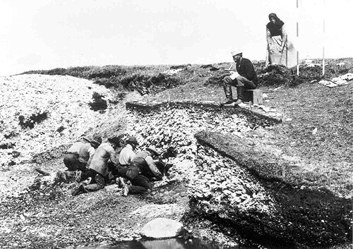
The same development can be seen in Europe. In La Riera Cave (23–13 kya) in Asturias, Spain, only some 26,600 molluscs were deposited over 10 kya. In contrast, 8–7 kya-old shell middens in Portugal, Denmark, and Brazil generated thousands of tons of debris and artefacts. The Ertebølle middens in Denmark, for example, accumulated 2,000 m3 (71,000 cu ft) of shell deposits representing some 50 million molluscs over only a thousand years. This intensification in the exploitation of marine resources has been described as accompanied by new technologies – such as boats, harpoons, and fish hooks – because many caves found in the Mediterranean and on the European Atlantic coast have increased quantities of marine shells in their upper levels and reduced quantities in their lower. The earliest exploitation, however, took place on the now submerged shelves, and most settlements now excavated were then located several kilometers from these shelves. The reduced quantities of shells in the lower levels can represent the few shells that were exported inland.[76]
New World
During the LGM the Laurentide Ice Sheet covered most of northern North America while Beringia connected Siberia to Alaska. In 1973, late American geoscientist Paul S. Martin proposed a "blitzkrieg" colonization of the Americas by which Clovis hunters migrated into North America around 13,000 years ago in a single wave through an ice-free corridor in the ice sheet and "spread southward explosively, briefly attaining a density sufficiently large to overkill much of their prey."[77] Others later proposed a "three-wave" migration over the Bering Land Bridge.[78] These hypotheses remained the long-held view regarding the settlement of the Americas, a view challenged by more recent archaeological discoveries: the oldest archaeological sites in the Americas have been found in South America; sites in northeast Siberia report virtually no human presence there during the LGM; and most Clovis artefacts have been found in eastern North America along the Atlantic coast.[79] Furthermore, colonisation models based on mtDNA, yDNA, and atDNA data respectively support neither the "blitzkrieg" nor the "three-wave" hypotheses but they also deliver mutually ambiguous results. Contradictory data from archaeology and genetics will most likely deliver future hypotheses that will, eventually, confirm each other.[80] A proposed route across the Pacific to South America could explain early South American finds and another hypothesis proposes a northern path, through the Canadian Arctic and down the North American Atlantic coast.[81] Early settlements across the Atlantic have been suggested by alternative theories, ranging from purely hypothetical to mostly disputed, including the Solutrean hypothesis and some of the Pre-Columbian trans-oceanic contact theories.

The Norse settlement of the Faroe Islands and Iceland began during the 9th and 10th centuries. A settlement on Greenland was established before 1000 CE, but contact with it was lost in 1409 and it was finally abandoned during the early Little Ice Age. This setback was caused by a range of factors: an unsustainable economy resulted in erosion and denudation, while conflicts with the local Inuit resulted in the failure to adapt their Arctic technologies; a colder climate resulted in starvation, and the colony got economically marginalized as the Great Plague harvested its victims on Iceland in the 15th century.[82] Iceland was initially settled 865–930 CE following a warm period when winter temperatures hovered around 2 °C (36 °F) which made farming favorable at high latitudes. This did not last, however, and temperatures quickly dropped; at 1080 CE summer temperatures had reached a maximum of 5 °C (41 °F). The Landnámabók (Book of Settlement) records disastrous famines during the first century of settlement – "men ate foxes and ravens" and "the old and helpless were killed and thrown over cliffs" – and by the early 1200s hay had to be abandoned for short-season crops such as barley.[83]
Atlantic World

Christopher Columbus reached the Americas in 1492, sailing under the Spanish flag.[84] Six years later Vasco da Gama reached India under the Portuguese flag, by navigating south around the Cape of Good Hope, thus proving that the Atlantic and Indian Oceans are connected. In 1500, in his voyage to India following Vasco da Gama, Pedro Álvares Cabral reached Brazil, taken by the currents of the South Atlantic Gyre. Following these explorations, Spain and Portugal quickly conquered and colonized large territories in the New World and forced the Amerindian population into slavery in order to exploit the vast quantities of silver and gold they found. Spain and Portugal monopolized this trade in order to keep other European nations out, but conflicting interests nevertheless led to a series of Spanish-Portuguese wars. A peace treaty mediated by the Pope divided the conquered territories into Spanish and Portuguese sectors while keeping other colonial powers away. England, France, and the Dutch Republic enviously watched the Spanish and Portuguese wealth grow and allied themselves with pirates such as Henry Mainwaring and Alexandre Exquemelin. They could explore the convoys leaving the Americas because prevailing winds and currents made the transport of heavy metals slow and predictable.[84]

In the colonies of the Americas, depredation, smallpox and other diseases, and slavery quickly reduced the indigenous population of the Americas to the extent that the Atlantic slave trade had to be introduced to replace them – a trade that became the norm and an integral part of the colonization. Between the 15th century and 1888, when Brazil became the last part of the Americas to end the slave trade, an estimated ten million Africans were exported as slaves, most of them destined for agricultural labour. The slave trade was officially abolished in the British Empire and the United States in 1808, and slavery itself was abolished in the British Empire in 1838 and in the United States in 1865 after the Civil War.[85][86]
From Columbus to the Industrial Revolution trans-Atlantic trade, including colonialism and slavery, became crucial for Western Europe. For European countries with direct access to the Atlantic (including Britain, France, the Netherlands, Portugal, and Spain) 1500–1800 was a period of sustained growth during which these countries grew richer than those in Eastern Europe and Asia. Colonialism evolved as part of the trans-Atlantic trade, but this trade also strengthened the position of merchant groups at the expense of monarchs. Growth was more rapid in non-absolutist countries, such as Britain and the Netherlands, and more limited in absolutist monarchies, such as Portugal, Spain, and France, where profit mostly or exclusively benefited the monarchy and its allies.[87]
Trans-Atlantic trade also resulted in increasing urbanization: in European countries facing the Atlantic, urbanization grew from 8% in 1300, 10.1% in 1500, to 24.5% in 1850; in other European countries from 10% in 1300, 11.4% in 1500, to 17% in 1850. Likewise, GDP doubled in Atlantic countries but rose by only 30% in the rest of Europe. By the end of the 17th century, the volume of the Trans-Atlantic trade had surpassed that of the Mediterranean trade.[87]
Economy
The Atlantic has contributed significantly to the development and economy of surrounding countries. Besides major transatlantic transportation and communication routes, the Atlantic offers abundant petroleum deposits in the sedimentary rocks of the continental shelves.[25]

The Atlantic harbors petroleum and gas fields, fish, marine mammals (seals and whales), sand and gravel aggregates, placer deposits, polymetallic nodules, and precious stones.[88] Gold deposits are a mile or two underwater on the ocean floor, however, the deposits are also encased in rock that must be mined through. Currently, there is no cost-effective way to mine or extract gold from the ocean to make a profit.[89]
Various international treaties attempt to reduce pollution caused by environmental threats such as oil spills, marine debris, and the incineration of toxic wastes at sea.[25]
Fisheries
The shelves of the Atlantic hosts one of the world's richest fishing resources. The most productive areas include the Grand Banks of Newfoundland, the Scotian Shelf, Georges Bank off Cape Cod, the Bahama Banks, the waters around Iceland, the Irish Sea, the Bay of Fundy, the Dogger Bank of the North Sea, and the Falkland Banks.[25] Fisheries have, however, undergone significant changes since the 1950s and global catches can now be divided into three groups of which only two are observed in the Atlantic: fisheries in the eastern-central and southwest Atlantic oscillate around a globally stable value, the rest of the Atlantic is in overall decline following historical peaks. The third group, "continuously increasing trend since 1950", is only found in the Indian Ocean and western Pacific.[90]
UN FAO partitioned the Atlantic into major fishing areas:
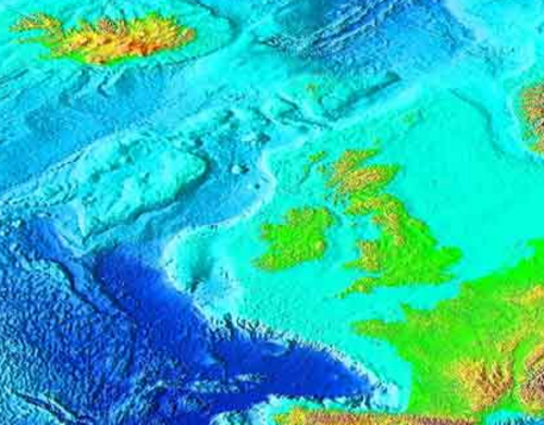
- Northeast Atlantic
Northeast Atlantic is schematically limited to the 40°00' west longitude (except around Greenland), south to the 36°00' north latitude, and to the 68°30' east longitude, with both the west and east longitude limits reaching to the north pole. The Atlantic's subareas include: Barents Sea; Norwegian Sea, Spitzbergen, and Bear Island; Skagerrak, Kattegat, Sound, Belt Sea, and Baltic Sea; North Sea; Iceland and Faroes Grounds; Rockall, Northwest Coast of Scotland, and North Ireland; Irish Sea, West of Ireland, Porcupine Bank, and eastern and western English Channel; Bay of Biscay; Portuguese Waters; Azores Grounds and Northeast Atlantic South; North of Azores; and East Greenland. There are also two defunct subareas.[91]
- In the Northeast Atlantic total catches decreased between the mid-1970s and the 1990s and reached 8.7 million tons in 2013. Blue whiting reached a 2.4 million tons peak in 2004 but was down to 628,000 tons in 2013. Recovery plans for cod, sole, and plaice have reduced mortality in these species. Arctic cod reached its lowest levels in the 1960s–1980s but is now recovered. Arctic saithe and haddock are considered fully fished; Sand eel is overfished as was capelin which has now recovered to fully fished. Limited data makes the state of redfishes and deep-water species difficult to assess but most likely they remain vulnerable to overfishing. Stocks of northern shrimp and Norwegian lobster are in good condition. In the Northeast Atlantic, 21% of stocks are considered overfished.[90]
- This zone makes almost three-quarters (72.8 %) of European Union fishing catches in 2020. Main fishing EU countries are Denmark, France, the Netherlands and Spain. Most common species include herring, mackerel, and sprats.
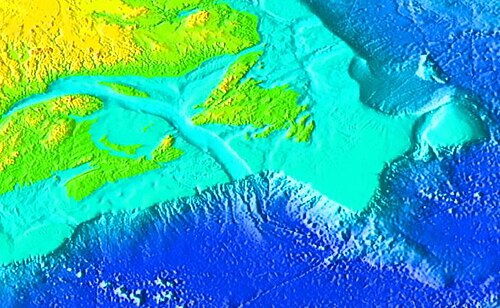
- Northwest Atlantic
- In the Northwest Atlantic landings have decreased from 4.2 million tons in the early 1970s to 1.9 million tons in 2013. During the 21st century, some species have shown weak signs of recovery, including Greenland halibut, yellowtail flounder, Atlantic halibut, haddock, spiny dogfish, while other stocks shown no such signs, including cod, witch flounder, and redfish. Stocks of invertebrates, in contrast, remain at record levels of abundance. 31% of stocks are overfished in the northwest Atlantic.[90]

In 1497, John Cabot became the first Western European since the Vikings to explore mainland North America and one of his major discoveries was the abundant resources of Atlantic cod off Newfoundland. Referred to as "Newfoundland Currency" this discovery yielded some 200 million tons of fish over five centuries. In the late 19th and early 20th centuries, new fisheries started to exploit haddock, mackerel, and lobster. From the 1950s to the 1970s, the introduction of European and Asian distant-water fleets in the area dramatically increased the fishing capacity and the number of exploited species. It also expanded the exploited areas from near-shore to the open sea and to great depths to include deep-water species such as redfish, Greenland halibut, witch flounder, and grenadiers. Overfishing in the area was recognized as early as the 1960s but, because this was occurring on international waters, it took until the late 1970s before any attempts to regulate was made. In the early 1990s, this finally resulted in the collapse of the Atlantic northwest cod fishery. The population of a number of deep-sea fishes also collapsed in the process, including American plaice, redfish, and Greenland halibut, together with flounder and grenadier.[92]
- Eastern central-Atlantic
- In the eastern central-Atlantic small pelagic fishes constitute about 50% of landings with sardine reaching 0.6–1.0 million tons per year. Pelagic fish stocks are considered fully fished or overfished, with sardines south of Cape Bojador the notable exception. Almost half of the stocks are fished at biologically unsustainable levels. Total catches have been fluctuating since the 1970s; reaching 3.9 million tons in 2013 or slightly less than the peak production in 2010.[90]

- Western central-Atlantic
- In the western central-Atlantic, catches have been decreasing since 2000 and reached 1.3 million tons in 2013. The most important species in the area, Gulf menhaden, reached a million tons in the mid-1980s but only half a million tons in 2013 and is now considered fully fished. Round sardinella was an important species in the 1990s but is now considered overfished. Groupers and snappers are overfished and northern brown shrimp and American cupped oyster are considered fully fished approaching overfished. 44% of stocks are being fished at unsustainable levels.[90]

- Southeast Atlantic
- In the southeast Atlantic catches have decreased from 3.3 million tons in the early 1970s to 1.3 million tons in 2013. Horse mackerel and hake are the most important species, together representing almost half of the landings. Off South Africa and Namibia deep-water hake and shallow-water Cape hake have recovered to sustainable levels since regulations were introduced in 2006 and the states of southern African pilchard and anchovy have improved to fully fished in 2013.[90]
- Southwest Atlantic
- In the southwest Atlantic, a peak was reached in the mid-1980s and catches now fluctuate between 1.7 and 2.6 million tons. The most important species, the Argentine shortfin squid, which reached half a million tons in 2013 or half the peak value, is considered fully fished to overfished. Another important species was the Brazilian sardinella, with a production of 100,000 tons in 2013 it is now considered overfished. Half the stocks in this area are being fished at unsustainable levels: Whitehead's round herring has not yet reached fully fished but Cunene horse mackerel is overfished. The sea snail perlemoen abalone is targeted by illegal fishing and remains overfished.[90]
Environmental issues
Endangered species
Endangered marine species include the manatee, seals, sea lions, turtles, and whales. Drift net fishing can kill dolphins, albatrosses and other seabirds (petrels, auks), hastening the fish stock decline and contributing to international disputes.[93]
Waste and pollution
Marine pollution is a generic term for the entry into the ocean of potentially hazardous chemicals or particles. The biggest culprits are rivers and with them many agriculture fertilizer chemicals as well as livestock and human waste. The excess of oxygen-depleting chemicals leads to hypoxia and the creation of a dead zone.[94]
.jpg/500px-Nesocichla_eremita_-Inaccessible_Island,_British_overseas_territory-8_(3).jpg)
Marine debris, which is also known as marine litter, describes human-created waste floating in a body of water. Oceanic debris tends to accumulate at the center of gyres and coastlines, frequently washing aground where it is known as beach litter. The North Atlantic garbage patch is estimated to be hundreds of kilometers across in size.[95]
Other pollution concerns include agricultural and municipal waste. Municipal pollution comes from the eastern United States, southern Brazil, and eastern Argentina; oil pollution in the Caribbean Sea, Gulf of Mexico, Lake Maracaibo, Mediterranean Sea, and North Sea; and industrial waste and municipal sewage pollution in the Baltic Sea, North Sea, and Mediterranean Sea.
A USAF C-124 aircraft from Dover Air Force Base, Delaware was carrying three nuclear bombs over the Atlantic Ocean when it experienced a loss of power. For their own safety, the crew jettisoned two nuclear bombs, which were never recovered.[96]
Climate change
North Atlantic hurricane activity has increased over past decades because of increased sea surface temperature (SST) at tropical latitudes, changes that can be attributed to either the natural Atlantic Multidecadal Oscillation (AMO) or to anthropogenic climate change.[97] A 2005 report indicated that the Atlantic meridional overturning circulation (AMOC) slowed down by 30% between 1957 and 2004.[98] In 2024, the research highlighted a significant weakening of the AMOC by approximately 12% over the past two decades.[99] If the AMO were responsible for SST variability, the AMOC would have increased in strength, which is apparently not the case. Furthermore, it is clear from statistical analyses of annual tropical cyclones that these changes do not display multidecadal cyclicity.[97] Therefore, these changes in SST must be caused by human activities.[100]
The ocean mixed layer plays an important role in heat storage over seasonal and decadal time scales, whereas deeper layers are affected over millennia and have a heat capacity about 50 times that of the mixed layer. This heat uptake provides a time-lag for climate change but it also results in thermal expansion of the oceans which contributes to sea level rise. 21st-century global warming will probably result in an equilibrium sea-level rise five times greater than today, whilst melting of glaciers, including that of the Greenland ice sheet, expected to have virtually no effect during the 21st century, will likely result in a sea-level rise of 3–6 metres (9.8–19.7 ft) over a millennium.[101]
Theories of natural delimitation between the Atlantic and Pacific oceans

Scientific researchers have proposed delimiting the boundary between the Atlantic and Pacific oceans by two different natural boundaries, by the Shackleton Fracture Zone[102] and by the Scotia Arc[103][104][105] the former being more current than the latter.
See also




- Atlantic Revolutions
- List of countries and territories bordering the Atlantic Ocean
- List of rivers of the Americas by coastline § Atlantic Ocean coast
- Seven Seas
- Shipwrecks in the Atlantic Ocean
- Atlantic hurricanes
- Piracy in the Atlantic World
- Transatlantic crossing
- South Atlantic Peace and Cooperation Zone
- Natural delimitation between the Pacific and South Atlantic oceans by the Scotia Arc
References
- ^ a b c d CIA World Factbook: Atlantic Ocean
- ^ a b "Atlantic Ocean". Encyclopædia Britannica. Archived from the original on 15 February 2017. Retrieved 20 December 2016.
- ^ a b c d Eakins & Sharman 2010
- ^ Dean, Josh (21 December 2018). "An inside look at the first solo trip to the deepest point of the Atlantic". Popular Science. Retrieved 22 December 2018.
- ^ International Hydrographic Organization, Limits of Oceans and Seas, 3rd ed. (1953), pages 4 and 13.
- ^ Mangas, Julio; Plácido, Domingo; Elícegui, Elvira Gangutia; Rodríguez Somolinos, Helena (1998). La Península Ibérica en los autores griegos: de Homero a Platón – SLG / (Sch. A. R. 1. 211). Editorial Complutense. pp. 283–.
- ^ "Ἀτλαντίς, DGE Diccionario Griego-Español". dge.cchs.csic.es. Archived from the original on 1 January 2018.
- ^ Hdt. 1.202.4
- ^ a b Oxford Dictionaries 2015
- ^ Janni 2015, p. 27
- ^ Ripley & Anderson Dana 1873
- ^ Steele, Ian Kenneth (1986). The English Atlantic, 1675–1740: An Exploration of Communication and Community. Oxford University Press. p. 14. ISBN 978-0-19-503968-9.
- ^ "pond". Oxford English and Spanish Dictionary, Synonyms, and Spanish to English Translator. Archived from the original on 14 May 2021. Retrieved 28 September 2021.
- ^ "Pond". Online Etymology Dictionary. Douglas Harper. Retrieved 1 February 2019.
- ^ Wellington, Nehemiah (1 January 1869). Historical Notices of Events Occurring Chiefly in the Reign of Charles I. London: Richard Bentley.
- ^ Brown, Laurence (8 April 2018). Lost in The Pond (Digital video). YouTube. Archived from the original on 22 November 2021.
- ^ a b IHO 1953
- ^ CIA World Factbook: Pacific Ocean
- ^ USGS: Mapping Puerto Rico Trench
- ^ "Atlantic Ocean". Five Deeps Expedition. Retrieved 24 January 2020.
- ^ June 2010, Remy Melina 04 (4 June 2010). "The World's Biggest Oceans and Seas". Live Science.
{{cite web}}: CS1 maint: numeric names: authors list (link) - ^ "World Map / World Atlas / Atlas of the World Including Geography Facts and Flags". WorldAtlas.
- ^ "List of seas". listofseas.com.
- ^ a b c World Heritage Centre: Mid-Atlantic Ridge
- ^ a b c d e f g h i j k l U.S. Navy 2001
- ^ a b c Levin & Gooday 2003, Seafloor topography and physiography, pp. 113–114
- ^ The Geological Society: Mid-Atlantic Ridge
- ^ Kenneth J. Hsü (1987). The Mediterranean Was a Desert: A Voyage of the Glomar Challenger. Princeton University Press. ISBN 978-0-691-02406-6.
- ^ DeMets, Gordon & Argus 2010, The Azores microplate, pp. 24–25
- ^ DeMets, Gordon & Argus 2010, Boundary between the North and South America plates, pp. 26–27
- ^ Thomson 1877, p. 290
- ^ NOAA: Timeline
- ^ Hamilton-Paterson, James (1992). The Great Deep.
- ^ Marsh et al. 2007, Introduction, p. 1
- ^ Emery & Meincke 1986, Table, p. 385
- ^ a b Emery & Meincke 1986, Atlantic Ocean, pp. 384–386
- ^ Smethie et al. 2000, Formation of NADW, pp. 14299–14300
- ^ Smethie et al. 2000, Introduction, p. 14297
- ^ Marchal, Waelbroeck & Colin de Verdière 2016, Introduction, pp. 1545–1547
- ^ Tréguier et al. 2005, Introduction, p. 757
- ^ Böning et al. 2006, Introduction, p. 1; Fig. 2, p. 2
- ^ Stramma & England 1999, Abstract
- ^ Gordon & Bosley 1991, Abstract
- ^ a b Lüning 1990, pp. 223–225
- ^ Jerzmańska & Kotlarczyk 1976, Abstract; Biogeographic Significance of the "Quasi-Sargasso" Assemblage, pp. 303–304
- ^ Als et al. 2011, p. 1334
- ^ Marks, Andrea (17 April 2017). "Do Baby Eels Use Magnetic Maps to Hitch a Ride on the Gulf Stream?". Scientific American. Archived from the original on 19 April 2017. Retrieved 18 April 2017.
- ^ "About International Ice Patrol (IIP)". U. S. Coast Guard Navigation Center. Archived from the original on 5 December 2021.
- ^ Landsea, Chris (13 July 2005). "Why doesn't the South Atlantic Ocean experience tropical cyclones?". Atlantic Oceanographic and Meteorological Laboratory. National Oceanographic and Atmospheric Administration. Archived from the original on 12 June 2018. Retrieved 9 June 2018.
- ^ Fitton, Godfrey; Larsen, Lotte Melchior (1999). "The geological history of the North Atlantic Ocean". pp. 10, 15 – via ResearchGate.
- ^ Emery, K. O. (1962). "Atlantic Continental Shelf and Slope of the United States - Geologic Background" (PDF) (Report). US Geological Survey. p. 16. Archived (PDF) from the original on 9 October 2022.
- ^ Seton et al. 2012, Central Atlantic, pp. 218, 220
- ^ Blackburn et al. 2013, p. 941
- ^ Marzoli et al. 1999, p. 616
- ^ Lessios 2008, Abstract, Introduction, p. 64
- ^ Seton et al. 2012, Northern Atlantic, p. 220
- ^ Fitton & Larsen 1999, p. 15.
- ^ Fitton & Larsen 1999, p. 10.
- ^ Fitton & Larsen 1999, pp. 23–24.
- ^ Gubbay S. 2003. Seamounts of the northeast Atlantic. OASIS (Oceanic Seamounts: an Integrated Study). Hamburg & WWF, Frankfurt am Main, Germany
- ^ a b Eagles 2007, Introduction, p. 353
- ^ Bullard, Everett & Smith 1965
- ^ a b c d Seton et al. 2012, South Atlantic, pp. 217–218
- ^ a b Torsvik et al. 2009, General setting and magmatism, pp. 1316–1318
- ^ Giorgioni, Martino; Weissert, Helmut; Bernasconi, Stefano M.; Hochuli, Peter A.; Keller, Christina E.; Coccioni, Rodolfo; Petrizzo, Maria Rose; Lukeneder, Alexander; Garcia, Therese I. (March 2015). "Paleoceanographic changes during the Albian–Cenomanian in the Tethys and North Atlantic and the onset of the Cretaceous chalk". Global and Planetary Change. 126: 46–61. Bibcode:2015GPC...126...46G. doi:10.1016/j.gloplacha.2015.01.005. ISSN 0921-8181. Retrieved 2 December 2022.
- ^ De A. Carvalho, Marcelo; Bengtson, Peter; Lana, Cecília C. (23 November 2015). "Late Aptian (Cretaceous) paleoceanography of the South Atlantic Ocean inferred from dinocyst communities of the Sergipe Basin, Brazil". Paleoceanography and Paleoclimatology. 31 (1): 2–26. doi:10.1002/2014PA002772.
- ^ Livermore et al. 2005, Abstract
- ^ Duarte et al. 2013, Abstract; Conclusions, p. 842
- ^ Marean et al. 2014, pp. 164–166, fig. 8.2, p. 166
- ^ Marean 2011, Environmental Context on the South Coast, pp. 423–425
- ^ Henshilwood et al. 2002, Abstract
- ^ Mellars 2006, Abstract
- ^ Riede 2014, pp. 1–2
- ^ Bjerck 2009, Introduction, pp. 118–119
- ^ Avery et al. 2008, Introduction, p. 66
- ^ Bailey & Flemming 2008, The Long-Term History of Marine Resources, pp. 4–5
- ^ Martin 1973, Abstract
- ^ Greenberg, Turner & Zegura 1986
- ^ O'Rourke & Raff 2010, Introduction, p. 202
- ^ O'Rourke & Raff 2010, Conclusions and Outlook, p. 206
- ^ O'Rourke & Raff 2010, Beringian Scenarios, pp. 205–206
- ^ Dugmore, Keller & McGovern 2007, Introduction, pp. 12–13; The Norse in The North Atlantic, pp. 13–14
- ^ Patterson et al. 2010, pp. 5308–5309
- ^ a b Chambliss 1989, Piracy, pp. 184–188
- ^ Lovejoy 1982, Abstract
- ^ Bravo 2007, The Trans-Atlantic Slave Trade, pp. 213–215
- ^ a b Acemoglu, Johnson & Robinson 2005, Abstract; pp. 546–551
- ^ Kubesh, K.; McNeil, N.; Bellotto, K. (2008). Ocean Habitats. In the Hands of a Child. Archived from the original on 21 December 2016. Retrieved 5 December 2016.
- ^ Administration, US Department of Commerce, National Oceanic and Atmospheric. "Is there gold in the ocean?". oceanservice.noaa.gov. Archived from the original on 31 March 2016. Retrieved 30 March 2016.
{{cite web}}: CS1 maint: multiple names: authors list (link) - ^ a b c d e f g FOA 2016, pp. 39–41
- ^ "FAO Fisheries & Aquaculture". www.fao.org. Retrieved 7 August 2023.
- ^ FAO 2011, pp. 22–23
- ^ Eisenbud, R. (1985). "Problems and Prospects for the Pelagic Driftnet". Michigan State University, Animal Legal & Historical Center. Archived from the original on 25 November 2011. Retrieved 27 October 2011.
- ^ Sebastian A. Gerlach "Marine Pollution", Springer, Berlin (1975)
- ^ "Huge Garbage Patch Found in Atlantic Too". National Geographic. 2 March 2010. Archived from the original on 28 August 2019.
- ^ HR Lease (March 1986). "DoD Mishaps" (PDF). Armed Forces Radiobiology Research Institute. Archived from the original (PDF) on 18 December 2008.
- ^ a b Mann & Emanuel 2006, pp. 233–241
- ^ Bryden, Longworth & Cunningham 2005, Abstract
- ^ Marine, Rosenstiel School of; Atmospheric; Science, Earth. "Warming of Antarctic deep-sea waters contribute to sea level rise in North Atlantic, study finds". phys.org. Retrieved 19 April 2024.
- ^ Webster et al. 2005
- ^ Bigg et al. 2003, Sea-level change, pp. 1128–1129
- ^ Juan Ignacio Ipinza Mayor; Cedomir Marangunic Damianovic (2021). "ALGUNAS CONSECUENCIAS JURÍDICAS DE LA INVOCACIÓN POR PARTE DE CHILE DE LA "TEORÍA DE LA DELIMITACIÓN NATURAL DE LOS OCÉANOS" EN EL DIFERENDO SOBRE LA PLATAFORMA CONTINENTAL AUSTRAL". ANEPE (in Spanish).
- ^ Barros González, Guillermo (1987). "El Arco de Scotia, separación natural de los océanos Pacífico y Atlántico" (PDF). Revista de Marina (in Spanish). Retrieved 22 March 2021.
- ^ Passarelli, Bruno (1998). El delirio armado: Argentina-Chile, la guerra que evitó el Papa (in Spanish). Editorial Sudamericana. p. 48. ISBN 978-9-5007-1469-3.
- ^ Santibañez, Rafael (1969). "El Canal Beagle y la delimitación de los océanos". Los derechos de Chile en el Beagle (in Spanish). Santiago: Editorial Andrés Bello. pp. 95–109. OCLC 1611130. Retrieved 22 March 2021.
Sources
- Acemoglu, D.; Johnson, S.; Robinson, J. (2005). "The rise of Europe: Atlantic trade, institutional change and economic growth" (PDF). The American Economic Review. 95 (3): 546–579. doi:10.1257/0002828054201305. hdl:1721.1/64034. Archived (PDF) from the original on 9 October 2022. Retrieved 13 November 2016.
- Als, T.D.; Hansen, M.M.; Maes, G.E.; Castonguay, M.; Riemann, L.; Aarestrup, K.I.M.; Munk, P.; Sparholt, H.; Hanel, R.; Bernatchez, L. (2011). "All roads lead to home: panmixia of European eel in the Sargasso Sea" (PDF). Molecular Ecology. 20 (7): 1333–1346. Bibcode:2011MolEc..20.1333A. doi:10.1111/j.1365-294X.2011.05011.x. PMID 21299662. Archived from the original (PDF) on 9 August 2017. Retrieved 8 October 2016.
- Avery, G.; Halkett, D.; Orton, J.; Steele, T.; Tusenius, M.; Klein, R. (2008). "The Ysterfontein 1 Middle Stone Age rock shelter and the evolution of coastal foraging". Goodwin Series. 10: 66–89. Retrieved 26 November 2016.
- Bailey, G N.; Flemming, N.C. (2008). "Archaeology of the continental shelf: marine resources, submerged landscapes and underwater archaeology" (PDF). Quaternary Science Reviews. 27 (23): 2153–2165. Bibcode:2008QSRv...27.2153B. doi:10.1016/j.quascirev.2008.08.012. Archived (PDF) from the original on 9 October 2022. Retrieved 26 November 2016.
- Bigg, G.R.; Jickells, T.D.; Liss, P.S.; Osborn, T.J. (2003). "The role of the oceans in climate". International Journal of Climatology. 23 (10): 1127–1159. Bibcode:2003IJCli..23.1127B. doi:10.1002/joc.926. S2CID 128837630. Retrieved 20 November 2016.
- Bjerck, H.B. (2009). "Colonizing seascapes: comparative perspectives on the development of maritime relations in Scandinavia and Patagonia". Arctic Anthropology. 46 (1–2): 118–131. doi:10.1353/arc.0.0019. S2CID 128404669. [permanent dead link]
- Blackburn, T.J.; Olsen, P.E.; Bowring, S.A.; McLean, N.M.; Kent, D.V.; Puffer, J.; McHone, G.; Rasbury, T.; Et-Touhami, M. (2013). "Zircon U-Pb geochronology links the end-Triassic extinction with the Central Atlantic Magmatic Province" (PDF). Science. 340 (6135): 941–945. Bibcode:2013Sci...340..941B. CiteSeerX 10.1.1.1019.4042. doi:10.1126/science.1234204. PMID 23519213. S2CID 15895416. Archived (PDF) from the original on 9 October 2022. Retrieved 23 October 2016.
- Böning, C.W.; Scheinert, M.; Dengg, J.; Biastoch, A.; Funk, A. (2006). "Decadal variability of subpolar gyre transport and its reverberation in the North Atlantic overturning". Geophysical Research Letters. 33 (21): L21S01. Bibcode:2006GeoRL..3321S01B. doi:10.1029/2006GL026906. Retrieved 15 October 2016.
- Bravo, K.E. (2007). "Exploring the analogy between modern trafficking in humans and the trans-Atlantic slave trade" (PDF). Boston University International Law Journal. 25 (207). Archived (PDF) from the original on 9 October 2022. Retrieved 13 November 2016.
- Bryden, H.L.; Longworth, H.R.; Cunningham, S.A. (2005). "Slowing of the Atlantic meridional overturning circulation at 25 N" (PDF). Nature. 438 (7068): 655–657. Bibcode:2005Natur.438..655B. doi:10.1038/nature04385. PMID 16319889. S2CID 4429828. Archived (PDF) from the original on 9 October 2022. Retrieved 13 November 2016.
- Bullard, E.; Everett, J.E.; Smith, A.G. (1965). "The fit of the continents around the Atlantic" (PDF). Philosophical Transactions of the Royal Society of London A: Mathematical, Physical and Engineering Sciences. 258 (1088): 41–51. Bibcode:1965RSPTA.258...41B. doi:10.1098/rsta.1965.0020. PMID 17801943. S2CID 27169876. Archived (PDF) from the original on 9 October 2022. Retrieved 23 October 2016.
- Chambliss, W.J. (1989). "State-organized crime" (PDF). Criminology. 27 (2): 183–208. doi:10.1111/j.1745-9125.1989.tb01028.x. Archived from the original (PDF) on 12 November 2016. Retrieved 12 November 2016.
- "Atlantic Ocean". CIA World Factbook. 27 June 2016. Retrieved 2 October 2016.
- "Pacific Ocean". CIA World Factbook. 1 June 2016. Retrieved 2 October 2016.
- DeMets, C.; Gordon, R.G.; Argus, D.F. (2010). "Geologically current plate motions". Geophysical Journal International. 181 (1): 1–80. Bibcode:2010GeoJI.181....1D. doi:10.1111/j.1365-246X.2009.04491.x.
- Duarte, J.C.; Rosas, F.M.; Terrinha, P.; Schellart, W.P.; Boutelier, D.; Gutscher, M.A.; Ribeiro, A. (2013). "Are subduction zones invading the Atlantic? Evidence from the southwest Iberia margin". Geology. 41 (8): 839–842. Bibcode:2013Geo....41..839D. doi:10.1130/G34100.1.
- Dugmore, A.J.; Keller, C.; McGovern, T.H. (2007). "Norse Greenland settlement: reflections on climate change, trade, and the contrasting fates of human settlements in the North Atlantic islands" (PDF). Arctic Anthropology. 44 (1): 12–36. doi:10.1353/arc.2011.0038. PMID 21847839. S2CID 10030083. Archived (PDF) from the original on 9 October 2022. Retrieved 7 November 2016.
- Eagles, G. (2007). "New angles on South Atlantic opening". Geophysical Journal International. 168 (1): 353–361. Bibcode:2007GeoJI.168..353E. doi:10.1111/j.1365-246X.2006.03206.x. S2CID 29158845.
- Eakins, B.W.; Sharman, G.F. (2010). "Volumes of the World's Oceans from ETOPO1". Boulder, CO: NOAA National Geophysical Data Center. Retrieved 1 October 2016.
- Emery, W.J.; Meincke, J. (1986). "Global water masses-summary and review" (PDF). Oceanologica Acta. 9 (4): 383–391 (PDF pages scrambled). Archived (PDF) from the original on 9 October 2022. Retrieved 16 October 2016.
- The State of World Fisheries and Aquaculture (PDF) (Report). Rome: Food and Agriculture Organization of the United Nations (FOA). 2016. ISBN 978-92-5-109185-2. Archived (PDF) from the original on 9 October 2022. Retrieved 3 December 2016.
- "Mid-Atlantic Ridge". The Geological Society. Retrieved 2 October 2016.
- Greenberg, J.H.; Turner, C.G.; Zegura, S.L. (1986). "The settlement of the Americas: A comparison of the linguistic, dental and genetic evidence". Current Anthropology. 27 (5): 477–497. doi:10.1086/203472. JSTOR 2742857. S2CID 144209907.
- Gordon, A.L.; Bosley, K.T. (1991). "Cyclonic gyre in the tropical South Atlantic" (PDF). Deep Sea Research Part A. Oceanographic Research Papers. 38: S323–S343. Bibcode:1991DSRA...38S.323G. doi:10.1016/S0198-0149(12)80015-X. Archived (PDF) from the original on 9 October 2022. Retrieved 15 October 2016.
- Henshilwood, C.S.; d'Errico, F.; Yates, R.; Jacobs, Z.; Tribolo, C.; Duller, G.A.; Mercier, N.; Sealy, J.C.; Valladas, H.; Watts, I.; Wintle, A.G. (2002). "Emergence of modern human behavior: Middle Stone Age engravings from South Africa" (PDF). Science. 295 (5558): 1278–1280. Bibcode:2002Sci...295.1278H. doi:10.1126/science.1067575. PMID 11786608. S2CID 31169551. Archived (PDF) from the original on 9 October 2022. Retrieved 6 November 2016.
- Herodotus. "Perseus Under Philologic: Hdt. 1.202.4". University of Chicago. Retrieved 1 October 2016.
- "Limits of Oceans and Seas" (PDF). Special Publication. 23 (4376): 484. 1953. Bibcode:1953Natur.172R.484.. doi:10.1038/172484b0. S2CID 36029611. Archived from the original (PDF) on 20 October 2016. Retrieved 28 December 2020. map
- Janni, P. (2015). "The Sea of the Greeks and Romans". In Bianchetti, S.; Cataudella, M.; Gehrke, H.-J. (eds.). Brill's Companion to Ancient Geography: The Inhabited World in Greek and Roman Tradition. Brill. pp. 21–42. doi:10.1163/9789004284715_003. ISBN 978-90-04-28471-5. Retrieved 1 October 2016.
- Jerzmańska, A.; Kotlarczyk, J. (1976). "The beginnings of the Sargasso assemblage in the Tethys?". Palaeogeography, Palaeoclimatology, Palaeoecology. 20 (4): 297–306. Bibcode:1976PPP....20..297J. doi:10.1016/0031-0182(76)90009-2. Retrieved 9 October 2016.
- Kulka, D. (2011). "B1. Northwest Atlantic" (PDF). Review of the state of world marine fishery resources. FAO Fisheries and Aquaculture Technical Paper (Report). Vol. 569. Rome: Food and Agriculture Organization of the United Nations (FAO). p. 334. ISBN 978-92-5-107023-9. Archived (PDF) from the original on 9 October 2022. Retrieved 27 November 2016.
- Lessios, H.A. (2008). "The great American schism: divergence of marine organisms after the rise of the Central American Isthmus" (PDF). Annual Review of Ecology, Evolution, and Systematics. 39: 63–91. doi:10.1146/annurev.ecolsys.38.091206.095815. Archived from the original (PDF) on 10 May 2017. Retrieved 20 November 2016.
- Levin, L.A.; Gooday, A.J. (2003). "The Deep Atlantic Ocean" (PDF). In Tyler, P.A. (ed.). Ecosystems of the World. Ecosystems of the deep oceans. Vol. 28. Amsterdam, the Netherlands: Elsevier. pp. 111–178. ISBN 978-0-444-82619-0. Archived (PDF) from the original on 9 October 2022. Retrieved 8 October 2016.
- Livermore, R.; Nankivell, A.; Eagles, G.; Morris, P. (2005). "Paleogene opening of Drake passage" (PDF). Earth and Planetary Science Letters. 236 (1): 459–470. Bibcode:2005E&PSL.236..459L. doi:10.1016/j.epsl.2005.03.027. Archived (PDF) from the original on 9 October 2022. Retrieved 20 November 2016.
- Lovejoy, P.E. (1982). "The volume of the Atlantic slave trade: A synthesis". The Journal of African History. 23 (4): 473–501. doi:10.1017/S0021853700021319. S2CID 155078187.
- Lüning, K. (1990). "Sargasso Sea". In Yarish, C.; Kirkman, H. (eds.). Seaweeds: Their Environment, Biogeography, and Ecophysiology. Vol. 36. John Wiley & Sons. pp. 222–225. Bibcode:1991LimOc..36.1066M. doi:10.4319/lo.1991.36.5.1066. ISBN 978-0-471-62434-9. Retrieved 9 October 2016.
{{cite book}}:|journal=ignored (help) - Mann, M.E.; Emanuel, K.A. (2006). "Atlantic hurricane trends linked to climate change". Eos, Transactions American Geophysical Union. 87 (24): 233–241. Bibcode:2006EOSTr..87..233M. CiteSeerX 10.1.1.174.4349. doi:10.1029/2006eo240001.
- Marchal, O.; Waelbroeck, C.; Colin de Verdière, A. (2016). "On the Movements of the North Atlantic Subpolar Front in the Preinstrumental Past" (PDF). Journal of Climate. 29 (4): 1545–1571. Bibcode:2016JCli...29.1545M. doi:10.1175/JCLI-D-15-0509.1. hdl:1912/7903. Retrieved 15 October 2016.
- Marean, C.W. (2011). "Coastal South Africa and the Coevolution of the Modern Human Lineage and the Coastal Adaptation" (PDF). In Bicho, N.F.; Haws, J.A.; Davis, L.G. (eds.). Trekking the Shore: Changing Coastlines and the Antiquity of Coastal Settlement. Interdisciplinary Contributions to Archaeology. Springer. pp. 421–440. ISBN 978-1-4419-8219-3. Archived (PDF) from the original on 9 October 2022. Retrieved 5 November 2016.
- Marean, C.W.; Cawthra, H.C.; Cowling, R.M.; Esler, K.J.; Fisher, E.; Milewski, A.; Potts, A.J.; Singels, E.; De Vynck, J. (2014). "Stone age people in a changing South African greater Cape Floristic Region". In Allsopp, N.; Colville, J.F.; Verboom, G.A. (eds.). Fynbos: Ecology, Evolution, and Conservation of a Megadiverse Region, 164. Oxford University Press. ISBN 978-0-19-967958-4. Retrieved 5 November 2016.
- Marsh, R.; Hazeleger, W.; Yool, A.; Rohling, E.J. (2007). "Stability of the thermohaline circulation under millennial CO2 forcing and two alternative controls on Atlantic salinity". Geophysical Research Letters. 34 (3): L03605. Bibcode:2007GeoRL..34.3605M. doi:10.1029/2006GL027815.
- Martin, P.S. (1973). "The Discovery of America: The first Americans may have swept the Western Hemisphere and decimated its fauna within 1000 years" (PDF). Science. 179 (4077): 969–974. Bibcode:1973Sci...179..969M. doi:10.1126/science.179.4077.969. PMID 17842155. S2CID 10395314. Archived (PDF) from the original on 9 October 2022. Retrieved 6 November 2016.
- Marzoli, A.; Renne, P.R.; Piccirillo, E.M.; Ernesto, M.; Bellieni, G.; De Min, A. (1999). "Extensive 200-million-year-old continental flood basalts of the Central Atlantic Magmatic Province". Science. 284 (5414): 616–618. Bibcode:1999Sci...284..616M. doi:10.1126/science.284.5414.616. PMID 10213679. Retrieved 23 October 2016.
- Mellars, P. (2006). "Why did modern human populations disperse from Africa ca. 60,000 years ago? A new model" (PDF). Proceedings of the National Academy of Sciences. 103 (25): 9381–9386. Bibcode:2006PNAS..103.9381M. doi:10.1073/pnas.0510792103. PMC 1480416. PMID 16772383. Archived (PDF) from the original on 9 October 2022. Retrieved 6 November 2016.
- "History of NOAA Ocean Exploration: Timeline". NOAA. 2013. Retrieved 21 October 2016.
- O'Rourke, D.H.; Raff, J.A. (2010). "The human genetic history of the Americas: the final frontier". Current Biology. 20 (4): R202–R207. Bibcode:2010CBio...20.R202O. doi:10.1016/j.cub.2009.11.051. PMID 20178768. S2CID 14479088. Retrieved 30 October 2016.
- Patterson, W.P.; Dietrich, K.A.; Holmden, C.; Andrews, J.T. (2010). "Two millennia of North Atlantic seasonality and implications for Norse colonies" (PDF). Proceedings of the National Academy of Sciences. 107 (12): 5306–5310. Bibcode:2010PNAS..107.5306P. doi:10.1073/pnas.0902522107. PMC 2851789. PMID 20212157. Archived (PDF) from the original on 9 October 2022. Retrieved 12 November 2016.
- Riede, F. (2014). "The resettlement of northern Europe". In Cummings, V.; Jordan, P.; Zvelebil, M. (eds.). Oxford Handbook of the Archaeology and Anthropology of Hunter-Gatherers. Oxford: Oxford University Press. doi:10.1093/oxfordhb/9780199551224.013.059. Retrieved 30 October 2016.
- Ripley, G.; Anderson Dana, C. (1873). The American cyclopaedia: a popular dictionary of general knowledge. Appleton. pp. 69–. Retrieved 15 April 2011.
- Seton, M.; Müller, R.D.; Zahirovic, S.; Gaina, C.; Torsvik, T.; Shephard, G.; Talsma, A.; Gurnis, M.; Maus, S.; Chandler, M. (2012). "Global continental and ocean basin reconstructions since 200Ma". Earth-Science Reviews. 113 (3): 212–270. Bibcode:2012ESRv..113..212S. doi:10.1016/j.earscirev.2012.03.002. Retrieved 23 October 2016.
- Smethie, W.M.; Fine, R.A.; Putzka, A.; Jones, E.P. (2000). "Tracing the flow of North Atlantic Deep Water using chlorofluorocarbons". Journal of Geophysical Research: Oceans. 105 (C6): 14297–14323. Bibcode:2000JGR...10514297S. doi:10.1029/1999JC900274.
- Stramma, L.; England, M. (1999). "On the water masses and mean circulation of the South Atlantic Ocean". Journal of Geophysical Research. 104 (C9): 20863–20883. Bibcode:1999JGR...10420863S. doi:10.1029/1999JC900139.
- Thomas, S. (8 June 2015). "How the oceans got their names". Oxford Dictionaries. Archived from the original on 9 June 2015. Retrieved 1 October 2016.
- Thomson, W. (1877). The Voyage of the 'Challenger.' The Atlantic: A Preliminary Account of the General Results of the Exploring Voyage of H.M.S. Challenger During the Year 1873 and the Early Part of the Year 1876 (PDF, 384 MB). London: Macmillan. Archived (PDF) from the original on 9 October 2022. Retrieved 21 October 2016.
- Torsvik, T.H.; Rousse, S.; Labails, C.; Smethurst, M.A. (2009). "A new scheme for the opening of the South Atlantic Ocean and the dissection of an Aptian salt basin". Geophysical Journal International. 177 (3): 1315–1333. Bibcode:2009GeoJI.177.1315T. doi:10.1111/j.1365-246X.2009.04137.x.
- Tréguier, A.M.; Theetten, S.; Chassignet, E.P.; Penduff, T.; Smith, R.; Talley, L.; Beismann, J.O.; Böning, C. (2005). "The North Atlantic subpolar gyre in four high-resolution models". Journal of Physical Oceanography. 35 (5): 757–774. Bibcode:2005JPO....35..757T. doi:10.1175/JPO2720.1.
- "Mapping of the Puerto Rico Trench, the Deepest Part of the Atlantic, is Nearing Completion". USGS. October 2003. Retrieved 1 October 2016.
- "Atlantic Ocean Facts". U.S. Navy. Archived from the original on 2 March 2001. Retrieved 12 November 2001.
- Webster, P.J.; Holland, G.J.; Curry, J.A.; Chang, H.R. (2005). "Changes in tropical cyclone number, duration, and intensity in a warming environment". Science. 309 (5742): 1844–1846. Bibcode:2005Sci...309.1844W. doi:10.1126/science.1116448. PMID 16166514. S2CID 35666312.
- "The Mid-Atlantic Ridge". UNESCO World Heritage Centre. 2007–2008. Retrieved 2 October 2016.
Further reading
- Dickson, Henry Newton (1911). . Encyclopædia Britannica. Vol. 2 (11th ed.). pp. 855–857.
- Winchester, Simon (2010). Atlantic: A Vast Ocean of a Million Stories. HarperCollins UK. ISBN 978-0-00-734137-5.
External links

Wikiquote has quotations related to Atlantic Ocean.
Atlantic Ocean at Wikipedia's sister projects
 Definitions from Wiktionary
 Media from Commons
 Texts from Wikisource
 Travel information from Wikivoyage
- Atlantic Ocean. Cartage.org.lb (archived)
- "Map of Atlantic Coast of North America from the Chesapeake Bay to Florida" from 1639 via the Library of Congress