
Loading article…
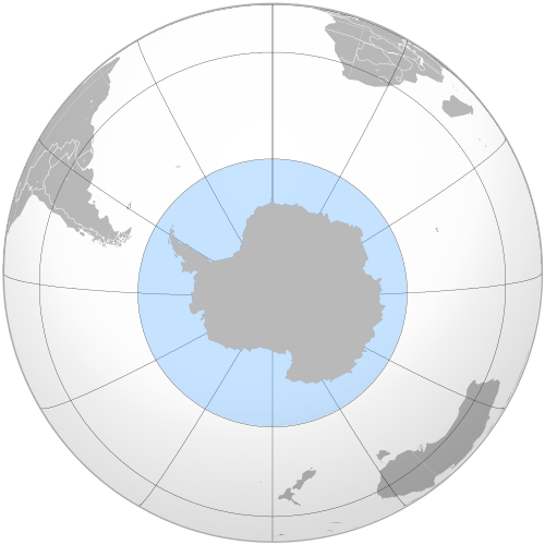

南極海は南極海とも呼ばれ、[1] [注 4]世界の海洋の最南端の海域で、一般的には南緯60度以南で南極大陸を取り囲んでいるとされています。[5]面積は20,327,000 km 2 (7,848,000 平方マイル)で、5つの主要な海洋区分の中で2番目に小さく、太平洋、大西洋、インド洋よりも小さく、北極海よりも大きいです。[6]
南極海の最大深度は、北緯60度以南と定義され、 2019年2月初旬にファイブ・ディープス遠征隊によって調査された。遠征隊のマルチビームソナーチームは、南緯60度28分46秒、西経025度32分32秒の最深地点を特定し、その深さは7,434メートル(24,390フィート)であった。遠征隊長で主任潜水艇パイロットのビクター・ベスコヴォは、 2019年2月3日に初めて海底に到達することに成功した有人潜水艇DSVリミティング・ファクターの名称に基づいて、この最深地点を「ファクトリアン・ディープ」と名付けることを提案した。 [7]
1770年代の航海で、ジェームズ・クックは、地球の南の緯度は海域に覆われていることを証明した。しかし、地理学者の間では、南極海を季節によって変動する南極収束帯で区切られた水域と定義するべきか、つまり、南極から北に流れる冷たい水が、より暖かい亜南極海と混ざり合う海域と定義するべきか、あるいはまったく定義せず、太平洋、大西洋、インド洋の南限とみなすべきか、という議論がしばしばあった。国際水路機関(IHO)は、南極海循環の重要性が完全に確認された後、最終的にこの議論に決着をつけ、南極海という用語は現在、その循環の北限より南にある水域を定義している。[9]
南極海循環は、よりよく知られている大西洋南北循環(AMOC)に次いで、地球規模の熱塩循環の後半を構成するため重要です。 [10] AMOCと同様に、南極海循環も気候変動の影響を大きく受けており、海洋の成層化が進み、[11]循環が大幅に遅くなったり、転換点を超えて完全に崩壊したりする可能性もあります。後者は、何世紀にもわたって展開される地球規模の天候と海洋生態系の機能に悪影響を及ぼします。 [12] [13]進行中の温暖化は、すでに海洋生態系に変化をもたらしています。[14]
定義と用語の使用
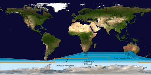
海洋と海の境界と名称は、IHOの前身である国際水路局が1919年7月24日に第1回国際会議を招集した際に国際的に合意されました。IHOはその後、1928年に初版を出した「海洋と海の境界」でこれを公表しました。初版以来、南極海の境界は次第に南に移動しており、1953年以降は公式出版物から削除され、地方水路当局が独自の境界を決定するようになりました。
IHOは2000年の改訂版で海洋とその定義を南緯60度線以南の海域に含めたが、日本海の呼称をめぐる論争など、内容の一部で行き詰まりが続いているため、正式には採用されていない。2000年のIHOの定義は2002年に草案として配布され、IHO内部の一部やCIAワールドファクトブック、メリアム・ウェブスターなどの他の組織で使用されている。[6] [15]
オーストラリア政府は、南極海はオーストラリアのすぐ南にあると考えている(を参照)。[16] [17]
ナショナルジオグラフィック協会は2021年6月にこの海洋を公式に認定した。[18] [19]以前は、他の世界の海洋とは異なる書体で描写しており、代わりに印刷地図とオンライン地図の両方で南極まで広がる太平洋、大西洋、インド洋を示していた。[20] [21]地図出版社には、Hema Maps [22]やGeoNovaなどがある。[23]
20世紀以前
.jpg/500px-A_new_map_of_Africk,_shewing_its_present_general_divisions_cheif_cities_or_towns,_rivers,_mountain_&c._(8250932292).jpg)
「南極海」は太平洋または南太平洋の古い呼び名で、スペインの探検家バスコ・ヌーニェス・デ・バルボアが北のパナマから太平洋に接近し、太平洋を発見した最初のヨーロッパ人となったときに名付けられた。[24]「南洋」はそれほど古風ではない同義語である。1745年の英国議会法により、 「アメリカの西および南の海」への北西航路の発見に賞金が与えられることが定められた。[25]
南極の未知の地域を囲む海域を「南極海」と呼ぶ著者は、さまざまな境界を用いている。ジェームズ・クックの2度目の航海の記録では、ニューカレドニアが南極海に接していることが示唆されている。[26]ピーコックの1795年地理辞典では、南極海は「アメリカとアフリカの南方」にあるとされている。 [27]ジョン・ペインは1796年に40度を北限とした。 [28] 1827年のエディンバラ地名辞典では50度とした。[29]ファミリー・マガジンは1835年に、南極圏に沿って「グレート・サザン・オーシャン」を「南極海」と「南極海」に分け、南極海の北限はホーン岬、喜望峰、ヴァン・ディーメンズ・ランド、ニュージーランド南部を結ぶ線とした。[30]
イギリスの1834年南オーストラリア法では、新しい南オーストラリア州の南限を形成する海域を「南極海」と定義した。ビクトリア植民地の1881年立法評議会法では、バーンズデールの区分の一部を「ニューサウスウェールズ州の境界に沿って南極海まで」と定義した。[31]
1928年の境界線

1928年に出版された『大洋と海の境界』の初版では、南極海は陸地を基準とした境界によって定義され、南は南極大陸、北は南アメリカ、アフリカ、オーストラリア、ニュージーランドのブロートン島とされた。
使用された詳細な陸地境界線は、チリのホーン岬から東はアフリカのアガラス岬まで、さらに東はオーストラリア本土の南岸、西オーストラリア州のルーウィン岬までである。ルーウィン岬からは、境界線はオーストラリア本土の海岸に沿って東に進み、ビクトリア州のオトウェイ岬まで続き、南に進みバス海峡を越えてキング島のウィッカム岬まで行き、キング島の西海岸に沿って進み、残りの南の道のりをバス海峡を越えてタスマニア島のグリム岬まで続く。
その後、境界線はタスマニア島の西海岸に沿って南東ケープまで南下し、その後東にニュージーランドのブロートン島まで進み、ホーン岬に戻る。[32]
1937年の境界線

南極海の北限は、1937 年に IHO が発行した『大洋と海の境界』第 2 版で南に移動されました。この版以降、海洋の北限の大部分は陸地に接しなくなりました。
第2版では、南極海は南極大陸から北にアフリカのアガラス岬(東経20度)と西オーストラリアのルーウィン岬(東経115度)の間の南緯40度まで広がり、ニュージーランドのオークランド島(東経165度または166度)と南アメリカのホーン岬(西経67度)の間の南緯55度まで広がった。 [33]
以下に詳しく説明しますが、2002 年版より前の海洋の境界は、それぞれの海洋内にある海を明確に除外していました。グレートオーストラリア湾は1928 年版では名前が付けられておらず、1937 年版では上の図のように定義されました。したがって、グレート オーストラリア湾は 1928 年に指定された旧南極海海域を包含していましたが、1937 年までに技術的には 3 つの隣接する海洋のいずれにも含まれなくなりました。
2002 年の草案版では、IHO は「海」を「海洋」内の区分として指定しているため、2002 年の条約が 1937 年に施行されていた場合、バイトは南極海内に含まれていたことになります。現在の海洋の境界と以前の海洋の境界を直接比較するには、2002 年に IHO が「海」の用語を変更したことが比較にどのような影響を与えるかを考慮するか、少なくとも認識しておく必要があります。
1953年の境界線
1953 年の第 3 版『大洋と海の限界』には南極海は登場しませんでしたが、その出版物の注記には次のように記されています。
南極海はこの刊行物から除外されている。1937年の第2版発行以来寄せられた意見の大多数は、この水域に海洋という用語を適用する正当な根拠がまったくなく、季節変化により北限を定めるのが難しいというものである。したがって、大西洋、太平洋、インド洋の境界は南の南極大陸まで延長されている。したがって、
この地域を扱う個別の刊行物を発行する水路当局は、独自の北限を決定することになる(イギリスは南緯55度を使用する)。[34] : 4
その代わりに、IHO 1953年の出版物では、大西洋、インド洋、太平洋が南に拡張され、インド洋と太平洋(第1版と第2版では1953年以前は接していなかった)がサウスイーストケープの子午線で接し、グレートオーストラリア湾とタスマン海の南限が北に移動されました。[34]
2002年草案の概略

IHOは2000年の調査で南極海の問題に再度取り組みました。68の加盟国のうち28か国が回答し、アルゼンチンを除く全加盟国が海洋学者が海流を重視していることを反映して海洋の再定義に同意しました。南極海という名称の提案は18票を獲得し、代替案の南極海を破りました。投票の半数は海洋の北限を南緯60度(この緯度には陸地が途切れない)と定義することを支持し、残りの14票は他の定義(ほとんどは南緯50度ですが、南緯35度まで北とする投票も少数ありました)に投じられました。特筆すべきことに、南極海観測システムは南緯40度よりも高い緯度からデータを収集しています。
海洋と海の境界の第4版草案は、2002年8月にIHO加盟国に配布された(2000年までの進捗状況をまとめたものであるため、「2000年版」と呼ばれることもある)。[36]世界中のさまざまな命名問題(主に日本海の命名紛争)に関連するいくつかの国の「懸念分野」のため、まだ出版されておらず、さまざまな変更が行われ、60の海に新しい名前が付けられ、出版物の名称さえ変更された。[37]オーストラリアも南極海の境界に関して留保を申し立てた。[38]事実上、南極海の境界を定めず、境界設定を地方水路当局に任せた第3版は、まだ置き換えられていない。

それにもかかわらず、第 4 版の定義は、米国( CIA ワールド ファクトブックは「南極海」を使用しているが、「南極海」内の他の新しい海名、たとえば「宇宙飛行士海」は使用していない) やメリアム ウェブスターなどの多くの国、科学者、組織によって事実上部分的に使用されている。[6] [15] [21]科学者や国家、さらには IHO の一部のメンバーによっても使用されている。[39]一部の国の水路局は独自の境界を定義しており、たとえば英国は南緯 55 度線を使用している。 [34]他の組織は、南極海のより北の境界を支持している。たとえば、ブリタニカ百科事典は、南極海は南アメリカまで北に広がっており、南極収束帯に大きな重要性を与えていると説明しているが、インド洋の説明はこれに反しており、インド洋は南極大陸まで南に広がっていると説明している。[40] [41]
ナショナルジオグラフィック協会などの他の情報源では、地図上で大西洋、太平洋、インド洋が南極まで広がっていると示されていますが、ナショナルジオグラフィックのウェブサイトの記事では南極海に言及し始めています。[21]
2002 年草案では、IHO が「海」を「大洋」の境界内の区分として定義したことにより、過去の IHO の慣行 (1928 ~ 1953 年) からの根本的な転換も見られました。IHO はこうした条約の権威と見なされることが多いのですが、この転換により、海は大洋の中に含まれるという原則をすでに採用している他の出版物 (例: CIAワールド ファクト ブック) の慣行と IHO の慣行が一致するようになりました。この慣行の違いは、隣の図の太平洋で顕著に見られます。たとえば、以前はオーストラリアとニュージーランドの間にあるタスマン海はIHO では太平洋の一部とは見なされていませんでしたが、2002 年草案では太平洋の一部となっています。
海洋の区分として新たに海域を画定したことにより、南米から南極海岸までの海域すべてを含むドレーク海峡が交差する南極海の北の境界を分断する必要がなくなり、また、南緯60度線より下に広がるスコシア海によって分断する必要もなくなった。また、新たな海域画定により、1953年版では除外されていた(1953年の地図はそこまで南に及んでいなかった)南極周辺の長年名付けられてきた海域が自動的に南極海の一部となる。

オーストラリアの立場
オーストラリアでは、地図作成の専門家は南極海を、南極大陸とオーストラリアおよびニュージーランドの南岸の間の水域全体、および他の地域では南緯60度までと定義しています。[42]タスマニア島と南オーストラリア州の海岸地図では、海域が南極海として表示されています。 [43]また、西オーストラリア州のルーウィン岬は、インド洋と南洋が出会う地点として説明されています。[44]
探検の歴史
知られざる南の地
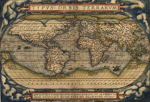
南極海の探検は、地球の極南にユーラシア大陸と北アフリカの北の土地を「均衡させる」広大な大陸があるというプトレマイオスの時代から存在していたという信念に触発されたものである。 1487年にバルトロメウ・ディアスが喜望峰を回ったことで、探検家たちは初めて南極の寒さに触れることになり、アフリカと南極の土地が存在するかもしれない場所を隔てる海があることが証明された。[45] 1520年にマゼラン海峡を通過したフェルディナンド・マゼランは、南のティエラ・デル・フエゴ島がこの未知の南の土地の延長であると想定した。 1564年、アブラハム・オルテリウスは最初の地図「Typus Orbis Terrarum」を出版した。これは8枚の葉の壁掛け世界地図であり、その中で彼はレギオ・パタリスとロカチをテラ・アウストラリスの北の延長としてニューギニアまで達すると記した。[46] [47]
ヨーロッパの地理学者は地球儀上でティエラ・デル・フエゴの海岸とニューギニアの海岸を結び付け続け、南大西洋、南インド洋、太平洋の広大な未知の空間に想像力を駆使して、熱帯地方にまで広がる広大な大陸、テラ・アウストラリス・インコグニタ(「未知の南の国」)の輪郭を描きました。この偉大な南の国を探すことは、16世紀から17世紀初頭にかけての探検家の主な動機でした。[45]
1603年に南緯64度以北に「雪に覆われた山々」を目撃したと主張したスペイン人の ガブリエル・デ・カスティーリャは、当時は無視されていたものの、南極大陸を発見した最初の探検家として認められている。
1606年、ペドロ・フェルナンデス・デ・キロスは、オーストラリア・デル・エスピリトゥサント(ニューヘブリディーズ諸島)で発見したすべての土地と、後に「北極点まで」発見した土地をスペイン王のために所有した。[45]
フランシス・ドレークは、彼以前のスペインの探検家たちと同様に、ティエラ・デル・フエゴの南に開通した海峡があるのではないかと推測していた。ウィレム・スハウテンとジェイコブ・ル・メールが1615年にティエラ・デル・フエゴの南端を発見し、ホーン岬と名付けたとき、彼らはティエラ・デル・フエゴ諸島が小さい範囲にあり、それまで考えられていたように南の陸地とつながっていないことを証明した。その後、1642年にアベル・タスマンは、ニューホランド(オーストラリア)でさえ、連続した南の大陸から海で隔てられていることを実証した。[45]
南極収束線の南

1675年のアンソニー・デ・ラ・ロシェによるサウスジョージア島への訪問は、南極収束線より南、すなわち南極海/南極の初めての陸地発見となった。 [48] [49]航海の直後、地図製作者は発見者を称えて「ロシェ島」を描き始めた。ジェームズ・クックは1775年に島を調査し地図を作成した際にラ・ロシェの発見を知っていた。[50]
エドモンド・ハレーは、 1700年1月にパラモア 号で南大西洋の磁気調査のため航海中に南緯52度で流氷に遭遇したが、その緯度(サウスジョージア島北岸沖140マイル[230km]に到達)が彼の最南端であった。フランス海軍士官ジャン=バティスト・シャルル・ブーヴェ・ド・ロジエは、半ば伝説的な「シュー・ド・ゴネヴィル」が描写した「南の国」を発見しようと懸命に努力し、その結果、南緯54度10分にブーヴェ島を発見し、 1730年には南緯55度近くの氷に覆われた海域48度の経度を航海した。[45]
1771年、イヴ・ジョセフ・ケルゲレンは、モーリシャスから南へ「非常に大きな大陸」を探すよう指示されてフランスから出航した。彼は南緯50度の土地にたどり着き、そこを南フランスと名付け、南大陸の中央部であると信じた。彼は新しい土地の探検を完了するために再び派遣され、そこは単に人が住めない島であることが判明した。彼はその島を荒廃の島と改名したが、最終的には彼の名にちなんで名付けられた。[45]
南極圏の南

未発見の大陸への執着は、アレクサンダー・ダルリンプルの頭脳の中で頂点に達しました。ダルリンプルは優秀でありながら気まぐれな水路測量士で、1769年に王立協会からタヒチへの金星の太陽面通過探検隊の指揮官に指名されました。この探検隊の指揮は海軍本部からジェームズ・クック船長に与えられました。1772年、自らが指揮する462トンの船レゾリューション号と、トビアス・ファーノー船長の指揮する336トンのアドベンチャー号を率いて出航したクックは、まずブーベ島を探しましたが見つからず、次に南緯58度で西に20度経度、次に南緯60度以南の大部分を30度東に航海しました。南緯60度は、それまでどの船も自発的に進入したことのない低い南緯でした。 1773年1月17日、歴史上初めて南極圏を横断し、2隻の船は南緯67度15分、東経39度35分に到達したが、そこで氷によって進路が阻まれた。[45]

クックはその後北に進路を変え、ケープタウンで発見の知らせを受け取っていたフランス領南方諸島および南極諸島を探すことになったが、ケルゲレン島で大まかに経度を測定したため、指定された緯度に到達したとき東に10度行き過ぎており、発見できなかった。再び南に進路を変え、南緯61度52分、東経95度で氷に阻まれ、南緯60度から東経147度にかけてのほぼ緯線に沿って東進を続けた。3月16日、冬が近づいたため、休息のためニュージーランドおよび太平洋の熱帯諸島へ北上した。1773年11月、クックはアドベンチャー号と別れてニュージーランドを出発し、南緯60度、西経177度に到達し、そこから流氷の許す限り南を進みながら東進した。 12月20日に南極圏を越え、クックは3日間南に留まり、南緯67度31分に到達した後、西経135度で再び北に立たざるを得なかった。[45]
南緯47度50分までの長い迂回により、ニュージーランドとティエラ・デル・フエゴの間には陸地がつながっていないことがわかった。再び南に転じ、クックは西経109度30分で三度目の南極圏を越えたが、その4日後、南緯71度10分、西経106度54分で再び氷に阻まれた。1774年1月30日に到達したこの地点は、18世紀に到達した最南端であった。東に大きく迂回してほぼ南アメリカの海岸まで行き、遠征隊は補給のためタヒチに戻った。1774年11月、クックはニュージーランドを出発し、南太平洋を横断したが、南緯53度から57度からティエラ・デル・フエゴの間に陸地は見えなかった。その後、12月29日にホーン岬を通過し、ロシェ島を再発見してジョージア島と改名し、南大西洋を横断して北緯55度から60度の喜望峰に向かう前に、それまで見た唯一の氷に覆われた陸地であるサウスサンドイッチ諸島(彼によってサンドイッチランドと名付けられた)を発見した。こうして彼は、南極大陸が居住可能であるという神話を打ち砕き、将来の南極探検への道を開いた。クックが発見した最も南の陸地は北緯60度線の温帯側にあり、彼はそれより南に陸地があれば、事実上アクセス不可能で経済的価値もないと確信していた。[45]
ホーン岬を回った航海者たちは、しばしば逆風に遭遇し、雪の降る空と氷に覆われた海へと南へと流された。しかし、確認できる限りでは、1770 年以前に南極圏に到達した者はおらず、到達したとしてもそれを知っていた者もいない。
1822年から1824年にかけての航海で、ジェームズ・ウェッデルは160トンのブリッグ船 ジェーン号を指揮し、マシュー・ブリスベンが船長を務める2番船ボーフォイ号を従えていた。2隻は一緒にサウス・オークニー諸島へ航海したが、アザラシ猟は期待外れだった。彼らはより良いアザラシ猟場が見つかることを期待して南に向かった。その季節は例年になく穏やかで平穏であり、1823年2月20日、2隻の船は南緯74度15分、西経34度16分45秒の地点に到達した。これは、その時点ではどの船も到達したことのない南端の地点だった。氷山がいくつか見えたものの、陸地はまだ見えず、ウェッデルは海が南極まで続いていると推測した。あと2日航海すればコーツ・ランド(ウェッデル海の東)に着くはずだったが、ウェッデルは引き返すことにした。[52]
陸地の最初の発見

南緯60度線より南の最初の陸地は、 1819年2月19日にリビングストン島を目撃したイギリス人ウィリアム ・スミスによって発見されました。数か月後、スミスはサウス・シェトランド諸島の他の島々を探検するために戻り、キング・ジョージ島に上陸し、新しい領土をイギリスの領有権を主張しました。
その間に、スペイン海軍の船サンテルモ号は、ホーン岬を渡ろうとした際に 1819 年 9 月に沈没しました。その残骸の一部は、数か月後にリビングストン島(サウスシェトランド諸島)の北岸でアザラシ猟師によって発見されました。生存者がこれらの南極諸島に最初に足を踏み入れたかどうかは不明です。
南極大陸の最初の目撃は、正確には一人の人物によるものとは言い切れません。3人に絞り込むことができます。さまざまな情報源によると、[53] [54] [55] 3人の男性が数日または数ヶ月以内に棚氷または大陸を目撃しました。ロシア帝国海軍の艦長ファビアン・ゴットリープ・フォン・ベリングスハウゼン、イギリス海軍の艦長エドワード・ブランスフィールド、コネチカット州ストーニントン出身のアメリカ人船員ナサニエル・パーマーです。フォン・ベリングスハウゼンとラザレフが率いたボストーク号とミールヌイ号の遠征隊がプリンセス・マーサ海岸から32km (20マイル) 以内の地点に到達し、 69°21′28″S 2°14′50″W / 69.35778°S 2.24722°W / -69.35778; -2.24722 [56]にフィンブル棚氷として知られるようになった棚氷を記録したことは確かである。1820年1月30日、ブランスフィールドは南極大陸の最北端であるトリニティ半島を視認し、パーマーは1820年11月にトリニティ半島の南の地域で大陸を視認した。フォン・ベリングスハウゼンの遠征隊は、円の南側で発見された最初の島々であるピーター1世島とアレクサンダー1世島も発見した。
南極大陸と南アメリカ、アフリカ、オーストラリア大陸の間にある南極海を示す歴史地図
-
 フランスの地図製作者アラン・マネソン・マレが1683年に著した、著書『宇宙の記述』に掲載された地図。ティエラ・デル・フエゴが南極大陸とつながっていたと考えられていた時代の、大西洋と太平洋の両方の下に海があったことが示されています。海はフェルディナンド・マゼランにちなんでMer Magellaniqueと名付けられています。
 -
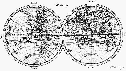
 サミュエル・ダンの 1794 年の『世界一般地図』または『地球儀』には、南極海(ただし、これは現在では南大西洋と呼ばれる地域を指します) と南氷洋が示されています。
 -
 1806 年に彫刻家ジョン・ケアリーが著した『最新の権威によるアジアの新地図』には、インド洋とオーストラリアの南に南極海が広がっていることが示されています。
 -
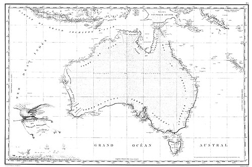 1811 年のフレシネ地図– 1800 年から 1803 年にかけてのフランスのボーダンのオーストラリア遠征によって作成されたもので、オーストラリアの完全な地図としては初めて出版されました。この地図では、フランス語でオーストラリアの真下の海をGrand Océan Austral (「偉大な南の海」) と名付けています。
 -
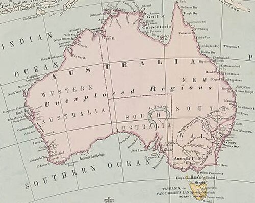 1863 年のオーストラリアの地図には、オーストラリアのすぐ南に南極海が広がっていることが示されています。
 -
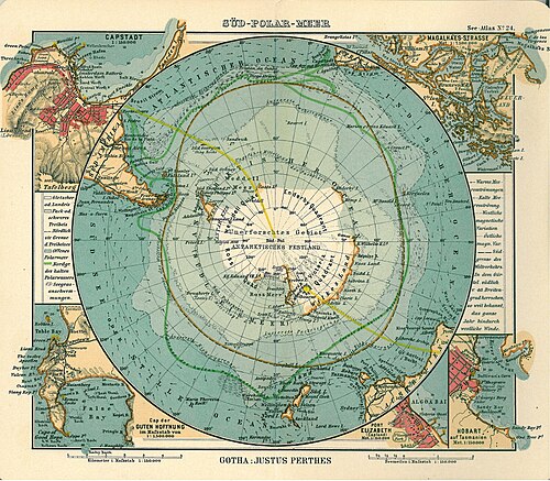 1906 年にドイツの出版者ユストゥス・ペルテスが作成した地図。南極大陸が南極海 (南極海)に囲まれている様子が示されています。
 -
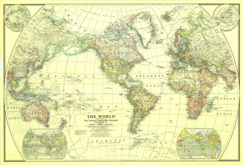 ナショナル ジオグラフィック協会が 1922 年に作成した南極海 (南極) を示す世界地図。
.jpg/500px-Continent_m%C3%A9ridional_austral_ou_Antarctique_(Description_de_l'Univers,_V,_pl._107).jpg)

南極探検


1839年12月、アメリカ海軍が指揮した1838年から1842年にかけてのアメリカ探検遠征(「ウィルクス遠征」と呼ばれることもある)の一環として、スループ船USS ヴィンセンズとUSS ピーコック、ブリッグ船USS ポーパス、フルリグ船リリーフ、2隻のスクーナー船シーガルとUSS フライングフィッシュに乗って、オーストラリアのシドニーから遠征隊が出航した。彼らは当時南極海と呼ばれていた海域に航海し、1840年1月25日に「バレニー諸島の西に南極大陸」を発見したと報告した。南極大陸のその部分は後に「ウィルクスランド」と名付けられ、今日までその名前が続いている。
探検家ジェームズ・クラーク・ロスは、現在ロス海として知られる海域を通過し、ロス島(どちらも彼の名にちなんで名付けられた)を1841年に発見した。彼は、後にロス棚氷と名付けられた巨大な氷壁に沿って航海した。エレバス山とテラー山は、彼の探検隊の2隻の船、 HMS エレバスとHMS テラーにちなんで名付けられた。[57]

1914年、アーネスト・シャクルトン率いる帝国南極横断遠征隊は南極点を経由して大陸を横断しようとしたが、彼らの船「エンデュアランス号」は上陸する前に流氷に閉じ込められ、押しつぶされた。遠征隊のメンバーは流氷の上をそりでエレファント島まで壮大な旅を経て生き延びた。その後、シャクルトンと他の5人はジェームズ・ケアード号という名のオープンボートで南極海を横断し、サウスジョージア島を歩いてグリトビケン捕鯨基地に警報を発した。
1946年、アメリカ海軍のリチャード・E・バード少将と4,700人以上の軍人が、ハイジャンプ作戦と呼ばれる遠征で南極を訪れた。一般には科学的調査ミッションとして報告されたが、詳細は秘密にされ、実際には軍の訓練または試験ミッションだった可能性がある。この遠征は、軍事計画の観点からも科学的計画の観点からも、非常に迅速に編成された。このグループには、航空母艦、潜水艦、軍事支援船、攻撃部隊、軍用車両など、異常に大量の軍事装備が含まれていた。この遠征は8か月間続く予定だったが、わずか2か月で予想外に中止された。バード提督の日記のいくつかの風変わりな記述を除いて、早期終了の本当の理由は公式には明らかにされていない。
バードの副長フィン・ロンネ大尉は、海軍の支援を受け、3機の飛行機と犬を連れて、1947年から1948年にかけて自身の探検隊を率いて南極に戻った。彼は、南極大陸が2つに分かれているという考えを否定し、東南極と西南極は1つの大陸であり、ウェッデル海とロス海はつながっていないことを証明した。[58] 探検隊はパーマーランドとウェッデル海の海岸線の大部分を探検して地図を作成し、妻ジャッキー・ロンネにちなんでロンネ棚氷と名付けた。[59]彼はスキーと犬ぞりで3,600マイル (5,790 km) を移動したが、これは歴史上他のどの探検家よりも長い距離である。[60]ロンネ南極調査探検隊は、世界で最後に残された未知の海岸線を発見して地図に記した、女性が参加した初の南極探検隊となった。[61]
大西洋条約機構後の条約
南極条約は1959年 12 月 1 日に調印され、1961 年 6 月 23 日に発効しました。この条約では、他の規定の中でも、南極における軍事活動を科学研究の支援に限定しています。
南極まで単独で航海した最初の人物は、1972年に全長10メートル(30フィート)の鋼鉄製スループ船「アイスバード」に乗ったニュージーランド人のデイビッド・ヘンリー・ルイスでした。
1978年1月7日、ホープ湾の近くでエミリオ・マルコス・デ・パルマという名の赤ちゃんが誕生し、この大陸で生まれた最初の赤ちゃんとなった。彼は歴史上誰よりも南で生まれた赤ちゃんでもある。[62]
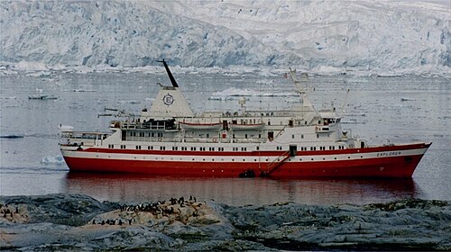
エクスプローラー号 は、スウェーデンの探検家ラース=エリック・リンドブラッドが運航していたクルーズ船である。観察者は、エクスプローラー号の1969年の南極探検クルーズが、今日の[いつ? ]その地域の海上観光の先駆けであると指摘している。[63] [64]エクスプローラーは、南極海の氷海を航行するために特別に使用された最初のクルーズ船であり、そこで沈没した最初の船でもある[65]。 2007年11月23日、同船は氷であると報告された未確認の水中物体に衝突し、船体に10×4インチ(25×10cm)の裂傷を負った。[66]エクスプローラーは、通常は嵐が吹き荒れる南極海のサウス・シェトランド諸島付近で浸水した後、2007年11月23日早朝に放棄された。 [67]エクスプローラーはチリ海軍によって、およそ南緯62度24分、西経57度16分、[68]の水深約600メートルに沈没したことが確認された。 [69]
イギリスのエンジニア、リチャード・ジェンキンスは無人セイルドローン[70]を設計し、2019年8月3日に196日間の航海を経て南極海の初の自律周回航海を完了した[71] 。
南極海における初の完全人力探検は、2019年12月25日に、船長フィアン・ポール(アイスランド)、一等航海士コリン・オブラディ(米国)、アンドリュー・タウン(米国)、キャメロン・ベラミー(南アフリカ)、ジェイミー・ダグラス・ハミルトン(英国)、ジョン・ピーターセン(米国)からなる漕ぎ手チームによって達成されました。[72]
地理
地質学的に最も新しい海洋である南極海は、およそ3000万年前に南極大陸と南アメリカ大陸が離れ、ドレーク海峡が開いたときに形成されました。大陸の分離により、南極周極海流が形成されました。
南極海の北限は南緯60度であり、その最大の境界である北限が陸地に接していない(『大洋と海の限界』の初版ではそうであったように)という点で他の海洋と異なっている。その代わり、北限は大西洋、インド洋、太平洋である。
南極海を別の海とみなす理由の 1 つは、南極海の水の多くが他の海の水と異なるという事実です。南極の周りを循環する南極周極海流により、水は南極海の周りをかなり速く移動します。たとえばニュージーランドの南にある南極海の水は、太平洋の水よりも、南アメリカ南部の南極海の水によく似ています。
南極海の典型的な水深は、その大半で 4,000 ~ 5,000 メートル (13,000 ~ 16,000 フィート) で、浅瀬の部分はごくわずかです。南極海の最大水深は、サウスサンドイッチ海溝の南端、南緯 60 度、西経 024 度で 7,236 メートル (23,740 フィート) です。南極大陸棚は一般に狭く、異常に深く、その端は深さ 800 メートル (2,600 フィート) に達しますが、世界平均は 133 メートル (436 フィート) です。
春分から秋分まで、太陽の季節的な影響に合わせて、南極の氷床面積は、3 月の平均最小値 260 万平方キロメートル (1.0 × 10 6 平方マイル) から、9 月の約 1,880 万平方キロメートル (7.3 × 10 6 平方マイル) まで変動し、面積は 7 倍以上に増加します。
区分

海洋の区分は、「海」、「海峡」、「湾」、「水路」、「湾岸」などの地理的特徴です。南極海には、承認されなかった IHO 出版物「海洋と海の境界」の 2002 年草案第 4 版で定義された多くの区分があります。時計回りに並べると、次のようになります (セクター付き)。
- ウェッデル海 (西経57°18' – 東経12°16')
- キングホーコン7世の海[注5] (西経20度 – 東経45度)
- ラザレフ海 (東経 0° – 14°)
- ライザー・ラーセン海 (東経14°~30°)
- コスモノート海 (東経30度~50度)
- 協力海 (東経59°34' – 85°)
- デイビス海 (東経82度~96度)
- モーソン海 (95°45' – 113°E)
- デュモン・デュルヴィル海 (東経140度)
- ソモフ海 (東経150度~170度)
- ロス海 (東経166度~西経155度)
- アムンゼン海 (102°20′ – 126°W)
- ベリングスハウゼン海 (西経57°18' – 102°20')
- ドレーク海峡の一部[注 6] (西経54° – 68°)
- ブランスフィールド海峡 (西経54°~62°)
- スコシア海の一部[注7] (西経26度30分~65度)
2002年にロシアが提案した「宇宙飛行士の海」、「協力海」、「ソモフ海(1950年代半ばのロシア極地探検家)の海」など、現在も有効な1953年のIHO文書にはこれらの海域は含まれていない。 [34]これらの海域の名前の由来は、主に1962年以降である。主要な地理学の権威や地図帳では、後者の3つの名前は使用されていない。これには、米国ナショナルジオグラフィック協会の2014年版世界地図帳第10版や、英国タイムズ紙の世界地図帳第12版が含まれるが、ソ連とロシアが発行した地図では使用されている。[73] [74]
最大の海
上位の大きな海: [75] [76] [77]
- ウェッデル海– 2,800,000 km 2 (1,100,000 平方マイル)
- ソモフ海– 1,150,000 km 2 (440,000 平方マイル)
- ライザー・ラーセン海– 1,138,000 km 2 (439,000 平方マイル)
- ラザレフ海– 929,000 km 2 (359,000 平方マイル)
- スコシア海– 900,000 km 2 (350,000 平方マイル)
- コスモノート海– 699,000 km 2 (270,000 平方マイル)
- ロス海– 637,000 km 2 (246,000 平方マイル)
- ベリングスハウゼン海– 487,000 km 2 (188,000 平方マイル)
- モーソン海– 333,000 km 2 (129,000 平方マイル)
- 協力海– 258,000 km 2 (100,000平方マイル)
- アムンゼン海– 98,000 km 2 (38,000 平方マイル)
- デイビス海– 21,000 km 2 (8,100 平方マイル)
- デュルヴィル海
- ホーコン7世海
天然資源

南極海の大陸縁辺部には、おそらく大規模な、おそらくは巨大な油田とガス田が存在する。また、堆積過程における重力分離によって形成された、金などの貴重な鉱物の集積である砂鉱床も南極海に存在すると予想されている。[5]
マンガン団塊は南極海に存在すると予想されている。マンガン団塊は海底の岩石団塊で、核の周りに鉄とマンガンの水酸化物の同心円状の層が形成されたものである。核は顕微鏡でしか見えないほど小さく、結晶化によって完全にマンガン鉱物に変化することもある。多金属団塊の潜在的採掘への関心は、1960年代から1970年代にかけて、有望な採掘コンソーシアムの間で活発な活動を引き起こした。[5]
南極海で毎年形成される氷山には、地球上の全人類の数か月分の需要を満たすのに十分な量の淡水が含まれています。数十年にわたって、南極海の氷山をオーストラリアなどのより乾燥した北部地域まで曳航して採取するという提案がなされてきましたが、まだ実現可能でも成功でもありません。[78]
自然災害
.jpg/500px-Burton_Island,_Atka,_and_Glacier_push_iceberg_in_McMurdo_Sound_(827218l).jpg)
氷山は、一年中いつでも海中に発生する可能性があります。氷山によっては喫水が数百メートルに達するものもありますが、小さな氷山、氷山の破片、海氷 (通常 0.5 ~ 1 メートルの厚さ) も船舶にとって問題となります。大陸棚の奥深くには、短い距離で大きく変化する氷河堆積物の底があります。
船乗りたちは、南緯40 度から70 度の緯度を「狂乱の 40 度」、「激怒の 50 度」、「悲鳴の 60 度」と呼んでいます。これは、陸地が邪魔することなく地球全体を吹き抜ける風によって強風と大波が発生するためです。特に 5 月から 10 月にかけては、氷山によってこの地域はさらに危険になります。この地域は遠隔地であるため、捜索救助の手段がほとんどありません。
海洋物理学
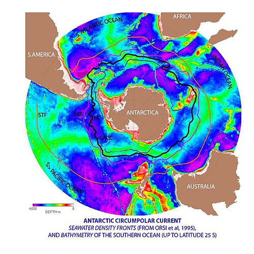
南極周極流と南極収束
南極海は世界で2番目に小さい海であるが、独特で非常にエネルギーの高い南極周極海流が絶えず東へ流れており、互いに追いかけたり合流したりしている。長さは21,000 km (13,000 mi)で、世界最長の海流を構成し、毎秒1億3000万立方メートル (4.6 × 10 9 cu ft/s) の水を輸送している。これは世界中の川の流量の100倍にあたる。[79]
南極大陸の海岸沿いでは、南極海に南半球の他の海域では生成されない種類の水塊を生成するいくつかのプロセスが進行しています。その 1 つが南極底層水で、これは海氷の下に形成される非常に冷たく、塩分濃度が高く、密度の高い水です。もう 1 つは南極底層水と北大西洋深層水が混ざった周極深層水です。
周極海流に関連して、南極大陸を取り囲む南極収束流があります。ここで、北に流れる冷たい南極海水が比較的暖かい亜南極海水と出会い、南極海水は主に亜南極海水の下に沈み、関連する混合帯と湧昇帯により栄養分が非常に豊富な帯が形成されます。これらは、関連するカイアシ類や南極オキアミを含む高レベルの植物プランクトンを育み、その結果、魚、クジラ、アザラシ、ペンギン、アホウドリ、その他多くの種を支える食物連鎖を形成します。[80]
南極収束帯は、南極海の北限を最も自然に定義するものだと考えられています。

南極海の湧昇
湧昇
大規模な湧昇は南極海で見られる。強い西風(東風)が南極大陸の周りを吹き、大量の水が北へ流れる。これは実際には沿岸湧昇の一種である。南アメリカと南極半島の先端の間の開いた緯度帯には大陸がないため、この水の一部は深海から汲み上げられる。多くの数値モデルと観測統合では、南極海の湧昇は深海の高密度水が表面に運ばれる主な手段を表している。風による浅い湧昇は、南北アメリカの西海岸、アフリカ北西部と南西部、オーストラリア南西部と南東部でも見られ、すべて海洋亜熱帯高圧循環に関連している。
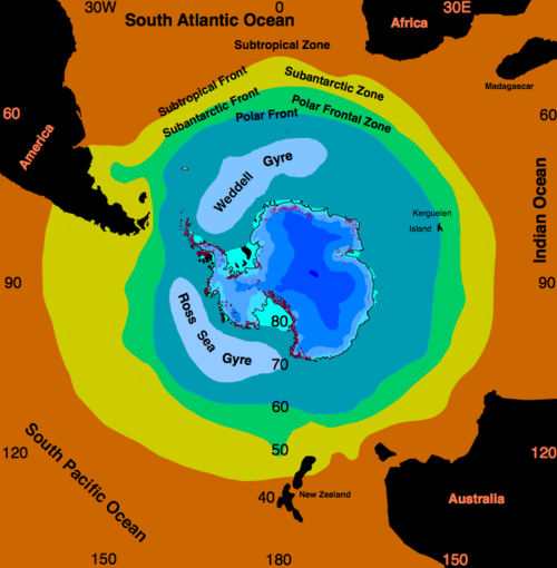
ロス環流とウェッデル環流
ロス環流とウェッデル環流は、南極海に存在する 2 つの環流です。この環流はそれぞれロス海とウェッデル海にあり、どちらも時計回りに回転します。この環流は、南極周極流と南極大陸棚の相互作用によって形成されます。
ロス環流の中央部では海氷が残存していることが観察されている。 [81] 1950年代以降、地球温暖化によりロス環流の水の塩分濃度が若干低下したという証拠がある。 [82]
南半球では左方向にコリオリの効果が働き、その結果としてウェッデル環流の中心から離れた方向にエクマン輸送が起こるため、これらの地域では冷たく栄養分に富んだ水が湧き上がり、非常に生産的です。

観察
南極海の観測は、南極海観測システム(SOOS)を通じて調整されています。[83] [84]これにより、水路測定や海流など、過去数十年間にこの地域で収集されたデータの大部分のメタデータにアクセスできます。データ提供は、南緯40度以南の海域の 重要な海洋変数(EOV)[85]に関連する記録に重点を置くように設定されています。
気候
海水温は−2~10℃(28~50℉)の範囲で変化する。サイクロン嵐は大陸の周りを東に移動し、氷と外洋の温度差により頻繁に激しくなる。南緯40度から南極圏にかけての海は、地球上で最も平均風速が強い。[86]冬には、太平洋では南緯65度まで、大西洋では南緯55度まで海が凍り、表面温度が0℃を大きく下回る。一部の沿岸部では、内陸部からの持続的な強い排水風により、冬の間中海岸線は氷に覆われない。

変化
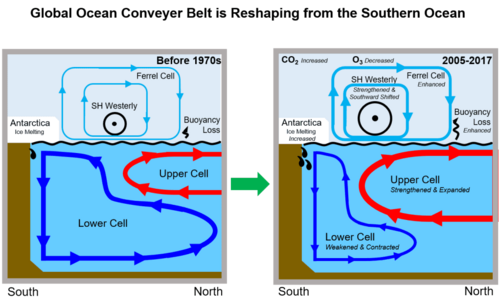
南極海循環(南極子午面循環(SMOC)[87]または南極子午面循環とも呼ばれる)は、地球全体の海洋のさまざまな水域を結ぶ地球規模の熱塩循環の南半分です。そのよりよく知られている北半分は、大西洋子午面循環(AMOC)です。この循環は、特定の海流が暖かく、酸素を豊富に含み、栄養分の少ない水を深海に送り込み(沈降)、冷たく、酸素が限られ、栄養分が豊富な水が特定の地点で上昇(湧昇)するときに機能します。熱塩循環は、大量の温水と冷水を地球全体に輸送するだけでなく、溶存酸素、溶存有機炭素、鉄などの他の栄養素も輸送します。[88]したがって、循環の両半分は地球のエネルギー収支と海洋炭素循環に大きな影響を与え、地球の気候システムで重要な役割を果たします。[89] [90]

人為的な温室効果ガスの排出が温暖化の増加を引き起こすため、気候変動が海洋に及ぼす最も顕著な影響の一つは海洋熱量の増加であり、これは1971年以降の地球全体の温暖化の90%以上を占めています。 [95] 2005年以降、この増加の67%から98%が南極海で発生しています。[96]西南極では、海洋上層の温度が1955年以降1℃(1.8℉)上昇しており、南極周極流(ACC)も世界平均よりも速いペースで温暖化しています。[97]この温暖化は、循環を形成する暖かい水塊と冷たい水塊の流れに直接影響を及ぼし、南半球の海氷(反射率が高く、地球表面のアルベドを高める)や南極の棚氷と周辺の氷河の質量バランスにも悪影響を及ぼします。[98]これらの理由から、気候モデルは一貫して、地球温暖化が2°C(3.6°F)に達する年(温室効果ガスの排出量が大幅に削減されていないすべての気候変動シナリオで避けられない)は、排出量自体以外のどの要因よりも循環の状態に依存することを示しています。[99]
この海水の温暖化が進むと、南極の氷の損失が増加し、また、年間11000億〜15000億トンの割合で、より多くの淡水融解水が生成されます。 [98] : 1240 南極の氷床からのこの融解水は、その後、南極海に再び混ざり合い、その水を淡水にします。[100]この南極海の淡水化により、層の成層化と安定化が促進され、[101] [98] : 1240 これは、南極海の循環の長期的特性に最も大きな影響を及ぼします。[102]南極海のこれらの変化により、上層細胞の循環が加速し、主要な海流の流れが加速します。[103]一方、下層細胞の循環は、塩分濃度の高い南極の底部水に依存しているために遅くなります。2010年代の回復は限られているものの、すでに淡水化によって明らかに弱まっているようです。[104] [105] [106] [98] : 1240 1970年代以降、上層氷床は3~4スベルドラップ(Sv; 毎秒100万立方メートルの流量を表す)、つまりその流量の50~60%増加し、下層氷床は同量弱まったが、その体積が大きいため、これらの変化は10~20%の弱体化を示している。[107] [89]しかし、これらは完全に気候変動によって引き起こされたわけではなく、 10年規模太平洋振動の自然周期も重要な役割を果たしていた。[108] [109]

同様のプロセスが大西洋南北循環(AMOC)でも起こっており、これもまた海洋温暖化と減少するグリーンランド氷床からの融解水の流れの影響を受けています。[111]両方の循環が温暖化と淡水化の増加に応じて単に弱まり続けるのではなく、最終的には完全に非常に弱い状態に崩壊し、元に戻すことが困難になり、気候システムの転換点の例となる可能性があります。[99]現在よりも暖かい時期と寒い時期の両方で、過去における南北循環が現在よりも大幅に弱かったことを示す古気候学的証拠があります。 [110]しかし、南半球には世界人口の10%しか住んでおらず、南極海南極循環は歴史的にAMOCほど注目されてきませんでした。その結果、AMOCの崩壊につながる地球温暖化の正確なレベル、そのような崩壊が起こる可能性のある時間枠、それが引き起こす地域的な影響を推定する研究が複数行われている一方で、2020年代初頭の時点で南極海の循環の崩壊に関する研究ははるかに少ない。その崩壊は1.7℃(3.1℉)から3℃(5.4℉)の間で起こる可能性があるという示唆があるが、この推定は他の多くの転換点よりもはるかに不確実である。[99]
南極海の循環崩壊の影響もあまり詳しく研究されていないが、科学者らは数世紀にわたって影響が現れると予想している。注目すべき例としては、南極の底層水からの栄養分の喪失が海洋の生産性を低下させ、最終的には南極海の漁業の状態を悪化させ、一部の魚種の絶滅や一部の海洋生態系の崩壊につながる可能性があることが挙げられる。[112]海洋生産性の低下は、海洋が吸収する炭素量も減少する(ただし21世紀中ではない[93])ことを意味し、人為的排出に対する最終的な長期温暖化を加速させる(したがって全体的な気候感度を高める)可能性があり、地質学的時間スケールで温暖化が衰退し始めるまでの期間を延長する可能性がある。[87]また、オーストラリアなどの南半球の国では降水量が減少し、北半球ではそれに応じて増加すると予想されている。しかし、AMOCの減少や完全な崩壊は、類似しているが反対の影響をもたらし、両者はある程度まで相殺し合うだろう。両方の影響は、気候変動が水循環に及ぼす他の影響や、気候変動が漁業に及ぼす影響と並行して発生するだろう。[112]生物多様性

動物
南極海にはさまざまな海洋動物が存在し、直接的または間接的に植物プランクトンに依存しています。南極の海洋生物には、ペンギン、シロナガスクジラ、シャチ、巨大イカ、オットセイなどがいます。コウテイペンギンは冬季に南極で繁殖する唯一のペンギンで、アデリーペンギンは他のどのペンギンよりも南で繁殖します。イワトビペンギンは目の周りに特徴的な羽毛があり、精巧なまつげのように見えます。キングペンギン、ヒゲペンギン、ジェンツーペンギンも南極で繁殖します。
ナンキョクオットセイは、 18世紀から19世紀にかけて、米国や英国のアザラシ猟師によって毛皮目的で大量に狩猟された。ウェッデルアザラシは「真のアザラシ」であり、ウェッデル海での英国アザラシ猟遠征隊の指揮官、サー・ジェームズ・ウェッデルにちなんで名付けられた。大きな群れを形成するナンキョクオキアミは、南極海の生態系の要となる種であり、クジラ、アザラシ、ヒョウアザラシ、オットセイ、イカ、シラウオ、ペンギン、アホウドリ、その他多くの鳥類にとって重要な食料生物である。 [113]
海底の底生生物群は多様で密度が高く、1平方メートル(10.8平方フィート)あたり最大155,000匹の動物が生息している。南極の海底環境はどこも非常に似ているため、大陸のいたるところで数百種の生物が見つかっており、これほど大規模な生物群としては他に例を見ないほど広範囲に分布している。深海で巨大化する生物は、こうした動物に多い。[114]
国際極年中に実施され、約 500 人の研究者が参加した海洋生物の調査が 2010 年に発表されました。この研究は、地球規模の海洋生物調査(CoML) の一環であり、注目すべき発見がいくつか明らかになりました。両極地域には 235 種を超える海洋生物が生息しており、12,000 km (7,500 マイル) の距離を橋渡ししています。一部のクジラ目や鳥などの大型動物は、毎年往復しています。さらに驚くべきは、両極の海に生息する、マッドワーム、ナマコ、自由に泳ぐ巻貝などの小型生物です。これらの生物の分布には、さまざまな要因が関係していると考えられます。たとえば、極地と赤道の深海の温度は 5 °C (9.0 °F) 以内でほぼ均一であり、卵や幼生を運ぶ主要な海流システムや海洋コンベア ベルトがその要因です。[115]南極と北極に生息する小型海洋動物は、一般的には同じものと考えられているが、それぞれの個体群のより詳細な研究により、しばしば(常にではないが)違いが明らかになり、単一の二極種ではなく、密接に関連した隠蔽種であることが示された。[116] [117] [118]
鳥類
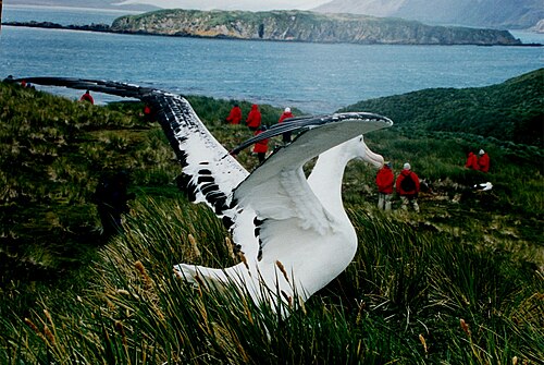
南極大陸本土の岩の多い海岸とその沖合の島々は、毎年春に1億羽以上の鳥の巣作り場所となっている。これらの巣作り鳥には、アホウドリ、ミズナギドリ、トウゾクカモメ、カモメ、アジサシなどの種が含まれる。[119]昆虫食のサウスジョージアヒバリはサウスジョージア島とその周辺の小さな島々の固有種である。淡水ガモはサウスジョージア島とケルゲレン諸島に生息している。[120]
飛べないペンギンはすべて南半球に生息しており、最も密集しているのは南極大陸とその周辺です。18種のペンギンのうち4種は本土とその近くの沖合の島々に生息し、繁殖しています。他の4種は亜南極の島々に生息しています。[121] 皇帝ペンギンは4層の羽毛が重なり合って温かさを保っています。冬に繁殖する唯一の南極の動物です。[122]
魚
南極海には比較的少数の科に少数の魚種しか生息していない。最も種の豊富な科はウナギウオ科(Liparidae)で、次いでタラの白魚科(Nototheniidae)[123]とウナギウオ科(Zoarcidae)である。ウナギウオ科、ウナギウオ科、ノトテニア類(タラの白魚と他のいくつかの科を含む)を合わせると、南極海で記載されている320種を超える魚種のほぼ9/10を占める(この地域にはウナギウオを中心に記載されていない種も数十種生息している)。[ 124 ]南極海のウナギウオは一般に深海に生息し、白魚は浅い海域にも生息する。[123]
アイスフィッシュ
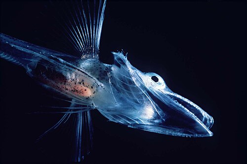
ノトテニイデ科(Nototheniidae)は、他のいくつかの科とともに、ノトテニイオイデイ亜目に属し、総称してアイスフィッシュと呼ばれることもあります。この亜目には、血液や組織に不凍タンパク質を持つ種が多く含まれており、0℃(32℉)前後またはそれよりわずかに低い水温でも生息できます。[125] [126]南極海のナマズ科魚類にも不凍タンパク質が含まれていることが知られています。[127]
白血魚としても知られるワニイシダイ(Channichthyidae科)は、南極海にのみ生息する。血液中にヘモグロビンがないため、無色である。Channichthyidae科の一種であるサバイシダイ( Champsocephalus gunnari)は、かつては水深400メートル(1,312フィート)未満の沿岸海域で最も一般的な魚であったが、 1970年代から1980年代にかけて乱獲された。イシダイの群れは、日中は海底で、夜は水柱の高いところでプランクトンや小魚を食べながら過ごす。[125]
ディソスティカス属には、ナンキョクアイナメ(Dissostichus mawsoni)とパタゴニアアイナメ(Dissostichus eleginoides )の2種がある。この2種は水深100~3,000メートル(328~9,843フィート)の海底に生息し、体長約2メートル(7フィート)、体重最大100キログラム(220ポンド)、寿命は最長45年である。ナンキョクアイナメは南極本土近くに生息するが、パタゴニアアイナメは比較的暖かい亜南極海域に生息する。アイナメは商業的に漁獲されており、乱獲により個体数は減少している。[125] [128]
もう一つの豊富な魚類グループにノトテニア属があり、ナンキョクアイナメと同様に体内に不凍液を持っています。[125]
珍しい氷魚の一種にナンキョクセイ(Pleuragramma antarcticum )があり、南極近海に生息する唯一の遠洋魚である。 [129]

哺乳類
Seven pinniped species inhabit Antarctica. The largest, the elephant seal (Mirounga leonina), can reach up to 4,000 kilograms (8,818 lb), while females of the smallest, the Antarctic fur seal (Arctophoca gazella), reach only 150 kilograms (331 lb). These two species live north of the sea ice, and breed in harems on beaches. The other four species can live on the sea ice. Crabeater seals (Lobodon carcinophagus) and Weddell seals (Leptonychotes weddellii) form breeding colonies, whereas leopard seals (Hydrurga leptonyx) and Ross seals (Ommatophoca rossii) live solitary lives. Although these species hunt underwater, they breed on land or ice and spend a great deal of time there, as they have no terrestrial predators.[130]
The four species that inhabit sea ice are thought to make up 50% of the total biomass of the world's seals.[131] Crabeater seals have a population of around 15 million, making them one of the most numerous large animals on the planet.[132] The New Zealand sea lion (Phocarctos hookeri), one of the rarest and most localised pinnipeds, breeds almost exclusively on the subantarctic Auckland Islands, although historically it had a wider range.[133] Out of all permanent mammalian residents, the Weddell seals live the furthest south.[134]
There are 10 cetacean species found in the Southern Ocean: six baleen whales, and four toothed whales. The largest of these, the blue whale (Balaenoptera musculus), grows to 24 metres (79 ft) long weighing 84 tonnes. Many of these species are migratory, and travel to tropical waters during the Antarctic winter.[135]
.jpg/500px-Antarctic_krill_(Euphausia_superba).jpg)
Invertebrates
Arthropods
Five species of krill, small free-swimming crustaceans, have been found in the Southern Ocean.[136] The Antarctic krill (Euphausia superba) is one of the most abundant animal species on earth, with a biomass of around 500 million tonnes. Each individual is 6 centimetres (2.4 in) long and weighs over 1 gram (0.035 oz).[137] The swarms that form can stretch for kilometres, with up to 30,000 individuals per 1 cubic metre (35 cu ft), turning the water red.[136] Swarms usually remain in deep water during the day, ascending during the night to feed on plankton. Many larger animals depend on krill for their own survival.[137] During the winter when food is scarce, adult Antarctic krill can revert to a smaller juvenile stage, using their own body as nutrition.[136]
Many benthic crustaceans have a non-seasonal breeding cycle, and some raise their young in a brood pouch. Glyptonotus antarcticus is an unusually large benthic isopod, reaching 20 centimetres (8 in) in length weighing 70 grams (2.47 oz). Amphipods are abundant in soft sediments, eating a range of items, from algae to other animals.[114] The amphipods are highly diverse with more than 600 recognized species found south of the Antarctic Convergence and there are indications that many undescribed species remain. Among these are several "giants", such as the iconic epimeriids that are up to 8 cm (3.1 in) long.[138]
Slow moving sea spiders are common, sometimes growing as large as a human hand. They feed on the corals, sponges, and bryozoans that litter the seabed.[114]

Molluscs, urchins, squid and sponges
Many aquatic molluscs are present in Antarctica. Bivalves such as Adamussium colbecki move around on the seafloor, while others such as Laternula elliptica live in burrows filtering the water above.[114]
There are around 70 cephalopod species in the Southern Ocean,[139] the largest of which is the colossal squid (Mesonychoteuthis hamiltoni), which at up to 14 metres (46 ft) is among the largest invertebrate in the world.[140] Squid makes up most of the diet of some animals, such as grey-headed albatrosses and sperm whales, and the warty squid (Moroteuthis ingens) is one of the subantarctic's most preyed upon species by vertebrates.[139]
The sea urchin genus Abatus burrow through the sediment eating the nutrients they find in it.[114] Two species of salps are common in Antarctic waters: Salpa thompsoni and Ihlea racovitzai. Salpa thompsoni is found in ice-free areas, whereas Ihlea racovitzai is found in the high-latitude areas near ice. Due to their low nutritional value, they are normally only eaten by fish, with larger animals such as birds and marine mammals only eating them when other food is scarce.[141]
Antarctic sponges are long-lived and sensitive to environmental changes due to the specificity of the symbiotic microbial communities within them. As a result, they function as indicators of environmental health.[142]
Environment
Increased solar ultraviolet radiation resulting from the Antarctic ozone hole has reduced marine primary productivity (phytoplankton) by as much as 15% and has started damaging the DNA of some fish.[143] Illegal, unreported and unregulated fishing, especially the landing of an estimated five to six times more Patagonian toothfish than the regulated fishery, likely affects the sustainability of the stock. Long-line fishing for toothfish causes a high incidence of seabird mortality.
International agreements

All international agreements regarding the world's oceans apply to the Southern Ocean. It is also subject to several regional agreements:
The Southern Ocean Whale Sanctuary of the International Whaling Commission (IWC) prohibits commercial whaling south of 40 degrees south (south of 60 degrees south between 50 degrees and 130 degrees west). Japan regularly does not recognize this provision, because the sanctuary violates IWC charter. Since the scope of the sanctuary is limited to commercial whaling, in regard to its whaling permit and whaling for scientific research, a Japanese fleet carried out an annual whale-hunt in the region. On 31 March 2014, the International Court of Justice ruled that Japan's whaling program, which Japan has long claimed is for scientific purposes, was a cloak for commercial whaling, and no further permits would be granted.
The Convention for the Conservation of Antarctic Seals is part of the Antarctic Treaty System. It was signed at the conclusion of a multilateral conference in London on 11 February 1972.[144]
The Convention for the Conservation of Antarctic Marine Living Resources is part of the Antarctic Treaty System. It entered into force on 7 April 1982 with a goal to preserve marine life and environmental integrity in and near Antarctica. It was established largely due to concerns that an increase in krill catches in the Southern Ocean could seriously impact populations of other marine life which are dependent upon krill for food.[145]
Many nations prohibit the exploration for and the exploitation of mineral resources south of the fluctuating Antarctic Convergence,[146] which lies in the middle of the Antarctic Circumpolar Current and serves as the dividing line between the very cold polar surface waters to the south and the warmer waters to the north. The Antarctic Treaty covers the portion of the globe south of 60 degrees south;[147] it prohibits new claims to Antarctica.[148]
The Convention for the Conservation of Antarctic Marine Living Resources applies to the area south of 60° South latitude as well as the areas further north up to the limit of the Antarctic Convergence.[149]
Economy
Between 1 July 1998 and 30 June 1999, fisheries landed 119,898 tonnes (118,004 long tons; 132,165 short tons), of which 85% consisted of krill and 14% of Patagonian toothfish. International agreements came into force in late 1999 to reduce illegal, unreported, and unregulated fishing, which in the 1998–99 season landed five to six times more Patagonian toothfish than the regulated fishery.
Ports and harbors

Major operational ports include: Rothera Station, Palmer Station, Villa Las Estrellas, Esperanza Base, Mawson Station, McMurdo Station, and offshore anchorages in Antarctica.
Few ports or harbors exist on the southern (Antarctic) coast of the Southern Ocean, since ice conditions limit use of most shores to short periods in midsummer; even then some require icebreaker escort for access. Most Antarctic ports are operated by government research stations and, except in an emergency, remain closed to commercial or private vessels; vessels in any port south of 60 degrees south are subject to inspection by Antarctic Treaty observers.
The Southern Ocean's southernmost port operates at McMurdo Station at 77°50′S 166°40′E / 77.833°S 166.667°E / -77.833; 166.667. Winter Quarters Bay forms a small harbor, on the southern tip of Ross Island where a floating ice pier makes port operations possible in summer. Operation Deep Freeze personnel constructed the first ice pier at McMurdo in 1973.[150]
Based on the original 1928 IHO delineation of the Southern Ocean (and the 1937 delineation if the Great Australian Bight is considered integral), Australian ports and harbors between Cape Leeuwin and Cape Otway on the Australian mainland and along the west coast of Tasmania would also be identified as ports and harbors existing in the Southern Ocean. These would include the larger ports and harbors of Albany, Thevenard, Port Lincoln, Whyalla, Port Augusta, Port Adelaide, Portland, Warrnambool, and Macquarie Harbour.
Even though organizers of several yacht races define their routes as involving the Southern Ocean, the actual routes don't enter the actual geographical boundaries of the Southern Ocean. The routes involve instead South Atlantic, South Pacific and Indian Ocean.[151][152][153]
See also
- Borders of the oceans
- List of Antarctic and subantarctic islands
- List of countries by southernmost point
- List of seamounts in the Southern Ocean
- Seven Seas
- International Bathymetric Chart of the Southern Ocean



Notes
- ^ Also a translation of its former French name (Grand Océan Austral) in reference to its position below the Pacific, the "Grand Océan".
- ^ Used by Dr. Hooker in his accounts of his Antarctic voyages.[4] Also a translation of the ocean's Japanese name Nankyoku Kai (南極海).
- ^ Also a translation of the ocean's Chinese name Nánbīng Yáng (南冰洋).
- ^ Historic names include the "South Sea",[2] the "Great Southern Ocean",[3][note 1] the "South Polar Ocean" or "South-Polar Ocean",[note 2] and the "Southern Icy Ocean".[2][note 3]
- ^ Reservation by Norway: Norway recognizes the name Kong Håkon VII Hav, which covers the sea area adjacent to Dronning Maud Land and stretching from 20°W to 45°E.[36]
- ^ The Drake Passage is situated between the southern and eastern extremities of South America and the South Shetland Islands, lying north of the Antarctic Peninsula.[36]
- ^ The Scotia Sea is an area defined by the southeastern extremity of South America and the South Shetland Islands on the west and by South Georgia and the South Sandwich Islands to the north and east. As they extend north of 60°S, Drake Passage and the Scotia Sea are also described as forming part of the South Atlantic Ocean.[36]
References
- ^ EB (1878).
- ^ a b Sherwood, Mary Martha (1823), An Introduction to Geography, Intended for Little Children, 3rd ed., Wellington: F. Houlston & Son, p. 10
- ^ Chisholm, Hugh, ed. (1911). . Encyclopædia Britannica. Vol. 12 (11th ed.). Cambridge University Press. p. 422.
- ^ Hooker, Joseph Dalton (1843), Flora Antarctica: The Botany of the Antarctic Voyage, London: Reeve
- ^ a b c d "Geography – Southern Ocean". CIA Factbook. Retrieved 16 July 2012.
... the Southern Ocean has the unique distinction of being a large circumpolar body of water totally encircling the continent of Antarctica; this ring of water lies between 60 degrees south latitude and the coast of Antarctica and encompasses 360 degrees of longitude.
- ^ a b c "Introduction – Southern Ocean". CIA Factbook. Retrieved 16 July 2012.
...As such, the Southern Ocean is now the fourth largest of the world's five oceans (after the Pacific Ocean, Atlantic Ocean, and Indian Ocean, but larger than the Arctic Ocean).
- ^ "Explorer completes another historic submersible dive". For The Win. 6 February 2019. Retrieved 16 February 2019.
- ^ Pyne, Stephen J. (1986). The Ice: A Journey to Antarctica. University of Washington Press.
- ^ "Do You Know the World's Newest Ocean?". ThoughtCo.
- ^ "NOAA Scientists Detect a Reshaping of the Meridional Overturning Circulation in the Southern Ocean". NOAA. 29 March 2023.
- ^ Haumann, F. Alexander; Gruber, Nicolas; Münnich, Matthias; Frenger, Ivy; Kern, Stefan (September 2016). "Sea-ice transport driving Southern Ocean salinity and its recent trends". Nature. 537 (7618): 89–92. Bibcode:2016Natur.537...89H. doi:10.1038/nature19101. hdl:20.500.11850/120143. ISSN 1476-4687. PMID 27582222. S2CID 205250191.
- ^ Lenton, T. M.; Armstrong McKay, D.I.; Loriani, S.; Abrams, J.F.; Lade, S.J.; Donges, J.F.; Milkoreit, M.; Powell, T.; Smith, S.R.; Zimm, C.; Buxton, J.E.; Daube, Bruce C.; Krummel, Paul B.; Loh, Zoë; Luijkx, Ingrid T. (2023). The Global Tipping Points Report 2023 (Report). University of Exeter.
- ^ Logan, Tyne (29 March 2023). "Landmark study projects 'dramatic' changes to Southern Ocean by 2050". ABC News.
- ^ Constable, Andrew J.; Melbourne-Thomas, Jessica; Corney, Stuart P.; Arrigo, Kevin R.; Barbraud, Christophe; Barnes, David K. A.; Bindoff, Nathaniel L.; Boyd, Philip W.; Brandt, Angelika; Costa, Daniel P.; Davidson, Andrew T. (2014). "Climate change and Southern Ocean ecosystems I: how changes in physical habitats directly affect marine biota". Global Change Biology. 20 (10): 3004–3025. Bibcode:2014GCBio..20.3004C. doi:10.1111/gcb.12623. ISSN 1365-2486. PMID 24802817. S2CID 7584865.
- ^ a b "Southern Ocean". Merriam-Webster Online Dictionary. Merriam-Webster. Retrieved 18 January 2014.
- ^ Darby, Andrew (22 December 2003). "Canberra all at sea over position of Southern Ocean". The Age. Retrieved 13 January 2013.
- ^ "Names and Limits of Oceans and Seas around Australia" (PDF). Australian Hydrographic Office. Department of Defence. 2019. Archived from the original (PDF) on 13 March 2018. Retrieved 12 June 2019.
- ^ "There's a New Ocean Now". National Geographic Society. 8 June 2021. Archived from the original on 8 June 2021. Retrieved 8 June 2021.
- ^ Wong, Wilson (10 June 2021). "National Geographic adds 5th ocean to world map". ABC News. NBC Universal. Retrieved 11 June 2021.
National Geographic announced Tuesday that it is officially recognizing the body of water surrounding the Antarctic as the Earth's fifth ocean: the Southern Ocean.
- ^ NGS (2014).
- ^ a b c "Maps Home". National Geographic Society. Retrieved 31 March 2014.
- ^ "Upside Down World Map". Hema Maps. Archived from the original on 26 July 2014. Retrieved 22 July 2014.
- ^ "Classic World Wall Map". GeoNova. Retrieved 22 July 2014.
- ^ "Balboa, or Pan-Pacific Day". The Mid-Pacific Magazine. 20 (10). Pan-Pacific Union: 16.
He named it the Southern Ocean, but in 1520 Magellan sailed into the Southern Ocean and named it Pacific
- ^ Tomlins, Sir Thomas Edlyne; Raithby, John (1811). "18 George II c. 17". The statutes at large, of England and of Great-Britain: from Magna Carta to the union of the kingdoms of Great Britain and Ireland. Printed by G. Eyre and A. Strahan. p. 153. Retrieved 1 November 2015.
- ^ Cook, James (1821). "March 1775". Three Voyages of Captain James Cook Round the World. Longman. p. 244. Retrieved 1 November 2015.
These voyages of the French, though undertaken by private adventurers, have contributed something toward exploring the Southern Ocean. That of Captain Surville, clears up a mistake, which I was led into, in imagining the shoals off the west end of New Caledonia was to extend to the west, but as far as New Holland.
- ^ A Compendious Geographical Dictionary, Containing, a Concise Description of the Most Remarkable Places, Ancient and Modern, in Europe, Asia, Africa, & America, ... (2nd ed.). London: W. Peacock. 1795. p. 29.
- ^ Payne, John (1796). Geographical extracts, forming a general view of earth and nature... illustrated with maps. London: G.G. and J. Robinson. p. 80. Retrieved 1 November 2015.
- ^ The Edinburgh Gazetteer: Or, Geographical Dictionary: Containing a Description of the Various Countries, Kingdoms, States, Cities, Towns, Mountains, &c. of the World; an Account of the Government, Customs, and Religion of the Inhabitants; the Boundaries and Natural Productions of Each Country, &c. &c. Forming a Complete Body of Geography, Physical, Political, Statistical, and Commercial with Addenda, Containing the Present State of the New Governments in South America... Vol. 1. London: Longman, Rees, Orme, Brown, and Green. 1827. p. lix.
- ^ "Physical Geography". Family Magazine: Or Monthly Abstract of General Knowledge. 3 (1). New York: Redfield & Lindsay: 16. June 1835.
- ^ "45 Vict. No. 702" (PDF). Australasian Legal Information Institute. 28 November 1881. p. 87. Retrieved 2 November 2015.
- ^ "Map accompanying first edition of IHO Publication Limits of Oceans and Seas, Special Publication 23". NOAA Photo Library. National Oceanic and Atmospheric Administration (NOAA). Retrieved 19 January 2014.
- ^ "Map accompanying second edition of IHO Publication Limits of Oceans and Seas, Special Publication 23". NOAA Photo Library. National Oceanic and Atmospheric Administration (NOAA). Retrieved 18 January 2014.
- ^ a b c d "Limits of Oceans and Seas, 3rd edition" (PDF). International Hydrographic Organization. 1953. Retrieved 28 December 2020.
Alternate location: AWI (DOI 10013/epic.37175.d001 scan archived). - ^ "Pacific Ocean". The World Factbook. CIA. Retrieved 27 November 2010.
- ^ a b c d "IHO Publication S-23, Limits of Oceans and Seas, Draft 4th Edition". International Hydrographic Organization. 2002. Archived from the original on 2 February 2014. Retrieved 22 January 2002.
- ^ "IHO Special Publication 23". Korean Hydrographic and Oceanographic Administration. Archived from the original on 1 February 2014. Retrieved 19 January 2014.
- ^ Darby, Andrew (22 December 2003). "Canberra all at sea over position of Southern Ocean". The Age. Retrieved 21 December 2009.
- ^ Schenke, Hans Werner (September 2003). "Proposal for the preparation of a new International Bathymetric Chart of the Southern Ocean" (PDF). IHO International Hydrographic Committee on Antarctica (HCA). Third HCA Meeting, 8–10 September 2003. Monaco: International Hydrographic Organization (IHO). Archived from the original (PDF) on 16 January 2014. Retrieved 17 January 2014.
- ^ "Indian Ocean". Encyclopædia Britannica. Retrieved 13 January 2013.
- ^ "Southern Ocean". Encyclopædia Britannica. Retrieved 24 January 2013.
- ^ "AHS – AA609582" (PDF) (PDF). The Australian Hydrographic Service. 5 July 2012. Archived from the original (PDF) on 13 March 2018. Retrieved 30 May 2013.
- ^ For example: Chart Aus343: Australia South Coast – South Australia – Whidbey Isles to Cape Du Couedic, Australian Hydrographic Service, 29 June 1990, archived from the original on 26 May 2009, retrieved 11 October 2010, Chart Aus792: Australia – Tasmania – Trial Harbour to Low Rocky Point, Australian Hydrographic Service, 18 July 2008, retrieved 11 October 2010
- ^ "Assessment Documentation for Cape Leeuwin Lighthouse" (PDF). Register of Heritage Places. 13 May 2005. p. 11. Archived from the original (PDF) on 25 August 2011. Retrieved 13 October 2010.
- ^ a b c d e f g h i One or more of the preceding sentences incorporates text from a publication now in the public domain: Mill, Hugh Robert (1911). "Polar Regions". In Chisholm, Hugh (ed.). Encyclopædia Britannica. Vol. 21 (11th ed.). Cambridge University Press. pp. 961–972.
- ^ Joost Depuydt, 'Ortelius, Abraham (1527–1598)', Oxford Dictionary of National Biography, Oxford University Press, 2004
- ^ Peter Barber, "Ortelius' great world map", National Library of Australia, Mapping our World: Terra Incognita to Australia, Canberra, National Library of Australia, 2013, p. 95.
- ^ Dalrymple, Alexander. (1775). A Collection of Voyages Chiefly in The Southern Atlantick Ocean. London. pp.85-88.
- ^ Headland, Robert K. (6 December 1984). The Island of South Georgia. London New York Melbourne: Cambridge University Press. ISBN 0-521-25274-1.
- ^ Cook, James. (1777). A Voyage Towards the South Pole, and Round the World. Performed in His Majesty's Ships the Resolution and Adventure, In the Years 1772, 1773, 1774, and 1775. In which is included, Captain Furneaux's Narrative of his Proceedings in the Adventure during the Separation of the Ships. Volume II. London: Printed for W. Strahan and T. Cadell. (Relevant fragment)
- ^ Dance, Nathaniel (c. 1776). "Captain James Cook, 1728–79". Royal Museums Greenwich. Commissioned by Sir Joseph Banks. Retrieved 23 January 2014.
- ^ Weddel, James (1970) [1825]. A voyage towards the South Pole: performed in the years 1822–24, containing an examination of the Antarctic Sea. United States Naval Institute. p. 44.
- ^ U.S. Antarctic Program External Panel. "Antarctica – past and present" (PDF). NSF. Retrieved 14 November 2007.
- ^ Guy G. Guthridge. "Nathaniel Brown Palmer". NASA. Archived from the original on 2 February 2006. Retrieved 14 November 2007.
- ^ Palmer Station. ucsd.edu
- ^ Erki Tammiksaar (14 December 2013). "Punane Bellingshausen" [Red Bellingshausen]. Postimees. Arvamus. Kultuur (in Estonian).
- ^ "South-Pole – Exploring Antarctica". South-Pole.com. Archived from the original on 14 February 2006. Retrieved 12 February 2006.
- ^ "Milestones, 28 January 1980". Time. 28 January 1980. Archived from the original on 25 November 2010. Retrieved 4 May 2010.
- ^ Historic Names – Norwegian-American Scientific Traverse of East Antarctica Archived 21 March 2008 at the Wayback Machine. Traverse.npolar.no. Retrieved on 29 January 2012.
- ^ Navy Military History Archived 2 October 2013 at the Wayback Machine. History.navy.mil. Retrieved on 29 January 2012.
- ^ Finn Ronne. The Columbia Encyclopedia, Sixth Edition 2008
- ^ antarctica.org Archived 6 October 2007 at the Wayback Machine – Science: in force...
- ^ "Mar 28 – Hump Day" Archived 7 June 2011 at the Wayback Machine, British Antarctic Survey.
- ^ Scope of Antarctic Tourism – A Background Presentation Archived 16 October 2007 at the Wayback Machine, IAATO official website.
- ^ Reel, Monte (24 November 2007). "Cruise Ship Sinks Off Antarctica". The Washington Post. Archived from the original on 29 June 2012. Retrieved 13 May 2010.
- ^ "154 Rescued From Sinking Ship In Antarctic: Passengers, Crew Boarding Another Ship After Wait In Lifeboats; No Injuries Reported". CBS News. 23 November 2007. Archived from the original on 2 January 2013. Retrieved 14 June 2021.
- ^ "Doomed Ship Defies Antarctica Odds". Reuters. 25 November 2007. Archived from the original on 27 November 2007. Retrieved 28 November 2007.
- ^ "MS Explorer – situation report". The Falkland Islands News. 23 November 2007. Archived from the original on 29 June 2012.
- ^ "MV Explorer Cruise Ship Sinking in South Atlantic". The Shipping Times. 23 November 2007. Archived from the original on 29 June 2012. Retrieved 15 June 2021.
- ^ "What Is a Saildrone and How Does It Work?". www.saildrone.com. Retrieved 5 August 2019.
- ^ "Saildrone Completes First Autonomous Circumnavigation of Antarctica". www.saildrone.com. Retrieved 5 August 2019.
- ^ "First row across the Drake Passage". Guinness World Records. 25 December 2019. Retrieved 11 January 2020.
- ^ imgbyid.asp (1609x1300) (in Russian). Archived from the original on 20 March 2007.
- ^ "Map of Antarctica and surrounding waters in Russian". Archived from the original on 10 September 2015. Retrieved 6 June 2015.
- ^ "The World's Biggest Oceans and Seas". Livescience.com. 4 June 2010. Retrieved 30 July 2021.
- ^ "World Map". worldatlas.com. Retrieved 30 July 2021.
- ^ "List of seas". listofseas.com. Retrieved 30 July 2021.
- ^ "Water from Icebergs". Ocean Explorer. National Oceanic and Atmospheric Administration. Retrieved 23 January 2014.
- ^ Fraser, Ceridwen; Christina, Hulbe; Stevens, Craig; Griffiths, Huw (6 December 2020). "An Ocean Like No Other: the Southern Ocean's ecological richness and significance for global climate". The Conversation. Retrieved 30 July 2021.
- ^ "Antarctica Detail". U.S. Department of the Interior, U.S. Geological Survey. 18 October 2000. Retrieved 18 January 2014.
- ^ Michael L., Van Woert; et al. (2003). "The Ross Sea Circulation During the 1990s". In DiTullio, Giacomo R.; Dunbar, Robert B. (eds.). Biogeochemistry of the Ross Sea. American Geophysical Union. pp. 4–34. ISBN 0-87590-972-8.[permanent dead link] p. 10.
- ^ Florindo, Fabio; Siegert, Martin J. (2008). Antarctic Climate Evolution. Elsevier. p. 106. ISBN 978-0-444-52847-6.
- ^ "Home". soos.aq. Retrieved 30 July 2021.
- ^ Rintoul, S. R.; Meredith, M. P.; Schofield, O.; Newman, L. (2012). "The southern ocean observing system". Oceanography. 25 (3): 68–69. doi:10.5670/oceanog.2012.76. S2CID 129434229.
- ^ Constable, A. J.; Costa, D. P.; Schofield, O.; Newman, L.; Urban Jr, E. R.; Fulton, E. A.; Melbourne-Thomas, J.; Ballerini, T.; Boyd, P. W.; Brandt, A; Willaim, K. (2016). "Developing priority variables ("ecosystem Essential Ocean Variables"—eEOVs) for observing dynamics and change in Southern Ocean ecosystems". Journal of Marine Systems. 161: 26–41. Bibcode:2016JMS...161...26C. doi:10.1016/j.jmarsys.2016.05.003. S2CID 3530105.
- ^ "The World Fact Book: Climate". U.S. Central Intelligence Agency. Archived from the original on 11 January 2019. Retrieved 18 March 2020.
- ^ a b Liu, Y.; Moore, J. K.; Primeau, F.; Wang, W. L. (22 December 2022). "Reduced CO2 uptake and growing nutrient sequestration from slowing overturning circulation". Nature Climate Change. 13: 83–90. doi:10.1038/s41558-022-01555-7. OSTI 2242376. S2CID 255028552.
- ^ Schine, Casey M. S.; Alderkamp, Anne-Carlijn; van Dijken, Gert; Gerringa, Loes J. A.; Sergi, Sara; Laan, Patrick; van Haren, Hans; van de Poll, Willem H.; Arrigo, Kevin R. (22 February 2021). "Massive Southern Ocean phytoplankton bloom fed by iron of possible hydrothermal origin". Nature Communications. 12 (1): 1211. Bibcode:2021NatCo..12.1211S. doi:10.1038/s41467-021-21339-5. PMC 7900241. PMID 33619262.
- ^ a b c "NOAA Scientists Detect a Reshaping of the Meridional Overturning Circulation in the Southern Ocean". NOAA. 29 March 2023.
- ^ Marshall, John; Speer, Kevin (26 February 2012). "Closure of the meridional overturning circulation through Southern Ocean upwelling". Nature Geoscience. 5 (3): 171–180. Bibcode:2012NatGe...5..171M. doi:10.1038/ngeo1391.
- ^ Hausfather, Zeke; Peters, Glen (29 January 2020). "Emissions – the 'business as usual' story is misleading". Nature. 577 (7792): 618–20. Bibcode:2020Natur.577..618H. doi:10.1038/d41586-020-00177-3. PMID 31996825.
- ^ Phiddian, Ellen (5 April 2022). "Explainer: IPCC Scenarios". Cosmos. Retrieved 30 September 2023.
"The IPCC doesn't make projections about which of these scenarios is more likely, but other researchers and modellers can. The Australian Academy of Science, for instance, released a report last year stating that our current emissions trajectory had us headed for a 3°C warmer world, roughly in line with the middle scenario. Climate Action Tracker predicts 2.5 to 2.9°C of warming based on current policies and action, with pledges and government agreements taking this to 2.1°C.
- ^ a b Bourgeois, Timothée; Goris, Nadine; Schwinger, Jörg; Tjiputra, Jerry F. (17 January 2022). "Stratification constrains future heat and carbon uptake in the Southern Ocean between 30°S and 55°S". Nature Communications. 13 (1): 340. Bibcode:2022NatCo..13..340B. doi:10.1038/s41467-022-27979-5. PMC 8764023. PMID 35039511.
- ^ IPCC, 2021: Summary for Policymakers. In: Climate Change 2021: The Physical Science Basis. Contribution of Working Group I to the Sixth Assessment Report of the Intergovernmental Panel on Climate Change [Masson-Delmotte, V., P. Zhai, A. Pirani, S.L. Connors, C. Péan, S. Berger, N. Caud, Y. Chen, L. Goldfarb, M. I. Gomis, M. Huang, K. Leitzell, E. Lonnoy, J. B. R. Matthews, T. K. Maycock, T. Waterfield, O. Yelekçi, R. Yu, and B. Zhou (eds.)]. Cambridge University Press, Cambridge, United Kingdom and New York, New York, US, pp. 3−32, doi:10.1017/9781009157896.001.
- ^ von Schuckmann, K.; Cheng, L.; Palmer, M. D.; Hansen, J.; et al. (7 September 2020). "Heat stored in the Earth system: where does the energy go?". Earth System Science Data. 12 (3): 2013–2041. Bibcode:2020ESSD...12.2013V. doi:10.5194/essd-12-2013-2020. hdl:20.500.11850/443809.
 Text was copied from this source, which is available under a Creative Commons Attribution 4.0 International License
- ^ Stewart, K. D.; Hogg, A. McC.; England, M. H.; Waugh, D. W. (2 November 2020). "Response of the Southern Ocean Overturning Circulation to Extreme Southern Annular Mode Conditions". Geophysical Research Letters. 47 (22): e2020GL091103. Bibcode:2020GeoRL..4791103S. doi:10.1029/2020GL091103. hdl:1885/274441. S2CID 229063736.
- ^ "Impacts of climate change". Discovering Antarctica. Retrieved 15 May 2022.
- ^ a b c d Fox-Kemper, B.; Hewitt, H.T.; Xiao, C.; Aðalgeirsdóttir, G.; Drijfhout, S.S.; Edwards, T.L.; Golledge, N.R.; Hemer, M.; Kopp, R.E.; Krinner, G.; Mix, A. (2021). "Ocean, Cryosphere and Sea Level Change". In Masson-Delmotte, V.; Zhai, P.; Pirani, A.; Connors, S.L.; Péan, C.; Berger, S.; Caud, N.; Chen, Y.; Goldfarb, L. (eds.). Climate Change 2021: The Physical Science Basis. Contribution of Working Group I. Sixth Assessment Report of the Intergovernmental Panel on Climate Change. Vol. 2021. Cambridge University Press. pp. 1239–1241. doi:10.1017/9781009157896.011. ISBN 9781009157896.
- ^ a b c Lenton, T. M.; Armstrong McKay, D.I.; Loriani, S.; Abrams, J.F.; Lade, S.J.; Donges, J.F.; Milkoreit, M.; Powell, T.; Smith, S.R.; Zimm, C.; Buxton, J.E.; Daube, Bruce C.; Krummel, Paul B.; Loh, Zoë; Luijkx, Ingrid T. (2023). The Global Tipping Points Report 2023 (Report). University of Exeter.
- ^ Pan, Xianliang L.; Li, Bofeng F.; Watanabe, Yutaka W. (10 January 2022). "Intense ocean freshening from melting glacier around the Antarctica during early twenty-first century". Scientific Reports. 12 (1): 383. Bibcode:2022NatSR..12..383P. doi:10.1038/s41598-021-04231-6. ISSN 2045-2322. PMC 8748732. PMID 35013425.
- ^ Haumann, F. Alexander; Gruber, Nicolas; Münnich, Matthias; Frenger, Ivy; Kern, Stefan (September 2016). "Sea-ice transport driving Southern Ocean salinity and its recent trends". Nature. 537 (7618): 89–92. Bibcode:2016Natur.537...89H. doi:10.1038/nature19101. hdl:20.500.11850/120143. ISSN 1476-4687. PMID 27582222. S2CID 205250191.
- ^ Li, Qian; England, Matthew H.; Hogg, Andrew McC.; Rintoul, Stephen R.; Morrison, Adele K. (29 March 2023). "Abyssal ocean overturning slowdown and warming driven by Antarctic meltwater". Nature. 615 (7954): 841–847. Bibcode:2023Natur.615..841L. doi:10.1038/s41586-023-05762-w. PMID 36991191. S2CID 257807573.
- ^ Shi, Jia-Rui; Talley, Lynne D.; Xie, Shang-Ping; Peng, Qihua; Liu, Wei (29 November 2021). "Ocean warming and accelerating Southern Ocean zonal flow". Nature Climate Change. 11 (12). Springer Science and Business Media LLC: 1090–1097. Bibcode:2021NatCC..11.1090S. doi:10.1038/s41558-021-01212-5. ISSN 1758-678X. S2CID 244726388.
- ^ Silvano, Alessandro; Rintoul, Stephen Rich; Peña-Molino, Beatriz; Hobbs, William Richard; van Wijk, Esmee; Aoki, Shigeru; Tamura, Takeshi; Williams, Guy Darvall (18 April 2018). "Freshening by glacial meltwater enhances the melting of ice shelves and reduces the formation of Antarctic Bottom Water". Science Advances. 4 (4): eaap9467. doi:10.1126/sciadv.aap9467. PMC 5906079. PMID 29675467.
- ^ Aoki, S.; Yamazaki, K.; Hirano, D.; Katsumata, K.; Shimada, K.; Kitade, Y.; Sasaki, H.; Murase, H. (15 September 2020). "Reversal of freshening trend of Antarctic Bottom Water in the Australian-Antarctic Basin during 2010s". Scientific Reports. 10 (1): 14415. doi:10.1038/s41598-020-71290-6. PMC 7492216. PMID 32934273.
- ^ Gunn, Kathryn L.; Rintoul, Stephen R.; England, Matthew H.; Bowen, Melissa M. (25 May 2023). "Recent reduced abyssal overturning and ventilation in the Australian Antarctic Basin". Nature Climate Change. 13 (6): 537–544. Bibcode:2023NatCC..13..537G. doi:10.1038/s41558-023-01667-8. ISSN 1758-6798.
- ^ Lee, Sang-Ki; Lumpkin, Rick; Gomez, Fabian; Yeager, Stephen; Lopez, Hosmay; Takglis, Filippos; Dong, Shenfu; Aguiar, Wilton; Kim, Dongmin; Baringer, Molly (13 March 2023). "Human-induced changes in the global meridional overturning circulation are emerging from the Southern Ocean". Communications Earth & Environment. 4 (1): 69. Bibcode:2023ComEE...4...69L. doi:10.1038/s43247-023-00727-3.
- ^ Zhou, Shenjie; Meijers, Andrew J. S.; Meredith, Michael P.; Abrahamsen, E. Povl; Holland, Paul R.; Silvano, Alessandro; Sallée, Jean-Baptiste; Østerhus, Svein (12 June 2023). "Slowdown of Antarctic Bottom Water export driven by climatic wind and sea-ice changes". Nature Climate Change. 13: 701–709. doi:10.1038/s41558-023-01667-8.
- ^ Silvano, Alessandro; Meijers, Andrew J. S.; Zhou, Shenjie (17 June 2023). "Slowing deep Southern Ocean current may be linked to natural climate cycle—but melting Antarctic ice is still a concern". The Conversation.
- ^ a b Huang, Huang; Gutjahr, Marcus; Eisenhauer, Anton; Kuhn, Gerhard (22 January 2020). "No detectable Weddell Sea Antarctic Bottom Water export during the Last and Penultimate Glacial Maximum". Nature Communications. 11 (1): 424. Bibcode:2020NatCo..11..424H. doi:10.1038/s41467-020-14302-3. PMC 6976697. PMID 31969564.
- ^ Bakker, P; Schmittner, A; Lenaerts, JT; Abe-Ouchi, A; Bi, D; van den Broeke, MR; Chan, WL; Hu, A; Beadling, RL; Marsland, SJ; Mernild, SH; Saenko, OA; Swingedouw, D; Sullivan, A; Yin, J (11 November 2016). "Fate of the Atlantic Meridional Overturning Circulation: Strong decline under continued warming and Greenland melting". Geophysical Research Letters. 43 (23): 12, 252–12, 260. Bibcode:2016GeoRL..4312252B. doi:10.1002/2016GL070457. hdl:10150/622754. S2CID 133069692.
- ^ a b Logan, Tyne (29 March 2023). "Landmark study projects 'dramatic' changes to Southern Ocean by 2050". ABC News.
- ^ "Creatures of Antarctica". Archived from the original on 14 February 2005. Retrieved 6 February 2006.
- ^ a b c d e Australian Antarctic Division (12 August 2010). "Seabed (benthic) communities". Government of Australia. Archived from the original on 19 March 2013. Retrieved 8 April 2013.
- ^ Kinver, Mark (15 February 2009). "Ice oceans 'are not poles apart'". BBC News. British Broadcasting Corporation. Retrieved 22 October 2011.
- ^ Havermans, C.; G. Sonet; C. d'Udekem d'Acoz; Z. T. Nagy; P. Martin; S. Brix; T. Riehl; S. Agrawal; C. Held (2013). "Genetic and Morphological Divergences in the Cosmopolitan Deep-Sea Amphipod Eurythenes gryllus Reveal a Diverse Abyss and a Bipolar Species". PLOS ONE. 8 (9): e74218. Bibcode:2013PLoSO...874218H. doi:10.1371/journal.pone.0074218. PMC 3783426. PMID 24086322.
- ^ Hunt, B.; J. Strugnell; N. Bednarsek; K. Linse; R.J. Nelson; E. Pakhomov; B. Seibel; D. Steinke; L. Würzberg (2010). "Poles Apart: The "Bipolar" Pteropod Species Limacina helicina is Genetically Distinct Between the Arctic and Antarctic Oceans". PLOS ONE. 5 (3): e9835. Bibcode:2010PLoSO...5.9835H. doi:10.1371/journal.pone.0009835. PMC 2847597. PMID 20360985.
- ^ Uriz, M.J.; J.M. Gili; C. Orejas; A.R. Perez-Porro (2011). "Do bipolar distributions exist in marine sponges? Stylocordyla chupachups sp.nv. (Porifera: Hadromerida) from the Weddell Sea (Antarctic), previously reported as S. borealis (Lovén, 1868)". Polar Biol. 34 (2): 243–255. Bibcode:2011PoBio..34..243U. doi:10.1007/s00300-010-0876-y. S2CID 25074505.
- ^ Australian Antarctic Division (12 August 2010). "Flying Birds". Government of Australia. Archived from the original on 19 March 2013. Retrieved 6 April 2013.
- ^ British Antarctic Survey. "Land Animals of Antarctica". Natural Environment Research Council. Archived from the original on 22 November 2012. Retrieved 18 March 2013.
- ^ Australian Antarctic Division. "Penguins". Government of Australia. Archived from the original on 19 March 2013. Retrieved 6 April 2013.
- ^ Australian Antarctic Division. "Adapting to the cold". Government of Australia. Archived from the original on 18 January 2013. Retrieved 5 April 2013.
- ^ a b Eastman, J.T.; M.J. Lannoo (1998). "Morphology of the Brain and Sense Organs in the Snailfish Paraliparis devriesi: Neural Convergence and Sensory Compensation on the Antarctic Shelf". Journal of Morphology. 237 (3): 213–236. doi:10.1002/(sici)1097-4687(199809)237:3<213::aid-jmor2>3.0.co;2-#. PMID 9734067. S2CID 29489951.
- ^ Eastman, J.T. (2005). "The nature of the diversity of Antarctic fishes". Polar Biol. 28 (2): 93–107. Bibcode:2005PoBio..28...93E. doi:10.1007/s00300-004-0667-4. S2CID 1653548.
- ^ a b c d Australian Antarctic Division (13 December 2012). "Fish". Government of Australia. Archived from the original on 19 March 2013. Retrieved 5 April 2013.
- ^ Cheng, C.-H.C.; L. Chen; T.J. Near; Y. Jin (2003). "Functional Antifreeze Glycoprotein Genes in Temperate-Water New Zealand Nototheniid Fish Infer an Antarctic Evolutionary Origin". Mol. Biol. Evol. 20 (11): 1897–1908. doi:10.1093/molbev/msg208. PMID 12885956.
- ^ Jung, A.; P. Johnson; J.T. Eastman; A.L. Devries (1995). "Protein content and freezing avoidance properties of the subdermal extracellular matrix and serum of the Antarctic snailfish, Paraliparis devriesi". Fish Physiol Biochem. 14 (1): 71–80. Bibcode:1995FPBio..14...71J. doi:10.1007/BF00004292. PMID 24197273. S2CID 1792885.
- ^ Urbina, Ian (28 July 2015). "A Renegade Trawler, Hunted for 10,000 Miles by Vigilantes". The New York Times.
- ^ Froese, Rainer; Pauly, Daniel (eds.). "Pleuragramma antarcticum". FishBase. December 2017 version.
- ^ Australian Antarctic Division. "Seals and sea lions". Government of Australia. Archived from the original on 19 March 2013. Retrieved 8 April 2013.
- ^ Australian Antarctic Division. "Pack-ice seal species". Government of Australia. Archived from the original on 26 August 2012. Retrieved 8 April 2013.
- ^ Australian Antarctic Division. "Salps". Government of Australia. Archived from the original on 19 August 2012. Retrieved 8 April 2013.
- ^ Australian Antarctic Division. "Sea lions". Government of Australia. Archived from the original on 3 August 2012. Retrieved 8 April 2013.
- ^ Australian Antarctic Division. "Weddell seals". Government of Australia. Archived from the original on 4 August 2012. Retrieved 8 April 2013.
- ^ Australian Antarctic Division (26 April 2012). "What is a whale?". Government of Australia. Archived from the original on 30 May 2012. Retrieved 8 April 2013.
- ^ a b c Australian Antarctic Division. "Krill: magicians of the Southern Ocean". Government of Australia. Archived from the original on 29 September 2012. Retrieved 8 April 2013.
- ^ a b Australian Antarctic Division. "Krill". Government of Australia. Archived from the original on 22 January 2013. Retrieved 8 April 2013.
- ^ d'Udekem d'Acoz, C; M.L. Verheye (2017). "Epimeria of the Southern Ocean with notes on their relatives (Crustacea, Amphipoda, Eusiroidea)". European Journal of Taxonomy (359): 1–553. doi:10.5852/ejt.2017.359.
- ^ a b Australian Antarctic Division. "Squid". Government of Australia. Archived from the original on 19 March 2013. Retrieved 8 April 2013.
- ^ Anderton, J. (23 February 2007). "Amazing specimen of world's largest squid in NZ". beehive.govt.nz. Retrieved 27 December 2017.
- ^ Australian Antarctic Division (12 August 2010). "Salps". Government of Australia. Archived from the original on 19 March 2013. Retrieved 8 April 2013.
- ^ Australian Antarctic Division (12 August 2010). "Sponges". Government of Australia. Archived from the original on 19 March 2013. Retrieved 8 April 2013.
- ^ Smith RC, Prézelin BB, Baker KS, Bidigare RR, Boucher NP, Coley T, Karentz D, MacIntyre S, Matlick HA, Menzies D, et al. (1992). "Ozone depletion: ultraviolet radiation and phytoplankton biology in antarctic waters". Science. 255 (5047): 952–59. Bibcode:1992Sci...255..952S. doi:10.1126/science.1546292. ISSN 0036-8075. PMID 1546292.
- ^ Wolfrum, Rüdiger; Bockslaff, Klaus, eds. (1984). Antarctic Challenge: Conflicting Interests, Cooperation, Environmental Protection, Economic Development: Proceedings of an Interdisciplinary Symposium, June 22nd–24th, 1983 (88 ed.). Berlin: Duncker & Humblot / Veröffentlichungen des Instituts für Internationales Recht / Universität Kiel. p. 99. ISBN 978-3-428-05540-1. OCLC 470642138.
- ^ "Commission for the Conservation of Antarctic Marine Living Resources". ccamlr.org. 2011. Retrieved 11 October 2011.
- ^ "The World Fact Book: Environment – International Agreements". U.S. Central Intelligence Agency. Archived from the original on 25 January 2014. Retrieved 19 January 2014.
- ^ The Antarctic Treaty, article 6
- ^ The Antarctic Treaty, article 4, clause 2
- ^ "Text of the Convention for the Conservation of Antarctic Marine Living Resources" (PDF). ccamlr.org. Convention for the Conservation of Antarctic Marine Living Resources. 1972. Retrieved 23 January 2014.
- ^ "Unique ice pier provides harbor for ships," Archived 30 June 2007 at the Wayback Machine Antarctic Sun. 8 January 2006; McMurdo Station, Antarctica.
- ^ "S-23 Draft 2002". www.iho.int. Archived from the original on 2 February 2014. Retrieved 3 May 2019.
- ^ "Golden Globe Race 2018 – YB Tracking Race Viewer". yb.tl. Retrieved 3 May 2019.
- ^ "Volvo Ocean Race Tracker". gis.ee. Retrieved 3 May 2019.
- Baynes, T. S., ed. (1878), , Encyclopædia Britannica, vol. 2 (9th ed.), New York: Charles Scribner's Sons, p. 100
- Chisholm, Hugh, ed. (1911), , Encyclopædia Britannica, vol. 12 (11th ed.), Cambridge University Press, p. 422
- Brindley, David, ed. (2014), "Antarctic Ocean, Austral Ocean, Southern Ocean", Style Manual, Washington: National Geographic Society, retrieved 31 July 2015.
Further reading
- Arndt, Jan Erik; Schenke, Hans Werner; et al. (20 June 2013). "The International Bathymetric Chart of the Southern Ocean (IBCSO) Version 1.0—A new bathymetric compilation covering circum-Antarctic waters" (PDF). Geophysical Research Letters. 40 (12). American Geophysical Union (AGU): 3111–3117. Bibcode:2013GeoRL..40.3111A. doi:10.1002/grl.50413. ISSN 0094-8276. S2CID 210009232.
- Gille, Sarah T. (15 February 2002). "Warming of the Southern Ocean Since the 1950s". Science. 295 (5558). American Association for the Advancement of Science (AAAS): 1275–1277. Bibcode:2002Sci...295.1275G. doi:10.1126/science.1065863. ISSN 0036-8075. PMID 11847337. S2CID 31434936.
- Tchernia, P. (1980). Descriptive Regional Oceanography. Oxford: Pergamon. ISBN 978-0-08-020919-7.
- Matthias Tomczak and J. Stuart Godfrey. 2003. Regional Oceanography: an Introduction. (see the site)
External links

Wikimedia Commons has media related to Southern Ocean.
Look up southern ocean in Wiktionary, the free dictionary.
- The CIA World Factbook's entry on the Southern Ocean
- The Fifth Ocean Archived 6 September 2008 at the Wayback Machine from Geography.About.com
- International Hydrographic Organization (IHO): Limits of Oceans and Seas (2nd Edition), extant 1937 to 1953, with limits of Southern Ocean.
- NOAA FAQ about the number of oceans
- Commission for the Conservation of Antarctic Marine Living Resources