
Loading article…

ラウンドアバウト、ロータリー、トラフィックサークルは、道路交通が中央島の周りを一方向に流れることが許可されている円形の交差点またはジャンクションの一種であり、通常はジャンクション内の交通に優先権が与えられます。[1] [2]
米国では、技術者は1960年以降に設置され、安全性を高めるためにさまざまな設計ルールを取り入れた交差点を指して「現代のラウンドアバウト」という用語を使用しています。 [3] [2]一時停止標識、交通信号、および以前の形式のラウンドアバウトと比較して、現代のラウンドアバウトは、交通速度を低下させ、T字型衝突や正面衝突を最小限に抑えることで、衝突の可能性と重大性を大幅に軽減します。[4]基本コンセプトのバリエーションには、路面電車や電車の路線との統合、双方向の流れ、高速化などがあります。
歩行者にとって、ラウンドアバウトから出る交通は 3 方向ではなく 1 方向から来るため、歩行者の視覚環境が簡素化されます。交通は歩行者と視覚的に関われるほどゆっくりと流れるため、歩行者への敬意が促されます。その他の利点としては、直角交差点[要出典]に関連するドライバーの混乱の軽減や、信号に関連する待ち行列の減少などがあります。ラウンドアバウトでは、通常の交通の流れの中でU ターンが可能ですが、これは他の形式の交差点では不可能な場合が多いです。さらに、ガソリンで走る車両は、信号のある交差点よりもラウンドアバウトでのアイドリング時間が短いため、ラウンドアバウトを使用すると汚染が軽減される可能性があります。[5] [6]進入車両は道を譲るだけでよい場合、必ずしも完全に停止するわけではありません。その結果、エンジンは勢いの一部を保持することで、初期速度を取り戻すのに必要な作業が少なくなり、排出量が少なくなります。また、研究によると、ラウンドアバウトでの低速の交通は、停止と発進、加速とブレーキを必要とする交通よりも騒音が少ないことがわかっています。[7]
現代のラウンドアバウトは1966年に英国で初めて標準化され、以前の環状交差点やロータリーに比べて大幅に改善されていることが判明しました。それ以来、現代のラウンドアバウトは世界中で一般的になり、オーストラリア、英国、フランスもその1つです。[ 6 ]
歴史
環状交差点の起源と終焉
ラウンドアバウト以前にも、次のような円形交差点が存在していました。
- 1768イギリス:サマセット州バース市のサーカスが完成。これは交通目的ではなく、建築上の配慮に基づいて建設されました。
- 1780年(頃)フランス:パリの凱旋門周辺のエトワール広場。
- 1791米国:ピエール・シャルル・ランファン(1776 年にアメリカに移住) が、当時計画中だったワシントン D.C. の計画図を作成した。この計画には、いくつかの大きな場所や道路の交差点が含まれていた。その多くは長方形の外形をしていたが、それぞれの交差点内には場所があり、その周囲に道路を建設することで、交差点の腕や脚の数を減らすことになっていた。
- 1821年、米国:インディアナ州インディアナポリスのガバナーズ・サークル (後にモニュメント・サークルに改名) (これにより、この都市は「サークル・シティ」というニックネームを得た)。
- 1877年フランス: フランスの建築家ウジェーヌ・エナールが一方通行の円形交差点を設計していた。[8]
- 1879 年オランダ:ナイメーヘンのカイザー カレル広場。[9]
- 1899年ドイツ:ゲルリッツのブラウトヴィーゼンプラッツ(花嫁の牧草地)[10]
- 1904年、米国:ニューヨーク、マンハッタンのコロンバスサークル。
- 1905 年、米国: アメリカの建築家ウィリアム・フェルプス・イーノは小さな環状交差点を好みました。
彼はニューヨーク市の有名なコロンバス・サークルを再設計し、1905 年に完成しました。 - 1907年、米国:建築家ジョン・マクラーレンは、現在のカリフォルニア州サンノゼにあるハンチェット・レジデンス・パークに、自動車と路面電車(トラム)の両方に対応したアメリカ初の環状交差点の一つを設計した。[11]
- 1909年イギリス:レッチワース・ガーデンシティにイギリス初の円形交差点が建設された。[12] [13]
いくつかは現在でもラウンドアバウトと呼ばれていますが、これらの環状交差点の運用や進入特性は現代のラウンドアバウトとは大きく異なっています。[14]
アメリカでは円形の交差点が建設されたが、その多くは高速合流や蛇行を可能にする大口径の「ロータリー」だった。旧式の環状交差点は、一時停止標識や信号機で進入する交通を制御することがある。多くは、高速で進入しても曲がらずに済むか、または進入するには停止して90度回転する必要がある。こうした状況で多くの車両衝突が発生したため、環状交差点やロータリーの建設は1950年代に中止され、一部は撤去された。[15] : 3:02
-

-
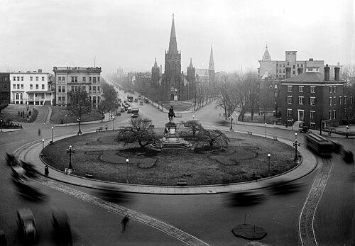 ワシントン DC のトーマス サークル、1922 年
 -


1960年代の近代的なラウンドアバウトの発展
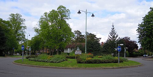
現代のラウンドアバウトの普及は、1960年代に英国の交通研究所のエンジニアが円形交差点を再設計し、標準化したときに始まりました。フランク・ブラックモアは「優先ルール」の開発を主導し、その後、容量と安全性の制限を克服するためにミニラウンドアバウト[16] [17]を発明しました。優先ルールにより、交通の流れが最大10%改善されました。[18] 1966年、英国はすべての円形交差点で、進入車両が循環車両に道を譲ることを義務付けるルールを採用しました。交通研究委員会のガイドによると、現代のラウンドアバウトは、古いロータリーやトラフィックサークルと比較して、運用と安全性の両方の点で大幅に改善されています。[14]この設計は、1966年11月に英国ですべての新しいラウンドアバウトに義務付けられました。 [19]オーストラリアと他の英国の影響を受けた国は、英国以外で最初に現代のラウンドアバウトを建設しました。[3]
1970年代からヨーロッパと北米で拡大
- 1951年、当時イギリスの植民地であったキプロスは、主要都市にラウンドアバウトを導入しました。
- 1970年代にはフランスとノルウェーが近代的なラウンドアバウトを採用した。[20]
- 1973年、米国のシアトル市は交通を緩和するために既存の交差点内に小さな環状交差点を設置し始めました。[21] 2021年現在[update]、シアトル市は住宅街を中心に1,200以上の環状交差点を設置しています。[22]
- 1980年、スイスには19のラウンドアバウトがあった。[3]
- 1980年、ノルウェーには15のラウンドアバウトがあった。[3]
- 1980年代初頭には、オランダでも片側1車線のラウンドアバウト(またはミニラウンドアバウト)が導入された。[20]ランドスタッドの交通密度にラウンドアバウトでは対応できないのではないかという懸念から、比較的人口の少ないオランダ北部と東部で導入が始まった。しかし、片側1車線のラウンドアバウトが信号付き交差点よりもさらに高い容量を持つことが判明すると、オランダ西部でも大量に建設された。[20]
- 1983年、フランスは国道に進入時譲歩ルールを導入し、それ以来国内のラウンドアバウトは急増した。[3]
- 1985年、ノルウェーはすべてのラウンドアバウトの入口に譲歩標識を設置しました。その後、安全性と交通の流れが急速に改善し、[3]ノルウェーのラウンドアバウトの数は1980年の15から1990年には350、1992年には500に増加しました。[3]
- 1987年、スイスでは進入時譲歩ルールが導入され、それ以来、ラウンドアバウトの数は1980年の19から1992年初頭には220に増加し、さらに500の建設が検討されました。[3]
- 1980年代後半、オランダではわずか6年間で約400のラウンドアバウトが建設され、大きな成長が見られました。[3] 1990年代には建設が加速し、2001年までにオランダには推定1,500~1,800のラウンドアバウトがあり、その半分以上が市街地内にありました。[20]
- 1990 年に米国で最初の近代的なラウンドアバウトが建設されましたが、北東部の一部では古いラウンドアバウト (ロータリーまたはトラフィック サークルと呼ばれる) がやや一般的でした。
- 1991年、フランスでは毎年1,000個のラウンドアバウトが建設されていました。[3]
- 1980年代に近代的なラウンドアバウトの人気が高まるにつれ、古い環状交差点は人気を失い、その多くが近代的なラウンドアバウトや他のタイプの交差点に改造されました。[3]
- 1999年、カナダは初の近代的なラウンドアバウトを建設した。[23]
- 21 世紀初頭には、ヨーロッパではラウンドアバウトが広く普及していました。たとえば、
- 2010年にはフランスには3万以上のラウンドアバウトがあった。[24]
- 2015年には英国で約25,000件あった。[25]
-
 ラウンドアバウト、ハールレム、オランダ、1990 年。自転車もラウンドアバウトを利用することがあります。
 -
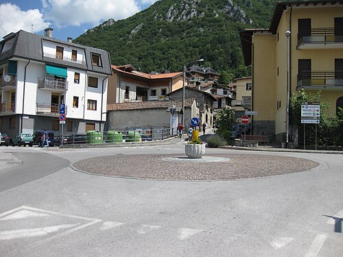 イタリア、バルツィオの小さなロータリー
 -
 オーストリア、シュトラスヴァルヒェンのラウンドアバウト
 -
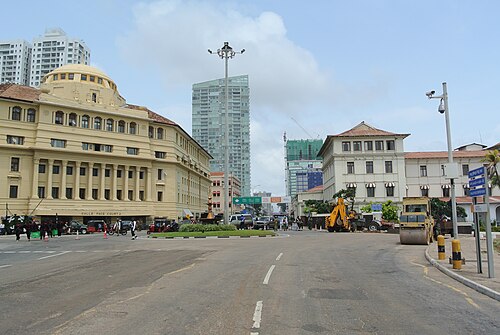 スリランカのコロンボ中心部のラウンドアバウト
 -
 ボスニア・ヘルツェゴビナのゼニツァにある2車線のレインドロップファウンテンラウンドアバウト。2011年以降、すべての信号機がラウンドアバウトに置き換えられました。
 -
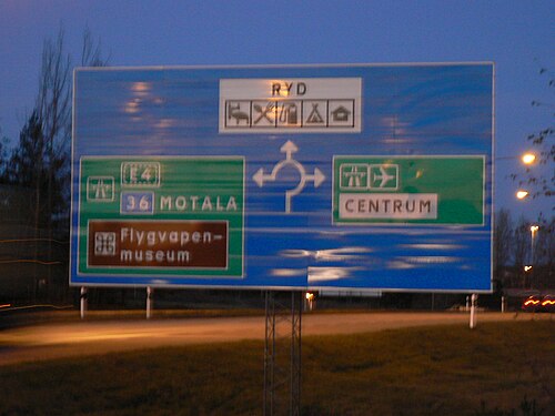 スウェーデン、リンシェーピングのラウンドアバウト標識
 -
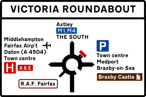 英国で使用されているラウンドアバウトの標識の例
1990年代以降に北米で導入
アメリカでは、フランク・ブラックモアとリーフ・オーストンによる長年の計画と啓発運動の末、1990年代に近代的なラウンドアバウトが登場した。彼らは、当時すでに他国で確立されていた安全性と交通の流れの向上をアメリカにもたらそうとした。[15]最初のラウンドアバウトは 1990年にネバダ州サマーリンに建設され、翌年にはもう1つが建設された。[3] [26]このラウンドアバウトは住民の失望を招き、地元のニュース番組は「警察ですら、[ラウンドアバウトは]時々混乱を招くことがあることに同意している」と報じた。[27] 1990年から1995年にかけて、カリフォルニア、コロラド、フロリダ、メリーランド、ネバダ、バーモントで数多くの近代的なラウンドアバウトが建設された。[3]

1960 年代のイギリスと同様に、自治体が新しいラウンドアバウトを導入すると、ある程度の住民の抵抗に遭遇することが多かった。
- アメリカ人がラウンドアバウトの進入方法、特に退出方法について混乱していることは、映画「ヨーロピアン・バケーション」(1985年)で描かれているように、嘲笑の対象となった。[24] [28] [15] : 6:45
- 1998年に自治体を対象に行われた調査では、建設前には世論の68%が反対していたが、建設後は賛成が73%に変わった。[29]
- 2007年の調査では、建設前の国民の支持率は22%から44%で、建設後数年で57%から87%に上昇した。[30]
- しかし、2011年までに約3,000のラウンドアバウトが設置され、その数は着実に増加しました。[24] [28] [15] : 6:45
2010年代半ばには、当時アメリカにあった約4,000の近代的なラウンドアバウトのうち約3%が、ジェームズ・ブレイナード市長が積極的に建設を推進していたインディアナ州カーメルに集中しており、安全性の向上により、1996年以降、市内での自動車事故による負傷者が80%減少した。[15] : 0:02 2015年12月現在、アメリカには約4,800の近代的なラウンドアバウトがあった。[要出典]例えば、ワシントン州には2016年10月時点で約120のラウンドアバウトがあり、すべて1997年以降に建設されたもので、さらに増設が計画されている。[31][update][update]
カナダで最初のラウンドアバウトはエドモントンにあった。1954年までに7か所あった。しかし、1990年代までカナダ全土で普及することはなかった。その後15年間で、ヨーロッパでの成功により、交通計画者や土木技術者の間で人気が高まった。2014年までに、当時カナダには約400か所のラウンドアバウトがあり(ケベック州、アルバータ州、ブリティッシュコロンビア州、オンタリオ州がほとんど)、住民9万人に1か所の割合だった(その年の米国では住民8万4千人に1か所だった)。[23]
現代のラウンドアバウト
ラウンドアバウトの標識の例
右側通行の場合に表示されます。左側通行の場合は矢印が反転します。
「現代のラウンドアバウト」は、道路交通が中央島の周りを一方向に流れ、循環する流れが優先されるタイプのループ交差点です。標識は通常、環状交差点に入る交通に速度を落とし、すでに環状交差点にいる交通に道を譲るよう指示します。[32] [33]
ラウンドアバウトに進入する交通は低速であることが求められるため、安全性を高めるために交差点に進入する交通を減速させるように物理的に設計されており、道路は通常、交差点に放射状に接近します。一方、旧式の環状交差点は速度を上げるように設計されており、道路が環状交差点に接線方向に進入するようになっています。
ラウンドアバウトは、通常、速度要件が低いため、アクセス制限のある高速道路では使用されませんが、アクセス制限道路などの低グレードの高速道路では使用されることがあります。そのような道路がラウンドアバウトを組み込むように再設計される場合、進入路を曲げるなどの工夫により、交通速度を低下させる必要があります。
多くの環状交差点が近代的なラウンドアバウトに改造されており、ニューヨークの旧キングストン環状交差点やニュージャージー州のいくつかの環状交差点もその一つである。 [34] [35]その他にも、マサチューセッツ州チェルムズフォードのドラムヒルロータリーのように信号付き交差点に改造されたものもあり、現在は6車線で4つの独立した交差点で制御されている。[36]
日本でラウンドアバウトは、重大事故や交通渋滞を防ぐ目的で2014年9月に初めて導入されました。[37]
用語
ラウンドアバウトという言葉は、20世紀初頭のイギリスで使われ始めた。[1]ラウンドアバウトは、他の英語圏の国ではカルーセル、またはメリーゴーラウンドとして知られる遊園地の乗り物に付けられた伝統的な英語名でもある。
米国の辞書では、ラウンドアバウト、トラフィックサークル、ロードサークル、ロータリーという用語は同義語です。[38]しかし、リーフ・オーストンなどの専門家は、現代のラウンドアバウトと非準拠のトラフィックサークルの特徴を区別する必要性を強調しています。[3]
- 現代のラウンドアバウト
- 進入する交通は循環する交通に道を譲る
- 進入する交通は中央島の中心を目指し、ゆっくりとその周りを迂回する。
- 上流の道路は入口でフレア状に広がり、車線が追加されることが多い
- 非適合環状交差点
- 進入する交通は循環する交通を遮断する
- 進入する車は中央島の片側(右側通行の場合は右側)を狙い、高速で直進する。
- 入口でレーンが追加されない
米国運輸省は、進入するドライバーが他のドライバーに道を譲ることを必要とするラウンドアバウトを区別するために、現代のラウンドアバウトという用語を採用しました。米国北東部には多くの古い環状交差点が残っています。[2]現代のラウンドアバウトの中には、追加の道路を囲むように長くなっているものもありますが、交通は常にループ状に流れています。
ロータリー
アメリカ合衆国では、交通技術者は、高速道路やアクセス制限のある高速道路の間の大規模な円形のジャンクションを指すのにロータリーという用語を使用するのが一般的です。このタイプのロータリーは、通常、環状交差点の内側と進入路で高速走行を特徴としています。[39]
しかし、米国のニューイングランド地方では、現代的なデザインのものも含め、すべてのラウンドアバウトを指す一般的な用語として「ロータリー」が一般的に使用されています。これらの州の州法では、ロータリーをすでに走行している車両が常に優先権を持つことが義務付けられています。たとえば、マサチューセッツ州では、「ロータリー交差点に進入する車両の運転者は、交差点にすでにいる車両に優先権を譲らなければならない」と規定されています。 [40]ロードアイランド州では、進入車両は「ラウンドアバウト内の車両に道を譲る」と規定されています。[41]
その他の用語
スコットランドの都市ダンディーで使われる方言では、circleはラウンドアバウトを指すのに使われる。[42]
イギリスのウェスト・ミッドランズでは、islandが一般的に使用されている。[43]
チャンネル諸島には、「フィルター・イン・ターン」と呼ばれる3番目のタイプのラウンドアバウトが存在する。ここでは、接近するドライバーは通常のようにラウンドアバウトの交通に道を譲ることも優先権を持つこともなく、交代で各ラウンドアバウトから進入する。ジャージー島のラウンドアバウトのほとんどすべてがこのタイプである。[44]
フィリピンでは、ラウンドアバウトを指すときに 「ロタンダ」または「ロトンダ」という用語が使用されます。
操作と設計


現代のラウンドアバウトの基本原則は、信号機を必要とせずに、進入するドライバーがラウンドアバウト内の交通に道を譲ることである。対照的に、古いラウンドアバウトでは通常、周回するドライバーが進入する交通に道を譲る必要がある。ラウンドアバウトには内側の車線があることもある。[45]一般的に、交差道路の車線数がラウンドアバウトと同じであれば、複数車線のラウンドアバウトの内側の車線から直接退出することが許可されている。対照的に、古いラウンドアバウトの内側の車線からの退出は通常許可されておらず、交通はまず外側の車線に移動しなければならない。
車両は中央島の周りを時速 25~40 km (15~25 mph) の速度で一方向に循環します。左側通行の国では時計回り(上から見て) に循環し、右側通行の国では反時計回りに循環します。
複数車線のラウンドアバウトの直径は通常75メートル(250フィート)未満です。[46]古い環状交差点やラウンドアバウトのインターチェンジはかなり大きい場合があります。ラウンドアバウトは、同じ容量の信号付き交差点とほぼ同じ大きさです。
設計基準は次のとおりです。
- 通行権:進入車両と旋回車両にどちらが通行権を持つか。ニュージャージー州運転者マニュアルでは、交通流制御標識がない場合、「旋回部の歴史的に確立された交通流パターン」に基づいて交通が道を譲ることを推奨しており、[47]定められたルールはない。ニューイングランド、[48] ワシントンDC、ニューヨーク州では、[49]進入車両が道を譲っており、これは米国以外のほぼすべての国で標準となっている。
- 進入角度:角度は、全速力で進入できる斜め(接線方向)から90度(垂直方向)までの範囲です。[50]車両が過速で進入するのを避けるためには偏向が必要です。[51]
- 交通速度:進入速度が速い(時速30マイルまたは48km/h以上)と、循環する車両は道を譲る必要があり、頻繁に停止するため、現代のラウンドアバウトに比べて容量が低下し、衝突率が高くなります。[52]
- 車線変更: 許可されているか
- 直径:交通量が多いほど円が大きくなります。[50]
- 島の機能:駐車場、公園、噴水など[50]
島々
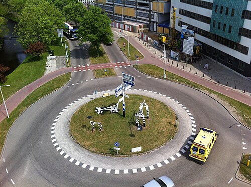
現代のラウンドアバウトには中央の島があり、装飾のため各入口または出口に歩行者用島が設けられることもあります。
デンマークでは、特定の高さのある島、またはそれが不可能な場合は、より大きな例では生垣や木の輪などの障害物の採用が広まり始めています。これは、ラウンドアバウトの安全上の利点をさらに高めるために行われます。障害物は、従来の交差点と比較して、ラウンドアバウト自体よりもドライバーに不快感を与えることがわかっているため、ドライバーのさらなる観察と注意を促すためです。デンマークでは、ラウンドアバウトでの高さとタイプに応じて、事故が27%から84%減少することがわかりました。研究では、0〜0.9メートル、1〜1.9メートル、2メートル以上の高さが評価されました。すべての高さで、特に人的傷害につながる事故が最も減少し、前述の高さで-47%から-84%減少することがわかりました。[53]ドライバーのイライラのレベルを過小評価してはいけません。それは、ドライバーに進行方向の側面に注意を払わせることが設計の重要なポイントだからです。このため、ドライバーはこうした設計に不満を抱くことになる。デンマークは、望ましい運転行動が快適さにつながるように道路インフラを設計すること、つまり、車線幅が制限速度に相当し、学校などの安全上の懸念がある地点の近くでは障害物が減速を促すように設計することを重視しているためである。ドライバーにとっての論争は、安全性が証明され、広く採用されてから10年経った今でも、ベテランの運転教官がこの不快感について不満を言うほどである。[54]
中央

中央の島は、ドライバーが横断できない程度の高さで、幅の広い車両や長い車両がラウンドアバウトを通行できる程度に低いトラック用エプロンで囲まれている場合があります。島は視覚的な障壁となり、近づいてくるドライバーにラウンドアバウトの存在を知らせ、ドライバーがラウンドアバウトの進路上の交通に注意を向けるよう促します。視覚的な障壁は事故率を大幅に低減します。[55]そうしないと、ラウンドアバウト内またはその付近のどこに車両があっても、進入してくる車両が反対側からであっても停止して通過を待つことになり、不必要に交通の流れが減少する可能性があります。障壁は、造園された丘、盛り上がった壁、木、または背の高い低木にすることができます。造園された丘の頂上には道路標識や旗竿を立てることもできます。
一部のコミュニティでは、島を記念碑、大きな公共芸術の展示、または噴水のために使用しています。歩行者は環状の車線を横断することが禁止されている場合があります。中央の島へは、安全のため地下道または高架道路を通って行く必要があります。
アートインスタレーション
_-_050.jpg/500px-Guadalajara,_Jalisco,_Mexico_(2021)_-_050.jpg)
ラウンドアバウトは世界中でアートインスタレーションを魅了してきました。
- ベンド、オレゴン州(アメリカ合衆国);ベンドのラウンドアバウトの彫刻は、アメリカ芸術協会によって、国内で最も革新的なパブリックアートの37の1つとして表彰されました。[56] [57]
- フエルテベントゥラ島、カナリア諸島(スペイン); 地方自治体はいくつかのラウンドアバウトに彫刻を展示した。[58]
- ヨーロッパの多くの国(フランス[59]を筆頭に、ドイツ[60]、オーストリア[60] 、イタリア[61]、スペイン[62] 、その他[60])では、ラウンドアバウトをアートインスタレーションとして広く利用しています。[63] [64]
- マルク・レスキュイエが作成したフランスのラウンドアバウトの目録には、2010年初頭に芸術的な装飾が施されたラウンドアバウトが3,328個記載されていた。[63] [65]
- メキシコのグアダラハラにあるミネルバラウンドアバウトは、この街で最も有名な記念碑の 1 つです。大きな噴水に囲まれた台座の上に立つミネルバ女神が描かれており、「正義、知恵、そして強さがこの忠実な街を守ります」という碑文が刻まれています。
- スペインのマドリードにあるアルカラ門やフランスのパリにある凱旋門など、ヨーロッパのいくつかの有名な建造物は、ラウンドアバウトによって道路交通から隔離されています。
- カリフォルニア州ベーカーズフィールドのガルセス記念サークルにはフランシスコ・ガルセス神父の像が建てられている。
- フィリピンのサンボアンガ・シブガイのイピルの町には、芸術とバイバイイン文字を含むオベリスクがあります。
歩行者
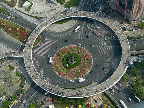
より大きなラウンドアバウトでは、各入口/出口に歩行者島を設け、ドライバーが減速してラウンドアバウトに入る準備をするように促します。また、歩行者が横断中に一時停止できる避難場所も提供します。ラウンドアバウトに出入りする車両や自転車は、歩行者を含むすべての交通に道を譲らなければなりません。[66]
横断歩道
Pedestrian crossings at each entry/exit may be located at least one full car length outside the circle. The extra space allows pedestrians to cross behind vehicles waiting to enter the circle, and to allow exiting vehicles to stop for pedestrians without obstruction. Each pedestrian crossing may traverse a pedestrian island for protection that also forces drivers to slow and begin to change direction, encouraging slower, safer speeds. On the island, the pedestrian crossing may become diagonal, to direct the gaze of those crossing into exiting traffic.
Bicycles
Physically separated bikeways best protect cyclists.[67][68][69] Less optimally, terminating cycle lanes well before roundabout entrances requires cyclists to merge into the stream of motor traffic, but keeps cyclists in full view of drivers, at some cost in motor vehicle speed. Cyclists may also be permitted to use pedestrian crossings.
Traditional cycle lanes increase vehicle–bicycle collisions. When exiting, a motorist must look ahead to avoid colliding with another vehicle or with pedestrians on a pedestrian crossing. As the intersection curves away from the exit, the path of an exiting vehicle is relatively straight, and so the motorist may often not slow substantially. To give way to a cyclist on the outside requires the exiting motorist to look toward the rear, to the perimeter. Other vehicles can obstruct the driver's view in this direction, complicating the motorist's task. The more frequent requirements for motorists to slow or stop reduce traffic flow. A 1992 study[70] found that the risk to cyclists is high in all such intersections, but much higher when the junction has a marked bicycle lane or sidepath around its perimeter.[71][72] Cycle lanes were installed at Museum Road, Portsmouth, but were replaced by a narrowed carriageway to encourage lane sharing.
The roundabout at the Brown Road and Loop 202 interchange in Mesa, Arizona, adopts a U.S.-recommended design.[73] On-street pavement markings direct cyclists to enter the sidewalk at the end of the bike lane. Cyclists who choose to travel on the wide sidewalk, cross roundabout arms perpendicularly, well outside the circle. A pedestrian island allows pedestrians and cyclists to cross one lane at a time.
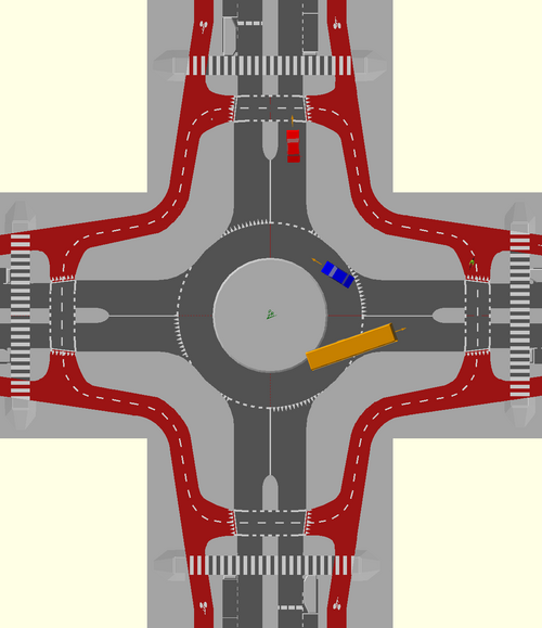
Protected roundabouts (or Dutch roundabout) were developed in the Netherlands, with cyclists separated from vehicles using dedicated lanes.[74] As cyclists will conflict with motorists at the exit arms of the motorised roundabout, priority must be established. In the Netherlands, cyclists will normally be given priority to promote cycling over driving.[74] As well as their use in the Netherlands and Denmark, these designs have been subsequently built in the United Kingdom and Ireland.[75][76]
-
 The Hovenring bicycle roundabout in the Netherlands is an innovative design, completely separating bicycles from vehicular traffic.
 -
 Pavement markings invite cyclists to enter sidewalk on approach to roundabout in Mesa, Arizona. Cyclists are still permitted to use the roundabout like any other vehicle.
 -
 Cyclists can choose to ride on the sidewalk on far right, or in the main lanes of this roundabout in Mesa, Arizona.
 -
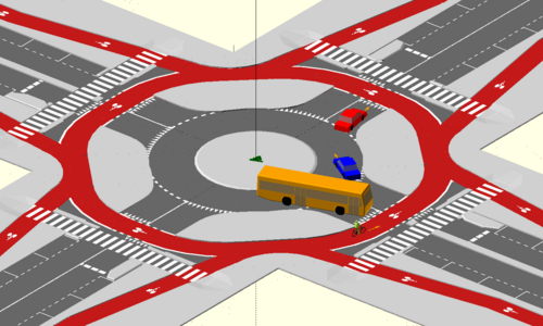 3D view of a protected roundabout, as commonly used in the Netherlands
Capacity and delays

The capacity of a roundabout varies based on entry angle, lane width, and the number of entry and circulating lanes. As with other types of junctions, operational performance depends heavily on the flow volumes from various approaches. A single-lane roundabout can handle approximately 20,000–26,000 vehicles per day, while a two-lane design supports 40,000 to 50,000.[68]
Under many traffic conditions, a roundabout operates with less delay than signalised or all-way stop approaches. Roundabouts do not stop all entering vehicles, reducing both individual and queuing delays. Throughput further improves because drivers proceed when traffic is clear without waiting for a signal to change.
Roundabouts can increase delays in locations where traffic would otherwise often not be required to stop. For example, at the junction of a high-volume and a low-volume road, traffic on the busier road would stop only when cross traffic was present, otherwise not having to slow for the roundabout. When the volumes on the roadways are relatively equal, a roundabout can reduce delays, because half of the time a full stop would be required. Dedicated left turn signals (in countries where traffic drives on the right) further reduce throughput.
Roundabouts can reduce delays for pedestrians compared to traffic signals, because pedestrians are able to cross during any safe gap rather than waiting for a signal. During peak flows when large gaps are infrequent, the slower speed of traffic entering and exiting can still allow crossing, despite the smaller gaps.
Studies of roundabouts that replaced stop signs and/or traffic signals found that vehicle delays were reduced 13–89 percent and the proportion of vehicles that stopped was reduced 14–56 percent. Delays on major approaches increased as vehicles slowed to enter the roundabouts.[6]
Roundabouts have been found to reduce carbon monoxide emissions by 15–45 percent, nitrous oxide emissions by 21–44 percent, carbon dioxide emissions by 23–37 percent and hydrocarbon emissions by 0–42 percent. Fuel consumption was reduced by an estimated 23–34 percent.[6]
Capacity modelling
Many countries have researched roundabout capacity. The software can help calculate capacity, delay and queues. Packages include ARCADY, Rodel, Highway Capacity Software and Sidra Intersection. ARCADY and Rodel are based on the Transport Research Laboratory mathematical model. The TRL approach is derived from empirical models based on geometric parameters and observed driver behaviour with regard to lane choice. Sidra Intersection software includes roundabout capacity models developed in Australia and the US.
Research on Australian roundabouts was conducted in the 1980s at the Australian Road Research Board (ARRB).[77] Its analytical capacity and performance models differ from the TRL model significantly, following a lane-based gap-acceptance theory including geometric parameters.
Research on U.S. roundabouts sponsored by the Transportation Research Board (TRB) and Federal Highway Administration (FHWA) culminated in a capacity model that was included in the Highway Capacity Manual (HCM) Edition 6[78] and the TRB-FHWA Roundabout Informational Guide (NCHRP Report 672).[79] The HCM Edition 6 model is based on lane-based gap-acceptance theory. A recent NCHRP survey of US state transport agencies found that Sidra Intersection is the most widely used software tool in the US for roundabout analysis.[80]
Safety
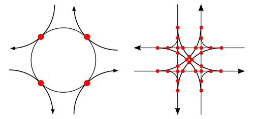

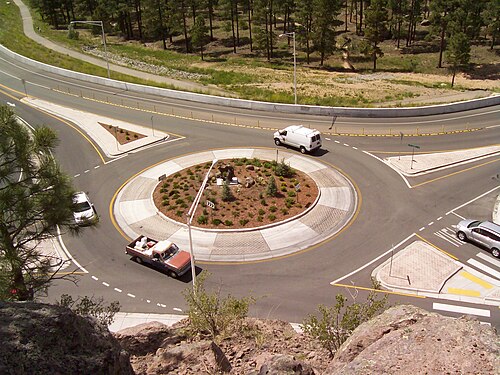

Statistically, modern roundabouts are safer for drivers and pedestrians than both older-style traffic circles and traditional intersections.[81] Compared with these other forms of intersections, modern roundabouts experience 39% fewer vehicle collisions, 76% fewer injuries and 90% fewer serious injuries and fatalities (according to a study of a sampling of roundabouts in the United States, when compared with the junctions they replaced).[82] At junctions with stop signs or traffic lights, the most serious accidents are right-angle, left-turn or head-on collisions where vehicles move fast and collide at high impact angles, e.g. head-on. Roundabouts virtually eliminate those types of crashes. Instead, most crashes are glancing blows at low angles of impact.[83][84] Further, a study based on satellite imagery of all intersections in Australia observed consistently low speeds on roundabouts compared to other intersection types, contributing to reduced injury severity in case of a crash.[85]
Some larger roundabouts take foot and bicycle traffic through underpasses or alternate routes. However, an analysis[86] of the New Zealand national crash database[87] for the period 1996–2000 shows that 26% of cyclists reported injury crashes happened at roundabouts, compared to 6% at traffic signals and 13% at priority controlled junctions. The New Zealand researchers propose that low vehicle speeds, circulatory lane markings and mountable centre aprons for trucks can reduce the problem.[88] The most common roundabout crash type for cyclists, according to the New Zealand study, involves a motor vehicle entering the roundabout and colliding with a cyclist who already is travelling around the roundabout (more than half of cyclist/roundabout crashes in New Zealand fall into this category). The next most common crash type involves motorists leaving the roundabout colliding with cyclists who are continuing farther around the perimeter.
Vision-impaired pedestrians
Poorly designed walkways increase risks for the vision-impaired, because it is more difficult than at a signalised intersection to audibly detect whether there is a sufficient gap in traffic to cross safely. At a signalised intersection, traffic comes to a stop, and an audible sound can be generated to indicate that it is time to cross.[89]
This issue has led to a conflict in the United States between the vision-impaired and civil engineering communities. One solution is to provide manually-operated pedestrian crossing signals at each entry. This increases construction and operation costs, and requires some way to disrupt traffic long enough for the pedestrian to cross (such as a HAWK beacon) that defeats the purpose of the roundabout. Signalisation also increases delays for most pedestrians during periods of light traffic, since pedestrians need to wait for a signal to change before (legally) crossing.[90]
Signalised pedestrian crossings are normally used on large-diameter roundabout interchanges rather than small-diameter modern roundabouts.
Types of circular intersections

Large roundabouts, such as those used at motorway junctions, typically have two to six lanes and may include traffic lights to regulate flow.
Some roundabouts have a divider or subsidiary deflection island, by means of which is provided a "free flow" segregated left- (or right-) turn lane (for the UK see Design Manual for Roads and Bridges TD 51/03) between traffic moving between two adjacent roads, and traffic within the roundabout, enabling drivers to bypass the roundabout.
Gyratory system
The term "gyratory" (for example, Hanger Lane gyratory) is sometimes used in the United Kingdom for a large circular intersection with non-standard lane markings or priority arrangements, or where there are significant lengths of carriageway between the entry arms, or when buildings occupy the central island.[92]
In the 21st century several gyratory systems in London have been removed, including Tottenham Hale[93] and Elephant and Castle.
Smaller, small and mini-roundabouts

As the overall or external size of a roundabout (in the UK referred to as the Inscribed Circle Diameter – ICD) is reduced, so the maximum practicable (and prescribed) diameter for the central island is also reduced, whilst the width of the circulatory carriageway increases (due to the greater width of vehicle swept path at smaller turning radii). In most cases, this results in it being too easy – certainly when traffic is light relative to capacity – for drivers to traverse the roundabout at relatively high speed, with scant regard for road markings or the potential dangers to self or conflicts with other road users. To mitigate this risk, a proportion of the circulatory carriageway – an annulus around the central island – is segregated from general use by demarcation lines and differentiated from the outer annulus of the carriageway by a combination of a slightly raised surface, adverse crossfall, contrasting colours and textures and demarcating lines. The effect of this is to discourage drivers from taking a more direct path through the roundabout, their line of least resistance is more tightly curved (and therefore slower) but more bearable. The inner annulus provides for the trailing axles of longer or articulated vehicles to sweep across the inner annulus, which is therefore known as an over-run area (in UK usage), truck apron, or mountable apron.
The smaller the roundabout, the more such mitigation measures are likely to be abused – the less effective they will be. In the UK the minimum size for roundabouts with raised islands is 28 metre diameter ICD with a 4-metre diameter island. This threshold being driven primarily by vehicle geometry – which is globally relatively consistent – rather than driver behaviour, it is adopted in other jurisdictions too. Below this minimum size, the mini-roundabout prevails.
Mini-roundabouts
After developing the offside priority rule, Frank Blackmore, of the UK's Transport Research Laboratory, turned his attention to the possibility of a roundabout that could be built at sites lacking room for a conventional roundabout.[94]


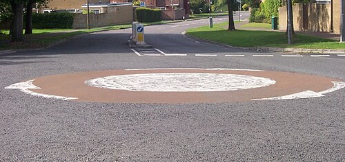

Mini-roundabouts can incorporate a painted circle or a low dome but must be fully traversable by vehicles. Motorists can drive over them when there is no other traffic, but it is dangerous to do so otherwise. Once the practice is established it may be difficult to discourage. Mini-roundabouts use the same right-of-way rules as standard roundabouts but produce different driver behaviour. Mini-roundabouts are sometimes grouped in pairs (a double mini-roundabout) or in "chains", simplifying navigation of otherwise awkward junctions. In some countries road signs distinguish mini-roundabouts from larger ones.
Mini-roundabouts are common in the UK, Ireland and Hong Kong (particularly on Hong Kong Island), as well as Irapuato in Mexico.
In the UK and also in other jurisdictions that have adopted mini-roundabouts, to drive across the central disc or dome when it is practicable to avoid it is an offence. Vehicles are required to treat the painted circle as if it were a solid island and drive around it.[95] Some local authorities paint double white lines around the circle to indicate this, but these require permission from the Secretary of State for Transport. The central dome also must be able to be overrun by larger vehicles.
In the UK – and also in other highway jurisdictions – the maximum size for a mini roundabout is 28 metre (30 yard) ICD (inscribed circle diameter).
Raindrop roundabouts
These roundabouts do not form a complete circle and have a "raindrop" or "teardrop" shape. They have also been used at bowtie intersections, replacing traffic signals that are inefficient without a turning lane. In addition to their use at intersections, raindrop roundabouts are also used in dogbone interchanges (described below).
Balcony roundabout
A balcony roundabout is just an elevated roundabout. They are constructed in such a way that vulnerable road users can cross underneath the roundabout. Footpaths and cycle paths along the different roads connect to the square under the roundabout. Vulnerable road users do not interfere with motorised traffic on the roundabout, reducing the risk of collision.
Turbo roundabouts

In the Netherlands, Belgium, Bosnia and Herzegovina, the United Kingdom, Finland, Spain, Poland, Hungary, Slovenia, Slovakia, the Czech Republic, North Macedonia, Croatia, Germany, and the U.S. states of California and Florida, a relatively new type of two-lane roundabout designs is emerging, called "turbo roundabouts". These designs require motorists to choose their direction before entering the roundabout, thereby eliminating many conflicting paths and choices on the roundabout itself so that traffic safety is increased, as well as speed and capacity. These designs, seen from above, typically result in a spiralling flow of traffic. One minor drawback is that turbo roundabouts are often marked out such that a U-turn by means of the roundabout is not possible for drivers approaching on certain arms.
Several variations of turbo roundabouts exist. They are frequently designed for the intersection of a major road crossing a road with less traffic.
An early application of the principle was a six-arm and therefore relatively large (and fast) non-circular roundabout at Stairfoot, Barnsley, South Yorkshire, which was given spiral marking about 1984. At that time the method was considered experimental and needed special consent from central authorities. The turbo roundabout was formally developed in 1996 in the Netherlands by Lambertus Fortuijn, a researcher from the Delft University of Technology.[96] Similar roundabouts, with spiralling lane markings, have been used for many years in the UK e.g. the A176/A127 (eastbound) at Basildon, Essex (51°33′41″N 0°27′11″E / 51.561399°N 0.452934°E / 51.561399; 0.452934). However, it was not until 1997 that the UK's national highway authorities published guidance (DMRB TA-78/97) that in effect endorsed the use of spiral markings in certain circumstances.
Turbo roundabouts can be built with raised lane separators (common in the Netherlands[97]) or with lane markings only. The use of raised lane separators prevents road users from weaving (thereby reducing conflicts) but can make manoeuvring more difficult for large vehicles.

According to simulations, a two-lane roundabout with three exits should offer 12–20% greater traffic flow than a conventional, three-lane roundabout of the same size. The reason is reduced weaving that makes entering and exiting more predictable. Because there are only ten points of conflict (compared with 8 for a conventional single lane roundabout, or between 32 and 64 with traffic signal control), this design is often safer as well. Research and experiments show that traffic accidents are reduced by 72% on turbo roundabouts compared to multi-lane roundabouts, which have 12 points of conflict.[98] Research at Windesheim University also shows that turbo roundabouts reduce accidents including casualties by some 75% when compared to regular intersections, and by 61% compared to single-lane roundabouts.[99] The same research made it very clear that it is safer for cyclists not to have priority over motor vehicles on the roundabout, than to have it.[99] At least 70 have been built in the Netherlands, while many turbos (or similar, lane splitting designs) can be found in southeast Asia.[100] Multi-lane roundabouts in the United States of America are typically required to be striped with spiral markings,[101] as most states follow the federal Manual on Uniform Traffic Control Devices.
Sub-sea roundabouts
A new development is the roundabout below the seabed, in locations where multiple undersea traffic tunnels join. The first such roundabout is in the Eysturoy Tunnel (Eysturoyartunnilin), opened in December 2020 in the Faroe Islands. It connects the main island Streymoy with two locations on the island Eysturoy that are separated by a long fjord, Skálafjørður. So, three roads meet at this roundabout. Total length of the system is 11.24 km (6.98 mi). It was the largest ever infrastructure project in the Faroe Islands, estimated to have cost around a billion Danish kroner.[102]
Motorways

Roundabouts are generally not appropriate for placement on motorway or freeway mainlines because the purpose of such facilities is to provide for uninterrupted traffic flow. However, roundabouts are often used for the junction between the slip roads (called ramps in North America) and the intersecting road. A single roundabout, grade separated from the mainlines, may be used to create a roundabout interchange. This type of junction is common in the UK and Ireland.
Alternatively, separate roundabouts also may be used at the slip road intersections of a diamond interchange to create what often is referred to as a "dumbbell interchange", which is increasingly common in both Europe and North America due to its reduced need for wide or multiple bridges. A variation of the dumbbell interchange, often called a "dogbone interchange", occurs when the roundabouts do not form a complete circle but are instead raindrop roundabouts (described above). This configuration reduces conflicts between vehicles entering the raindrop roundabouts from the ramps, reducing queueing and delays, compared with the dumbbell interchange.
Additional use of roundabouts for high-speed junctions is the 3-level stacked roundabout—this is a roundabout interchange where both of the roadway mainlines are grade separated. In the United Kingdom, the M25/A3, M8/M73 and A1(M)/M18 interchanges are examples of this type. These junctions, however, have less capacity than a full free-flow interchange. A similar design to this is the three-level diamond interchange.
Most junctions on Dublin's M50 motorway C-road were built using a standard roundabout interchange. The traffic volume of several of these junctions increased to a level higher than the capacity such roundabouts can accommodate, and in turn, have been converted into partially or fully free-flowing interchanges. One example is the Red Cow interchange. In Northern Ireland, the junction between the M1 and M12 (Craigavon connector motorway) is via a standard roundabout with a raised centre, three onslips and three offslips, and two lanes.
In the city of Malmö, Sweden, a roundabout connects two motorways, E22 from Lund, and the Inner ring road.
In the Netherlands, A6 motorway and A7 motorway used to cross near Joure using a roundabout until October 2017, when the junction was turned into a full Y-interchange.[103] The junction between the A200 and the A9 uses a 3-level stacked roundabout. Near Eindhoven (the Leenderheide junction), the junction for the A2 uses a roundabout. An overpass was built for the A67 from Antwerp to Germany.
Near Liège, Belgium, the Cheratte interchange between the A3/E40 and A25/E25 functions partially as a roundabout, with through traffic allowed to continue without entering the junction and traffic changing between motorways required to use the roundabout.
Rotary interchanges operate with traffic circles rather than roundabouts. Rotary interchanges are common in New England, particularly in the state of Massachusetts, but a European example of a rotary interchange may be found in Hinwil, Switzerland.
Signalised roundabouts

A signalised roundabout is one where one or more entry is controlled by traffic signals, rather than by assumed priority. For each signalised entry there will also be a signalised stopline immediately upstream on the circulatory section. The signals prevent blocking on the roundabout, and balance and improve traffic capacity.[104]
Examples include the M50 in Dublin; the Cherry Street roundabout in Kowloon, Hong Kong; Sheriffhall Roundabout in Edinburgh, Scotland; Newton Circus in Singapore; and many of the roundabouts along the Paseo de la Reforma in Mexico City.
An evolution of the signalised roundabout has been proposed recently.[105] It is based in avoiding stops by eliminating conflict points in roundabouts. This proposed new paradigm (SYROPS) forms platoons of vehicles (e.g. 2 x 3 cars) that arrive at the roundabout with speed identical to the average circulation speed in the roundabout and within the time interval (visualised as a rotating priority sector) assigned to his entrance, avoiding all the conflicts of passage and with it the stops and accelerations required in standard and in signalled roundabouts. Signalling signage is with lights for human drivers and optionally wireless for connected and autonomous vehicles.[undue weight? – discuss]
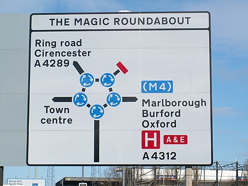
"Magic" roundabouts/ring junctions
"Magic roundabouts" direct traffic in both directions around the central island. They are officially known as "ring junctions". The first magic roundabout was constructed in 1972 in Swindon, Wiltshire, United Kingdom, designed by Frank Blackmore,[106] inventor of the mini-roundabout. The roundabout joins five roads and consists of a two-way road around the central island, with five mini-roundabouts meeting the incoming roads.[107]
The name derives from the popular children's television series, The Magic Roundabout, and is considered "magic" because traffic flows in both clockwise and anticlockwise directions. This is achieved by surrounding the main island with one smaller roundabout per entry/exit street. This pattern directs traffic in the usual clockwise (in LHT installations) or counter-clockwise (in RHT installations) manner around each mini-roundabout. Exiting the mini-roundabouts, traffic may proceed around the central island either in the usual direction (via the outer loop), or in the inverse direction (the inner loop). The arrangement offers multiple paths between feeder roads. Drivers typically choose the shorter, most fluid route. Although the safety record is good,[citation needed] many drivers find this system intimidating, and some drivers go to great lengths to avoid them.[108][109][110]
Similar systems are found in the Moor End roundabout in Hemel Hempstead (Hertfordshire), which has six intersections; in High Wycombe (Buckinghamshire),[111] the Denham Roundabout in Denham (Buckinghamshire), the Greenstead Roundabout in Colchester (Essex), "The Egg" in Tamworth (Staffordshire) and the Hatton Cross Roundabout in London.[112]
Churchbridge Junction in Staffordshire is a magic gyratory. This type of junction is similar to a magic roundabout, except that the constituent roundabouts are connected by longer lengths of roadway.[113]
-
-
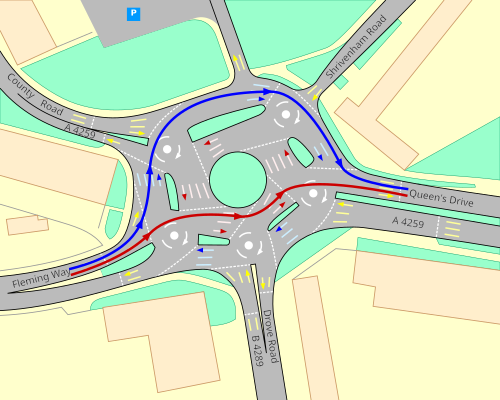 Map with traffic direction and two routes from Fleming Way to Queen's Drive
Dutch-style roundabouts for bicycles and pedestrians


Trams
Tram roundabouts, which are found in many countries, combine roundabouts for individual vehicles with tram lines. Large areas are needed for tram roundabouts that include a junction between tram lines. Tramways usually cross the centre of the roundabout. At busy junctions, this requires traffic lights or special signalling granting the trams priority. However, there are also roundabouts where trams and vehicles share the carriageway. Some roundabouts have a tram stop on the island.
- In France, tram roundabouts commonly have radii between 14 and 22 metres, although some have radii outside this range.[114]
- In some cities, the tramway bisects the roundabout. The French Cerema considers that the mix of priorities makes these confusing and difficult to understand: a traditional modern roundabout gives the priority to the central ring, while tram roundabouts give priority to the central ring but higher priority still to the tramway. This generates many collisions of cars and trams, between 7 and 10 for each tram roundabout in France between 2006 and 2015 (between 0.37 and 1.01 per year).[114][contradictory]
- In inner Melbourne, particularly in the inner suburban area of South Melbourne, where the tram network is extensive, tram tracks always pass through the central island, with drivers required to give way to vehicles approaching from their right and to trams approaching from right angles. The Haymarket roundabout between Royal Parade and Elizabeth Street contains a tram-stop, pedestrian crossings, three entering tram lines, traffic signals to stop vehicular traffic at each crossing point when a tram is due, service roads and a pedestrian crossing.
- Brussels tram roundabouts employ multiple configurations. At the Barrière de St-Gilles (Dutch: Bareel St-Gillis), tram tracks form a circle in the carriageway, while Churchill, Verboekhoven and Altitude Cent (Hoogte Honderd) have reserved tram tracks inside the roundabout. At Vanderkindere and Place Stéphanie (Stefaniaplein), they go straight through the centre, in the latter case with a slip track up the Chaussée de Charleroi (Charleroisesteenweg), while at Montgomery they tunnel underneath.
- In Dublin, Ireland, the Red Cow interchange at the N7/M50 junction is grade-separated and is signal-controlled with secondary lanes (separate from the main roundabout) for those making left turns. The junction, the busiest in Ireland, had tram lines added to it with the opening of the Luas system in 2004. The tracks pass across one carriageway of the N7, and across the southern M50 sliproads. Trams pass every five minutes at rush hour. The roundabout was replaced with a grade-separated free flowing junction.
- Gothenburg, Sweden has a tram roundabout at Mariaplan in the inner suburb of Majorna. The trams make a right turn, giving the roundabout an odd design.
- In Warsaw, trams typically cross straight through roundabouts and have junctions in the centre of them. In Wrocław, Poland, trams pass through the Powstańców Śląskich Roundabout, stopping in the roundabout (north-headed track).
- The Silesian tram network in Poland has two tram roundabouts. In the city centre of Katowice, the tram line passes through the centre of the Ziętka Roundabout in a north–south alignment, with a tram stop in the centre of the circle.[a] In Będzin, unusually, the tram junction itself forms a circular roundabout, with trams going around the circle; there are tram stops immediately outside the roundabout on each branch.
- In Vítězné náměstí (Victory Square) in Prague, Czech Republic, a tramway crosses the carriage way of the roundabout at three places. Entering as well as leaving trams give way to vehicles. In the years 1932–42 trams circulated much like vehicles.[115]
- In Kyiv, Ukraine an interchange of two "fast tram" lines is below a roundabout.
- Oslo, Norway also has many roundabouts with tram tracks passing through; for example at Bislett, Frogner plass, Sinsen, Solli plass, Carl Berners plass and Storo.
- In Wolverhampton, England, the West Midlands Metro tram passes through the centre of a roundabout on the approach to its terminus at St Georges. This also happens in New Addington in Croydon on the Tramlink north of King Henry's Drive tram stop on Old Lodge Lane at the junction to King Henry's Drive.
- In Sheffield, England the Sheffield Supertram systems crosses two major roundabouts. At the Brook Hill roundabout near Sheffield University, the tramway passes underneath the roundabout in a subway, while at Park Square in the city centre it travels above the roundabout on bridges and viaducts with a junction in the central island.
- A roundabout in southern Zagreb, Croatia features tram tracks passing through, curving at a 90° angle, as well as a full tram mini-roundabout inside the middle road island. In Croatia, where tram tracks enter the road without traffic lights, trams have the highest priority and other non-emergency vehicles are required to yield.
- In Salt Lake City, Utah a light rail line on the south side of the University of Utah crosses a roundabout where Guardsman Way meets South Campus Drive. Like virtually all rail crossings in the United States, both crossings in the circle are equipped with boom barriers.
- In Kassel, Germany, Lines 4 and 8 pass through the centre of the roundabout at Platz der Deutschen Einheit. The tram stops are in the centre of the roundabout. Roundabout traffic is controlled by traffic lights. Pedestrian access is via subway and street-level crossings at the lights.
- In Bremen, Germany, tram lines 8 and 6 pass through the centre of the roundabout "Am Stern" east of the main railway station. They enter from the west and exit in a northeastern direction, thus making a slight bend within the roundabout. Both stations are situated on the north-eastern edge of the roundabout. Traffic is controlled by two-colour traffic lights inside the roundabout.
Railways
.jpg/500px-Blenheim_Main_Street_Roundabout_looking_north_(LCM20210404).jpg)
In Jensen Beach, Florida, the main line of the Florida East Coast Railway running north–south bisects the two-lane roundabout at the junction of Jensen Beach Boulevard running east–west. It hosts three other roads and the service entrance to a large shopping plaza. Boom barriers line the railway crossings. The landscaped central island bisected by the tracks was originally curbed/kerbed, but 18-wheelers had trouble negotiating the roundabout, so the curbs were replaced with painted concrete strips. The roundabout was built in the early 2000s and improved traffic flow, although long freight trains often cause delays.[116][117]
Two roundabouts in the Melbourne metropolitan area, Highett, Victoria[118] and Hampton,[119] have heavy rail crossing the roundabout and through the inner circle. Boom barriers protect the railway from oncoming traffic at the appropriate points in the roundabout.
At the Driescher Kreisel[120] in Bergisch Gladbach, Germany, a railway serving a nearby paper factory crosses a roundabout located next to a shopping centre and pedestrian zone. The flow of traffic and pedestrians is governed by 14 barriers, 22 traffic lights and 8 loudspeakers. The barriers close three times daily for 7 minutes to allow trains to pass.
In New Zealand's South Island, two roundabouts join major roads where a railway cuts through. One is at the intersection between State Highway 1 (as Sinclair Street and Main Street from the east) and Main Street (from the west), Park Terrace and Redwood Street in the city of Blenheim. Here the Main North Line bisects the roundabout and separates Park Terrace and Main Street eastbound from the rest of the roundabout.[121] The other roundabout is located at Kumara Junction on the West Coast, where the Hokitika Branch separates State Highway 6 southbound from SH 6 northbound and State Highway 73.[122] Both roundabouts are controlled by flashing red lights, with additional boom barriers at the Blenheim roundabout.
Through roundabout
Also known as a hamburger roundabout, these junctions are signalised and have a straight-through section of carriageway for one of the major routes. The hamburger name derives from the fact that the plan view resembles the cross-section through a hamburger. The United Kingdom has examples on the A580 East Lancashire Road in St Helens, on Haydock Island in Merseyside[123] (which also features the M6 passing overhead), and on the Astley/Boothstown border.[124] More examples are the A6003 at Kettering, the A538 near Manchester Airport, the "Showcase" junction on A329 at Winnersh, Berkshire[125] and the A63/A1079 Mytongate junction in Hull. Examples also exist in Bracknell, Hull,[126] Bramcote in Nottinghamshire and Reading, as well as on the N2/M50 intersection in Dublin, Ireland. In Perth, Western Australia, one is found at the intersection of Alexander Drive, Morley Drive and The Strand.[127] Throughabouts are very common in Spain, where they are called raquetas (Spanish for "[tennis] racket") or glorieta/rotonda partida ("split roundabout").[128]
-
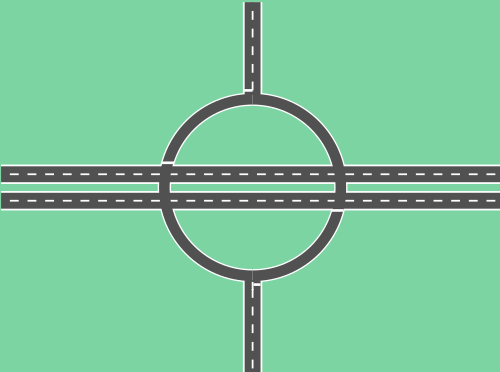 Throughabout
 -
 Throughabout road sign in the Netherlands 51°51′02″N 5°49′54″E / 51.850517°N 5.831576°E / 51.850517; 5.831576
 -
 Throughabout road sign in Australia 31°53′25″S 115°52′12″E / 31.8902952°S 115.8698988°E / -31.8902952; 115.8698988
Only bicycle-pedestrian roundabouts
The same features that make roundabouts attractive for roadway junctions led to their use at junctions of multi-use trails.
The University of California, Davis[129][original research?] and Stanford University, as well as the Cape Cod and Old Colony rail trails have bicycle-pedestrian roundabouts. A roundabout along the Clear Creek Trail in Bloomington, Indiana, connects the main trail to its spur.
Roundabouts are used on off-road bicycle trails in Florida, Colorado, Alaska, and Wisconsin.[130][131][132]
An elevated roundabout is located in Eindhoven, serving pedestrian and bicycle traffic only, above the main conventional roadway intersection. It is known as the Hovenring.
See also
- Complete streets
- Direction of traffic
- History of road transport
- History of street lighting in the United States
- History of roads in Ireland
- Level of service
- Leif Ourston, an early proponent of roundabouts in the United States
- Roundabout Appreciation Society
- Roundabout dog
- Traffic congestion
Notes
- ^ There is also a branch line immediately north of the roundabout going west, and an additional tram stop on that branch.
References
- ^ a b The New Shorter Oxford English Dictionary, Volume 2, Clarendon Press, Oxford (1993), page 2632
- ^ a b c d U.S. Department of Transportation 2013, para 1.5.
- ^ a b c d e f g h i j k l m n Ourston, Leif; Bared, Joe G. (1995). "Roundabouts: A Direct Way to Safer Highways". Public Roads. 59 (2). Federal Highway Administration: 41–49. Retrieved 20 October 2020.
- ^ "Roundabout Benefits". Washington State Department of Transportation. Retrieved 12 July 2014.
- ^ Hesch, Maxine. "Quantitatively Determining the Emissions Reduction Benefits of the Replacement of a Signalized Intersection by a Roundabout" (PDF). New York State Department of Transportation. Retrieved 6 October 2013.
- ^ a b c d "Roundabouts". IIHS-HLDI crash testing and highway safety.
- ^ "Roundabout Rules of the Road". Archived from the original on 9 January 2014. Retrieved 12 January 2014.
- ^ P. M. Wolf, Eugene Henard and the Beginning of Urbanism in Paris, 1900–1914, International Federation for Housing and Planning, The Hague, 1969, cited by Ben Hamilton-Baillie and Phil Jones, Improving traffic behaviour and safety through urban design, Proceedings of ICE – Civil Engineering| volume=158 Issue 5 May 2005 p. 41 "Archived copy" (PDF). Archived from the original (PDF) on 30 July 2007. Retrieved 10 October 2006.
{{cite web}}: CS1 maint: archived copy as title (link) - ^ Verhoeven, Dolly (red.) (2009). De Canon van Nijmegen. Nijmegen: Uitgeverij Vantilt. p. 131. ISBN 9789460040351.
- ^ "Was alles in Görlitz erfunden wurde – Alles-Lausitz.de". Alles-Lausitz.de (in German). Archived from the original on 7 August 2017. Retrieved 5 June 2017.
- ^ http://twofeet.weebly.com/walking-blog/the-five-circles-of-hanchett-park The Five Circles of Hanchett Park, 7 June 2014
- ^ BBC News (2 November 2004). "Roundabout Magic". Retrieved 13 May 2007.
- ^ Letchworth Garden City Heritage Foundation. "Sign of the Times". Archived from the original on 16 October 2006. Retrieved 14 December 2006.
- ^ a b National Academies of Sciences, Engineering (4 December 2010). Roundabouts: An Informational Guide (2nd ed.). doi:10.17226/22914. ISBN 978-0-309-15511-3.
- ^ a b c d e Christine Beldon (17 December 2019). "Why The U.S. Hates Roundabouts". Cheddar. Archived from the original on 11 December 2021. Retrieved 18 April 2021.
- ^ "Frank Blackmore: traffic engineer and inventor of the mini-roundabout". The Times. London. 14 June 2008. Archived from the original on 24 May 2010. Retrieved 15 June 2008.
- ^ Ourston Roundabout Engineering, Inc (13 January 2010). "Leif Ourston receives Frank Blackmore Award". Ourston.com. Archived from the original on 29 October 2013. Retrieved 7 October 2013.
- ^ Clint Pumphrey. "How Roundabouts Work". howstuffworks.com
- ^ "Roundabouts: A Direct Way to Safer Highways | FHWA". highways.dot.gov. Retrieved 15 September 2023.
- ^ a b c d Kooman, Bas (March 2001). "De rotonde. Veilig rondjes rijden?". Kampioen (in Dutch). 116 (3): 65–66.
- ^ Hadley, Jane (22 November 2004). "Getting There: Perks for drivers of hybrid cars? Sorry, and here's why not". Seattle Post-Intelligencer. p. B1. Archived from the original on 22 November 2004. Retrieved 29 February 2024.
- ^ Dahl, Doug (18 January 2021). "With a wink and a nod, a quick left often is drivers' go-to move at calming circles". The Bellingham Herald. Retrieved 29 February 2024.
- ^ a b Tollazzi, Tomaž (2014). Alternative Types of Roundabouts: An Informational Guide. Cham: Springer. p. 110. ISBN 9783319090849. Retrieved 18 April 2021.
- ^ a b c Keh, Andreh (18 November 2010). "European Import Has Cars Spinning. Heads, Too". The New York Times. Retrieved 19 November 2010.
- ^ Wylie, Ian (19 October 2015). "'Traffic lights are so dictatorial' ... but are roundabouts on the way out?". The Guardian. Retrieved 13 February 2020.
- ^ Wright, Lucas (18 September 2019). "Highlighting the first modern roundabouts in the country during National Roundabout Week". KLAS. Retrieved 29 February 2024.
- ^ Roselli, Dayna (18 April 2007). "Roundabouts". lasvegasnow.com. Archived from the original on 26 March 2012. Retrieved 14 October 2014.
- ^ a b Tom Geoghegan (1 July 2011). "Is the British roundabout conquering the US?". BBC website. Retrieved 1 July 2011.
- ^ "Modern Roundabout Practice in the United States" (PDF).
- ^ Retting, Richard A.; Kyrychenko, Sergey Y.; McCartt, Anne T. (2007). "Long-Term Trends in Public Opinion Following Construction of Roundabouts". Journal of the Transportation Research Board. 2019: 219–224. doi:10.3141/2019-26. S2CID 110914100.
- ^ "WSDOT – Washington's Roundabouts". 11 October 2016. Archived from the original on 11 October 2016. Retrieved 17 October 2018.
- ^
"Roundabouts: an informational guide" (PDF). Turner-Fairbank Highway Research Center. 16 November 2017. Archived from the original on 12 January 2009. Retrieved 5 December 2017.
{{cite web}}: CS1 maint: bot: original URL status unknown (link) - ^ "What lane should I use on a roundabout?". AXA.ie. AXA. 16 November 2017. Retrieved 16 November 2017.
- ^ "New Jersey roundabouts" (PDF).
- ^ Capuzzo, Jill P. (25 November 2007). "A Shift, but for Some Drivers, a Vicious Circle". The New York Times. Retrieved 27 March 2010.
- ^ "Drum Hill Rotary" (Map). Google Maps.
- ^ "Roundabout opens in north Japan after lesson learned from 2011 quake, tsunami". Mainichi Daily News. 6 January 2020. Retrieved 20 November 2023.
- ^ American Heritage Archived 26 December 2013 at the Wayback Machine ("roundabout: Chiefly British A traffic circle."), Random House ("roundabout: Chiefly Brit. See traffic circle."), Merriam-Webster("roundabout, noun: British: rotary 2"; "rotary 2: a road junction formed around a central circle about which traffic moves in one direction only—called also circle, traffic circle)Macmillan "roundabout: a circular area where three or more roads meet that you have to drive around in one direction in order to get onto another road. The American word is traffic circle or rotary.", [1] ("roundabout: UK (US traffic circle)), Concise Oxford (rotary: N. Amer. a traffic roundabout.)
- ^ "Safety Aspects of Roundabouts – FHWA Safety Program". 3 September 2014. Archived from the original on 3 September 2014. Retrieved 17 October 2018.
- ^ "General Law – Part I, Title XIV, Chapter 89, Section 8". malegislature.gov. Retrieved 17 October 2018.
- ^ "Rhode Island Driver's Manual" (PDF). Dmv.ri.gov. Retrieved 17 October 2018.
- ^ "Scottish words of the week: The Dundee dialect". www.scotsman.com. 4 October 2013. Retrieved 3 August 2020.
- ^ "Revealed: What is the most dangerous roundabout in Birmingham?". www.birminghammail.co.uk. 26 August 2016. Retrieved 15 September 2023.
- ^ Jersey, States of. "Government of Jersey". gov.je.
- ^ Intersection Safety Roundabouts – Safety – Federal Highway Administration. February 2010. Archived from the original on 17 April 2010. Retrieved 17 October 2018.
- ^ Kittleson & Associates. "Kansas Roundabout Guide: A Supplement to FHWA's Roundabouts: An Informational Guide" (PDF). Kansas Department of Transportation. Retrieved 26 August 2009.
- ^ "Driver manual" (PDF). Retrieved 13 August 2021.
- ^ Commonwealth of Massachusetts, Registry of Motor Vehicles. "Sharing the Road: A User's Manual for Public Ways". Retrieved 13 May 2009.
- ^ "Vehicle & Traffic Law – Right of Way". 3 July 2011. Archived from the original on 3 July 2011. Retrieved 17 October 2018.
- ^ a b c "Index – Roundabout: An Informational Guide, June 2000 – FHWA-RD-00-067". Fhwa.dot.gov. Retrieved 17 October 2018.
- ^ TSM https://en.wikisource.org/wiki/Traffic_Signs_Manual/Chapter_5/2009/8
- ^ Shashi S. Nambisan, Venu Parimi (March 2007). "A Comparative Evaluation of the Safety Performance of Roundabouts and Traditional Intersection Controls". Institute of Transportation Engineers. Retrieved 27 November 2007.
- ^ Underlien Jensen, Søren (November 2012). "Rundkørsler og trafiksikkerhed" (PDF). Trafik & Veje (in Danish): 26–29.
- ^ sep 2020, Clock 20; Journalist, kl 09:01 Bemærk: Artiklen er mere end 30 dage gammel Sebastian Myrup Hansen. "Renovering af omdiskuteret rundkørsel er i gang - ikke godt nok mener kørelærer". TV 2 Lorry (in Danish). Retrieved 27 January 2022.
{{cite web}}: CS1 maint: numeric names: authors list (link) - ^ Hansen, Winnie (2 June 2019). "Spørg Fagfolket: Hvorfor skal øen i midten af rundkørslen være så høj?". Ingeniøren (in Danish). Vejdirektoratet.
analysis of 332 roundabouts. It was very clear that if the height in the middle of the roundabout was over two meters, then it was much safer than other designs. The accident rate was significantly lower in the high roundabouts
- ^ "Art In Public Places, Bend, Oregon". Art in Public Places. Archived from the original on 9 May 2008. Retrieved 2 November 2013.
- ^ "Pillar of art" (PDF). Art in Public Places. Archived from the original (PDF) on 3 November 2013. Retrieved 2 November 2013.
- ^ "Fuerteventura, art on the roads: roundabouts as galleries". Roberto Alborghetti. 2 July 2012. Retrieved 2 November 2013.
- ^ "Photographs of French roundabouts" (Map). Google Maps.
- ^ a b c "Roundabout photographs from The Netherlands, Belgium, Germany and Austria" (Map). Google Maps.
- ^ "Roundabout photographs from Italy" (Map). Google Maps.
- ^ "Roundabout photographs from Spain" (Map). Google Maps.
- ^ a b "Unusual road roundabouts: artistic, and otherwise. A collection of more than 2000 photographs, by almost 200 amateur photographers, from all over the world". Panoramio: Roundabouts. www.panoramio.com. Archived from the original on 3 November 2013. Retrieved 2 November 2013.
- ^ "Roundabout / Kreisverkehr – streets with a roundabout / Straßen mit einem Kreisverkehr". Flickr (in English and German). www.flickr.com. Retrieved 2 November 2013.
- ^ "Inventory of French roundabouts" (in French). Marc Lescuyer. Archived from the original on 11 November 2008. Retrieved 1 January 2010.
- ^ "Section 7: Laws and Rules of the Road". California DMV.
- ^ "Facts & figures". swov.nl.
- ^ a b "Modern Roundabouts, an Informational Guide". Federal Highway Administration Research and Technology. Retrieved 15 September 2015.
- ^ "FHWA - MUTCD - 2003 Edition Chapter 3B2". Federal Highway Administration (FHWA).
- ^ R. Schnüll, J. Lange, I. Fabian, M. Kölle, F. Schütte, D. Alrutz, H.W. Fechtel, J. Stellmacher-Hein, T. Brückner, H. Meyhöfer: Sicherung von Radfahrern an städtischen Knotenpunkten [Safeguarding bicyclists in Urban Intersections], Bericht der Bundesanstalt für Straßenwesen zum Forschungsprojekt 8952, 1992
- ^ Vortragsfolien Radverkehr Scroll to the section labelled "Kreisverkehr". A translation of the text reads: Graphic from Sicherung von Radfahrern an städtischen Knotenpunkten [Safeguarding cyclists in Urban Intersections], (BASt, 1992). Accident numbers in large circular junctions with different bicycle facilities show: 1. Why there should be no pathways or bike lanes at these junctions; 2. Even when cyclists use the roadway, their risk is relatively high at these junctions.
- ^ Maycock, G., and Hall, R. D. (1984). "Accidents at 4-Arm Roundabouts." TRRL1120, Transport and Road Research Laboratory (TRRL), Crowthorne, England.
- ^ "Roundabouts | ADOT". azdot.gov.
- ^ a b Design manual for bicycle traffic. Rik de Groot, vervoer en infrastructuur CROW kenniscentrum voor verkeer. Ede, The Netherlands. 2016. pp. 147–148. ISBN 978-90-6628-659-7. OCLC 972096448.
{{cite book}}: CS1 maint: location missing publisher (link) CS1 maint: others (link) - ^ "UK's first Dutch-style roundabout welcomed by road safety campaigners - Highways Industry". Highways Industry. 7 August 2020. Retrieved 29 July 2024.
- ^ "Ireland's first Dutch-style roundabout opened in Dublin 15 -". IrishCycle.com. 29 May 2023. Retrieved 29 July 2024.
- ^ Taylor, M.P., Barton, E.V., Bliss, J. and O'Brien, A.P. (1993). Effectiveness Audit of ARRB Intersection Capacity Research. Research Report ARR 242. ARRB Transport Research Ltd, Vermont South, Australia. Archived from the original on 27 February 2016.
{{cite book}}: CS1 maint: location (link) CS1 maint: multiple names: authors list (link) CS1 maint: numeric names: authors list (link) - ^ TRB (2016). Highway Capacity Manual, Sixth Edition: A Guide for Multimodal Mobility Analysis. Transportation Research Board, National Research Council, Washington, DC, US.
{{cite book}}: CS1 maint: numeric names: authors list (link) - ^ TRB (2010). Roundabouts: An Informational Guide. NCHRP Report 672. Transportation Research Board, National Research Council, Washington, D.C., US, in cooperation with US Department of Transportation, Federal Highway Administration. doi:10.17226/22914. ISBN 978-0-309-15511-3.
{{cite book}}: CS1 maint: location (link) CS1 maint: location missing publisher (link) - ^ Pochowski, Alek; Paul, Andy; Rodegerdts, Lee A. (2016). Roundabout Practice, A Synthesis of Highway Practice. National Cooperative Highway Research Program, NCHRP SYNTHESIS 488. Washington DC, US.: Transportation Research Board. doi:10.17226/23477. ISBN 978-0-309-27208-7.
{{cite book}}: CS1 maint: location (link) - ^ Nambisan, Shashi S.; Parimi, Venu (March 2007). "A Comparative Evaluation of the Safety Performance of Roundabouts and Traditional Intersection Controls". Institute of Transportation Engineers.
- ^ "Status Report" (PDF). Archived from the original (PDF) on 14 July 2014. Retrieved 9 June 2014.
- ^ Richtmeyer, Richard (6 January 2008). "Safer Roundabouts Sprouting Up All Over New York, Nation". Associated Press. Archived from the original on 15 December 2012. Retrieved 10 January 2008.
- ^ "Roundabouts - Topic overview". Insurance Institute for Highway Safety.
- ^ Wijnands, J.S.; Zhao, H.; Nice, K.A.; Thompson, J.; Scully, K.; Guo, J.; Stevenson, M. (2020). "Identifying safe intersection design through unsupervised feature extraction from satellite imagery". Computer-Aided Civil and Infrastructure Engineering. 36 (3): 346–361. arXiv:2010.15343. doi:10.1111/mice.12623. S2CID 225103031. PDF
- ^ Wilke, A. and Koorey, G. (2001). How Safe are Roundabouts for Cyclists? In TranSafe Issue 5, April 2001. Wellington, NZ. PDF Archived 15 October 2008 at the Wayback Machine
- ^ "Crash analysis system". Retrieved 29 November 2007.
- ^ Campbell, D., Jurisich, I., Dunn, R. 2006. Improved multi-lane roundabout designs for cyclists. Land Transport New Zealand Research Report 287. 140 pp. PDF
- ^ Pedestrian Access to Modern Roundabouts: Design and Operational Issues for Pedestrians who are Blind retrieved 6/26/2010 access-board.gov Archived 31 March 2012 at the Wayback Machine
- ^ Bill Baranowski, P.E., Pedestrian Crosswalk Signals at Roundabouts: Where are they Applicable?
- ^ "| Guinness World Records".
- ^ "History of Roundabouts". Archived from the original on 27 January 2008. Retrieved 29 November 2007.
- ^ Transport for London https://tfl.gov.uk/info-for/media/press-releases/2014/november/tottenham-hale-improvement-works-complete
- ^ Rhodes, Belinda (21 June 2008). "Frank Blackmore Determined, maverick traffic engineer who invented the mini-roundabout". The Guardian. Retrieved 7 October 2013.
- ^ "The Highway Code – Roundabouts". Retrieved 14 May 2009. Section 188, referring to Road Traffic Act 1988, Section 36, and Traffic Signs Regulations & General Directions 2002, Regulations 10(1) & 16(1)
- ^ "Turborotonde en turboplein: ontwerp, capaciteit en veiligheid" [Turbo Roundabout and Turbo Circle; Design, Capacity and Safety] (in Dutch). Delft University of Technology. 8 January 2013. Retrieved 16 October 2014.
- ^ "Turborotondes - CROW". Archived from the original on 26 September 2017. Retrieved 9 July 2017.
- ^ "Benefits of Turboroundabouts". Transoft Solutions Inc. 2014. Retrieved 16 October 2014.
- ^ a b Vos, Christiaan (31 January 2016). "Effecten realisatie turborotonde onderzocht" [Effects research of turbo roundabouts]. Verkeer – Verkeersveiligheid – Vorm (Traffic, Safety, Form) (in Dutch). Dirk de Baan. Archived from the original on 28 January 2017. Retrieved 28 January 2017.
- ^ Isaak Yperman; Ben Immers (2003). "Capacity of a turbo-roundabout determined by micro-simulation". Katholieke Universiteit Leuven, Department of Civil Engineering – Transportation Planning and Highway Engineering. Archived from the original (pdf) on 27 December 2016. Alt URL
- ^ "Manual on Uniform Traffic Control Devices for Streets and Highways – Part 3: Markings" (PDF). U.S. Department of Transportation – Federal Highway Administration. 2003.
- ^ For sources and references see the separate article on this tunnel and its roundabout.
- ^ "Video: Eerste rit over het nieuwe knooppunt Joure". Leeuwarder Courant. 13 October 2017.
- ^ UK Department for Transport, Signal Controlled Roundabouts LTN 1/09
- ^ Ibanez, Guillermo (2020). "Synchronous Roundabouts with Rotating Priority Sectors (SYROPS): High Capacity and Safety for Conventional and Autonomous Vehicles". Electronics. 9 (10): 1726. doi:10.3390/electronics9101726. hdl:10017/44928.
- ^ "Frank Blackmore: traffic engineer and inventor of the mini-roundabout". The Times. London. 14 June 2008. Archived from the original on 24 May 2010. Retrieved 15 June 2008.
- ^ Swindon's Magic Roundabout from the air, retrieved 23 March 2022
- ^ Brits vote on the best and worst roundabouts, Easier.com. 20 December 2005, retrieved 18 January 2008
- ^ "World's worst junctions revealed". Auto Express.
- ^ 10 Scariest Junctions in the UK, BBC, 27 November 2009.
- ^ "High Wycombe" (Map). Google Maps.
- ^ "Hatton Cross" (Map). Google Maps.
- ^ "SABRE: Magic Gyratory". 8 November 2013. Retrieved 8 November 2013.
- ^ a b "Archived copy" (PDF). Archived from the original (PDF) on 19 October 2019. Retrieved 19 October 2019.
{{cite web}}: CS1 maint: archived copy as title (link) - ^ Vítězné náměstí, Prague trams fun web
- ^ "Roundabout" (Map). Google Maps. Retrieved 15 January 2012.
- ^ "Jensen Beach Roundabouts Charrette". Archived from the original on 21 November 2008. Retrieved 16 October 2007.
- ^ "145.039044269836,-37.9447586507931". Australia Mapsearch.
- ^ "144.9930580000&,-37.9200150000". Australia Mapsearch.
- ^ "Der Driescher Kreisel". Archived from the original on 27 September 2011.
- ^ "Blenheim Roundabout" (Map). Google Maps. Retrieved 15 January 2012.
- ^ "Kumara Junction Roundabout" (Map). Google Maps. Retrieved 15 January 2012.
- ^ "Haydock Island in Merseyside" (Map). Google Maps.
- ^ Astley/Boothstown border "Roundabout" (Map). Google Maps.
{{cite map}}: Check|url=value (help) - ^ "Winnersh, Berkshire" (Map). Google Maps.
- ^ "Mytongate on the A63 in Hull" (Map). Google Maps.
- ^ "Morley and Alexander Drive" (Map). Google Maps.
- ^ "Cómo circular en una Glorieta Partida (raqueta)". Autoescuela Miguel Blog (in Spanish). Archived from the original on 17 October 2014. Retrieved 17 October 2014.
Explanation in the website of a driving school
- ^ "Davis, Ca" (Map). Google Maps.
- ^ Shaw, Jeffrey and Moler, Steve, Bicyclist- and Pedestrian-Only Roundabouts, Public Roads magazine, January/February 2009 Archived 10 May 2009 at the Wayback Machine
- ^ "Federal Highway Administration Research and Technology-- – Federal Highway Administration". Archived from the original on 23 September 2006. Retrieved 5 September 2006.
- ^ "Bicycle roundabout sits at intersection of 3 bike paths". The Capital Times.
Sources
- U.S. Department of Transportation (2013). "Roundabouts: an Informational Guide" (PDF).
- Stenquist, Paul (20 August 2020). "All About Roundabouts". The New York Times. Retrieved 29 August 2020.
External links

Wikimedia Commons has media related to Roundabouts.
- City of Carmel, Indiana, USA, Roundabouts page
- Car Free America Roundabout Safety and Design Guide
- Video of Highway Roundabout in Canada
- TRL, The UK's Transport research Laboratory
- Modern Roundabouts – Geocoded National Database
- Mini-roundabouts – Getting them Right
- Turbo Roundabout Simulation
- Roundabout Benefits from the Washington State Department of Transportation
- Highway Roundabouts from the Ministry of Transportation of Ontario
- Roundabouts Now
- Benefits of a Turboroundabout
- Modern Roundabout Practice in the United States from Transportation Research Board
- Proceedings from the Transportation Research Board Standing Committee on Roundabouts (ANB75)