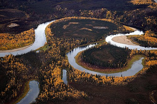
An example of a banco, created when a meander is cut off by a new, shorter channel, leaving a cut-off section of land surrounded by a U-shaped (oxbow) lake
The Banco Convention of 1905 between the United States and Mexico allowed, in the event of sudden changes in the course of the Rio Grande (as by flooding), for the border to be altered to follow the new course.[557] The sudden changes often created bancos (land surrounded by bends in the river that became segregated from either country by a cutoff, often due to rapid accretion or avulsion of the alluvial channel), especially in the Lower Rio Grande Valley. When these bancos are created, the International Boundary and Water Commission investigates if land previously belonging to the United States or Mexico is to be considered on the other side of the border.[558] In all cases of these adjustments along the Rio Grande under the 1905 convention, which occurred on 37 different dates from 1910 to 1976, the transferred land was minuscule (ranging from 1-acre (4,000m2) to 646 acres (261ha)) and uninhabited.[559][560][561]
↑Even though there were borders drawn as far as the Mississippi River, the early United States was only settled along the east coast. As the states were surveyed, these lines were solidified, though often missing their intended mark. By the time the country was surveying its western acquisitions in the mid-19th century, the process had improved and was being conducted through the United States General Land Office; the western borders were rarely controversial. Border surveys are given their own entry in this list if they were performed east of the Mississippi River, involved legislation, or were otherwise notable; the rest are detailed in footnotes in the relevant statehood or cession entries.
↑The Connecticut General Assembly adopted the name "State of Connecticut" during their session beginning October 10, 1776.[2][3]
↑Georgia formally became the "State of Georgia" with the adoption of their constitution on February 5, 1777.[8][9]
↑Maryland formally became the "State of Maryland" with the adoption of their constitution around November 11, 1776.[11][12]
↑The Massachusetts Bay House of Representatives adopted the name "State of Massachusetts Bay" on December 7, 1776.[14][15]
↑New Hampshire formally adopted the name "State of New Hampshire" on September 11, 1776.[17][B]
↑New Jersey formally adopted the name "State of New Jersey" on September 20, 1777.[21][C]
↑New York formally became the "State of New York" with the adoption of their constitution on April 20, 1777;[24] the New York Provincial Congress adopted the name "Convention of the Representatives of the State of New-York" on July 10, 1776.[25][26]
↑North Carolina formally became the "State of North Carolina" with the adoption of their constitution on December 18, 1776.[28][29]
↑Pennsylvania was first formally referred to as the "State of Pennsylvania" on July 25, 1776.[31][32]
↑Rhode Island formally adopted the name "State of Rhode Island and Providence Plantations" on July 20, 1776.[34][35]
↑South Carolina formally became the "State of South Carolina" with the adoption of their constitution on March 19, 1778.[39][40]
↑Virginia formally became the "Commonwealth of Virginia" with the adoption of their constitution on June 29, 1776.[42][43]
↑Sources disagree on whether the constitution took effect on September 20[50] or September 21.[51]
↑Sources disagree on whether this formally occurred on January 15[54] or January 17.[55]
↑The New York towns petitioning to join Vermont were: "Black-Creek" (unknown; possibly is or is near Hebron), Cambridge, Fort Edward, Granville, "Greenfield" (unknown; there is a town named Greenfield but it is west of the Hudson River, which was explicitly the western extent of the West Union), Hoosick, Kingsbury, "Little Hoosack" (unknown; presumably near Hoosick), Saratoga, "Scorticook" (possibly Schaghticoke), Skeensborough (now Whitehall), and "Upper-White-Creek" (probably White Creek).[66]
↑The Supreme Court noted in 1933 that this occurred on February 22,[E] but a 1823 printing of the Vermont State Papers indicates it was February 23.[69]
↑New York made the cession on March 1, 1781, and Congress accepted it on October 29, 1782.[F]
↑It is unclear from where this claim came; many sources state that New York had surrendered it, but few elaborate on how it was obtained, beyond some saying it was a cession from the Six Nations.[73][74]
↑Virginia made the cession during the session beginning October 20, 1783, and Congress accepted it on March 1, 1784.[G]
↑The agreement was made provisionally on August 31, 1779;[80] approved by Virginia on June 23, 1783; and approved by Pennsylvania on April 1, 1784.[81]
↑The treaty was signed September 3, 1783, ratified January 14, 1784, and entered into force May 12, 1784.[H]
↑The treaty established the boundaries of the new country, from the Bay of Fundy: up the "St. Croix River" (which river this referred to was disputed) to its source; north to the height of the land (the "Northwest Angle of Nova Scotia"); along the height of the land to the "northwesternmost Head" of the Connecticut River (which source this referred to was disputed); down that to 45° north; west to the St. Lawrence River; up that to the Great Lakes, through Lake Ontario, the Niagara River, Lake Erie, the Detroit River, Lake St. Clair, the St. Clair River, Lake Huron, and Lake Superior; to "Long Lake" (which lake this referred to was disputed) towards the Lake of the Woods; to the northwest angle of the Lake of the Woods; then west to the Mississippi River. However, the Lake of the Woods was north of the source of the Mississippi River; maps universally show this undefined boundary as a straight line, nearly straight south, between the two points. From there, it followed the Mississippi River down to 31° north; east to the Chattahoochee River; down that to the confluence of the Chattahoochee and Flint rivers; a line from there to the source of the St. Mary's River; then down that to the Atlantic Ocean.[H]
↑All sources show Georgia enlarging to fill the new borders,[86] but an act in 1798 referred to the federal and Georgia governments having "interfering claims" over the region.[I]
↑There is some confusion over if the state was named Franklin or Frankland, complicated by another attempt at a state in the region using the name Frankland.[88]
↑Massachusetts made the cession on November 13, 1784, and Congress accepted it on April 19, 1785.[K]
↑Connecticut made the cession on May 11, 1786, and Congress accepted it on September 14, 1786.[L]
↑Connecticut's ceded claim was a strip west of 120 miles west of Pennsylvania (the western border of its Western Reserve) stretching to the Mississippi River, bounded by 41° north and the southern edge of Massachusetts' western claim, roughly 42°2′ north.[74]
12345678910This is the date used to consider the border as formally surveyed, as no dates of government approval are known.
↑Massachusetts noted in a resolve passed on November 21, 1787, that the surveyors agreed on their report on July 21, 1787.[O]
↑South Carolina made the cession on March 8, 1787,[P] and Congress accepted it on August 9, 1787.[Q]
↑North Carolina made the cession on December 22, 1789,[74] and the federal government accepted it on April 2, 1790.[T]
↑Surveyor Andrew Ellicott wrote several letters on October 11, 1790, referring to his work having been completed the previous day,[113][114] but no dates of government approval are known.
↑The district did not have a formal name; in September 1791, the commissioners in charge of planning the city would term it the "Territory of Columbia".[117]
↑Maryland made the cession on December 23, 1788,[X] and, after the district's borders were set, formally ceded the specific parcel on December 19, 1791.[Y] Virginia made the cession on December 3, 1789.[120]
↑The act approving the sale was approved on January 3, 1792.[Z] President George Washington presented the deed to Pennsylvania on March 3, 1792,[122] and most sources use this date for the formal transfer;[52][123] however, some use April 23.[124][125]
↑Virginia agreed to cede the territory to the federal government on December 18, 1789.[AA]
↑On February 19, 1803, the president signed an act approving Ohio's boundaries and constitution;[AJ] however, Congress never passed a formal resolution admitting it as a state. When this was noticed in 1953, Congress retroactively set the date of statehood to March 1, 1803,[AK] the date the state legislature first met.[147]
↑The western border of Ohio had been surveyed in 1799 as far north as Fort Recovery.[148]
↑The survey was approved by Virginia on January 22, 1803, and by Tennessee on November 3, 1803.[AM]
↑The final report of the commissioners was delivered on November 30, 1803;[155] no dates of government approval are known.
↑The treaty was signed April 30, and ratified and entered into force October 21, 1803.[AN] The formal turnover occurred in New Orleans on December 20, 1803,[158] and would be recognized in St. Louis in Upper Louisiana on March 10, 1804, which would be known as known as Three Flags Day.[159]
↑There was some question as to whether the purchase also included the basins of the Missouri River and the Red River of the North,[161] but the question was not relevant before the Treaty of 1818 definitively settled the border.
↑The northern border of Louisiana had been surveyed in 1806.[171]
↑The cession was approved by the federal government on April 14, 1812,[AV] and accepted by Louisiana on August 4, 1812.[AW]
↑Indiana was defined as the territory north of the Ohio River and east of the Wabash River, but while the territory's line turned north at Post Vincennes, the state's border continued up the Wabash until it reached the point where a line drawn north from Post Vincennes would last intersect the river as it weaved back and forth. The northern border of the state was a line east from 10 miles north of the southern tip of Lake Michigan, until it reached the meridian that formed Ohio's western border, which was a line drawn north from the mouth of the Great Miami River.[150]
↑The treaty was signed October 20, 1818, ratified January 28, 1819, and entered into force January 30, 1819.[BC]
↑Oregon Country had no defined northern limit; it can be assumed that it did not encroach upon Russian-held lands, and 54°40′ north would be established as the border in 1825.
↑The compact between the states was signed on February 2, 1820; approved by Kentucky on February 11, 1820;[BI] and approved by the federal government on May 12, 1821.[BJ]
↑Alabama's southwestern border was defined as a north-south line, but the statehood act called for a survey to confirm if this encroached on counties established by Mississippi; it was found to do so, and the southern terminus of the border was moved about 3.8 miles to the east.[89]
↑The treaty was signed February 22, 1819, and ratified and entered into force February 22, 1821.[BK]
↑The new Missouri–federal border was, from the mouth of the Des Moines River: up the river to a point west of the Des Moines Rapids on the Mississippi River, west to a point north of the mouth of the Kansas River, then south.[174] The northern border had been surveyed in 1816,[202] and the survey of the western border south of the Kansas River would be completed on October 16, 1823.[202][203]
↑The survey was approved by North Carolina during the session beginning November 19, 1821;[BM] no date of approval by Tennessee is known.
↑The survey was approved by Kentucky on November 13, 1821, and by Tennessee on November 22, 1821.[194]
↑The treaty was signed April 17, 1824, ratified January 7, 1825, and entered into force January 11, 1825.[BP]
↑The treaty was signed May 6, and ratified May 28, 1828.[BQ]
↑The new Arkansas Territory–federal border was, from the north: a line from the southwestern corner of Missouri to a point on the Arkansas River "100 paces east" of Fort Smith, as the border of the lands of the Eastern Choctaw, then south.[185] However, the Arkansas Supreme Court determined in 1909 that the "100 paces east" was a clerical error, and that logically it should have said "100 paces west".[BR] The western border of Arkansas Territory south of Fort Smith had been surveyed in 1825.[210]
↑The survey was approved by Maine on February 28, 1829, and by New Hampshire on July 1, 1829.[211]
↑The survey was approved by Kentucky on February 9, 1828, and by Tennessee on December 20, 1831.[213]
↑Authorities with Indian Stream communicated to the British government on August 5, 1835, that they had accepted New Hampshire jurisdiction;[216] a resolution to this effect was approved by the citizens of Indian Stream on April 2, 1836.[215]
↑The western border north of Fort Smith had been surveyed in 1831.[210]
↑The northern half of the Indiana–Ohio border was surveyed in 1817 along with the northern border.[152]
↑The new Michigan Territory–Wisconsin Territory border was, from Lake Superior: up the Montreal River to Lac Vieux Desert; a line to the source of the Menominee River; then down that to Green Bay. However, this definition was impossible, as the Montreal River ended long before it reached Lac Vieux Desert.[218]
↑The cession was approved by the federal government on June 7, 1836,[BY] accepted by Missouri on December 16, 1836,[BZ] and proclaimed by the president on March 28, 1837.[CA]
↑The survey was approved by Georgia on December 8, 1826,[227] and by Alabama on January 27, 1840.[228]
↑The treaty was signed August 9, ratified August 22, and entered into force October 13, 1842.[CF]
↑The new northeastern border was, from Passamaquoddy Bay: up the St. Croix River to its source; north to the St. John River; up that to the St. Francis River; up that to its source outlet at Lake Pohenegamook; southwest to the northwest branch of the St. John River; a line from there to where the St. John River crosses 46°25′ north; up the river to its source; along the highlands to the source of Halls Stream, then down that to 45° north.[231]
↑Texas formally handed over sovereignty to the United States in a ceremony on February 19, 1846.[233]
↑While many sources state that Mexico recognized the independence of the eastern portion of Texas, the treaties were rejected by the Mexican government.
↑The treaty was signed June 15, ratified June 19, and entered into force July 17, 1846.[CI]
↑The survey of the northern border would be completed on August 9, 1852.[237][238]
↑The retrocession act was approved on July 9, 1846,[CK] residents of Alexandria County were proclaimed by the president on September 7, 1846, to have agreed to it,[CL] and Virginia took possession on March 20, 1847.[CM]
↑Article III of the Treaty of 1908 noted that the survey was completed on June 28, 1847.[CN]
↑The treaty was signed February 2, ratified March 16, and entered into force May 30, 1848.[CR]
↑The new international border was, from the Rio Grande: along the southern and western border of New Mexico until it met the Gila River; down that to the Colorado River; then a line to a point one league south of the port of San Diego. However, the southern border of New Mexico was in question, with the American claim being 31°52′ north, and the Mexican claim being 32°22′ north.[247]
↑The federal government consented on July 5, 1848,[CV] and Texas approved on November 24, 1849.[251]
↑The treaty was signed December 30, 1853, ratified June 29, 1854, and entered into force June 30, 1854.[DD]
↑The new international border was, starting from where the Rio Grande crosses 31°47′ north: west 100 miles; south to 31°20′ north; west to 111° west; a line to a point on the Colorado River 20 miles below the mouth of the Gila River; then up the Colorado River.[267]
↑Massachusetts made the cession on May 14, 1853, New York accepted it on July 21, 1853, the federal government consented on January 8, 1855,[DF] and the cession was proclaimed on January 11, 1855.[269]
↑Haiti claimed the island by name in its 1874 constitution,[DJ] and had considered it included in the "adjacent islands" claimed since the 1801 constitution.[DK]
↑The new Oregon–Washington Territory border was, from the north, up the Snake River to the mouth of the Owyhee River, then south.[262] The border with California would be surveyed in 1870.[253]
↑The law admitting the state required a presidential proclamation before it was to take effect,[DT] which sources say took place on May 21, 1861;[311] the closest known primary document is a statement from Jefferson Davis on July 20 stating that the proclamation had been made.[312]
↑The treaty was signed October 2,[DY] and ratified December 21, 1861.[322]
↑The treaty was signed October 4,[DZ] and ratified December 21, 1861.[324]
↑The full description of the native party to the treaty was, "the Seneca tribe of Indians, formerly known as the Senecas of Sandusky, and the Shawnees of the tribe or confederacy of Senecas and Shawnees, formerly known as the Senecas and Shawnees of Lewistown, or the mixed bands of Senecas and Shawnees."[325]
↑The treaty was signed October 7,[EA] and ratified December 23, 1861.[328]
↑The treaty was signed August 1,[EB] and ratified December 23, 1861.[330]
↑The treaty was signed July 12,[EC] and ratified December 31, 1861.[332]
↑The full description of the native party to the treaty was, "The No-co-ni, Ta-ne-i-weh, Ya-pa-rih-ca and Co-cho-tih-ca bands of the Ne-um, called by the white men the Comanches of the Prairies and the Staked Plain."[336]
↑There were two treaties with the Comanche, one with the "Comanches and other Tribes and Bands"[ED][ds] and one with the "Comanches of the Prairies and Staked Plain."[EE][dt] Both were signed on August 12, 1861, and ratified on December 31, 1861.[337]
↑The treaty was signed July 10,[EF], and ratified December 31, 1861.[332]
↑The treaty was signed October 4,[EG] and ratified December 31, 1861.[340]
↑The decree transferred land from the left bank of the Blackstone River to Rhode Island, including what is now East Providence, in exchange for land around Fall River being transferred to Massachusetts.[341]
↑The Restored Government of Virginia gave its consent on May 13, 1862, the act admitting West Virginia was approved on December 31, 1862,[EK] and the president proclaimed on April 20, 1863, that it would become a state in sixty days.[EL]
↑The Restored Government of Virginia gave its consent on January 31, 1863,[EM] West Virginia accepted on August 5, 1863,[EN], and the federal government consented after-the-fact on March 10, 1866.[EO]
↑The Restored Government of Virginia gave its consent on February 4, 1863,[EP] West Virginia accepted on November 2, 1863,[EQ] and the federal government consented after-the-fact on March 10, 1866.[EO]
↑The cession was approved by the federal government on May 5, 1866;[ET] the receipt of this specific grant was pre-approved in the Nevada constitution.[EU]
↑The survey was approved by Florida on February 8, 1861,[EW] and by Georgia on December 13, 1866.[EX] The federal government would acknowledge the surveyed border on April 9, 1872.[EY]
↑The cession was approved by the federal government on May 5, 1866,[ET] and accepted by Nevada on January 18, 1867.[EZ]
↑The survey of the full eastern border would be completed on December 26, 1870.[249][361]
↑The treaty was signed March 30, ratified May 28, and entered into force June 20, 1867.[FC] The cession was formally handed over on October 18, 1867.[364]
↑The borders of the Department of Alaska were, from the Dixon Entrance: Up the Portland Channel to 56° north; then along the "summit of the mountains situated parallel to the coast" (the definition of which was disputed) to 141° west; then north.[267]
↑The organic act specified it would take effect after the territorial government was organized;[FJ] while this would not occur until May 19, 1869,[367] all sources use July 25, 1868, as the creation date.
↑The cession was approved by the federal government on April 28, 1870,[FP] and accepted by Nebraska on February 9, 1871.[FQ]
↑Articles 34 and 35 of the Treaty of Washington[FS] provided for the dispute to be arbitrated by Wilhelm I, who delivered his decision on October 21, 1872.[236]
↑Two other islands were bonded on September 13, 1880: "De Anes", with the coordinates of Isla de Aves, but which was acknowledged by the United States in 1859 to belong to Venezuela, so it is assumed nothing ever came of this bond, and no further claim was ever made by the United States;[385] and Serranilla Bank, being bonded a second time.[371]
↑The cession was approved by the federal government on March 18, 1882,[FX] and accepted by Nebraska on May 23, 1882.[FY]
↑Scorpion Reef was bonded under the name "Alacrans Islands, viz, Perez Island, Chica Island, and Pajoras Island."[370]
↑This is the date the protectorate was proclaimed on Rakahanga;[392] Bryan says the islands were annexed on August 9, 1889.[393]
↑The General Land Office had surveyed the eastern border with Minnesota in 1860,[237] and the southern border with Nebraska west of the Keya Paha River in 1874;[263] and would survey east of the river in 1893,[263] and the border between the new states in 1892.[302]
↑The new Oklahoma Territory–federal border was, from where the Red River meets 98° west: north to the Canadian River; down that to Seminole land; north along that border to the North Canadian River; down that to Creek land; north and east along that border to 96° west; then north. This omits the Cherokee Outlet, whose complex borders separated the main portion of Oklahoma Territory from the former Public Land Strip.[399]
↑The General Land Office had surveyed the border with Oregon in 1868;[262] the border with Nevada in 1873;[304] the border with Washington in 1873, though it stopped short by one mile and would be completed in 1908;[400] the eastern border with Wyoming in 1874;[352] and would survey the linear border with Montana in 1899,[401] and the montane border in 1906.[401]
↑The General Land Office had surveyed the border with Nebraska in 1869;[263] the southern border in 1873;[352] the western border in 1874;[352] the eastern border in 1877;[264] and the northern border in 1880.[352]
↑The ship that proclaimed the protectorates voyaged from May to July 25, 1892;[405] it is unknown what specific date the proclamations occurred on.
↑The Oklahoma Organic Act provided that when the "interest of the Cherokee" in the land was extinguished, and proclaimed by the president, then the land would automatically become part of Oklahoma Territory.[GF] This was done via treaty, signed on December 19, 1891,[407] and ratified on March 3, 1893.[GJ] It was proclaimed by the president on August 19, 1893, to take effect on September 16, 1893.[GK]
↑The General Land Office had surveyed the border with Idaho in 1871;[410] the east-west border with Wyoming in 1873 and the north-south border in 1874;[352] and the eastern border in 1879.[411]
↑The Newlands Resolution to annex Hawaii was approved on July 7, 1898,[GO] and the formal turnover occurred on August 12, 1898.[412]
↑The treaty was signed December 10, 1898, ratified February 6, 1899, and entered into force April 11, 1899.[GP]
↑The treaty was signed December 2, 1899, ratified February 13, 1900, and entered into force February 16, 1900.[GQ] The chiefs of the two island groups signed their own treaties with the United States, formally ceding themselves: Tutuila on April 17, 1900,[GR] and Manuʻa on July 16, 1904.[GS] The treaties would not be ratified until February 20, 1929.[GT]
↑The cession was made by Tennessee on January 28, 1901,[GY] accepted by Virginia on February 9, 1901,[GZ] and approved by the federal government on March 3, 1901.[HA]
↑The treaty was signed November 7, 1900, ratified January 30, 1901, and entered into force March 23, 1901.[HB]
↑The borders specified in 1898 had excluded these islands; the new treaty simply ceded "any and all islands belonging to the Philippine Archipelago" which Spain controlled at the time.
↑The survey was approved by California on March 1, 1901,[HD] and by Nevada on February 27, 1903.[HE]
↑The treaty was signed May 22, 1903, ratified June 25, 1904, and entered into force July 1, 1904.[HF] The formal handover occurred on December 10, 1903.[429]
↑The treaty was signed November 18, 1903, ratified February 25, 1904, and entered into force February 26, 1904.[HG] The agreement on the boundaries of the zone, signed June 15, 1904, stated that Panama had delivered the zone on May 19, 1904.[432]
↑Only the basic borders were defined: a zone extending five miles from the middle of the canal on each side, excluding the cities of Colón and Panama City.[432]
↑Notes were exchanged on December 3, 1904, and the agreement became effective on December 12, 1904.[434]
↑The treaty was signed September 2, 1914, ratified January 4, 1915, and entered into force February 11, 1915;[HQ] one contemporary news source says that ownership was formally transferred on May 1, 1915.[454]
↑The treaty concretely defined the previous simple borders, with the main changes being: a slice of Canal Zone was ceded to Panama so Panama City would be connected with the rest of the country; the middle island of the Las Tres Hermanas Islands, which marked the edge of Panama City's harbor, was made wholly part of Canal Zone; and Gatun Lake and other surrounding waters were annexed, as well as an area of northwest Colón.[HQ][454]
↑The treaty was signed August 5, 1914, ratified June 19, 1916, and entered into force June 22, 1916.[HR]
↑The treaty was signed August 4, 1916, ratified January 16, 1917, and entered into force January 17, 1917;[HU] the payment was proclaimed to have been made on March 31, 1917.[HV]
↑Water Island was privately owned at the time, and was purchased by the federal government in 1944 for defensive use.[464] It was transferred to the Department of the Interior in 1952, and to local territorial jurisdiction in phases beginning December 12, 1996.[465]
↑The cession was approved by Pennsylvania on June 22, 1897;[HX] accepted by Delaware on March 28, 1921;[HY] and approved by the federal government on June 30, 1921.[HZ]
↑The treaty was signed April 6, 1914, ratified January 11, 1922, and entered into force March 1, 1922.[IA]
↑The treaty was signed February 24, ratified April 9, and entered into force July 17, 1925.[IC]
↑The only change to a land border redefined how the border between the Lake of the Woods and the Rocky Mountains should be considered; previously, the border followed the curve of the parallel between each border monument, while the treaty changed this to straight lines between each monument. There was also a change to the border in the Lake of the Woods; a surveying anomaly caused the previous border to intersect itself several times in the lake, creating enclaves of United States water surrounded by Canadian water. The treaty changed the border to use the southernmost intersection as the northwestern point of the Lake of the Woods. Finally, the maritime border in the Bay of Fundy was adjusted.[485]
↑The treaty was signed January 2, 1930, ratified February 21, 1930, and entered into force December 13, 1932.[II]
↑Malden Island had been mined by the British since the early 1860s,[494] but was apparently never formally annexed; a British ship left a message on the island on August 17, 1936, proclaiming that it "belong[ed] to His Britannic Majesty."[495]
↑The treaty was signed March 2, 1936, ratified July 26, 1939, and entered into force July 27, 1939.[IO]
↑The provisional agreement was signed on July 4, 1946,[IP] and the final treaty was signed on July 4, 1946, ratified on August 16, 1946, and entered into force on October 22, 1946.[IQ]
↑The territory was entrusted by the United Nations on April 2, 1947,[IS] and accepted by the United States on July 18, 1947.[IT]
↑The exchange was approved by Kansas on February 22, 1949, by Missouri on December 19, 1949,[IW] and by the federal government on August 3, 1950.[IX]
↑The border was approved by Alabama on August 28, 1953,[IZ] by Florida on June 12, 1953,[JA] and by the federal government on May 6, 1954.[JB]
↑The cession was accepted by North Dakota on February 4, 1961,[JH] approved by Minnesota on April 10, 1961,[JI] and approved by the federal government on August 25, 1961.[JJ]
↑The convention was signed on August 29, 1963, ratified on December 20, 1963, and entered into force on January 14, 1964.[JK]
↑The convention was signed on July 14, 1970, ratified on February 26, 1971, and entered into force on April 25, 1971.[JM]
↑The treaty was signed November 22, 1971, ratified July 1, 1972, and entered into force September 1, 1972.[JN]
↑The minute was signed on May 18, 1977, and approved by the parties on May 26, 1977.[525]
↑The treaty was signed December 16, 1977, and provisionally entered into force January 1, 1978,[528] but has not been ratified.
↑The treaty was signed September 7, 1977, ratified June 15, 1978, and entered into force October 1, 1979.[JO]
↑The treaty was signed March 28, 1978, ratified October 10, 1980, and entered into force November 24, 1980.[JP]
↑The treaty was signed September 8, 1972, ratified August 24, 1981, and entered into force September 17, 1981.[JQ]
↑The treaty was signed December 2, 1980, ratified August 16, 1983, and entered into force September 3, 1983.[JS]
↑The treaty was signed June 11, 1980, ratified August 16, 1983, and entered into force September 8, 1983.[JT]
↑The treaty was signed September 20, 1979, ratified August 16, 1983, and entered into force September 23, 1983.[JU]
↑The treaty was signed February 7, 1979, ratified August 16, 1983, and entered into force September 23, 1983.[JV]
↑The compact of free association was signed on June 25, 1983, approved on January 14, 1986,[JX] and entered into force on October 21, 1986.[JY]
↑The compact of free association was signed on October 1, 1982, approved on January 14, 1986,[JX] and entered into force on November 3, 1986.[JY]
↑The covenant was signed on February 15, 1975, approved on March 24, 1976,[JZ] and entered into force on November 3, 1986.[JY]
↑The treaty was signed June 1, 1990, and ratified September 16, 1991.[KA] While never ratified by the Soviet Union or its successor state, Russia, the parties agreed to abide by the terms pending entry into force, effective June 15, 1990.[KB]
↑The Federal Register mentions an exchange of notes with Japan on July 5, 1994,[KD] but no primary sourcing has been found.
↑The compact of free association was signed on January 10, 1986, approved on November 14, 1986,[KE] and entered into force on October 1, 1994.[KF]
↑The treaties were signed on November 5, 1993, ratified by the Senate on October 7, 1994,[KH] and entered into force on June 1, 1995.[KI]
↑The treaty was signed May 4, 1978, ratified October 23, 1997, and entered into force November 13, 1997.[KJ]
↑The treaty was signed June 9, 2000, ratified January 12, 2001, and entered into force January 17, 2001.[KL]
↑The minute was signed on November 5, 2009,[548] and approved by the parties on November 24, 2009.[525]
↑The treaty was signed May 13, 1997, ratified November 26, 2003, and entered into force October 7, 2014.[KM]
↑The treaty was signed August 1, 2014, ratified March 27, 2019, and entered into force July 18, 2019.[KN]
↑The treaty was signed September 6, 2013, ratified March 27, 2019, and entered into force July 19, 2019.[KO]
↑An act to adopt and take the name, stile, and title of State, in liew of Colony, in New Hampshire, 1776 N.H. Laws chp. 1, p. 37[18]
↑An act to ascertain the punishment for high treason, and to establish the word State instead of Colony in commissions, writs, and other process; and for other purposes therein mentioned, 1777 N.J. Laws chp. 41, p. 92[22]
↑An act repealing an act entitled "An act for the effectual securing to His Majesty the allegiance of his subjects in this his Colony and Dominion of Rhode Island and Providence Plantations;" and altering the form of commissions, of all writs and processes in the courts, and of the oaths prescribed by law, May 1776 R.I. Acts & Resolves p. 22[38]
12An act for an amicable settlement of limits with the State of Georgia, and authorizing the establishment of a government in the Mississippi Territory, Pub. L.5–28, 1Stat.549
↑Agreement entered into by the commissioners, appointed to settle the controversy between the Commonwealth of Massachusetts and the State of New York, respecting lands lying westward of Hudson's River, Jan. 1786 Mass. Acts pp. 460–467[99]
↑Resolve directing the secretary to record the agreement entered into by the agents of this commonwealth, and the State of New-York, Oct. 1787 Mass. Acts chp. 101, p. 794[102]
↑An act to authorize the delegates of this state in Congress to convey to the United States in Congress assembled, all the rights of this state to the territory herein described, 1787 S.C. Acts no. 1346, p. 5[103]
An act to amend "An act for establishing the temporary and permanent seat of the Government of the United States," Pub. L.1–17, 1Stat.214
↑An act for the admission of the State of Vermont into this Union, Pub. L.1–10, 1Stat.191
↑An act to cede to Congress a district of ten miles square in this state for the seat of the government of the United States, Nov. 1788 Md. Laws chp. 46, p. 1516[118]
↑An act concerning the Territory of Columbia and the City of Washington, Nov. 1791 Md. Laws chp. 45, p. 1633[119]
↑An act for carrying into effect a contract between the United States and the State of Pennsylvania, Pub. L.2–4, 1Stat.229
↑Compact and boundary with Kentucky, Va. Code § 1-307
↑An act declaring the consent of Congress, that a new state be formed within the jurisdiction of the Commonwealth of Virginia, and admitted into this Union, by the name of the State of Kentucky, Pub. L.1–4, 1Stat.189
↑An act for the admission of the State of Tennessee into the Union, Pub. L.4–47, 1Stat.491
↑An act for confirming and establishing the boundary line between this state and the State of Kentucky, ascertained and fixed by certain commissioners appointed by both states, and for other purposes, Dec. 1779 Va. Acts chp. 46, p. 234[139]
↑An act to authorize the President of the United States to accept, for the United States, a cession of jurisdiction of the territory west of Pennsylvania, commonly called the Western Reserve of Connecticut, Pub. L.6–38, 2Stat.56
↑An act to divide the territory of the United States northwest of the Ohio, into two separate governments, Pub. L.6–41, 2Stat.58
↑An act to ratify and confirm certain articles of agreement and cession entered into on the 24th day of April, 1802, between the commissioners of the State of Georgia on the one part, and the commissioners of the United States on the other part, 1802 Ga. Laws, no. 35, p. 48[145]
↑An act to provide for the due execution of the laws of the United States, within the State of Ohio, Pub. L.7–7, 2Stat.201
↑Joint Resolution for admitting the State of Ohio into the Union, Pub. L.83–204, 67Stat.407
↑Treaty for the Cession of Louisiana, with France, T.S. 86,[157] 8Stat.200
↑An act supplementary to the act intituled "An act regulating the grants of land, and providing for the disposal of the lands of the United States, south of the State of Tennessee," Pub. L.8–61, 2Stat.303
↑An act erecting Louisiana into two territories, and providing for the temporary government thereof, Pub. L.8–38, 2Stat.283
↑An act to divide the Indiana Territory into two separate governments, Pub. L.8–5, 2Stat.309
↑An act further providing for the government of the District of Louisiana, Pub. L.8–31, 2Stat.331
↑An act for dividing the Indiana Territory into two separate governments, Pub. L.10–13, 2Stat.514
An act to enable the people of the Territory of Orleans to form a constitution and state government, and for the admission of such state into the Union, on an equal footing with the original states, and for other purposes, Pub. L.11–21, 2Stat.641;
An act for the admission of the State of Louisiana into the Union, and to extend the laws of the United States to the said state, Pub. L.12–50, 2Stat.701
↑An act to enlarge the boundaries of the Mississippi Territory, Pub. L.12–84, 2Stat.734
↑An act to enlarge the limits of the State of Louisiana, Pub. L.12–57, 2Stat.708
↑A resolution giving the assent of the Legislature to an enlargement of the limits of the State of Louisiana, 1812 La. Acts chp. 1, p. 4[173]
↑An act providing for the government of the Territory of Missouri, Pub. L.12–95, 2Stat.743
An act to enable the people of the Indiana Territory to form a constitution and state government, and for the admission of such state into the Union on an equal footing with the original states, Pub. L.14–57, 3Stat.289;
Resolution for admitting the State of Indiana into the Union, 3Stat.399
↑An act to establish a separate territorial government for the eastern part of the Mississippi Territory, Pub. L.14–59, 3Stat.371
An act to enable the people of the western part of the Mississippi Territory to form a constitution and state government, and for the admission of such state into the union, on an equal footing with the original states, Pub. L.14–23, 3Stat.348;
Resolution for the admission of the State of Mississippi into the Union, 3Stat.472
An act to enable the people of the Illinois Territory to form a constitution and state government, and for the admission of such state into the Union on an equal footing with the original states, Pub. L.15–67, 3Stat.428;
Resolution declaring the admission of the State of Illinois into the Union, 3Stat.536
↑An act establishing a separate territorial government in the southern part of the Territory of Missouri, Pub. L.15–49, 3Stat.493
↑An act ratifying and confirming the line run and marked by commissioners between the States of Tennessee and Georgia, in the year 1818, 1819 Tenn. Acts chp. 18, p. 475[188]
An act to enable the people of the Alabama Territory to form a constitution and state government, and for the admission of such state into the Union on an equal footing with the original states, Pub. L.15–47, 3Stat.489;
Resolution declaring the admission of the State of Alabama into the Union, 3Stat.608
↑An act for the admission of the State of Maine into the Union, Pub. L.16–19, 3Stat.544
↑An act relative to the Arkansas Territory, Pub. L.16–48, 3Stat.565
↑An act to ratify and confirm the adjustment of the boundary line between this state and the State of Tennessee, according to the articles of stipulation entered into by the commissioners appointed by both states, 1819 Ky. Acts chp. 546, p. 922–923[192]
↑Resolution giving the consent of Congress to a compact concluded between the States of Kentucky and Tennessee, for the settlement of their boundary line, 3Stat.609
An act to authorize the people of the Missouri Territory to form a constitution and state government, and for the admission of such state into the Union on an equal footing with the original states, and to prohibit slavery in certain territories, Pub. L.16–22, 3Stat.545;
Resolution providing for the admission of the State of Missouri into the Union, on a certain condition, 3Stat.645;
Proclamation admitting Missouri as a State, 3Stat.797
↑An act to confirm the boundary line between this state and the State of Tennessee, and for other purposes, 1821 N.C. Acts chp. 41, p. 38[205]
↑An act for the establishment of a territorial government in Florida, Pub. L.17–13, 3Stat.654
↑An act to fix the western boundary line of the Territory of Arkansas, and for other purposes, Pub. L.18–155, 4Stat.40
↑An act to attach the territory of the United States west of the Mississippi river, and north of the state of Missouri, to the Territory of Michigan, Pub. L.23–98, 4Stat.701
↑An act for the admission of the State of Arkansas into the Union, and to provide for the due execution of the laws of the United States, within the same, and for other purposes, Pub. L.24–100, 5Stat.50
↑An act to settle and establish the northern boundary line of the State of Ohio, Pub. L.24–117, 5Stat.56
↑An act establishing the territorial government of Wisconsin, Pub. L.24–54, 5Stat.10
An act to establish the northern boundary line of the State of Ohio, and to provide for the admission of the State of Michigan into the Union upon the conditions therein expressed, Pub. L.24–99, 5Stat.49;
An act to admit the State of Michigan into the Union, upon an equal footing with the original states, Pub. L.24–6, 5Stat.144
↑An act to extend the western boundary of the State of Missouri to the Missouri River, Pub. L.24–86, 5Stat.34
An act to enable the people of Wisconsin Territory to form a constitution and state government, and for the admission of such state into the Union, Pub. L.29–89, 9Stat.56;
An act for the admission of the State of Wisconsin into the Union, Pub. L.30–50, 9Stat.233
↑An act to establish the territorial government of Minnesota, Pub. L.30–121, 9Stat.403
↑An act giving the consent of the government of the United States to the State of Texas to extend her eastern boundary, so as to include within her limits one half of Sabine Pass, Sabine Lake, and Sabine River, as far north as the thirty-second degree of north latitude, Pub. L.30–94, 9Stat.245
An act proposing to the State of Texas the establishment of her northern and western boundaries, the relinquishment by the said state of all territory claimed by her exterior to said boundaires, and of all her claims upon the United States, and to establish a territorial government for New Mexico, Pub. L.31–49, 9Stat.446;
Proclamation declaring Act of 1850, ch. 49, respecting the boundaries of Texas, to be in force, 9Stat.1005
↑Gadsden Treaty, with Mexico, T.S. 208,[266] 10Stat.1031
↑An act declaring the southern boundary of New Mexico, Pub. L.33–245, 10Stat.575
↑An act giving the consent of Congress to the cession by the State of Massachusetts to the State of New York, of the district of Boston Corner, Pub. L.33–20, 10Stat.602
An act to authorize the people of the Territory of Minnesota to form a constitution and state government, preparatory to their admission in the union on an equal Footing with the original states, Pub. L.34–60, 11Stat.166;
An act for the admission of the State of Minnesota into the Union, Pub. L.35–31, 11Stat.285
↑An act to admit Texas as a member of the Confederate States of America, Provisional Confederate Cong., sess. 1, chp. 24, p. 44[301]
↑An act to provide a temporary government for the Territory of Dakota, and to create the Office of Surveyor General therein, Pub. L.36–86, 12Stat.239
↑An act to organize the Territory of Nevada, Pub. L.36–83, 12Stat.209
↑An act to admit the Commonwealth of Virginia as a member of the Confederate States of America, Provisional Confederate Cong., sess. 2, chp. 4, p. 104[306]
↑An act to admit the State of Arkansas into the Confederacy, Provisional Confederate Cong., sess. 2, chp. 30, p. 120[307]
↑An act to admit the State of North Carolina into the Confederacy, on a certain condition, Provisional Confederate Cong., sess. 2, chp. 25, p. 118[310]
An act to admit the State of Tennessee into the Confederacy, on a certain condition, Provisional Confederate Cong., sess. 2, chp. 26, p. 119[315];
Proclamation of July 2, 1861, admitting Tennessee to the Confederate States[316]
↑Resolution in relation to the withdrawal of Confederate troops from Kentucky soil, 1861 Ky. Acts Res. 8, p. 110[318]
↑An act to admit the State of Missouri into the Confederacy, as a member of the Confederate States of America, Provisional Confederate Cong., sess. 5, chp. 1, p. 221[319]
↑An act for the admission of the State of Kentucky into the Confederate States of America, as a member thereof, Provisional Confederate Cong., sess. 5, chp. 5, p. 222[320]
↑Treaty with the Osages, signed October 2, 1861[321]
↑Treaty with the Senecas and Senecas and Shawnees, signed October 4, 1861[323]
↑Treaty with the Cherokees, signed October 7, 1861[327]
↑Treaty with the Seminole Nation, signed August 1, 1861[329]
↑An act to provide a temporary government for the Territory of Idaho, Pub. L.37–117, 12Stat.808
↑An act for the admission of the State of "West Virginia" into the Union, and for other purposes, Pub. L.37–6, 12Stat.633
↑Proclamation admitting West Virginia as a State, 13Stat.731
↑An act giving the consent of the State of Virginia to the County of Berkeley being admitted into and becoming part of the State of West Virginia, Restored 1862 Va. Acts, Dec. sess., chp. 54, p. 38[348]
↑An act admitting the County of Berkeley into, and making the same part of, this state, 1863 W.V. Acts chp. 35, p. 33[349]
12Joint Resolution giving the consent of Congress to the transfer of the Counties of Berkeley and Jefferson to the State of West Virginia, H.J. Res 12, 14Stat.350
↑An act giving consent to the admission of certain counties into the new State of West Virginia, upon certain conditions, Restored 1862 Va. Acts, Dec. sess., chp. 78, p. 65[350]
↑An act admitting the County of Jefferson into, and making the same part of, this state, 1863 W.V. Acts chp. 90, p. 103[351]
↑An act to provide a temporary government for the Territory of Montana, Pub. L.38–95, 13Stat.85
An act to enable the people of Nevada to form a constitution and state government, and for the admission of such state into the Union on an equal footing with the original states, Pub. L.38–36, 13Stat.30;
Proclamation admitting Nevada into the Union, 13Stat.749
12An act concerning the boundaries of the State of Nevada, Pub. L.39–73, 14Stat.43
↑Joint Resolution restoring Tennessee to her relations to the Union, 14Stat.364
↑Resolution relating to the Florida and Georgia boundary line, 1860 Fla. Res. no. 16, p. 237[356]
↑Resolution in relation to the Florida boundary line, 1866 Ga. Res. no. 19, p. 221[357]
↑An act to settle and quiet the titles to lands along the boundary line between the States of Georgia and Florida, Pub. L.42–91, 17Stat.52
↑Joint Resolution in relation to the boundaries of the State of Nevada, and the acceptance of additional territory, ceded by the United States to this State, 1867 Nev. Stat. no. 9, p. 145[360]
An act to enable the people of Nebraska to form a constitution and state government, and for the admission of such state into the Union on an equal footing with the original states, Pub. L.38–59, 13Stat.47;
An act for the admission of the State of Nebraska into the Union, Pub. L.39–36, 14Stat.391;
Proclamation admitting Nebraska as a State, 14Stat.820
↑Treaty on the Cession of Alaska, with Russia, T.S. 301,[363] 15Stat.539
↑An act to admit the State of Arkansas to representation in Congress, Pub. L.40–69, 15Stat.72
12345An act to admit the States of North Carolina, South Carolina, Louisiana, Georgia, Alabama, and Florida, to representation in Congress, Pub. L.40–70, 15Stat.73
12Proclamation no. 7 readmitting Florida and North Carolina, 15Stat.703
↑An act to provide a temporary government for the Territory of Wyoming, Pub. L.40–235, 15Stat.178
↑An act to admit the State of Virginia to representation in the Congress of the United States, Pub. L.41–10, 16Stat.62
↑An act to admit the State of Mississippi to representation in the Congress of the United States, Pub. L.41–19, 16Stat.67
↑An act to admit the State of Texas to representation in the Congress of the United States, Pub. L.41–39, 16Stat.80
↑An act to promote the reconstruction of the State of Georgia, Pub. L.41–3, 16Stat.59
↑An act relating to the State of Georgia, Pub. L.41–299, 16Stat.363
↑An act to re-define a portion of the boundary line between the State of Nebraska and the Territory of Dakota, Pub. L.41–64, 16Stat.93
↑An act to approve an act to re-define a portion of the boundary line between the State of Nebraska, and the Territory of Dakota, 1871 Neb. Laws p. 131–132[375]
An act to enable the people of Colorado to form a constitution and State government, and for the admission of the said state into the Union on an equal footing with the original states, Pub. L.43–139, 18Stat.474;
Proclamation admitting Colorado as a State, 19Stat.665
↑An act giving the consent of Congress to an agreement or compact entered into between the States of Virginia and Maryland respecting the boundary between said states, Pub. L.45–196, 20Stat.481
↑An act giving the consent of Congress to an agreement or compact entered into between the States of New York and Vermont respecting the boundary between said states, Pub. L.46–49, 21Stat.72
↑An act to extend the northern boundary of the State of Nebraska, Pub. L.47–52, 22Stat.35
↑An act declaring the assent of the State of Nebraska to an act of Congress of the United States, entitled, "An act to extend the northern boundary of the State of Nebraska," approved March 28, 1882, 1882 Neb. Laws chp. 4, p. 56[387]
↑Letters Patent, dated March 3, 1882, for the annexation for Morant and Pedro Cays to the Island of Jamaica[388]
↑An act providing a civil government for Alaska, Pub. L.48–53, 23Stat.24
An act to authorize the President of the United States, in conjunction with the State of Texas, to run and mark the boundary lines between the territories of the United States and the State of Texas, Pub. L.35–92, 11Stat.310;
An act making appropriations for sundry civil expenses of the government for the fiscal year ending June 30th, 1892, and for other purposes, Pub. L.51–542, 26Stat.971;
Joint Resolution reaffirming the boundary line between Texas and the Territory of New Mexico, 36Stat.1454
↑An act making appropriations for current and contingent expenses, and fulfilling treaty stipulations with Indian tribes, for fiscal year ending June 30th, 1894, Pub. L.52–209, 27Stat.640
↑Proclamation opening Cherokee Outlet to settlement, 28Stat.1222
An act to enable the people of Utah to form a constitution and state government, and to be admitted into the Union on an equal footing with the original states, Pub. L.53–138, 28Stat.107;
Proclamation admitting Utah as a State, 29Stat.876
↑An act to give the consent of Congress to a compact entered into between the States of South Dakota and Nebraska respecting the boundary between said states, Pub. L.55–12, 30Stat.214
↑An act to cede to the State of Virginia a certain narrow strip of territory belonging to the State of Tennessee lying between the northern boundary line of the City of Bristol, in the County of Sullivan, and the southern boundary line of the City of Bristol, in the County of Washington, State of Virginia, being the northern half of Main Street, of the said two cities, 1901 Tenn. Acts chp. 85, p. 128[421]
↑An act to accept the cession by the State of Tennessee to the State of Virginia, of a certain narrow strip of territory claimed as belonging to the State of Tennessee, and described as lying between the northern boundary line of the City of Bristol, in the County of Sullivan, State of Tennessee, and the southern boundary line of the City of Bristol, in the County of Washington, State of Virginia, being the northern half of the Main Street of the said two cities, 1901 Va. Acts chp. 59, p. 57[422]
↑Joint Resolution ratifying agreement between Tennessee and Virginia with reference to the boundary line of said states, 31Stat.1465
↑Treaty on the Cession of Outlying Islands of the Philippines, with Spain, T.S. 345,[423] 31Stat.1942
An act to enable the people of Oklahoma and of the Indian Territory to form a constitution and state government and be admitted into the Union on an equal footing with the original states; and to enable the people of New Mexico and of Arizona to form a constitution and state government and be admitted into the Union on an equal footing with the original states, Pub. L.59–234, 34Stat.267;
Proclamation admitting Oklahoma as a State, 35Stat.2160
An act to enable the people of New Mexico to form a constitution and state government and be admitted into the Union on an equal footing with the original States; and to enable the people of Arizona to form a constitution and state government and be admitted into the union on an equal footing with the original States, Pub. L.61–219, 36Stat.557;
Joint Resolution to admit the Territories of New Mexico and Arizona as states into the Union upon an equal footing with the original states, 37Stat.39
↑Proclamation admitting New Mexico as a State, 37Stat.1723
↑Proclamation admitting Arizona as a State, 37Stat.1728
↑An act to create a legislative assembly in the Territory of Alaska, to confer legislative power thereon, and for other purposes, Pub. L.62–334, 37Stat.512
12Canal Zone Boundary Convention, with Panama, T.S. 610,[453] 38Stat.1893
↑Proclamation of payment for cession of the Danish West Indies, 40Stat.1649
↑An act to approve mutual cessions of territory by the States of Wisconsin and Minnesota and the consequent changes in the boundary line between said states, Pub. L.65–214, 40Stat.959
↑An act providing for the acceptance, approval and confirmation of the report of the commission appointed in pursuance of the act approved [May 4, 1889], authorizing the examination, survey and re-establishment of the circle of New Castle, as the boundary line between Pennsylvania and Delaware, 1897 Pa. Laws no. 152, p. 182[476]
↑An act providing for the acceptance, approval, and confirmation of the report of the commission appointed in pursuance of the act of the General Assembly of the State of Delaware, approved [April 25, 1889], authorizing the examination, survey, and reestablishment of the circle of New Castle as the boundary line between Pennsylvania and Delaware, 1921 Del. Laws chp. 4, p. 7[477]
↑Joint Resolution ratifying the reestablishment of the boundary line between the States of Pennsylvania and Delaware, 42Stat.104
↑An act to authorize the modification of the boundary line between the Panama Canal Zone and the Republic of Panama, and for other purposes, Pub. L.72–117, 47Stat.145
↑Joint Resolution to change the name of the island of "Porto Rico" to "Puerto Rico", 47Stat.158
↑Executive Agreement on Joint Administration of Canton and Enderbury Islands, EAS 145,[496] 53Stat.2219
↑Treaty of Friendship and Cooperation, with Panama, T.S. 945,[497] 53Stat.1807
↑Provisional Agreement Between the United States of America and the Republic of the Philippines Concerning Friendly Relations and Diplomatic and Consular Representation, TIAS 1539,[503] 60Stat.1800
↑An act authorizing the compromising and settling of a controversy between Missouri and Kansas over a part of the boundary between these states, 1949 Mo. Laws chp. 141, p. 311[507]
↑Joint Resolution giving the consent of Congress to an agreement between the State of Missouri and the State of Kansas establishing a boundary between said states, Pub. L.81–637, 64Stat.397
↑An act locating the boundary between the States of Florida and Alabama as defined by the constitution of each respective state, at the mouth of the Perdido River and adjacent thereto, 1953 Ala. Laws no. 440, p. 547[510]
↑An act locating the boundary between the States of Florida and Alabama, as defined by the constitutions of each respective state, at the mouth of the Perdido River and adjacent thereto, 1953 Fla. Laws chp. 28141, p. 462[511]
↑Joint Resolution giving the consent of Congress to an agreement between the State of Alabama and the State of Florida establishing a boundary between such states, Pub. L.83–351, 68Stat.77
Proclamation admitting Hawaii as a State, 73Stat.c74
↑An act to accept the cession by the State of Minnesota to the State of North Dakota of certain parcels of real property and declaring an emergency, 1961 N.D. Laws chp. 318, p. 517[518]
↑An act relating to the cession by the State of Minnesota to the State of North Dakota of certain parcels of real property located in Clay County, Minnesota, 1961 Minn. Laws chp. 236, p. 399[519]
↑An act granting the consent of Congress to the compact or agreement between the States of North Dakota and Minnesota with respect to the boundary between such states, Pub. L.87–162, 75Stat.399
↑Convention for the Solution of the Problem of the Chamizal, 15 UST 21, TIAS 5515, 505 UNTS 185, I-7374[520]
↑Agreement on Availability of Certain Indian Ocean Islands for Defense Purposes, 18 UST 28, TIAS 6196, 603 UNTS 273, I-8737[522]
↑Convention terminating the Convention of August 5, 1914, respecting a Nicaraguan canal route, 22 UST 663, TIAS 7120, 791 UNTS 305, I-11243[523]
↑Treaty on the Swan Islands, with Honduras, 23 UST 2630, TIAS 7453, 851 UNTS 203, I-12199[524]
↑Treaty of Friendship, with Tuvalu, 35 UST 2087, TIAS 10776, 2011 UNTS 79, I-34500[536]
↑Delimitation of the Maritime Boundary in the Gulf of Maine Area, 1984 I.C.J. 246[537]
12Compact of Free Association Act of 1985, Pub. L.99–239, 99Stat.1770
123Proclamation 5564: Placing into Full Force and Effect the Covenant with the Commonwealth of the Northern Mariana Islands, and the Compacts of Free Association with the Federated States of Micronesia and the Republic of the Marshall Islands, 101Stat.2027
↑Joint Resolution to approve the "Covenant to establish a Commonwealth of the Northern Mariana Islands in political union with the United States of America," and for other purposes, Pub. L.94–241, 90Stat.279
↑Agreement between the United States of America and the Union of Soviet Socialist Republics to abide by the terms of the Maritime Boundary Agreement of 1 June 1990, pending entry into force, UNTS 40300[539]
↑Joint Resolution to approve the "Compact of Free Association" between the United States and the Government of Palau, and for other purposes, Pub. L.99–658, 100Stat.3672
Joint Resolution to authorize entry into force of the Compact of Free Association between the United States and the Government of Palau, and for other purposes, Pub. L.101–219, 103Stat.1870;
Proclamation 6726, placing into full force and effect the Compact of Free Association with the Republic of Palau, 108Stat.5631
Treaty on the Delimitation in the Caribbean of a Maritime Boundary relating to the U.S. Virgin Islands and Anguilla, 1913 UNTS 59, I-32636[542];
Treaty on the Delimitation in the Caribbean of a Maritime Boundary relating to Puerto Rico/U.S. Virgin Islands and the British Virgin Islands, 1913 UNTS 67, I-32637[543]
↑Treaty on Maritime Boundaries, with Mexico, Treaty96-6, 2143 UNTS 405, I-37399[544]
↑Treaty on the delimination of the continental shelf in the western Gulf of Mexico beyond 200 nautical miles, with Mexico, Treaty106-39, TIAS 01-117,[546] 2143 UNTS 417, I-37400[547]
↑"New Hampshire: Polity Style: 1776-2025". www.archontology.org. Archived from the original on July 11, 2025. Retrieved December 9, 2025.
↑Metcalf, Henry Harrison, ed. (1916). Laws of New Hampshire. Vol.4, Revolutionary Period, 1776–1789. Bristol, New Hampshire: Musgrove Printing House. p.37.
↑"New York: Polity Style: 1776-2025". www.archontology.org. Archived from the original on July 11, 2025. Retrieved December 9, 2025.
↑Journals of the Provincial Congress, Provincial Convention, Committee of Safety and Council of Safety of the State of New-York, 1775–1776–1777. Vol.1. Albany, New York: Thurlow Weed. 1842. p.519.
↑"Rhode Island: Polity Style: 1776-2025". www.archontology.org. Archived from the original on June 19, 2025. Retrieved December 9, 2025.
↑[Acts and Resolves] at the General Assembly of the Governor and Company of the English Colony of Rhode Island and Providence Plantations, January 1776–May 1777. p.128.
↑"Rhode Island: Polity Style: 1689-1776". www.archontology.org. Archived from the original on June 19, 2025. Retrieved December 16, 2025.
↑"Act of Renunciation, May 4, 1776"(PDF). Secretary of State of Rhode Island. Archived(PDF) from the original on May 24, 2025. Retrieved October 17, 2025.
↑"South Carolina: Polity Style: 1776-2025". www.archontology.org. Archived from the original on December 10, 2025. Retrieved December 10, 2025.
"Nine Capitals of the United States". U.S. Senate. Archived from the original on March 20, 2016. Retrieved March 19, 2016.
"8 Forgotten Capitals of the United States". History. July 16, 2015. Archived from the original on January 26, 2017. Retrieved October 19, 2025.
↑"The North Carolina – South Carolina Border Surveys – 1730 to 1815". Archived from the original on March 4, 2016. Retrieved October 19, 2025.
↑Kelly, Stephen R. (August 23, 2014). "How the Carolinas Fixed Their Blurred Lines". The New York Times. Archived from the original on August 31, 2014. Retrieved October 19, 2025.
↑O'Connor, Joe (November 27, 2012). "Puffin Wars: The island paradise at centre of last Canada-U.S. land dispute". National Post. Retrieved October 19, 2025.
12"Delaware: Polity Style: 1776-2025". www.archontology.org. Archived from the original on August 9, 2025. Retrieved December 9, 2025.
12"Vermont: Polity Style: 1777-2025". www.archontology.org. Archived from the original on August 4, 2025. Retrieved December 9, 2025.
↑Walton, E.P., ed. (1873). Records of the Council of Safety and Governor and Council of the State of Vermont. Vol.1. pp.47–51.
↑Vermont 2006 J.R.H. 3, Joint Resolution Designating January as Vermont History and Independence Month, accessed October 19, 2025. Archived October 11, 2006, at the Wayback Machine
↑Brewster, William (1954). The Pennsylvania and New York frontier: history of from 1720 to the close of the Revolution. Philadelphia: George S. MacManus Company. p.146.
↑Hicks, Frederick Charles, ed. (1904). A topographical description of Virginia, Pennsylvania, Maryland, and North Carolina. Cleveland: The Burrows Brothers Company. p.34.
↑Cotterill, R. S. (1925). "The South Carolina Land Cession". The Mississippi Valley Historical Review. 12 (3): 376–384. doi:10.2307/1889567. ISSN0161-391X. JSTOR1889567.
12345678910111213Admission of States to the Union: A Historical Reference Guide (Report). Congressional Research Service. December 17, 2024. CRS Report no. R47747. Retrieved January 3, 2026.
↑Laws of the Thirteenth General Assembly of the Commonwealth of Pennsylvania. Philadelphia: T. Bradford. 1789. p.177. Archived from the original on July 29, 2024. Retrieved December 20, 2025.
↑Tindall, William (February 25, 1919). "Naming the Seat of Government of the United States: A Legislative Paradox". Records of the Columbia Historical Society. 23. Historical Society of Washington, D.C.: 13. JSTOR40067136.
↑Kilty, William, ed. (1799). The Laws of Maryland, vol. 1. Annapolis, Maryland: Frederick Green. p.1516. Archived from the original on December 12, 2025. Retrieved December 20, 2025.
↑Kilty, William, ed. (1799). The Laws of Maryland, vol. 1. Annapolis, Maryland: Frederick Green. p.1633. Archived from the original on December 21, 2025. Retrieved December 21, 2025.
↑"VII. The Proclamation by the President, 24 January 1791". Founders Online. Archived from the original on July 16, 2025. Retrieved December 19, 2025. [Original source: The Papers of Thomas Jefferson, vol. 19, 24 January–31 March 1791, ed. Julian P. Boyd. Princeton: Princeton University Press, 1974, pp. 65–67.]
↑"Deed to the Erie Triangle, 3 March 1792". Founders Online. Archived from the original on June 30, 2025. [Original source: The Papers of George Washington, Presidential Series, vol. 10, 1 March 1792 – 15 August 1792, ed. Robert F. Haggard and Mark A. Mastromarino. Charlottesville: University of Virginia Press, 2002, pp. 16–17.]
↑Lechner, Carl B. (1992). "The Erie Triangle: The Final Link between Philadelphia and the Great Lakes". The Pennsylvania Magazine of History and Biography. 116 (1): 59. ISSN0031-4587. JSTOR20092671.
↑Miller, John (1909). A Twentieth Century History of Erie County, Pennsylvania. Vol.1. Chicago: Lewis Publishing Company. p.60.
↑"Virginia Compacts: An Act for Confirming and Establishing the Boundary Line Between this State and the State of Kentucky, Ascertained and Fixed by Certain Commissioners Appointed by Both States, and for Other Purposes". Virginia Legislative Information System. Archived from the original on November 12, 2025. Retrieved January 21, 2026.
↑"Proclamation of President Adams Accepting the Political Rights over Western Reserve". The Western Reserve Historical Society (Oct. 1916, Tract no. 96). 1916.
↑"Western Louisiana's Neutral Strip: Its History, People, And Legends". Folklife in Louisiana. Archived from the original on December 17, 2025. Retrieved November 22, 2025.
↑Arthur, Stanley Clisby (1935). The Story of the West Florida Rebellion. The St. Francisville Democrat. p.112. Retrieved November 23, 2025.
↑Higgs, Robert. ""Not Merely Perfidious but Ungrateful": The U.S. Takeover of West Florida". Independent Institute. Archived from the original on May 23, 2016. Retrieved June 14, 2016.
↑"Presidential Proclamation, [27 October] 1810". Founders Online. Archived from the original on June 21, 2025. Retrieved December 20, 2025. [Original source: The Papers of James Madison, Presidential Series, vol. 2, 1 October 1809–2 November 1810, ed. J. C. A. Stagg, Jeanne Kerr Cross, and Susan Holbrook Perdue. Charlottesville: University Press of Virginia, 1992, pp. 595–597.]
↑Pratt, Daniel J., ed. (1884). Report of the Regents of the University, on the Boundaries of the State of New York. Vol.2. Albany, New York: Argus Company. p.87.
↑Temple, Robert D. "Troublesome Boundaries: Royal Proclamations, Indian Treaties, Lawsuits, Political Deals, and Other Errors Defining Our Strange State Lines"(PDF). Carologue (Summer 2011). South Carolina Historical Society. Archived from the original(PDF) on July 12, 2024. Retrieved December 21, 2025.
↑Scott, Edward, ed. (1821). Laws of the State of Tennessee, 1715–1820. Vol.2. Knoxville, Tennessee: Heiskell & Brown. p.475.
↑Tabler, Dave (July 13, 2018). "James Camak botches surveying the GA/TN border. Twice". Appalachian History. Archived from the original on March 24, 2025. Retrieved October 29, 2025.
12"Northern Boundary of Tennessee". The American Historical Magazine. 6 (1): 34. 1901. JSTOR42657520.
↑Rowland, Dunbar, ed. (1917). The Official and Statistical Register of the State of Mississippi, Volume 4. Madison, Wisconsin: Democrat Printing Company. pp.57–58.
↑Desha, Joseph; Matthews, Thomas J.; Bracken, Charles; Henry, Robert S. (1920). "The Extension of the Northern Line of Tennessee to the West of Cumberland Gap - Matthews Line". Tennessee Historical Magazine. 6 (3): 179. ISSN2333-9012. JSTOR42637451.
12Keedy, Edwin R. (January 1953). "The Constitutions of the State of Franklin, the Indian Stream Republic and the State of Deseret". University of Pennsylvania Law Review. 101 (4): 522–525. doi:10.2307/3309935. JSTOR3309935. Archived from the original on March 15, 2024. Retrieved November 25, 2025.
↑British and Foreign State Papers 1834–1835. London: James Ridgway and Sons. 1852. p.444.
↑"The Frostbitten Convention; or, How Michigan Ended the Toledo War and Became a State". Archived from the original on August 9, 2016. Retrieved June 22, 2016.
↑Combs, H. Jason (2002). "The Platte Purchase and Native American Removal". Plains Anthropologist. 47 (182): 265–274. doi:10.1080/2052546.2002.11932095. JSTOR25669782. S2CID163783522.
12"A Guide to the United States' History of Recognition, Diplomatic, and Consular Relations, by Country, since 1776: Texas". United States State Department. Archived from the original on April 1, 2017. Retrieved November 27, 2025.
↑Danver, Steven L., ed. (2013). "Young, Brigham". Encyclopedia of Politics of the American West. CQ Press. p.675. ISBN978-1-4522-7606-9.
↑"Boundaries". Handbook of Texas Online. Texas State Historical Association. Archived from the original on September 13, 2023. Retrieved December 1, 2025.
↑Andrew, Bunyan H. (1949). "Some Queries Concerning the Texas-Louisiana Sabine Boundary". The Southwestern Historical Quarterly. 53 (1): 1–18. JSTOR30240685.
↑"Buffalo Water Intake, Horseshoe Reef Light Historical Marker". Historical Marker Database. Archived from the original on December 12, 2024. Retrieved December 1, 2025.
↑Deseret (1919). Laws and ordinances of the state of Deseret (Utah). Shepard Book Co. Prefatory.
↑Lueck, Anthony (Spring 2023). "The 1852 Diagram for the Boundary between the State of Wisconsin and the Territory of Minnesota: Review of the Field Survey of the Deputy Surveyor and the Map Drafted for the State Boundary"(PDF). Minnesota Surveyor. Minnesota Society of Professional Surveyors. p.20. Archived(PDF) from the original on December 26, 2025. Retrieved November 29, 2025.
↑Turner, Kenneth R. (January 15, 2010). "No Man's Land". The Encyclopedia of Oklahoma History and Culture. Oklahoma Historical Society. Archived from the original on April 2, 2015. Retrieved November 29, 2025.
↑Pratt, Daniel J., ed. (1884). Report of the Regents of the University on the Boundaries of the State of New York. Vol.II. Albany, New York: Argus Company. p.223.
↑Clark, Thomas D. (1992). "Middleton Offset". In Kleber, John E. (ed.). The Kentucky Encyclopedia. p.635. ISBN0-8131-2883-8.
↑Carey, Bill (2011). "Tennessee-Kentucky border didn't turn out as straight as it was supposed to be"(PDF). Archived from the original(PDF) on March 4, 2016. Retrieved March 4, 2016.
↑Coppell, W.G. (1973). "About the Cook Islands. Their Nomenclature and a Systematic Statement of Early European contacts". Journal de la Société des Océanistes. 29 (38): 40. doi:10.3406/jso.1973.2410.
↑"Vanishing of Sarah Ann, Tiny Pacific Island, Causes Scientists Much Worry". Lundington, Michigan: Lundington Daily News. October 16, 1932. p.1. Archived from the original on January 10, 2022. Retrieved January 13, 2010.
12345678910111213"Secession Ordinances of 13 Confederate States". University of Houston. Archived from the original on September 5, 2015. Retrieved December 5, 2025.
↑"The Restored Government of Virginia—History of the New State of Things". The New York Times. June 26, 1864. Archived from the original on August 12, 2016.
↑Seward, William H.; Rousseau, Lovell H. (1908). "Transfer of Alaska to the United States". The Washington Historical Quarterly. 3 (1): 86–87. ISSN0361-6223. JSTOR40473970.
↑Hinds, Asher C. (1907). "XI, § 388". Hinds' Precedents of the House of Representatives of the United States. Vol.1. Washington, D.C.: Government Printing Office. pp.338–341.
↑"Northwest Territories". The Canadian Encyclopedia. Archived from the original on June 27, 2015. Retrieved July 6, 2015.
↑Laws, Joint Resolutions and Memorials, passed at the Eighth Session of the Legislative Assembly of the State of Nebraska. Des Moines, Iowa: Mills & Co. 1871. pp.131–132.
↑"The Cruise of the H.M.S. Curacoa: Proclaiming British Protectorates in the Pacific". The Mercury (Hobart). November 22, 1892. p.4. Retrieved February 11, 2026.
↑"Agreement with the Cherokee, 1891". Tribal Treaties Database. Oklahoma State University. Archived from the original on September 9, 2025. Retrieved January 3, 2026.
↑"Hawaii". Office of the Historian, Bureau of Public Affairs, United States Department of State. Archived from the original on June 19, 2015. Retrieved January 3, 2026.
1234"American Samoa Consolidated Legislation - Code Annotated (ASCA) - Historical Documents and Constitutions". Pacific Islands Legal Information Institute. Archived from the original on January 30, 2025. Retrieved January 4, 2026.
↑Acts of the State of Tennessee passed by the 52nd General Assembly. Nashville, Tennessee: Brandon Printing Co. 1901. pp.128–129.
↑Acts and Joint Resolutions passed by the General Assembly of the State of Virginia during the Extra Session of 1901. Richmond, Virginia: J.H. O'Bannon. 1901. pp.57–59.
↑Kramer, Paul (July 30, 2013). "A Useful Corner of the World: Guantánamo". The New Yorker. Archived from the original on March 22, 2021. Retrieved January 6, 2026.
↑Myers, Arthur J.; Vosburg, David L. (November 1964). "Distances Within the State of Oklahoma"(PDF). Oklahoma Geology Notes. 24 (11). University of Oklahoma: 256. Archived(PDF) from the original on March 4, 2016. Retrieved January 6, 2026.
1234567891011"U.S. Maritime Boundaries". United States Department of State. Archived from the original on December 8, 2025. Retrieved January 16, 2026.
↑"Who Owns Pope's Folly Island?". The New York Times. June 20, 1893. Archived from the original on March 5, 2016. Retrieved May 11, 2015.
↑Klenck, Joel (September 2016). Report for the Manu’a Archaeological Survey, Luatele or Judds Crater, Island Of Ta’u, American Samoa (Report). pp.33–34. doi:10.13140/RG.2.2.32251.95522.
↑Sorensen, Stan (July 12, 2006). "Historical Notes"(PDF). Tapuitea. Vol.1, no.16. Government of American Samoa. p.2. Archived from the original(PDF) on September 26, 2011.
↑Shaffer, J. Robert (2000). American Sāmoa: 100 Years Under the United States Flag. Island Heritage. p.134. ISBN978-0-89610-339-9.
↑Gray, J.A.C. (1960). Amerika Samoa: A History of American Samoa and Its United States Naval Administration. Annapolis, Maryland: United States Naval Institute. p.163.
↑"About Our District". Office of Amata Coleman Radewagen. Archived from the original on September 6, 2025. Retrieved January 7, 2026.
↑Cohen, Ira (October 2013). "Patents in Paradise, Tropical Trademarks, and Caribbean Copyrights"(PDF). The Federal Lawyer. Federal Bar Association. p.60. Archived from the original(PDF) on April 25, 2025.
12"Boundary Convention". The Canal Record. Balboa Heights, Panama. June 9, 1915. Archived from the original on August 27, 2016. Retrieved June 30, 2015.
↑"About Water Island". Water Island Civic Association. Archived from the original on December 12, 2025. Retrieved March 24, 2026.
↑Rake, Launce (December 10, 1996). "Water Island ready to join V.I."The Virgin Islands Daily News. Archived from the original on July 16, 2025. Retrieved March 24, 2026.
↑Canal Zone. Office of the Governor. (1919). Annual Report of the Governor of the Panama Canal for the Fiscal Year ended June 30, 1919. Washington, D.C.: U.S. Government Printing Office. p.94. A survey was made and a map drawn up showing the boundary lines of the Punta Paitilla military reservation. Various areas were determined with reference to high and low water and the old and new city boundary lines. Permanent monuments were set and a description written up by metes and bounds. A tracing was made of the map of the military reservation known as area 'A'.
↑Panama Canal Zone and Vicinity Showing Judicial Districts (Map). National Archives, College Park, Maryland: United States Army. 1927. Archived from the original on October 11, 2016. (with hand-drawn features dated 1932)
↑Fuller, Joseph V., ed. (1936). "The Panamas Chargé (Lefevre) to the Acting Secretary of State, February 17, 1920". Foreign Relations of the United States, 1920. Vol.3. Washington, D.C.: Government Printing Office. pp. 315–316, doc. 371.
↑Fuller, Joseph V., ed. (1936). "The Panaman Sub-Secretary of Foreign Relations (Hazera) to the Executive Secretary of the Panama Canal (Mcllvaine), June 12, 1920". Foreign Relations of the United States, 1920. Vol.3. Washington, D.C.: Government Printing Office. p. 322, doc. 375.
↑Laws of the General Assembly of the Commonwealth of Pennsylvania passed at the Session of 1897. Clarence M. Busch. 1897. p.182.
↑Laws of the State of Delaware passed at the 98th Session of the General Assembly. Vol.32. Wilmington, Delaware: Star Publishing. 1921.
↑"League of Nations Treaty Series"(PDF). 1922. p.301.
↑Farrar, Victor J.; McCormack, Richard B.; Wright, Almon R., eds. (1961). Foreign Relations of the United States, 1940. Vol.5. Washington, D.C.: Government Printing Office. p. 927, doc. 1076. Retrieved January 11, 2026.
↑"Minute 99: Re accretions lands on Colorado River—also Farmers and Fain Bancos. Decision reached"(PDF). International Boundary and Water Commission. October 26, 1927. Retrieved January 12, 2026.
↑"Executive Order 7368 — Placing Certain Islands in the Pacific Ocean Under the Control and Jurisdiction of the Secretary of the Interior". The American Presidency Project. Archived from the original on August 3, 2025. Retrieved February 13, 2026.
↑Axton, Matilda F.; Churchill, Rogers P.; Prescott, Francis C.; Reid, John G.; Sappington, N.O.; Gates, Louis E.; Phillips, Shirley L., eds. (1956). Foreign Relations of the United States, 1939. Vol.2. Washington, D.C.: Government Printing Office. p. 318, doc. 283. Retrieved January 12, 2026.
12"Japanese Occupation of Guam". Guampedia. October 2009. Archived from the original on April 2, 2015. Retrieved April 12, 2015.
12"Surrender of Wake Atoll, 4 September 1945". Naval History & Heritage Command. Archived from the original on October 23, 2016. Retrieved April 11, 2015.
123"71st Anniversary of the Second Philippine Republic". Republic of the Philippines Presidential Museum and Library. Archived from the original on March 15, 2015. Retrieved April 11, 2015.
↑Joint Report upon the Survey and Demarcation of the Boundary between Canada and the United States from Tongass Passage to Mount St. Elias(PDF). International Boundary Commission. 1952.
↑Alabama Laws of the Legislature of Alabama Passed at the Regular Session of 1953. Vol.1. Montgomery, Alabama: Brown Printing Company. 1953. p.547.
↑General Acts and Resolutions Adopted by the Legislature of Florida at its 34th Regular Session(PDF). Vol.1. 1953. p.462.
↑"Minute 257: Completion of the Relocations of the Rio Grande Stipulated in Article I of the Treaty of November 23, 1970"(PDF). International Boundary and Water Commission. May 18, 1977. Retrieved January 13, 2026.
↑Rohter, Larry (September 26, 1987). "South of Border Was Once North". The New York Times. Archived from the original on September 10, 2025. Retrieved January 13, 2026.
↑"Maritime Boundary Agreement Between the United States of America and the Republic of Cuba"(PDF). December 16, 1977. Archived(PDF) from the original on August 20, 2020. Retrieved January 13, 2026.
↑United States Treaties and Other International Agreements. Vol.33. p.39.
↑United States Treaties and Other International Agreements. Vol.32. p.3100.
↑United States Treaties and Other International Agreements. Vol.33. p.1405.
↑United States Treaties and Other International Agreements. Vol.35. p.2073.
↑United States Treaties and Other International Agreements. Vol.35. p.2061.
↑United States Treaties and Other International Agreements. Vol.35. p.2095.
↑United States Treaties and Other International Agreements. Vol.35. p.2087.
↑"Delimitation of the Maritime Boundary in the Gulf of Maine Area (Canada/United States of America)". International Court of Justice. Archived from the original on December 4, 2025. Retrieved January 14, 2026.
↑Anderson, Jon (February 8, 1973). "Wake Island Claimed By Marshall Islanders". The Cameron Herald. Cameron, Texas. Archived from the original on August 19, 2016. Retrieved January 28, 2016.
↑"Statement on the Transfer of the Panama Canal to the Republic of Panama, December 14, 1999". The American Presidency Project. Archived from the original on November 9, 2025. Retrieved January 17, 2026.
↑"Mexico (01-117) – Treaty on the Delimitation of the Continental Shelf in the Western Gulf of Mexico Beyond 200 Nautical Miles". United States Department of State. Retrieved January 17, 2026.
↑"Minute 315: Adoption of the Delineation of the International Boundary on the 2008 Aerial Photographic Mosaic of the Rio Grande"(PDF). International Boundary and Water Commission. November 5, 2009. Archived(PDF) from the original on March 23, 2025. Retrieved January 17, 2026.
↑"Border of North Carolina and South Carolina Realigned on January 1st". WABC. January 2, 2017. Archived from the original on January 3, 2017. Retrieved January 3, 2017.
↑"How the Carolinas Fixed Their Blurred Lines". The New York Times. August 23, 2014. Archived from the original on May 24, 2016. Retrieved January 3, 2017.
↑"Micronesia (19-718) – Treaty on the Delimitation of a Maritime Boundary". United States Department of State. Retrieved March 16, 2026.
↑Rhode Island to Remove Word 'Plantations' From Official NameArchived 2020-11-04 at the Wayback Machine
↑RI elections panel certifies Biden's win, other racesArchived 2020-11-30 at the Wayback Machine
↑"Convention Between the United States and Mexico for the Elimination of the Bancos in the Rio Grande from the Effects of Article II of the Treaty of November 12, 1884"(PDF). June 5, 1907. Archived from the original(PDF) on October 9, 2015. Retrieved April 19, 2015.
↑Metz, Leon C. (June 12, 2010). "Bancos of the Rio Grande". Handbook of Texas Online. Texas State Historical Association. Archived from the original on October 27, 2016. Retrieved July 13, 2015.
↑"USA-Mexico Bancos Map". Archived from the original on February 22, 2021. Retrieved September 11, 2017.
↑Mueller, Jerry E. (1975). Restless River, International Law and the Behavior of the Rio Grande. Texas Western Press. p.64. ISBN9780874040500.
Bibliography
Bevans, Charles I., ed. (1968). Treaties and other International Agreements of the United States of America 1776–1949. Vol.1. Washington, D.C.: Government Printing Office.
Bevans, Charles I., ed. (1971a). Treaties and other International Agreements of the United States of America 1776–1949. Vol.6. Washington, D.C.: Government Printing Office.
Bevans, Charles I., ed. (1971b). Treaties and other International Agreements of the United States of America 1776–1949. Vol.7. Washington, D.C.: Government Printing Office.
Bevans, Charles I., ed. (1972a). Treaties and other International Agreements of the United States of America 1776–1949. Vol.9. Washington, D.C.: Government Printing Office.
Bevans, Charles I., ed. (1972b). Treaties and other International Agreements of the United States of America 1776–1949. Vol.10. Washington, D.C.: Government Printing Office.
Bevans, Charles I., ed. (1974a). Treaties and other International Agreements of the United States of America 1776–1949. Vol.11. Washington, D.C.: Government Printing Office.
Bevans, Charles I., ed. (1974b). Treaties and other International Agreements of the United States of America 1776–1949. Vol.12. Washington, D.C.: Government Printing Office.
Bowen, Clarence Winthrop (1882). The Boundary Disputes of Connecticut. Boston: James R. Osgood and Company.
Bryan, Edwin H. (1942). American Polynesia and the Hawaiian Chain. Honolulu: Tongg Publishing Company.
Carter, Clarence, ed. (1956). The Territorial Papers of the United States: The Territory of Florida. Vol.22. Washington, D.C.: Government Printing Office.
Clarke, H.W. (1886). Report of the Regents Boundary Commission upon the New York and Pennsylvania Boundary. Weed, Parsons and Company.
Journal of the Confederate States of America, 1861–1865. Vol.1. Washington, D.C.: Government Printing Office. 1904.
Duffy, John J.; Hand, Samuel B.; Orth, Ralph H., eds. (2003). The Vermont Encyclopedia. University Press of New England. ISBN978-1-58465-086-7.
Fitzpatrick, John C., ed. (1933). Journals of the Continental Congress 1774-1789. Vol.28. Washington, D.C.: Government Printing Office.
Fitzpatrick, John C., ed. (1934). Journals of the Continental Congress 1774-1789. Vol.31. Washington, D.C.: Government Printing Office.
Hague, James D. (1862). "On the Phosphatic Guano Islands of the Pacific Ocean". American Journal of Science and Arts. Second. XXXIV (101). doi:10.5962/bhl.title.35160. LCCN12013005. OCLC17619374.
Hill, Roscoe R., ed. (1936a). Journals of the Continental Congress 1774-1789. Vol.32. Washington, D.C.: Government Printing Office.
Hill, Roscoe R., ed. (1936b). Journals of the Continental Congress 1774-1789. Vol.33. Washington, D.C.: Government Printing Office.
Hunt, Gaillard, ed. (1914). Journals of the Continental Congress 1774-1789. Vol.23. Washington, D.C.: Government Printing Office.
Hunt, Gaillard, ed. (1928). Journals of the Continental Congress 1774-1789. Vol.26. Washington, D.C.: Government Printing Office.
Marsh, C.C., ed. (1922). Official Records of the Union and Confederate Navies in the War of the Rebellion. 2. Vol.3. Washington, D.C.: Government Printing Office.
Janvier, Louis Joseph (1886). Les Constitutions d'Haïti (1801-1885) (in French).
Mathews, Catharine Van Cortlandt (1908). Andrew Ellicott, His Life and Letters. The Grafton Press.
Matthews, James M. (1864). The Statutes at Large of the Provisional Government of the Confederate States of America. Richmond, Virginia: R.M. Smith.
Maude, H.E. (1940). Western Pacific High Commission Report on the Phoenix and Line Islands with Special Reference to the Question of British Sovereignty (Report). Suva: F.W. Smith. hdl:2440/88870.
McCain, William D. (1937). "Territorial Expropriation". The United States and the Republic of Panama. Durham, North Carolina: Duke University Press. pp.144–159.
Miller, Hunter, ed. (1931). Treaties and other International Acts of the United States of America. Vol.2. Washington, D.C.: Government Printing Office.
Miller, Hunter, ed. (1933). Treaties and other International Acts of the United States of America. Vol.3. Washington, D.C.: Government Printing Office.
Miller, Hunter, ed. (1934). Treaties and other International Acts of the United States of America. Vol.4. Washington, D.C.: Government Printing Office.
Miller, Hunter, ed. (1937). Treaties and other International Acts of the United States of America. Vol.5. Washington, D.C.: Government Printing Office.
Miller, Hunter, ed. (1942). Treaties and other International Acts of the United States of America. Vol.6. Washington, D.C.: Government Printing Office.
Moore, John Bassett, ed. (1906). A Digest of International Law. Vol.1. Washington, D.C.: Government Printing Office. pp.566–580.
Memoria del Secretario de Relaciones Exteriores a la Asamblea Nacional en Sus Sesiones Ordinaries de 1916 (in Spanish). Panama City.
Memoria que presenta el Secretario de Relaciones Exteriores a la Honorable Asamblea Nacional en Sus Sesiones Ordinaries de 1918 (in Spanish). Panama City.
Paullin, Charles O. (1932). John K. Wright (ed.). Atlas of the Historical Geography of the United States. Washington, D.C.: Carnegie Institution., digital edition edited by Robert K. Nelson et al., 2013, accessed December 21, 2025.
Paxson, Frederic L. (1906). "The Territory of Colorado". The American Historical Review. 12 (1): 53–65. doi:10.2307/1832884. JSTOR1832884.
Ordinances and Acts of the Restored Government of Virginia, with the Constitution and Laws of the State of West Virginia. Wheeling, West Virginia: John Frew. 1866.
Thorpe, Francis Newton, ed. (1909a). The Federal and State Constitutions, Colonial Charters, and Other Organic Laws of the States, Territories, and Colonies Now or Heretofore Forming the United States of America. Vol.1. Government Printing Office.
Thorpe, Francis Newton, ed. (1909b). The Federal and State Constitutions, Colonial Charters, and Other Organic Laws of the States, Territories, and Colonies Now or Heretofore Forming the United States of America. Vol.2. Government Printing Office.
Thorpe, Francis Newton, ed. (1909c). The Federal and State Constitutions, Colonial Charters, and Other Organic Laws of the States, Territories, and Colonies Now or Heretofore Forming the United States of America. Vol.3. Government Printing Office.
Thorpe, Francis Newton, ed. (1909d). The Federal and State Constitutions, Colonial Charters, and Other Organic Laws of the States, Territories, and Colonies Now or Heretofore Forming the United States of America. Vol.4. Government Printing Office.
Thorpe, Francis Newton, ed. (1909e). The Federal and State Constitutions, Colonial Charters, and Other Organic Laws of the States, Territories, and Colonies Now or Heretofore Forming the United States of America. Vol.5. Government Printing Office.
Thorpe, Francis Newton, ed. (1909f). The Federal and State Constitutions, Colonial Charters, and Other Organic Laws of the States, Territories, and Colonies Now or Heretofore Forming the United States of America. Vol.6. Government Printing Office.
Thorpe, Francis Newton, ed. (1909g). The Federal and State Constitutions, Colonial Charters, and Other Organic Laws of the States, Territories, and Colonies Now or Heretofore Forming the United States of America. Vol.7. Government Printing Office.