Loading article…


A flood is an overflow of water (or rarely other fluids) that submerges land that is usually dry.[1] In the sense of "flowing water", the word may also be applied to the inflow of the tide. Floods are of significant concern in agriculture, civil engineering and public health. Human changes to the environment often increase the intensity and frequency of flooding. Examples for human changes are land use changes such as deforestation and removal of wetlands, changes in waterway course or flood controls such as with levees. Global environmental issues also influence causes of floods, namely climate change which causes an intensification of the water cycle and sea level rise.[2]:1517 For example, climate change makes extreme weather events more frequent and stronger.[3] This leads to more intense floods and increased flood risk.[4][5]
Natural types of floods include river flooding, groundwater flooding coastal flooding and urban flooding sometimes known as flash flooding. Tidal flooding may include elements of both river and coastal flooding processes in estuary areas. There is also the intentional flooding of land that would otherwise remain dry. This may take place for agricultural, military, or river-management purposes. For example, agricultural flooding may occur in preparing paddy fields for the growing of semi-aquatic rice in many countries.
Flooding may occur as an overflow of water from water bodies, such as a river, lake, sea or ocean. In these cases, the water overtops or breaks levees, resulting in some of that water escaping its usual boundaries.[6] Flooding may also occur due to an accumulation of rainwater on saturated ground. This is called an areal flood. The size of a lake or other body of water naturally varies with seasonal changes in precipitation and snow melt. Those changes in size are however not considered a flood unless they flood property or drowndomestic animals.
Floods can also occur in rivers when the flow rate exceeds the capacity of the river channel, particularly at bends or meanders in the waterway. Floods often cause damage to homes and businesses if these buildings are in the natural flood plains of rivers. People could avoid riverine flood damage by moving away from rivers. However, people in many countries have traditionally lived and worked by rivers because the land is usually flat and fertile. Also, the rivers provide easy travel and access to commerce and industry.
Flooding can damage property and also lead to secondary impacts. These include in the short term an increased spread of waterborne diseases and vector-bourne diseases, for example those diseases transmitted by mosquitos. Flooding can also lead to long-term displacement of residents.[7] Floods are an area of study of hydrology and hydraulic engineering.
A large amount of the world's population lives in close proximity to major coastlines,[8] while many major cities and agricultural areas are located near floodplains.[9] There is significant risk for increased coastal and fluvial flooding due to changing climatic conditions.[10]


洪水は、降雨や雪解け水が浸透や流出よりも速く供給される場合、平坦地や低地で発生する可能性があります。余剰水はそこに蓄積され、危険な深さに達することもあります。地下水位が浅い氾濫原や、1回または一連の激しい嵐による豪雨の場合、地表土壌が飽和状態になり、浸透が事実上停止することがあります。また、凍結した地面、岩、コンクリート、舗装、屋根を通しての浸透も遅く、ほとんどありません。地表流の速度は地表の傾斜に依存するため、氾濫原などの平坦地や、河川に接続されていない局所的な窪地で、面状洪水が発生します。内陸盆地では、降水量が蒸発量を上回る期間に面状洪水が発生することがあります。[ 11 ]

洪水は、湿潤地帯の小さな一時的な小川から、乾燥地帯の普段は乾いている水路、そして世界最大の河川に至るまで、あらゆる種類の河川や水路で発生します。耕作地で地表流が発生すると、流出水によって堆積物が巻き上げられ、浮遊物または底質として運ばれるため、泥水洪水となることがあります。地滑り、氷、瓦礫、ビーバーダムなどの排水障害物によって、局地的な洪水が発生したり、悪化したりすることがあります。
緩やかに水位が上昇する洪水は、流域面積の広い大河川で最もよく発生します。流量の増加は、持続的な降雨、急速な雪解け、モンスーン、または熱帯低気圧によって引き起こされる可能性があります。しかし、大河川は流域面積は大きいものの河川幅が狭い場合があり、その流域の狭い範囲で降雨量が非常に集中する可能性があるため、乾燥地帯では急激な洪水が発生することもあります。
In extremely flat areas, such as the Red River Valley of the North in Minnesota, North Dakota, and Manitoba, a type of hybrid river/areal flooding can occur, known locally as "overland flooding". This is different from "overland flow" defined as "surface runoff". The Red River Valley is a former glacial lakebed, created by Lake Agassiz, and over a length of 550 mi (890 km), the river course drops only 236 ft (72 m), for an average slope of about 5 inches per mile (or 8.2 cm per kilometer).[12] In this very large area, spring snowmelt happens at different rates in different places, and if winter snowfall was heavy, a fast snowmelt can push water out of the banks of a tributary river so that it moves overland, to a point further downstream in the river or completely to another streambed. Overland flooding can be devastating because it is unpredictable, it can occur very suddenly with surprising speed, and in such flat land it can run for miles. It is these qualities that set it apart from simple "overland flow".
Rapid flooding events, including flash floods, more often occur on smaller rivers, rivers with steep valleys, rivers that flow for much of their length over impermeable terrain, or normally-dry channels. The cause may be localized convective precipitation (intense thunderstorms) or sudden release from an upstream impoundment created behind a dam, landslide, or glacier. In one instance, a flash flood killed eight people enjoying the water on a Sunday afternoon at a popular waterfall in a narrow canyon. Without any observed rainfall, the flow rate increased from about 50 to 1,500 cubic feet per second (1.4 to 42 m3/s) in just one minute.[13] Two larger floods occurred at the same site within a week, but no one was at the waterfall on those days. The deadly flood resulted from a thunderstorm over part of the drainage basin, where steep, bare rock slopes are common and the thin soil was already saturated.
Flash floods are the most common flood type in normally-dry channels in arid zones, known as arroyos in the southwest United States and many other names elsewhere. In that setting, the first flood water to arrive is depleted as it wets the sandy stream bed. The leading edge of the flood thus advances more slowly than later and higher flows. As a result, the rising limb of the hydrograph becomes ever quicker as the flood moves downstream, until the flow rate is so great that the depletion by wetting soil becomes insignificant.
Coastal areas may be flooded by storm surges combining with high tides and large wave events at sea, resulting in waves over-topping flood defenses or in severe cases by tsunami or tropical cyclones. A storm surge, from either a tropical cyclone or an extratropical cyclone, falls within this category. A storm surge is "an additional rise of water generated by a storm, over and above the predicted astronomical tides".[14] Due to the effects of climate change (e.g. sea level rise and an increase in extreme weather events) and an increase in the population living in coastal areas, the damage caused by coastal flood events has intensified and more people are being affected.[15]
Flooding in estuaries is commonly caused by a combination of storm surges caused by winds and low barometric pressure and large waves meeting high upstream river flows.

都市洪水にはいくつかの種類があり、それぞれ原因が異なります。都市計画担当者は、内水洪水(大雨による洪水)、河川洪水(近くの河川が氾濫することによる洪水)、沿岸洪水(多くの場合、高潮による洪水)を区別します。都市洪水は、住民とインフラの両方にとって危険です。よく知られている災害としては、1998年のニーム(フランス)と1992年のヴァゾン・ラ・ロメーヌ(フランス)の浸水、 2005年のニューオーリンズ(米国)の洪水、2010年から2011年のオーストラリアのクイーンズランド洪水時のロックハンプトン、バンダバーグ、ブリスベンの洪水、2022年のオーストラリア東部の洪水、そして最近では2024年のブラジルのリオグランデ・ド・スル州の洪水などがあります。
本来なら乾燥しているはずの土地を意図的に水没させることは、農業、軍事、または河川管理の目的で行われることがある。これは水利工学の一形態である。多くの国では、半水稲の栽培のために水田を準備する際に、農業用の水没が行われることがある。

河川管理のための洪水は、洪水時に河川の洪水を、このように犠牲にされる地域よりも価値が高いと考えられる地域の上流に迂回させる形で行われることがあります。これは、臨時に行われる場合もあれば、[ 17 ]恒久的に行われる場合もあります。恒久的な例としては、オランダの河岸堤防にある、意図的に低くされた部分であるいわゆるオーバーラーテン(文字通り「越流」)があり、北ブラバントのガッセル村とリンデン村の間にあるマース川左岸堤防のビールセ・オーバーラートなどが挙げられます。
軍事的な浸水は、敵の移動を妨害することを目的とした障害物を戦場に作り出す。[ 18 ]これは攻撃目的と防御目的の両方で行われる可能性がある。さらに、使用される方法が水力工学の一形態である限り、制御された浸水と制御されていない浸水を区別することが有用かもしれない。制御された浸水の例としては、オランダ共和国とその後継国家のオランダにおける浸水[ 19 ] [ 20 ]があり、オランダの2つのホランディック・ウォーター・ライン、アムステルダム・ステリング、フリースラント・ウォーター・ライン、アイセル・ライン、ピール・ラーム・ライン、およびグレッベ・ラインがその例である。
軍事的な浸水が制御されているとみなされるためには、民間人の利益を考慮し、彼らにタイムリーな避難を許可し、浸水を可逆的なものにし、浸水による悪影響を最小限に抑える努力をしなければならない。浸水が長期間続く場合、その影響は水文地質学的にも悪影響を及ぼす可能性がある。[ 21 ]
制御不能な洪水の例としては、八十年戦争初期の第二次ライデン包囲戦[ 22 ]、第一次世界大戦中のイゼル平原の洪水[ 23 ]、第二次世界大戦中のワルヘレン島の洪水、およびウィーリンゲル湖の洪水などが挙げられる。

洪水は、多くの要因、あるいはそれらの組み合わせによって引き起こされます。一般的には、長期間にわたる豪雨(局地的に集中する場合も、流域全体に及ぶ場合も)、急激な融雪、水面上の強風、異常な高潮、津波、またはダム、堤防、貯水池、その他の貯水構造物の決壊などが挙げられます。洪水は、不浸透性表面の増加や、雨水を吸収する植生を減少させる山火事などの他の自然災害によって悪化する可能性があります。
雨が降ると、水の一部は池や土壌に蓄えられ、一部は草や植物に吸収され、一部は蒸発し、残りは地表流として地表を流れます。池、湖、河床、土壌、植物がすべての水を吸収しきれないときに洪水が発生します。
これは、大量の水を自然に蓄える湿地の排水や、水を吸収しない舗装面の建設といった人間の活動によって悪化している。[ 24 ]その結果、水は河川の水路で運べない量、あるいは自然の池、湖、人工の貯水池に保持できない量の水となって地表を流れ出る。降水量の約30パーセントが流出水となり[ 25 ]、その量は雪解け水によってさらに増加する可能性がある。
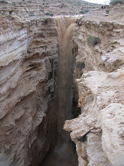
河川の氾濫は、多くの場合、大雨によって引き起こされ、時には雪解け水によってさらに悪化する。ほとんど、あるいは全く前触れなく急速に水位が上昇する洪水は、鉄砲水と呼ばれる。鉄砲水は通常、比較的狭い範囲に集中した豪雨、あるいはその地域が既に以前の降雨によって飽和状態にあった場合に発生する。
自然降水や制御された、あるいは制御されていない貯水池からの放水によって排水路に到達する水の量、場所、タイミングによって、下流地点での流量が決まります。降水の一部は蒸発し、一部は土壌をゆっくりと浸透し、一部は一時的に雪や氷として隔離され、一部は岩、舗装、屋根、飽和または凍結した地面などの表面から急速に流出する可能性があります。降水のうち、排水路にすぐに到達する割合は、乾燥した平地での小雨の場合はゼロから、積雪上の暖かい雨の場合は最大170パーセントまで観測されています。[ 26 ]
ほとんどの降水記録は、一定の時間間隔内に観測された水の深さの測定値に基づいています。関心のある降水閾値の頻度は、観測が可能な全期間内でその閾値を超える測定値の数から決定できます。個々のデータポイントは、各測定深度を観測間の時間間隔で割ることによって強度に変換されます。降雨イベントの継続時間が測定値が報告される一定の時間間隔よりも短い場合、この強度は実際のピーク強度よりも小さくなります。対流性降水イベント(雷雨)は、地形性降水よりも継続時間の短い嵐イベントを引き起こす傾向があります。降雨イベントの継続時間、強度、および頻度は、洪水予測にとって重要です。短時間の降水は、小さな流域内の洪水にとってより重要です。[ 27 ]
洪水規模を決定する上で最も重要な上流側の要因は、対象地域の上流にある流域の土地面積です。降雨強度は、約30 平方マイルまたは 80 平方キロメートル未満の流域では 2 番目に重要な要因です。主要河川の勾配は、より大きな流域では 2 番目に重要な要因です。河川勾配と降雨強度は、それぞれ小規模流域と大規模流域で 3 番目に重要な要因になります。[ 28 ]
集中時間とは、上流の排水区域の最も遠い地点からの流出水が、対象区域の洪水を制御する排水路の地点に到達するのに必要な時間のことです。集中時間は、対象区域におけるピーク降雨の臨界継続時間を定義します。[ 29 ]屋根や駐車場の排水構造物の場合、激しい降雨の臨界継続時間はわずか数分かもしれませんが、河川流域の場合は数日間の累積降雨が臨界となります。
下り坂を流れる水は最終的に下流の状況に遭遇し、流れが遅くなります。沿岸の洪水地帯における最終的な制限は、多くの場合、海または自然の湖を形成する沿岸の洪水砂州です。洪水の低地では、潮汐変動などの標高の変化が沿岸および河口の洪水の重要な決定要因となります。津波や高潮などの予測しにくい事象も、大きな水域の標高の変化を引き起こす可能性があります。流れる水の高さは、流路の形状、特に流路の深さ、流速、および流路内の堆積物の量によって制御されます[ 28 ]。橋や峡谷などの流路の制限は、制限より上の水位を制御する傾向があります。排水路の特定の区間の実際の制御点は、水位の変化に伴って変化する可能性があり、より遠い点がより高い水位を制御するまで、より近い点が低い水位を制御する可能性があります。
洪水流路の有効形状は、植生の発達、氷や瓦礫の堆積、あるいは洪水流路内における橋梁、建物、堤防の建設によって変化する可能性がある。
多くの河川では周期的に洪水が発生し、その周辺地域は氾濫原と呼ばれる。降雨量が比較的少ない場合でも、ハリケーンなどの強風によって湖や湾の岸辺が浸水することがある。

極端な洪水は、異常に激しい暖かい降雨によって大量の積雪が溶け、流氷によって水路が塞がれ、ビーバーダムのような小さな貯水池が解放されるなど、偶然の出来事によって発生することが多い。[ 33 ]偶然の出来事によって、障害物のない排水路内を流れる降雨流出のみを考慮した単純な統計的予測モデルから予想されるよりも、広範囲にわたる洪水が頻繁に発生する可能性がある。 [ 34 ]大量の流れが根こそぎになった木質の植生や、ボートや鉄道設備を含む洪水で損傷した構造物や車両を移動させると、堆積物による水路形状の変更がよく発生する。2010 ~2011年のクイーンズランド洪水時の最近の現地測定では、流速、水深、または比運動量のみに基づく基準では、流速と水深の変動によって引き起こされる危険を考慮できないことが示された。[ 35 ]これらの考慮事項は、流れの動きによって巻き込まれる大きな堆積物に関連するリスクをさらに無視している。[ 36 ]

Floods can be a huge destructive power. When water flows, it has the ability to demolish all kinds of buildings and objects, such as bridges, structures, houses, trees, and cars. Economical, social and natural environmental damages are common factors that are impacted by flooding events and the impacts that flooding has on these areas can be catastrophic.[37]There is an interconnectedness between floods and agriculture, climate, economy, and disease (FACED).[38] Floods resulted in losses exceeding USD 1.5 trillion to agriculture between 1991 and 2023, representing the single most destructive hazard type for global agriculture and reflecting the widespread vulnerability of agricultural systems to water-related disasters.[39]

There have been numerous flood incidents around the world which have caused devastating damage to infrastructure, the natural environment and human life.[37]
Floods can have devastating impacts to human societies. Flooding events worldwide are increasing in frequency and severity, leading to increasing costs to societies.[37]
Catastrophic riverine flooding can result from major infrastructure failures, often the collapse of a dam. It can also be caused by drainage channel modification from a landslide, earthquake or volcanic eruption. Examples include outburst floods and lahars. Tsunamis can cause catastrophic coastal flooding, most commonly resulting from undersea earthquakes.
The primary effects of flooding include loss of life and damage to buildings and other structures, including bridges, sewerage systems, roadways, and canals. The economic impacts caused by flooding can be severe.[9]
Every year flooding causes countries billions of dollars' worth of damage that threatens the livelihood of individuals.[40] As a result, there is also significant socio-economic threats to vulnerable populations around the world from flooding.[40] For example, in Bangladesh in 2007, a flood was responsible for the destruction of more than one million houses. And yearly in the United States, floods cause over $7 billion in damage.[41]
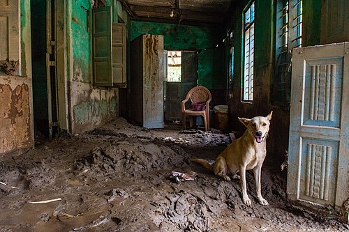
Flood waters typically inundate farm land, making the land unworkable and preventing crops from being planted or harvested, which can lead to shortages of food both for humans and farm animals. Entire harvests for a country can be lost in extreme flood circumstances. Some tree species may not survive prolonged flooding of their root systems.[42]
Flooding in areas where people live also has significant economic implications for affected neighborhoods. In the United States, industry experts estimate that wet basements can lower property values by 10–25 percent and are cited among the top reasons for not purchasing a home.[43] According to the U.S. Federal Emergency Management Agency (FEMA), almost 40 percent of small businesses never reopen their doors following a flooding disaster.[44] In the United States, insurance is available against flood damage to both homes and businesses.[45]
Economic hardship due to a temporary decline in tourism, rebuilding costs, or food shortages leading to price increases is a common after-effect of severe flooding. The impact on those affected may cause psychological damage to those affected, in particular where deaths, serious injuries and loss of property occur.


Fatalities connected directly to floods are usually caused by drowning; the waters in a flood are very deep and have strong currents.[46]Deaths do not just occur from drowning, deaths are connected with dehydration, heat stroke, heart attack and any other illness that needs medical supplies that cannot be delivered.[46]
洪水が発生すると、負傷により罹患率が非常に高くなることがあります。負傷は、洪水に直接巻き込まれた人だけでなく、救助隊や物資を運ぶ人にも影響します。負傷は、洪水の前、最中、後にも発生する可能性があります。[ 46 ]洪水中は、落下する瓦礫や水中の多くの高速で移動する物体によって事故が発生します。洪水後の救助活動では、多数の負傷者が発生する可能性があります。[ 46 ]
水によって運ばれる多くの病原体や細菌のために、伝染病が増加します。コレラ、A型肝炎、E型肝炎、下痢性疾患など、水系感染症は数多くあります。洪水時には清潔な水が不足するため、胃腸疾患や下痢性疾患が非常に多く発生します。洪水が発生すると、清潔な水の供給源が汚染されることがよくあります。A型肝炎とE型肝炎は、洪水の場所や地域社会の洪水への備えの程度にもよりますが、水や住居の衛生状態の悪さのために多く発生します。[ 46 ]
洪水が発生すると、人々は作物、家畜、食料備蓄のほぼすべてを失い、飢餓に直面する可能性があります。[ 47 ]
洪水は送電設備、時には発電設備にも被害を与えることが多く、停電によって連鎖的な影響が生じます。これには、飲料水処理施設や給水設備の停止が含まれ、飲料水の供給停止や深刻な水質汚染につながる可能性があります。また、下水処理施設の停止も引き起こす可能性があります。洪水によって清潔な水が不足し、人間の下水が混入すると、水系感染症のリスクが高まります。洪水の場所によっては、腸チフス、ジアルジア症、クリプトスポリジウム症、コレラなど、さまざまな病気が発生する可能性があります。
道路や交通インフラの損傷により、被災者への支援物資の輸送や緊急医療の提供が困難になる可能性がある。
洪水は家屋を慢性的に湿った状態にし、室内のカビの発生につながり、特に呼吸器症状などの健康被害を引き起こす可能性があります。[ 48 ] 災害発生後には呼吸器疾患がよく見られます。これは、災害後に発生する水害とカビの量によって異なります。研究によると、沿岸部や湿地帯に住む人々では、湿気とカビへの曝露による呼吸器系の健康被害が30~50%増加するとされています。家の中の真菌汚染は、アレルギー性鼻炎や喘息の増加と関連しています。[ 49 ]洪水が収まった後に残る静止水のために、媒介生物媒介性疾患も増加します。媒介生物媒介性疾患には、マラリア、デング熱、ウエストナイル熱、黄熱病などがあります。[ 46 ]洪水は、被災者の心理社会的健全性に大きな影響を与える可能性があります。人々はさまざまな損失とストレスに苦しんでいます。長期的な健康問題の中で最も多く治療されている病気の一つは、洪水とそれに伴うあらゆる悲劇によって引き起こされるうつ病である。[ 46 ]
以下は、世界で最も被害の大きかった洪水の一覧です。死者数が10万人以上の洪水事例を示しています。
洪水(特に頻繁に発生する洪水や小規模な洪水)は、地下水の涵養、土壌の肥沃化、土壌中の栄養分の増加など、多くの恩恵をもたらすこともあります。そのため、周期的な洪水は、ティグリス・ユーフラテス川、ナイル川、インダス川、ガンジス川、黄河など沿岸に暮らしていた古代の人々の生活にとって不可欠なものでした。
洪水は、年間を通して降水量が非常に不均一に分布する乾燥地域や半乾燥地域で、非常に必要な水資源を提供し、農地の害虫を駆除します。淡水の洪水は特に、河川回廊の生態系を維持する上で重要な役割を果たし、氾濫原の生物多様性を維持する上で重要な要素となっています。[ 51 ]洪水は栄養分を湖や河川に拡散させ、数年間は生物量の増加や漁業の改善につながる可能性があります。
一部の魚種にとって、浸水した氾濫原は、捕食者が少なく、栄養分や餌が豊富なため、産卵に非常に適した場所となる可能性がある。 [ 52 ]ウェザーフィッシュなどの魚は、洪水を利用して新しい生息地に到達する。鳥類の個体群も、洪水によって引き起こされる食料生産の増加から恩恵を受ける可能性がある。[ 53 ]
再生可能エネルギー源である水力発電の実現可能性は、洪水が発生しやすい地域においてより高い。
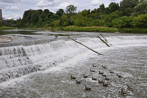
洪水管理または洪水制御とは、洪水による悪影響を軽減または防止するために用いられる手法です。洪水は、上流での異常気象などの自然現象と、水域や流出水に対する人為的な変化の両方によって引き起こされる可能性があります。洪水管理手法には、構造的手法(すなわち洪水制御)と非構造的手法があります。構造的手法は洪水を物理的にせき止めるのに対し、非構造的手法はそうではありません。洪水防止壁などの硬質インフラを構築することは、洪水管理に効果的です。しかし、景観工学においては、水量の増加に対応するために、湿地や氾濫原などの軟質インフラや自然システムに頼ることが最善策とされています。
洪水管理には、洪水災害に対するリスク、脆弱性、暴露を軽減するための対策に焦点を当て、例えば洪水リスク評価を通じてリスク分析を提供する洪水リスク管理が含まれる。[ 54 ]洪水緩和は、洪水リスクと潜在的な影響を軽減し、洪水事象に対する回復力を向上させるために講じられるより広範な戦略を説明する、関連するが別の概念である。
気候変動により洪水リスクと洪水の強度が増大しているため、洪水管理は気候変動への適応と気候変動への回復力の重要な部分です。[ 55 ] [ 56 ]例えば、沿岸洪水を防止または管理するために、沿岸管理の実践では、潮汐などの自然プロセスだけでなく、気候変動による海面上昇にも対処する必要があります。洪水の防止と軽減は、個々の物件、小規模コミュニティ、町や都市全体の3つのレベルで研究できます。
世界中の多くの国では、洪水が発生しやすい水路はしばしば慎重に管理されています。貯水池、堤防、[ 57 ]堤防、貯水池、堰などの防御施設が、水路が堤防を越えて氾濫するのを防ぐために使用されています。これらの防御施設が機能しなくなった場合、土嚢や持ち運び可能な膨張式チューブなどの緊急対策が、洪水を食い止めるためによく使用されます。ヨーロッパやアメリカ大陸の一部では、海岸の洪水は、防潮堤、砂浜の養浜、バリアー島などの海岸防御施設によって対処されています。
河川や小川の河畔域では、長期間にわたって多くの水路が蛇行する原因となる自然の力を抑制または逆転させるために、侵食防止対策を講じることができます。また、洪水の発生頻度と深刻度を軽減するために、ダムなどの治水施設を建設し、長期にわたって維持管理することも可能です。米国では、米陸軍工兵隊がこうした治水ダムのネットワークを管理しています。
都市部の洪水が発生しやすい地域では、人工の下水道システムや雨水排水インフラの修復・拡張が解決策の一つとなります。また、自然排水路、透水性舗装、湿地(これらを総称してグリーンインフラまたは持続可能な都市排水システム(SUDS)と呼びます)などを活用して、道路、駐車場、建物の不浸透性表面を減らすことも有効な対策です。洪水が発生しやすい地域は、一時的な浸水に耐えられる公園や遊び場に転換することも可能です。開発業者に敷地内での雨水貯留を義務付けたり、建物を高床式にしたり、防潮壁や堤防で保護したり、一時的な浸水に耐えられる設計にするよう求める条例を制定することもできます。さらに、所有者自身も、建物から水の流れを遠ざけるために敷地の景観を整備したり、雨水タンク、排水ポンプ、逆止弁を設置したりするなど、対策に投資することができます。


米国では、国立気象局が洪水に対して「引き返せ、溺れるな」というアドバイスを出しています。つまり、洪水地帯を渡ろうとするのではなく、そこから避難することを推奨しています。最も基本的なレベルでは、洪水に対する最善の防御策は、洪水危険区域に居住することによる予見可能なリスクと利点のバランスを取りながら、価値の高い用途のために高台を探すことです。[ 58 ]: 22-23病院、緊急オペレーションセンター、警察、消防、救助サービスなどの重要なコミュニティ安全施設は、洪水のリスクが最も低い地域に建設されるべきです。橋などの構造物は、洪水危険区域にどうしても設置しなければならないため、洪水に耐えられるように設計する必要があります。洪水のリスクが最も高い地域は、洪水が差し迫っているときに人々がより安全な場所に避難する際に一時的に放棄できる価値の高い用途に利用することができます。
洪水対策の計画には、以下のような多くの分析と工学的側面が含まれます。
それぞれのテーマは、時間、空間、関係者の範囲と規模が異なるものの、関連性のある異なる問題を提起する。氾濫原で作用するメカニズムを理解し、管理しようとする試みは、少なくとも6千年にわたって行われてきた。[ 59 ]
米国では、州洪水管理協会が、洪水によって引き起こされる現在および将来の損失、費用、および人々の苦しみを軽減し、洪水氾濫原の自然で有益な機能を保護するための教育、政策、および活動を推進しており、これらすべては悪影響を引き起こすことなく行われています。[ 60 ]米国における災害軽減のベストプラクティスの事例集は、連邦緊急事態管理庁から入手できます。 [ 61 ]
洪水後の清掃活動は、作業員やボランティアに危険をもたらすことが多い。潜在的な危険には、電気的危険、一酸化炭素への曝露、筋骨格系の危険、熱中症や寒冷ストレス、自動車関連の危険、火災、溺水、有害物質への曝露などがある。浸水した災害現場は不安定なため、清掃作業員は、鋭利な破片、洪水中の生物学的危険物、露出した電線、血液やその他の体液、動物や人間の遺体などに遭遇する可能性がある。洪水災害の計画と対応において、管理者は作業員にヘルメット、ゴーグル、厚手の作業用手袋、ライフジャケット、スチール製のつま先とインソールを備えた防水ブーツを提供する。[ 62 ]
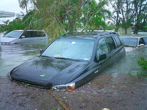
河川区間における年間最大流量の系列を統計的に分析することで、その区間における100年洪水やその他の再現期間の洪水を推定することができる。水文学的に類似した地域内の多くの地点から得られた同様の推定値を、各流域の測定可能な特性と関連付けることで、直接分析に十分なデータがない河川区間についても、洪水の再現期間を間接的に推定することが可能となる。
Physical process models of channel reaches are generally well understood and will calculate the depth and area of inundation for given channel conditions and a specified flow rate, such as for use in floodplain mapping and flood insurance. Conversely, given the observed inundation area of a recent flood and the channel conditions, a model can calculate the flow rate. Applied to various potential channel configurations and flow rates, a reach model can contribute to selecting an optimum design for a modified channel. Various reach models are available as of 2015, either 1D models (flood levels measured in the channel) or 2D models (variable flood depths measured across the extent of a floodplain). HEC-RAS,[63] the Hydraulic Engineering Center model, is among the most popular software, if only because it is available free of charge. Other models such as TUFLOW[64] combine 1D and 2D components to derive flood depths across both river channels and the entire floodplain.
Physical process models of complete drainage basins are even more complex. Although many processes are well understood at a point or for a small area, others are poorly understood at all scales, and process interactions under normal or extreme climatic conditions may be unknown. Basin models typically combine land-surface process components (to estimate how much rainfall or snowmelt reaches a channel) with a series of reach models. For example, a basin model can calculate the runoff hydrograph that might result from a 100-year storm, although the recurrence interval of a storm is rarely equal to that of the associated flood. Basin models are commonly used in flood forecasting and warning, as well as in analysis of the effects of land use change and climate change.
米国では、リアルタイムの水文コンピューターモデリングへの統合的アプローチでは、米国地質調査所(USGS) [ 65 ] 、さまざまな協力観測ネットワーク[ 66 ]、さまざまな自動気象センサー、NOAA国立運用水文リモートセンシングセンター (NOHRSC) [ 67 ] 、さまざまな水力発電会社などからの観測データと、予想される降雨量および/または融雪量の定量的降水予測(QPF)を組み合わせて、日次または必要に応じて水文予測を生成します。[ 68 ] NWS はまた、セントローレンス水路の地域のように、米国とカナダの両方に影響を与える水文予測について、カナダ環境省と協力しています。
世界中の洪水状況を地図化するコンピュータツールであるグローバル洪水監視システム「GFMS」はオンラインで利用可能です。[ 69 ]世界中のユーザーはGFMSを使用して、自分の地域で洪水が発生する可能性がある時期を判断できます。GFMSは、NASAの地球観測衛星と全球降水観測衛星「GPM」からの降水データを使用します。GPMからの降雨データは、植生被覆、土壌の種類、地形を取り入れた地表面モデルと組み合わせて、地面にどれだけの水が浸透しているか、どれだけの水が河川流量に流れ込んでいるかを判断します。
ユーザーは、世界地図上の12キロメートルごとのグリッドポイントごとに、3時間ごとの降雨量、河川流量、水深、洪水に関する統計情報を確認できます。これらのパラメータの予測は5日先までです。ユーザーはズームインして、浸水マップ(水に覆われると推定されるエリア)を1キロメートルの解像度で表示できます。[ 70 ]
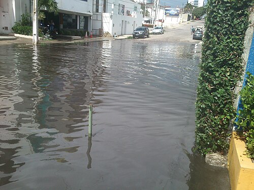
洪水が発生する前に予測することで、予防措置を講じたり、人々に警告したりすることが可能になり[ 71 ]、洪水状況に事前に備えることができます。たとえば、農家は家畜を低地から避難させることができ、公共サービス事業者は必要に応じてサービスを迂回するための緊急措置を講じることができます。緊急サービス事業者は、緊急事態が発生したときに対応できるよう、事前に十分な資源を確保しておくこともできます。人々は浸水する地域から避難することができます。
In order to make the most accurate flood forecasts for waterways, it is best to have a long time-series of historical data that relates stream flows to measured past rainfall events.[72] Coupling this historical information with real-time knowledge about volumetric capacity in catchment areas, such as spare capacity in reservoirs, ground-water levels, and the degree of saturation of area aquifers is also needed in order to make the most accurate flood forecasts.
Radar estimates of rainfall and general weather forecasting techniques are also important components of good flood forecasting. In areas where good quality data is available, the intensity and height of a flood can be predicted with fairly good accuracy and plenty of lead time. The output of a flood forecast is typically a maximum expected water level and the likely time of its arrival at key locations along a waterway,[68] and it also may allow for the computation of the likely statistical return period of a flood. In many developed countries, urban areas at risk of flooding are protected against a 100-year flood – that is a flood that has a probability of around 63% (i.e. 1 − 0.99100, or roughly 1 − 1/e) of occurring in any 100-year period of time.
According to the U.S. National Weather Service (NWS) Northeast River Forecast Center (RFC) in Taunton, Massachusetts, a rule of thumb for flood forecasting in urban areas is that it takes at least 1 inch (25 mm) of rainfall in around an hour's time in order to start significant ponding of water on impermeable surfaces. Many NWS RFCs routinely issue Flash Flood Guidance and Headwater Guidance, which indicate the general amount of rainfall that would need to fall in a short period of time in order to cause flash flooding or flooding on larger water basins.[73]
Flood risks can be defined as the risk that floods pose to individuals, property and the natural landscape based on specific hazards and vulnerability. The extent of flood risks can impact the types of mitigation strategies required and implemented.[74]
世界の人口の大部分は主要な海岸線の近くに住んでおり、[ 8 ]多くの主要都市や農業地域は氾濫原の近くに位置している。[ 9 ]気候変動により、沿岸洪水や河川洪水が増加する重大なリスクがある。[ 10 ]


洪水神話または大洪水神話とは、通常は一つまたは複数の神々によってもたらされる大洪水が、典型的には神の報復として文明を破壊する物語である。これらの神話の洪水は、特定の創造神話に登場する原始の宇宙の海と類似点が指摘されることが多い。なぜなら、洪水は、例えば再生の準備として、社会の浄化や人類の堕落の浄化の手段として説明されているからである。ほとんどの洪水神話には、「生命への人間の渇望を象徴する」文化の英雄も登場する。[ 75 ]
神によって引き起こされた洪水に関する最も古い既知の物語は、メソポタミアのシュメール文化に由来し、紀元前18世紀に遡るアッカド語の叙事詩『アトラ・ハシス』などに表現されている。同様の洪水物語は、聖書の創世記の洪水物語、ヒンドゥー教のマンヴァンタラ・サンディヤ、ギリシャ神話のデウカリオン、北米先住民文化など、他の多くの文化にも見られる。
「flood」という単語は、ゲルマン語派に共通する古英語のflōdに由来します(ドイツ語のFlut、オランダ語のvloed はflow、floatと同じ語根から来ています。また、ラテン語のfluctus、flumenと比較してください)。意味は「水の流れ、潮汐、水による土地の氾濫、大洪水、ノアの洪水、水の塊、川、海、波」です。[ 76 ] [ 77 ]古英語のflōd は、ゲルマン祖語のfloduzに由来します(古フリジア語のflod、古ノルド語のfloð、中期オランダ語の vloet 、オランダ語のvloed、ドイツ語のFlut、ゴート語のflodusはfloduzに由来します)。[ 76 ]
 この記事は、無料コンテンツ作品からのテキストを組み込んでいます。CC BY 4.0ライセンス(ライセンスステートメント/許可)に基づき使用許諾されています。テキストは、国際連合食糧農業機関(FAO)発行の「災害が農業と食料安全保障に及ぼす影響 2025」から引用されています。