
Loading article…
グレーターロンドン
ロンドン (地域) | |
|---|---|
 | |
_(ceremonial_county)_in_England.svg/500px-Greater_London_(zoom)_(ceremonial_county)_in_England.svg.png) | |
| 主権国家 | イギリス |
| 構成国 | イングランド |
| 設立 | 1965年4月1日 |
| 設立者 | 1963年ロンドン政府法 |
| タイムゾーン | UTC+0 (グリニッジ標準時) |
| • 夏 ( DST ) | UTC+1 (イギリス標準時間) |
| 英国議会 | 国会議員73名 |
| 警察 | |
| 儀式郡 | |
| 総督 | ケン・オリサ |
| ハイシェリフ | イナ・デ |
| エリア | 1,569 km 2 (606 平方マイル) |
| • ランク | 48位中37位 |
| 人口 (2022年)[1] | 8,855,333 |
| • ランク | 48 件中 1 件目 |
| 密度 | 5,643/km 2 (14,620/平方マイル) |
| 民族 (2021年)[2] | |
| 地域 | |
| 政府 | グレーター・ロンドン・オーソリティー • サディク・カーン市長 •ロンドン議会 |
| 管理本部 | ニューハム市役所 |
| エリア | 1,572 km 2 (607 平方マイル) |
| 人口 (2022年)[3] | 8,866,180 |
| 密度 | 5,640/km 2 (14,600/平方マイル) |
| GSSコード |
|
| インド | TLI |
| Webサイト | ロンドン |
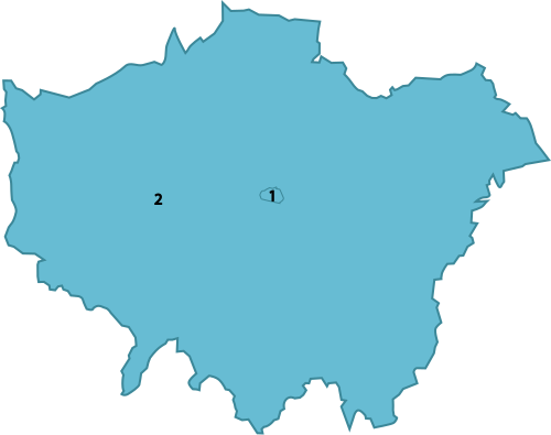 ロンドン地域の儀式郡 | |
| 郡 |
|
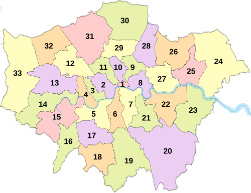 ロンドン市と32のロンドン特別区 | |
グレーター・ロンドンはイングランドの行政区域[4]で、ロンドン地域と境界を接し、ロンドンの連続した市街地のほとんどを占めている。33の地方自治体区域から成り、32のロンドン特別区(グレーター・ロンドンとも呼ばれる儀礼上の郡を形成する)とシティ・オブ・ロンドンがある。グレーター・ロンドン庁は地域全体の戦略的な地方自治に責任を負っており、通常の地方自治は特別区議会とシティ・オブ・ロンドン・コーポレーションが責任を負っている。グレーター・ロンドンは、北はハートフォードシャー、北東はエセックス、南東はケント、南はサリー、西はバークシャーおよびバッキンガムシャーの各儀礼上の郡に接している。
グレーター・ロンドンの面積は1,572 km 2 (607 sq mi)で、2022年の推定人口は8,866,180人です。[3]儀礼上のグレーター・ロンドン州はわずかに小さく、面積は1,569 km 2 (606 sq mi)で、2022年の人口は8,855,333人です。[5]この地域はほぼ完全に都市化されており、グレーター・ロンドン市街地の大部分を占めています。グレーター・ロンドン市街地はハートフォードシャー、エセックス、ケント、サリー、バークシャーまで広がり、2011年の人口は9,787,426人でした。行政区域、地域、儀礼上の州のいずれも市の地位を有していませんが、シティ・オブ・ロンドンとシティ・オブ・ウェストミンスターは別々に市の地位を有しています。この地域は歴史的にミドルセックス、エセックス、サリー、ケント、ハートフォードシャー の一部でした。
テムズ川はこの地域の地理的特徴を決定づける川で、西はハンプトン付近から流れ込み、東に流れてダゲナムの下流に流れ出ます。テムズ川の支流が数本この地域を流れていますが、現在はほとんどが暗渠化されており、ロンドンの下水道システムの一部となっています。川のすぐ北と南の土地は平坦ですが、遠くに行くにつれて低い丘陵、特にハムステッド・ヒース、シューターズ・ヒル、シドナム・ヒルへと高くなっています。この地域の最高地点はノース・ダウンズの一部であるウェスターハム・ハイツ(標高245メートル)です。この地域の北東部には古代の森林地帯であるエッピング・フォレストの一部があります。
シティ・オブ・ロンドンはアングロサクソン時代から独自の政府を持っていた。ロンドン全域で直接選出された最初の地方政府は、1889年に都市圏の中心部を管轄するロンドン州のために設立されたロンドン州議会であった。1965年に州は廃止され、グレーター・ロンドンに置き換えられた。グレーター・ロンドンは、グレーター・ロンドン・カウンシル、32のロンドン特別区、シティ・オブ・ロンドン・コーポレーションによって統治される2層行政区であった。[6]グレーター・ロンドン・カウンシルは1986年に廃止され、その責任は主に特別区に引き継がれた。グレーター・ロンドン庁は2000年に設立された。
行政の歴史
「グレーター・ロンドン」という用語は、1965年に法律で定められる前から使用されていた。この用語は、ロンドン警視庁管区、ロンドン水道局の管轄地域、ロンドン旅客輸送地域、および総務長官が「グレーター・ロンドン都市圏」と定義した地域を指していた。 [7] [8] [9]この用語は、1913年から1916年にかけて考案されたグレーター・ロンドン幹線道路計画や、1927年に考案され面積1,856平方マイル(4,810 km 2 )を占め900万人が住むグレーター・ロンドン計画地域にも使用された。[10] [8]
ロンドン州拡大の提案

ロンドン州議会(LCC)とロンドン州は1889年に設立されたが、その区域はロンドン全体をカバーしていなかった。ロンドンの市街地、郵便区、交通網、ロンドン警視庁管区は、新しい行政区の境界をはるかに超えて広がっていた。広大なベコントリー・エステーツを含むLCCの住宅プロジェクトの多くも、その境界外にあった。[11] LCCは、第一次世界大戦の終結後すぐに、メトロポリタン警察管区とシティ警察管区内に122の住宅当局があることを指摘し、その境界の変更を強く求めた。この問題を検討するために、ロンドン政府に関する王立委員会が設置された。[12] [13] LCCは、ロンドン警視庁管区とホーム・カウンティの間を境界とする、広大な新しいグレーター・ロンドン地域を提案した。[14]ウィンザー、スラウ、イートンを当局に含める可能性に対して抗議が行われた。 [15]委員会は1923年に報告書を作成し、LCCの計画を却下した。 2つの少数派報告書は、小規模な市街地地区の合併にとどまらず、小規模な自治区議会と戦略的機能のための中央当局の両方を含む改革を支持した。1924年ロンドン交通法は、この委員会の成果であった。[16]ロンドン州とその近郊の地方自治体の改革は、次にサー・エドウィン・ハーバートが議長を務めたグレーター・ロンドン地方自治に関する王立委員会によって検討され、 3年間の作業を経て1960年に「ハーバート報告書」を発表した。委員会は、コミュニティがグレーター・ロンドンの一部となるべきかどうかを判断するために、3つのテストを適用した。そのテストとは、その地域がそれ自体で独立した中心としてどれほど強いか、ロンドンとの結びつきがどれほど強いか、そしてその地域がロンドンに向かうのではなく、田舎に向かってどれほど強く引き寄せられているかである。
グレーターロンドンが誕生

グレーター・ロンドンは、 1963年ロンドン行政法によって創設された。同法は1965年4月1日に施行され、ロンドン州議会の権限が限定されていたシティ・オブ・ロンドンを含むミドルセックスとロンドンの行政州に取って代わり、エセックス、ハートフォードシャー、ケント、サリーの一部を吸収した。グレーター・ロンドンはもともと2層の地方自治制度を採用しており、グレーター・ロンドン・カウンシル(GLC)がシティ・オブ・ロンドン・コーポレーション(小規模なロンドン市を統治)および32のロンドン特別区議会と権限を共有していた。GLCは1986年に1985年地方自治法によって廃止された。その機能はシティ・コーポレーションとロンドン特別区に委譲され、一部の機能は中央政府と合同委員会に移管された。[17]グレーター・ロンドンは1994年に ロンドン地域を形成した。
グレーター・ロンドン・オーソリティー
.png/500px-Logo_of_the_Greater_London_Authority_(monochrome).png)
1998年のロンドン住民投票により、地域をカバーする上位レベルの政府を再創設するという国民の意思が確立された。グレーター・ロンドン・オーソリティー、ロンドン議会、および直接選出のロンドン市長は、 1999年グレーター・ロンドン・オーソリティー法により2000年に創設された。2000年、ロンドン警視庁管区の外側の境界線がグレーター・ロンドンの境界線に再調整された。2000年と2004年の市長選挙は、GLCの最後のリーダーであったケン・リビングストンが勝利した。2008年と2012年の選挙はボリス・ジョンソンが勝利した。2016年、2021年、2024年の選挙はサディク・カーンが勝利した。Brexit以前は、ロンドンは欧州議会の単一選挙区によってカバーされていた。
地理


グレーター・ロンドンには、グレーター・ロンドン都市圏の最も密接に関連した部分とその歴史的緩衝地帯が含まれ、5つの行政区にまたがるメトロポリタン・グリーンベルトの重要な部分も含まれ、この都市の公園と同様の方法で指定された緑地を保護している。最も近い境界と最も遠い境界[要説明]は、北東のエッピング・フォレストに隣接するスワードストーンベリーとチンフォードの間のエセックスと、ブルファンとノース・オッケンドンの間のマー・ダイクである。グレーター・ロンドンはまた、北はハートフォードシャー、西はバークシャーとバッキンガムシャー、南東はケント、南と南西はサリーと接している。最高地点はノース・ダウンズにありケントとの境界にあるウェスターハム・ハイツで、標高は245メートル(804フィート)である。[18]中央政府は小規模な境界変更 を実施している。最大のものは1969年にファーレイをサリーに、ノックホルトをケントに移管したことである。[19]他には、テムズ川の2つの島をサリー州と交換したり、1990年代にM25付近の3つの自治区の境界の一部を調整したりした。[20]グレーター・ロンドンのうち高速道路の外側にあるのは、中心部から最も遠いノース・オッケンドンのみである。グレーター・ロンドンの大部分は、ロンドン低排出ゾーン(LEZ)と超低排出ゾーン(ULEZ)となっている。
ロンドン郵便区はグレーターロンドン全体をカバーしているわけではない。[21] [22] [23]
ガバナンス
グレーター・ロンドン・オーソリティー
グレーター・ロンドンは、グレーター・ロンドン・オーソリティー(GLA)の戦略的地方統治下にあります。[24] グレーター・ロンドン・オーソリティーは、選挙で選ばれた議会であるロンドン議会と、行政の長であるロンドン市長で構成されています。[25]
現在の市長(ロンドン市長と混同しないように)はサディク・カーンである。彼は選出されたロンドン議会によって精査されており、議会は彼の年間予算を修正することができる(3分の2の多数決で)が、それ以外では彼の指示を阻止する権限はない。GLAの本部は以前はサザークのシティホールにあったが、 2022年1月にニューハムのザ・クリスタルに移転した。 [26]市長はグレーター・ロンドンの戦略計画に責任を負っており、選挙サイクルごとにロンドン計画を作成または修正することが求められている。
ロンドン市長
ロンドン市長は直接選出された政治家であり、ロンドン議会とともにグレーター・ロンドンの戦略的な政府に責任を負っています。
ロンドン議会
ロンドン議会選挙では、ロンドンは 14 の選挙区に分割され、各選挙区は 2 つまたは 3 つの自治区から構成されます。シティ・オブ・ロンドンはシティ・アンド・イースト選挙区の一部です。
英国議会
ロンドンは 73 の議会区選挙区に分かれており、 1 つ以上の自治区の複数の区を合わせた地域から構成されています。通常、自治区は2 つまたは 3 つの選挙区によってカバーされます。
状態
ロンドン地域は、国王から都市としての地位を与えられていない。その中のロンドン市とウェストミンスター市は、正式な都市としての地位を与えられている。 [27] [a]それにもかかわらず、グレーター・ロンドンは、大都市圏や自治体の一般的な意味での都市とみなされている。ロンドン市を除くその地域には、グレーター・ロンドンの知事が任命されている。 1997年知事法の目的上、この地域は郡として定義されている。[28]
「ロンドン」という用語は通常、地域または大都市圏を指し、古代の小さなロンドン市を指すことはあまりありません。[29] [30]その小さな地域は「シティ」または「スクエアマイル」と呼ばれることが多く、主要な金融街を形成しています。 古代、ロンドンの都市化された地域はメトロポリスとして知られていました。 一般的な用法では、「ロンドン」と「グレーターロンドン」という用語は通常、同じ意味で使用されます。[29]グレーターロンドンは、さまざまな定義で、いくつかの目的のためにインナーロンドンとアウターロンドンに正式に分割されています。 いくつかの戦略計画の目的で、5つのサブリージョンに分割されています。
地方自治体
グレーター・ロンドンは32のロンドン特別区に分かれており、それぞれがロンドン特別区議会によって統治されている。シティ・オブ・ロンドンは12世紀に遡る独自の政府を持ち、グレーター・ロンドン州とは別個の存在であるが、グレーター・ロンドン庁の管轄地域の一部となっている。[29]
ロンドンの自治区議会はすべて、ロンドン議会協会に所属しています。ロンドンの自治区のうち、ケンジントン・アンド・チェルシー、キングストン、グリニッジの 3 つはロイヤル・バラという敬称を持っています。シティ・オブ・ロンドン内には、ミドル・テンプルとインナー・テンプルという 2 つの自治区があります。


人口統計

工業化が進むにつれて、ロンドンの人口は19世紀から20世紀初頭にかけて急速に増加し、1925年にニューヨークに追い抜かれるまで世界で最も人口の多い都市でした。人口は1939年に8,615,245人でピークに達しました。2009年半ばの公式居住者は推定7,753,600人でした[要確認] 。 [32] [検証に失敗]
ロンドンの広域都市圏の人口は、その地域の定義に応じて 1,200 万から 1,300 万の間です。ユーロスタットによると、ロンドンは欧州連合で最も人口の多い都市および都市圏です。
この地域は1,579平方キロメートルの面積をカバーしています。人口密度は1平方キロメートルあたり4,761人で、英国の他の地域の10倍以上です。人口で見ると、ロンドンは世界で25番目に大きな都市であり、17番目に大きな大都市圏です。[いつ? ]市内に住む米ドル億万長者の数では世界第4位です。東京やモスクワと並んで、世界で最も物価の高い都市の1つにランクされています。
民族グループ
2001年の英国国勢調査では、人口の71.15%が自らの民族グループを白人と分類しており、これには白人英国人 (59.79%)、白人アイルランド人 (3.07%) または「その他の白人」(8.29%、ほとんどがギリシャ系キプロス人、イタリア人、ポーランド人、ポルトガル人) が含まれます。12.09% は自らを英国アジア人と分類しており、これにはインド人、パキスタン人、バングラデシュ人、「その他のアジア人」(ほとんどがスリランカ人、アラブ人、その他の南アジア民族) が含まれます。10.91% は自らを黒人英国人と分類しています (約 6% が黒人アフリカ人、4% が黒人カリブ人、0.84% が「その他の黒人」)。3.15% は混血、1.12% は中国人、1.58% はその他 (ほとんどがフィリピン人、日本人、韓国人、ベトナム人、その他の「英国東洋人」)アイルランド共和国と北アイルランドの両方に住むアイルランド人の数は約 20 万人で、スコットランド人とウェールズ人を合わせると約 20 万人になります。
2005 年 1 月、ロンドンの民族的および宗教的多様性に関する調査では、300 以上の言語が話されており、人口 10,000 人を超える非先住民コミュニティが 50 以上あると報告されています。英国国家統計局の数字によると、2006 年のロンドンの外国生まれの人口は 2,288,000 人 (31%) で、1997 年の 1,630,000 人から増加しています。2001 年の英国国勢調査では、人口の 27.1% が英国外で生まれており、非白人に分類される割合がわずかに高いことが示されています。
2011年の英国国勢調査では、人口の59.79%が自らの民族グループを白人と分類しており、これには白人英国人 (44.89%)、白人アイルランド人 (2.15%)、または「その他の白人」(12.65%、主にギリシャ系キプロス人、イタリア人、ポーランド人、スペイン人、コロンビア人、ポルトガル人) が含まれます。18.49%は自らを英国アジア人と分類しており、これにはインド人、パキスタン人、バングラデシュ人、「その他のアジア人」(主にスリランカ人、アラブ人、その他の南アジア民族) が含まれます。13.32%は自らを黒人英国人と分類しています (7%が黒人アフリカ人、4.22%が黒人カリブ人、2.08%が「その他の黒人」)。4.96%は混血で、3.44%がその他 (主にフィリピン人、日本人、韓国人、ベトナム人、その他の「英国東洋人」) です。
この表は、2011年に居住者の出生数上位21カ国を示している。[33]これらの数字は、各国に関連する特定の民族グループの総人口を公平に示すものではない。例えば、ギリシャ系(ギリシャとキプロスの両方)のロンドン居住者は30万人だが、これは組織化されたギリシャ人コミュニティがほぼ2世紀前から存在しているためである。何世紀も前からコミュニティが存在するイタリア系とフランス系のロンドン居住者についても同じことが言える(フランス大使館は、英国には30万人から40万人のフランス国民が住んでおり、「その大部分がロンドンに住んでいる」と推定している)。[34]ポーランド人コミュニティは中世後期からロンドンに存在していたが、2001年の国勢調査ではそれほど大きくなかったが、ポーランドが欧州連合に加盟した2004年以降は大幅に増加し、2010年6月までにロンドンのポーランド人居住者は12万2千人に達した。[35]しかし、ドイツ生まれの人口の数字には、ドイツでイギリス軍に勤務する両親から生まれたイギリス国民も含まれているため、誤解を招く可能性がある。
ロンドンは、安全な場所として、あるいは経済的な理由から、何世紀にもわたって移民の中心地となってきました。前者の例としては、ユグノー、東ヨーロッパ系ユダヤ人、キプロス人、東アフリカ系アジア人などが挙げられます。後者の例としては、アイルランド人、バングラデシュ人、西インド諸島人などが挙げられます。スピタルフィールズ周辺のイーストエンド地区は、いくつかの民族グループの最初の故郷であり、その後、繁栄するにつれてロンドンの他の場所に移動しました。
- ^ ab 2011年の国勢調査のために作成された新しいカテゴリ。
- ^ 2021年の国勢調査のために作成された新しいカテゴリ。
- ^ 2001年には「その他の民族」の見出しの下にリストされました。
人口

現在のグレーター・ロンドン地域の人口は、1801年の約110万人(当時は都市部には約85万人しかおらず、25万人はまだロンドンの一部ではなかった村や町に住んでいた)から1939年には推定860万人に増加したが、1988年には670万人に減少し、1990年代に回復し始めた。
2006年までに人口は1970年のレベル(および1920年代の人口レベル)まで回復しました。現在では、1939年のピークを超え、900万人を超えています。
ここでの数字は、2001 年の境界内のグレーター ロンドンの数字です。1971 年以前の数字は、過去の国勢調査に基づいて英国国家統計局が 2001 年の境界に合わせて再構築したものです。1981 年以降の数字は年半ばの推定値 (2007 年 8 月に改訂) であり、ロンドンの人口を過小評価することが知られている国勢調査よりも正確です。
経済
.png/500px-Regional_Profile_of_London_(as_of_2013).png)
これは、英国国家統計局が公表した(240~253ページ)現在の基本価格におけるロンドン中心部の地域総付加価値(GVA)の推移グラフで、数値は百万英国ポンドで示されています。
ユーロスタットのデータによると、2009年のロンドン中心部のGDPは2,320億ユーロ[52]、一人当たりGDPは7万8,000ユーロとなっている。
これは、英国国家統計局が公表した(240~253ページ)現在の基本価格におけるロンドン郊外の地域総付加価値の推移グラフで、数値は百万英国ポンドで示されています。
ユーロスタットのデータによると、2009年のロンドン郊外のGDPは1030億ユーロ[52]、一人当たりGDPは21,460ユーロでした。
宗教

最大の宗教グループは、キリスト教(48.4%)、イスラム教(8.4%)、ヒンズー教(8.0%)、ユダヤ教(1.8%)、シク教(1.5%)、仏教(1.0%)で、無宗教(21.7%)がそれに続く。英国は伝統的にキリスト教国であり、ロンドンには、特に市内に多数の教会がある。シティのセント・ポール大聖堂と川の南にあるサザーク大聖堂は英国国教会の行政中心地であり、一方、イングランド国教会および世界的英国国教会の聖職者であるカンタベリー大主教は、ロンドン特別区ランベスにあるランベス宮殿を主な住居としている。
重要な国家および王室の儀式は、セントポール大聖堂とウェストミンスター寺院で共同で行われます。この寺院は、イングランドとウェールズで最大のローマカトリックの大聖堂である近くのウェストミンスター大聖堂とは別物です。ロンドンの宗教的慣習は、英国や西ヨーロッパの他のどの地域よりも低く、アメリカの平均の約7分の1です。英国国教会の普及にもかかわらず、その宗派内での毎週の儀式は低いですが、近年、特にロンドンの福音派英国国教会の教会への出席が増加し始めています。
London is home to sizeable Hindu, Sikh, Buddhist, Muslim and Jewish communities. Many Muslims live in Tower Hamlets and Newham; the most important Muslim buildings are the East London Mosque in Whitechapel and the London Central Mosque on the edge of Regent's Park. London's large Hindu community is in the north-western boroughs of Harrow and Brent, the latter containing one of Europe's largest Hindu temples, BAPS Shri Swaminarayan Mandir London.
Sikh communities are in East and West London, particularly Southall in the western borough of Ealing, which is also home to the largest Sikh temple in the capital. The majority of British Jews live in London, with significant communities in Stamford Hill (the most Orthodox Jewish area outside New York City and Israel) and St. John's Wood, Golders Green, and Edgware in North London.
Education
Publicly funded education has been administered through 33 LEAs, which correspond to the City of London and the 32 London boroughs, since the 1990 enactment of the Education Reform Act 1988.[53] From 1965 to 1990, 12 Inner London boroughs and the City of London were served by the Inner London Education Authority.[53]
The introduction of comprehensive schools, directed by Circular 10/65 in 1965, was mostly followed in Greater London; however, 19 grammar schools have been retained in some Outer London boroughs,[54] with Sutton having the most with five, followed by Bexley with four and others in five other boroughs. In these boroughs the state schools outperform the (relatively few) independent schools. In inner London, private schools always get the best results and are larger in number. At GCSE and A level, Outer London boroughs have broadly better results than Inner London boroughs.[55]
At GCSE, the best borough is Kingston upon Thames, closely followed by Sutton. Both boroughs have selective schools, and get the top two average GCSE results in England for LEAs. Next is Kensington and Chelsea, the third best in England, then Redbridge, Hammersmith and Fulham, Bromley, Barnet and Harrow. Only ten boroughs have GCSE results under the England average, and some inner-London boroughs have surprisingly good results considering where they lie on the scale of deprivation, e.g. Lambeth. Overall at GCSE in 2009, Greater London had the best results for regions of England. Greater London is generally a prosperous region, and prosperous areas generally have good GCSE results. The City of London has no state schools, just two independent schools. Haringey and Kensington and Chelsea have the most people that pass no GCSEs.[citation needed]
At A-level, the average results for LEAs are disappointing compared to their good GCSE results. Although Kingston upon Thames gets the best GCSE results in England, at A-level it is not even above average. Sutton gets the best A-level results in London and in England. Three of the schools in the top four at A-level in London are in Sutton. It has only one independent school. The few other boroughs with above-average A-level results are Havering, Barnet, Bexley, Redbridge, and Ealing. The poor A-level results in many London boroughs is explained by the quantity of independent schools getting good A-level results. The state school system is often bypassed at age 16 by the more able pupils. Some London boroughs need more good sixth form colleges.[citation needed]
The region's 34 further education colleges are funded through the Skills Funding Agency and the Young People's Learning Agency. Large colleges include Kingston College, Havering College of Further and Higher Education, and Croydon College.
Universities
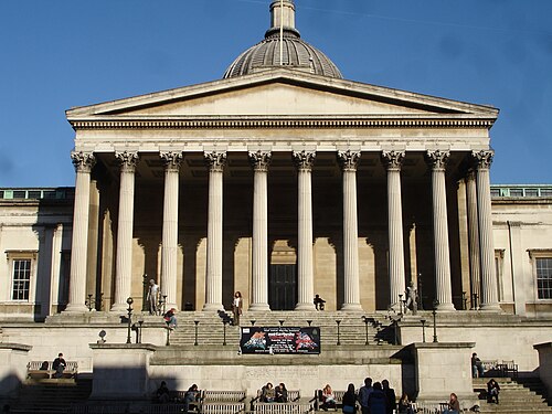
The University of London has 20 federated colleges and schools. The two main constituents of the University of London are (in order of total funding) University College London (UCL) and King's College London (KCL). Imperial College was part of the University of London until 2007, and is now an independent university. UCL, KCL and Imperial have very large research grants – some of the largest in England after Cambridge and Oxford, UCL and Imperial receive around £600 million each which is more than twice as much as any other in the region. The next largest institution by funding is Queen Mary University of London, followed by City, University of London. London is also home to the London School of Economics and Political Science (LSE), one of the few solely social science institutions in the world. Together with UCL and Imperial, they make up the London vertex of the Golden Triangle universities, the other institutions being Oxford and Cambridge. The region has many medical schools although these are part of other institutions such as UCL, KCL and Imperial. The Royal Veterinary College is based in Camden (with another site in North Mymms in Hertfordshire).
50% of students come from the region, and around 30% from other regions. Most students from other regions come from South East England, the East of England, and, to a lesser degree, South West England; the vast majority are from the south of England. Over 50% students native to the region stay in the region, with 15% going to South East England, 30% to either Scotland, Wales or the North East and around 5% go elsewhere. London is a draw for UK graduates from all over the UK.
Over 70% of UK students to graduate from the University of London remain in London; just under 15% go to the South-East, and just over 5% go to the East of England and 10% elsewhere.
Twin cities
The GLA has twin and sister city agreements with the following cities.[56]
See also


.svg/500px-Europe_(orthographic_projection).svg.png)
- Geographical
- Central London
- Inner London
- Outer London
- London boroughs
- Greater London Urban Area
- London commuter belt
- Metropolitan Police District
- M25 motorway
- Political
- Mayor of London
- List of Lord Lieutenants of Greater London
- List of High Sheriffs of Greater London
- London Plan
- City of London
- Historical
- Others
Notes
- ^ Croydon and Southwark have made several failed applications for city status.
- ^ a b Components may not sum to totals due to rounding.
- ^ a b Includes hunting and forestry.
- ^ a b Includes energy and construction.
- ^ a b Includes financial intermediation services indirectly measured.
References
- ^ "Mid-2022 population estimates by Lieutenancy areas (as at 1997) for England and Wales". Office for National Statistics. 24 June 2024. Retrieved 26 June 2024.
- ^ UK Census (2021). "2021 Census Area Profile – London Region (E12000007)". Nomis. Office for National Statistics. Retrieved 1 June 2024.
- ^ a b "Mid-Year Population Estimates, UK, June 2022". Office for National Statistics. 26 March 2024. Retrieved 3 May 2024.
- ^ "London Government Act 1963 - Latest Available". legislation.gov.uk. Archived from the original on 29 October 2021. Retrieved 12 October 2021.
- ^ "Mid-2022 population estimates by Lieutenancy areas (as at 1997) for England and Wales". Office for National Statistics. 24 June 2024. Retrieved 26 June 2024.
- ^ "London Government Act 1963 - Latest Available". legislation.gov.uk. Archived from the original on 29 October 2021. Retrieved 12 October 2021.
- ^ Vision of Britain – Census 1901: Preliminary Report Archived 22 October 2012 at the Wayback Machine
- ^ a b Young, K. & Garside, P., Metropolitan London: Politics and Urban Change, (1982)
- ^ Westergaard, J., The Structure of Greater London, London: Aspects of Change, (1961)
- ^ The Motorway Archive – The origins of the London Orbital Motorway (M25) Archived 20 July 2009 at the Wayback Machine
- ^ Saint, A., Politics and the people of London: the London County Council (1889–1965), (1989)
- ^ London Local Government. The Times. 18 April 1921.
- ^ Complex London: Big Task For Inquiry Commission. The Times. 5 August 1921.
- ^ Greater London: Case for Central Authority: Area and Powers. The Times. 14 December 1921.
- ^ Windsor and Greater London: Protests Against Proposals. The Times. 27 December 1921
- ^ Greater London: Report of Royal Commission. The Times. 22 March 1923.
- ^ 'The Government of London: the struggle for reform' by Gerald Rhodes (London: Weidenfeld and Nicolson 1970 ISBN 0-297-00031-4
- ^ Bathurst, David (2012). Walking the county high points of England. Chichester: Summersdale. pp. 82–85. ISBN 978-1-84-953239-6.
- ^ The Greater London, Kent and Surrey Order, 1968
- ^ The Greater London and Surrey Order, 1970
- ^ Laurence Cawley (5 July 2013). "London Government Act: Essex, Kent, Surrey and Middlesex 50 years on". BBC News. Archived from the original on 20 June 2018. Retrieved 21 June 2018.
- ^ "House of Commons Hansard Debates for 23 Jun 2009 (pt 0008)". Publications.parliament.uk. Archived from the original on 5 August 2017. Retrieved 19 August 2017.
- ^ [1][permanent dead link] Royal Mail (2004)
- ^ Jones, B. et al., Politics UK, (2004)
- ^ Arden Chambers Barristers, A Guide to the Greater London Authority Act, (2000)
- ^ Cox, Michael (30 November 2021). "'London is moving east': City Hall's Crystal move confirmed for New Year". Newham Recorder. Archived from the original on 2 December 2021. Retrieved 2 December 2021.
- ^ Westminster City Council – One City – An Introduction Archived 22 May 2009 at the Wayback Machine
- ^ HMSO, Lieutenancies Act 1997 Archived 30 October 2007 at the Wayback Machine, (1997)
- ^ a b c Travers, T., The Politics of London, (2004)
- ^ Mills, A., Dictionary of London Place Names, (2001), Oxford
- ^ "TS012: Country of birth (detailed)". Office for National Statistics. Retrieved 30 March 2024.
- ^ "2009 Round Demographic Projections for the London Plan" (PDF). 2 April 2013. Archived (PDF) from the original on 2 April 2013. Retrieved 17 January 2020.
- ^ "Greater London Authority – Summary of 'Country-of-Birth' in London" (PDF). Greater London Authority. Archived from the original (PDF) on 27 May 2008. Retrieved 6 June 2008.
- ^ "London, France's sixth biggest city". BBC News. 30 May 2012. Archived from the original on 17 July 2018. Retrieved 21 June 2018.
- ^ "Polish people in the UK". Office for National Statistics. 24 February 2011. Archived from the original on 19 March 2011.
- ^ "2001 census – theme tables". NOMIS. Archived from the original on 20 November 2012. Retrieved 5 September 2014.
- ^ "Ethnic Group by measures". NOMIS. Archived from the original on 3 September 2014. Retrieved 2 September 2014.
- ^ "TS021 - Ethnic group". Nomis: Official Census and Labour Market Statistics. Retrieved 30 March 2023.
- ^ "Home - Office for National Statistics". www.ons.gov.uk. Archived from the original on 19 December 1996. Retrieved 15 July 2020.
- ^ a b "2016 Mid-Year Estimates – London Datastore". Archived from the original on 7 May 2019. Retrieved 7 May 2019.
- ^ "T 08: Quinary age group and sex for local authorities in England and Wales; estimated resident population based on the 1991 Census; Mid-1981 Population Estimates". Office for National Statistics. 22 August 2007. Archived from the original on 11 January 2009. Retrieved 22 August 2007.
- ^ "T 08h: Mid-1988 Population Estimates; Quinary age groups and sex for local authorities in England and Wales; estimated resident population revised in light of results of the 2001 Census". Office for National Statistics. 22 August 2007. Archived from the original on 27 June 2008. Retrieved 22 August 2007.
- ^ "T 09a: Mid-1991 Population Estimates; Quinary age groups and sex for local authorities in the United Kingdom; estimated resident population". Office for National Statistics. 22 August 2007. Archived from the original on 11 January 2009. Retrieved 22 August 2007.
- ^ "T 08: Selected age groups for local authorities in the United Kingdom; estimated resident population; revised in light of the local authority population studies; Mid-2001 Population Estimates". Office for National Statistics. 22 August 2007. Archived from the original on 11 January 2007. Retrieved 22 August 2007.
- ^ "T 09L: Quinary age groups and sex for local authorities in the United Kingdom; estimated resident population Mid-2002 Population Estimates; reflecting the revisions due to improved international migration". Office for National Statistics. 22 August 2007. Archived from the original on 11 January 2009. Retrieved 22 August 2007.
- ^ "T 09m: Quinary age groups and sex for local authorities in the United Kingdom; estimated resident population Mid-2003 Population Estimates; reflecting the revisions due to improved international migration". Office for National Statistics. 22 August 2007. Archived from the original on 11 January 2009. Retrieved 22 August 2007.
- ^ "T 09n: Quinary age groups and sex for local authorities in the United Kingdom; estimated resident population Mid-2004 Population Estimates; reflecting the revisions due to improved international migration". Office for National Statistics. 22 August 2007. Archived from the original on 11 January 2009. Retrieved 22 August 2007.
- ^ "T 09p: Quinary age groups and sex for local authorities in the United Kingdom; estimated resident population Mid-2005 Population Estimates; reflecting the revisions due to improved international migration". Office for National Statistics. 22 August 2007. Archived from the original on 11 January 2009. Retrieved 22 August 2007.
- ^ a b "T 08: 2011 Census – Population and Household Estimates for England and Wales, March 2011" (PDF). Office for National Statistics. 16 July 2012. Archived (PDF) from the original on 24 February 2016. Retrieved 16 July 2012.
- ^ "Population Estimates for UK, England and Wales, Scotland and Northern Ireland, Mid-2013". 26 June 2014. Archived from the original on 24 September 2015. Retrieved 3 July 2014.
- ^ "MYE2: Population Estimates by single year of age and sex for local authorities in the UK, mid-2014". ONS. Office for National Statistics. Archived from the original on 24 September 2015. Retrieved 9 July 2015.
- ^ a b "Regional GDP per capita in 2009: seven capital regions in the ten first places" (PDF). Archived from the original (PDF) on 23 March 2012. Retrieved 17 May 2012.
- ^ a b Tomlinson, S., Education in a post-welfare society, (2001)
- ^ BBC News – What future for grammar schools? Archived 11 October 2007 at the Wayback Machine. 15 February 2003.
- ^ OFSTED, Improvements in London schools 2000–06 Archived 5 June 2007 at the Wayback Machine, (2006)
- ^ The Mayor of London's City Partnerships webpage Archived 27 September 2007 at the Wayback Machine
- ^ Sister City Relationships between China and the United Kingdom Archived 11 March 2019 at the Wayback Machine, Chinese Embassy, 16 July 2015.
- ^ "Beijing, London to be sister cities Archived 15 December 2018 at the Wayback Machine", China Daily, 11 April 2006. Retrieved on 6 June 2006.
- ^ "Sister City – London". nyc.gov. Archived from the original on 14 January 2007. Retrieved 3 February 2007.
External links

Wikimedia Commons has media related to Greater London.
- Greater London Authority
- Greater London Online – London Community News, Information and Business Directory
- Greater London Business Community Directory[permanent dead link]
- Greater London at Curlie