
Loading article…
The Mahājanapadas[a] were sixteen kingdoms and aristocraticrepublics that existed in ancient India from the sixth to fourth centuries BCE, during the second urbanisation period.[3][4]
The 6th–5th centuries BCE are often regarded as a major turning point in early Indian history. During this period, India's first large cities since the demise of the Indus Valley civilization arose. It was also the time of the rise of sramana movements (including Buddhism and Jainism), which challenged the religious orthodoxy of the Vedic period.
Two of the Mahājanapadas were most probably gaṇasaṅghas (aristocratic republics), and others had forms of monarchy. Ancient Buddhist texts like the Anguttara Nikaya[5] make frequent reference to sixteen great kingdoms and republics that had developed and flourished in a belt stretching from Gandhara in the northwest to Anga in the east to Asmaka in the southern part of the Indian subcontinent. They included parts of the trans-Vindhyan region,[6] and all had developed prior to the rise of Buddhism in Ancient India.[7]
Archaeologically, this period has been identified as corresponding in part to the Northern Black Polished Ware culture.[8]

The term "Janapada" literally means the foothold of a people. The fact that Janapada is derived from Jana points to an early stage of land-taking by the Jana people for a settled way of life. This process of settlement on land had completed its final stage prior to the times of the Buddha and Pāṇini. The Pre-Buddhist northern Indian sub-continent was divided into several Janapadas, demarcated from each other by boundaries. In Pāṇini's "Ashtadhyayi", Janapada stands for country and Janapadin for its citizenry. Each of these Janapadas was named after the Kshatriya people (or the Kshatriya Jana) who had settled therein.[9][10][11][12][13][14][15][16] Buddhist and other texts only incidentally refer to sixteen great nations (Solasa Mahajanapadas) that existed prior to the time of the Buddha. They do not give any connected history except in the case of Magadha. The Buddhist Anguttara Nikaya, at several places,[17] gives a list of sixteen great states:[18]
Another Buddhist text, the Digha Nikaya, mentions twelve Mahajanapadas from the above list and omits four of them (Assaka, Avanti, Gandhara, and Kamboja).[19]
Chulla-Niddesa, another ancient text of the Buddhist canon, adds Kalinga to the list and substitutes Yona for Gandhara, thus listing the Kamboja and the Yona as the only Mahajanapadas from Uttarapatha.[20][21]
The Vyākhyāprajñapti (or the Bhagavati Sutra), a sutra of Jainism, gives a different list of sixteen Mahajanapadas:
The author of the Bhagavati Sutra (or the Vyākhyāprajñapti) has a focus on the countries of Madhydesa and of the far east and south only. He omits the nations from Uttarapatha like the Kamboja and Gandhara. The more extended horizon of the Bhagvati and the omission of all countries from Uttarapatha "clearly shows that the Bhagvati list is of later origin and therefore less reliable."[22]
The first reference to the Angas is found in the Atharvaveda where they find mention along with the Magadhas, Gandharis and the Mujavats, apparently as a despised people. The Jaina Prajnapana ranks Angas and Vangas in the first group of Aryan people. It mentions the principal cities of ancient India.[23] It was also a great center of trade and commerce, and its merchants regularly sailed to distant Suvarnabhumi. Anga was annexed by Magadha in the time of Bimbisara. This was the one and only conquest of Bimbisara.
The country of Assaka or the Ashmaka tribe was located in Dakshinapatha or southern India. It included areas in present-day Andhra Pradesh, Telangana, and Maharashtra.[24] In Gautama Buddha's time, many of the Assakas were located on the banks of the Godavari River (south of the Vindhya mountains). The capital of the Assakas was Potana or Potali, which corresponds present-day Bodhan in Telangana and Paudanya of Mahabharata.[25] In Maharashtra its capital is located in Potali which corresponds to present day Nandura, Buldhana district. The Ashmakas are also mentioned by Pāṇini. They are placed in the north-west in the Markendeya Purana and the Brhat Samhita. The river Godavari separated the country of the Assakas from that of the Mulakas (or Alakas). The country of Assaka lay outside the pale of Madhyadesa. It was located on a southern high road, the Dakshinapatha. At one time, Assaka included Mulaka and abutted Avanti.[26]

The country of the Avantis was an important kingdom of western India and was one of the four great monarchies in India in the post era of Mahavira and Buddha, the other three being Kosala, Vatsa and Magadha. Avanti was divided into north and south by the river Narmada. Initially, Mahishamati (Mahissati) was the capital of Southern Avanti, and Ujjaini (Sanskrit: Ujjayini) was of northern Avanti, but at the times of Mahavira and Buddha, Ujjaini was the capital of integrated Avanti. The country of Avanti roughly corresponded to modern Malwa, Nimar and adjoining parts of today's Madhya Pradesh. Both Mahishmati and Ujjaini stood on the southern high road called Dakshinapatha which extended from Rajagriha to Pratishthana (modern Paithan). Avanti was an important centre of Buddhism and some of the leading theras and theris were born and resided there. King Nandivardhana of Avanti was defeated by king Shishunaga of Magadha. Avanti later became part of the Magadhan empire.[27]
The Chedis, Chetis or Chetyas had two distinct settlements of which one was in the mountains of Nepal and the other in Bundelkhand near Kausambi. According to old authorities, Chedis lay near Yamuna midway between the kingdom of Kurus and Vatsas. In the mediaeval period, the southern frontiers of Chedi extended to the banks of the river Narmada. Sotthivatnagara, the Sukti or Suktimati of Mahabharata, was the capital of Chedi. The Chedis were an ancient people of India and are mentioned in the Rigveda, with their king Kashu Chaidya.[28]
The location of the capital city, Suktimati, has not been established with certainty. Historian Hem Chandra Raychaudhuri and F. E. Pargiter believed that it was in the vicinity of Banda, Uttar Pradesh.[28] Archaeologist Dilip Kumar Chakrabarti has proposed that Suktimati can be identified as the ruins of a large early historical city, at a place with the modern-day name Itaha, on the outskirts of Rewa, Madhya Pradesh.[29]
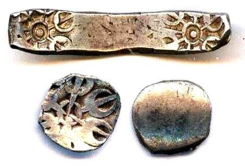

The wool of the Gandharis is referred to in the Rigveda. The Gandharas and their king figure prominently as strong allies of the Kurus against the Pandavas in the Mahabharata war. The Gandharas were furious people, well-trained in the art of war. According to Puranic traditions, this Janapada was founded by Gandhara, son of Aruddha, a descendant of Yayati. The princes of this country are said to have come from the line of Druhyu who was a famous king of the Rigvedic period and one of the five sons of king Yayati of lunar dynasty. The river Indus watered the lands of Gandhara. Taksashila and Pushkalavati, the two cities of this Mahajanapada, are said to have been named after Taksa and Pushkara, the two sons of Bharata, a prince of Ayodhya and younger brother of Lord Rama. According to Vayu Purana (II.36.107), the Gandharas were destroyed by Pramiti (a.k.a. Kalika) at the end of Kali Yuga. Pāṇini mentioned both the Vedic form Gandhari as well as the later form Gandhara in his Ashtadhyayi. The Gandhara kingdom sometimes also included Kashmira.[31] Hecataeus of Miletus (549–468) refers to Kaspapyros (Kasyapura or Purushapura, i.e., modern day Peshawar) as a Gandharic city. According to Gandhara Jataka, at one time, Gandhara formed a part of the kingdom of Kashmira. The Jataka also gives another name Chandahara for Gandhara.
Gandhara Mahajanapada of Buddhist traditions included territories of east Afghanistan, and north-west of the Punjab (modern districts of Peshawar (Purushapura) and Rawalpindi). Its later capital was Taksashila (Prakrit for Taxila). The Taksashila University was a renowned centre of learning in ancient times, where scholars from all over the world came to seek higher education. Pāṇini, the Indian genius of grammar and Kautiliya are the world-renowned products of Taxila University. King Pukkusati or Pushkarasarin of Gandhara in the middle of the 6th century BCE was the contemporary of king Bimbisara of Magadha. Gandhara was located on the northern high road (Uttarapatha) and was a centre of international commercial activities. According to one group of scholars, the Gandharas and Kambojas were cognate people.[32][33][34] It is also contended that the Kurus, Kambojas, Gandharas and Bahlikas were cognate people.[35] According to Dr T. L. Shah, the Gandhara and Kamboja were nothing but two provinces of one empire and were located coterminously, hence influencing each other's language.[36] Naturally, they may have once been a cognate people.[37] Gandhara was often linked politically with the neighboring regions of Kashmira and Kamboja.[38]
カンボジャ族もウッタラパタに含まれています。古代の文献では、カンボジャ族はガンダーラ、ダラダ、バフリカ(バクトリア)と様々に関連付けられています。古代のカンボジャはヒンドゥークシュ山脈の両側の地域から構成されていたことが知られています。元のカンボジャはバフリカの隣にあるオクサス地方の東部に位置していましたが、時が経つにつれて、カンボジャ族の一部の氏族はヒンドゥークシュ山脈を越えてその南側にも植民地を築いたようです。これらの後期のカンボジャ族は、インドの文献ではダラダやガンダーラと関連付けられており、アショーカ王の勅令にも言及されています。マハーバーラタとプトレマイオスの地理学の証拠は、2つのカンボジャ族の集落を明確に裏付けています。[ 39 ]ヌレスタンとギルギット・バルティスタンからカシミール南西部のラジャウリまで、ダラダスとガンダラと国境を接するヒンドゥークシュ山脈の南側の地域は、カンボジャ国を構成していた。[ 40 ]カンボジャの首都はおそらくカシミール南西部のラジャプラ(現在のラジョリ)であった。仏教の伝統におけるカンボジャ・マハージャナパダは、古代カンボジャのこのヒンドゥークシュ山脈の南側の支族を指している。[ 41 ]
パミール高原とバダフシャンを含むヒンドゥークシュ山脈以西の地域は、西側でバフリカ族(バクトリア)と、北側でソグディアナ/フェルガナのロハ族とリシカ族と国境を接しており、パラマ・カンボジャ国を構成していた。[ 42 ]ヒンドゥークシュ山脈以西のカンボジャ族は純粋なイラン系であったが、ヒンドゥークシュ山脈以西のカンボジャ族の大部分はインド文化の影響を受けたようである。カンボジャ族はイラン系とインド系の両方の親和性を持っていたことが知られている。[ 43 ] [ 44 ] [ 45 ] [ 46 ] [ 47 ] [ 48 ] [ 49 ] [ 50 ] [ 51 ] [ 52 ] [ 53 ]
カンボジャ族は叙事詩の時代からよく知られた共和制民族でもありました。マハーバーラタにはカンボジャ族のいくつかのガナ(共和国)について言及されています。 [ 54 ]カウティリヤのアルタシャーストラ[ 55 ]はカンボジャ族の共和制的な性格を証明しており、アショーカ王の勅令第13号もヤヴァナ族とともにカンボジャ族の存在を証明しています。[ 56 ]パーニニのスートラ[ 57 ]は、パーニニのカンボジャはクシャトリヤの君主制であったことを示唆していますが、カンボジャ族の支配者を表すために彼が与えた「特別な規則と例外的な派生形式」は、カンボジャの王が名目上の首長(王兼執政官)に過ぎなかったことを示唆しています。[ 58 ]仏教の経典によれば、上記のマハージャナパダのうち最初の14はマッジマデーシャ(中部インド)に属し、最後の2つはウッタラパタ、つまりジャンブドヴィーパの北西地域に属します。
紀元前6世紀/5世紀に起こった覇権争いで、成長を続けるマガダ国が古代インドで支配的な勢力となり、マッジマデーシャのいくつかのジャナパダを併合した。プラーナ文献には、マガダの皇帝マハパドマ・ナンダがすべてのクシャトリヤを滅ぼし、その後クシャトリヤの名にふさわしい者は一人も残らなかったと嘆く痛烈な一節がある。これは、伝説や詩以外では何も語られることのない東パンジャブのカーシー族、コーサラ族、クル族、パンチャーラ族、ヴァツヤ族、その他の新ヴェーダ部族を指している。(ナンダ族は紀元前345年頃にシシュナーガ王朝 の王位を簒奪し、ナンダ帝国を建国した。)[ 59 ]
しかし、カンボジャ人とガンダーラ人は、チャンドラグプタとカウティリヤが登場するまで、マガダ国と直接接触することはなかった。しかし、これらの国々は、キュロス2世の治世(紀元前558~530年)またはダレイオスの治世元年に、ペルシアのアケメネス朝の餌食となった。カンボジャとガンダーラは、アケメネス朝帝国の20番目で最も裕福なサトラピーを形成した。キュロス2世は、パロパミサデでカピシ(現在のベグラム)と呼ばれる有名なカンボジャの都市を破壊したと言われている。

王国は首都ヴァラナシ周辺に位置し、北はヴァルナ川、南はアッシ川に囲まれており、ヴァラナシという名前はこの川に由来する。仏陀以前、カーシーは16のマハージャナパダの中で最も強力であった。いくつかのジャータカ物語は、その首都がインドの他の都市よりも優れていることを証明し、その繁栄と富を高く評価している。これらの物語は、カーシーとコーサラ、アンガ、マガダの3つの王国との間の覇権をめぐる長い戦いを語っている。カーシーのブリハドラタ王はコーサラを征服したが、カーシーは後に仏陀の時代にカンサ王によってコーサラに併合された。カーシー人はコーサラ人やヴィデーハ人とともにヴェーダ文献に言及されており、緊密な同盟関係にあったようである。マツヤ・プラーナとアルビールーニーはカーシーをそれぞれカウシカとカウシャカと綴っている。他のすべての古代文献はカーシーと読んでいる。

コーサラ国はマガダ国の北西に位置し、首都はアヨーディヤーであった。その領土は、現在のウッタル・プラデーシュ州中部および東部のアーワド(またはアウド)地方に相当する。南はガンジス川、東はガンダク川(ナラヤニ川)、北はヒマラヤ山脈に囲まれていた。

その後、この王国はマハーヴィーラとブッダの時代に有名なプラセーナジット王によって統治され、その息子ヴィドゥダバ(ヴィルダカ)が後を継ぎました。プラセーナジット王は高度な教育を受けていました。彼の地位はマガダ国との婚姻同盟によってさらに向上しました。彼の妹はビンビサーラと結婚し、カーシーの一部が持参金として与えられました。しかし、パセーナディ(プラセーナジット)王とマガダ国のアジャータシャトル王の間で覇権争いがあり、最終的にリッカヴィ族の連合がマガダ国に征服されたことで決着しました。コーサラ国は最終的にヴィドゥダバが統治していた時にマガダ国に併合されました。アヨーディヤ、サケータ、バラナシ、シュラヴァスティはコーサラ国の主要都市でした。

The Puranas trace the origin of Kurus from the Puru-Bharata family. Kuru was born after 25 generations of Puru's dynasty, and after 15 generations of Kuru, Kauravas and Pandavas were born. Aitareya Brahmana locates the Kurus in Madhyadesha and also refers to the Uttarakurus as living beyond the Himalayas. According to the Buddhist text Sumangavilasini,[61] the people of Kururashtra (the Kurus) came from the Uttarakuru. Vayu Purana attests that Kuru, son of Samvarsana of the Puru lineage, was the eponymous ancestor of the Kurus and the founder of Kururashtra (Kuru Janapada) in Kurukshetra. The country of the Kurus roughly corresponded to the modern Thanesar, state of Delhi, and Meerut district of Uttar Pradesh. According to the Jatakas, the capital of the Kurus was Indraprastha (Indapatta) near modern Delhi which extended seven leagues. At Buddha's time, the Kuru country was ruled by a titular chieftain (king consul) named Korayvya. The Kurus of the Buddhist period did not occupy the same position as they did in the Vedic period but they continued to enjoy their ancient reputation for deep wisdom and sound health. The Kurus had matrimonial relations with the Yadavas, the Bhojas, Trigratas, and the Panchalas. There is a Jataka reference to king Dhananjaya, introduced as a prince from the lineage of Yudhishtra. Though a well known monarchical people in the earlier period, the Kurus are known to have switched to a republican form of government during the 6th to 5th centuries BCE. In the 4th century BCE, Kautiliya's Arthashastra also attests the Kurus following the Rajashabdopajivin (Royal Consul) constitution.


The Magadha was one of the most prominent and prosperous of Mahajanapadas.[62]

マガダ王国は、おおよそ現在のビハール州南部のパトナ県とガヤ県、および東のベンガル地方の一部に相当した。首都パタリプトラは、北はガンジス川、東はチャンパ川、南はヴィンディヤ山脈、西はソーナ川に囲まれていた。ブッダの時代には、その境界にはアンガも含まれていた。最古の首都はギリヴラジャまたはラージャガハ(現在のビハール州ナーランダー県のラージギル)であった。この都市の他の名前は、マガダプラ、ブリハドラタプラ、ヴァスマティ、クシャグラプラ、ビンビサラプリであった。ここは古代にはジャイナ教の活発な中心地であった。第一回仏典結集はヴァイバラ丘陵のラージャガハで開催された。その後、パタリプトラがマガダの首都となった。[ 63 ]


マッラカ族は仏教やジャイナ教の文献によく登場する。彼らは北インドに住んでいた有力な民族だった。マハーバーラタによれば、パンドゥプトラ・ビーマセーナは東インド遠征中にマッラカ族の首長を征服したとされている。仏教の時代、マッラカ・クシャトリヤは共和制の民族であり、その支配領域は9つの連合部族に対応する9つの領土[64]から成っていた。これらの共和制国家はガナサンガとして知られていた。これらの連合のうち2つ、すなわちクシナガラ(現在のゴラクプル近郊のカシア)を首都とするものと、パーヴァ(現在のファジルナガル、クシナガラの南東20キロメートル)を首都とするものは、ブッダの時代に非常に重要になっていた。クシナガラは、ブッダがパーヴァで最後の食事をとったことから、仏教の歴史において非常に重要な場所である。ブッダはパーヴァで病に倒れ、クシナガラで亡くなった。ガウタマ・ブッダはクシナガラのサスティパル・マール王の宮廷で亡くなったと広く信じられている。クシナガラは現在、ウッタル・プラデーシュ州観光開発公社によって開発が進められている仏教巡礼の中心地となっている。
マッラカ族は、リッチャヴィ族と同様に、マヌ法典ではヴラティヤ・クシャトリヤとして言及されている。マハッパルニッバーナ・スッタでは、彼らはヴァシシュタ(ヴァセッタ)と呼ばれている。マッラカ族は元々君主制の政体であったが、後にサンガ(共和制連合)に移行し、その構成員は自らをラージャと称した。マッラカ族は自衛のためにリッチャヴィ族と同盟を結んだようであるが、ブッダの死後まもなく独立を失い、その領土はマガダ帝国に併合された。

マツヤ族またはマッチャー族の国はクル族の南、ヤムナー川の西に位置し、ヤムナー川によってパンチャーラ族と隔てられていた。おおよそラージプーターナーのかつての藩王国ジャイプルに相当し、アルワール全域とバラトプルの一部を含んでいた。マツヤ族の首都はヴィラタナガラ(現在のバイラート)にあり、その名は建国王ヴィラタにちなんで名付けられたと言われている。パーリ語文献では、マツヤ族は通常スーラセーナ族と関連付けられている。西マツヤはチャンバル川の北岸の丘陵地帯であった。マツヤ族の一派は後世にヴィシャーカパトナム地域にも見られる。マツヤ族は仏陀の時代には政治的にそれほど重要な存在ではなかった。

パンチャラ族はクル族の東、山々とガンジス川に挟まれた地域を支配していた。その地域はおおよそ現在のウッタル・プラデーシュ州のブダウン、ファルカバード、および隣接する地区に相当する。この地域はウッタラ・パンチャラとダクシナ・パンチャラに分かれていた。北部のパンチャラの首都はアディチャトラまたはチャトラヴァティ(現在のバレイリー地区のラムナガル)にあり、南部のパンチャラの首都はファルカバード地区のカンピリヤまたはカンピルにあった。有名な都市カンヤクブジャまたはカナウジはパンチャラ王国に位置していた。元々は君主制の氏族であったパンチャラ族は、紀元前6世紀から5世紀にかけて共和制の共同体へと移行したようである。紀元前4世紀、カウティリヤの『アルタシャーストラ』にも、パンチャーラ朝がラージャシャブドパジーヴィン(王兼執政官)制に従っていたことが記されている。
スーラセーナの国はマツヤ川の東、ヤムナー川の西に位置していた。これはおおよそウッタル・プラデーシュ州、ハリヤナ州、ラージャスターン州のブリジ地方、およびマディヤ・プラデーシュ州のグワーリヤル地区に相当する。首都はマドゥラまたはマトゥラーにあった。スーラセーナの王アヴァンティプトラは、仏陀の主要な弟子の一人であり、彼の助けによって仏教はマトゥラー地方に広まった。マトゥラー/スーラセーナのアンダカ族とヴリシュニ族は、パーニニのアシュタディヤーイーで言及されている。カウティリヤのアルタシャーストラでは、ヴリシュニ族はサンガまたは共和国として記述されている。ヴリシュニ族、アンダカ族、およびシュールサイニの他の同盟部族はサンガを形成し、ヴァスデーヴァ(クリシュナ)はサンガ・ムキヤとして記述されている。スーラセーナ王国の首都マトゥラーは、メガステネスの時代にはクリシュナ信仰の中心地としても知られていた。スーラセーナ王国は、マガダ帝国に併合されたことで独立を失った。
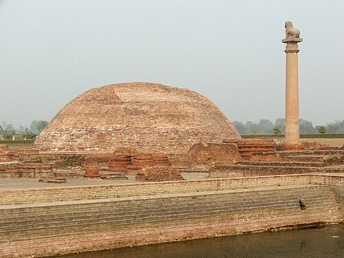
ヴァッジまたはヴリジは、リッチャヴィ族を含む近隣の氏族の連合体であり、古代インドの主要なマハージャナパダの1つでした。彼らが支配していた地域は、ネパールのミティラ地方と北ビハール地方を構成し、首都はヴァイシャリ市でした。 [ 66 ]
仏教の文献『アングッタラ・ニカーヤ』とジャイナ教の文献『バガヴァティ・スートラ』(第15章ウッデーサI)の両方が、ヴァッジを16のマハージャナパダのリストに含めている。 [ 67 ]このマハージャナパダの名前は、その支配氏族の1つであるヴリジ族に由来する。ヴァッジ国は共和制であったとされている。この氏族はパーニニ、チャナキヤ、玄奘三蔵によって言及されている。[ 68 ]

ヴァツァ族またはヴァムサ族はクル族の一派であると言われています。ヴァツァまたはヴァムサの国は、現在のウッタル・プラデーシュ州のプラヤーグラージの領土に相当します。この国は君主制で、首都はカウサンビー(プラヤーグラージから38マイル離れたコサム村と同一視される)でした。[ 69 ]カウサンビーは裕福な商人が多数住む非常に繁栄した都市でした。北西と南からの物資と乗客の最も重要な中継地でした。ウダヤナは紀元前6世紀から5世紀にかけてヴァツァを統治しました。彼は非常に強力で好戦的で狩猟を好みました。当初、ウダヤナ王は仏教に反対していましたが、後に仏陀の信者となり、仏教を国教としました。ウダヤナの母であるムリガヴァティ女王は、インドの歴史上最も初期の女性統治者の一人として知られています。
 Media related to Mahajanapadas at Wikimedia Commons