
Loading article…
キャナルストリート | |||||||||||||
|---|---|---|---|---|---|---|---|---|---|---|---|---|---|
 ニューヨーク市地下鉄 駅複合施設 ニューヨーク市地下鉄 駅複合施設 | |||||||||||||
 センターストリートの入り口 | |||||||||||||
| ステーション統計 | |||||||||||||
| 住所 | ブロードウェイとセンターストリートの間のキャナルストリート 、ニューヨーク、ニューヨーク | ||||||||||||
| 自治区 | マンハッタン | ||||||||||||
| ロケール | チャイナタウン、リトルイタリー、ソーホー | ||||||||||||
| 座標 | 北緯40度43分5秒 西経74度0分0秒 / 北緯40.71806度 西経74.00000度 / 40.71806; -74.00000 | ||||||||||||
| 分割 | A ( IRT )、B ( BMT ) [1] | ||||||||||||
| ライン | BMTブロードウェイ線 IRTレキシントンアベニュー線 BMTナッソーストリート線 | ||||||||||||
| サービス | 4  (深夜 (深夜) 6  (全回)<6> (全回)<6>  (平日20:45まで、ピーク方向) (平日20:45まで、ピーク方向)J (全回)いいえ (全回) 質問 (全回) R  (深夜を除く (深夜を除く) わ  (平日のみ) (平日のみ)ず (ラッシュアワー、ピーク方向) | ||||||||||||
| 交通 |  NYCTバス:M55 [2] NYCTバス:M55 [2] | ||||||||||||
| 構造 | 地下 | ||||||||||||
| レベル | 2 (マンハッタン ブリッジのプラットホームは斜めに交差し、他の 3 つの線路の下を通ります) | ||||||||||||
| その他の情報 | |||||||||||||
| オープン | 1917年9月4日(BMTマンハッタン橋とナッソーセント線の接続)1978年1月16日(IRTへの接続)[3] | ||||||||||||
| アクセス可能 |  部分的にADA 対応 (IRT レキシントン アベニュー ラインのプラットフォームのみ) 部分的にADA 対応 (IRT レキシントン アベニュー ラインのプラットフォームのみ) | ||||||||||||
| 渋滞 | |||||||||||||
| 2023 | 10,521,747 [4]  21.2% 21.2% | ||||||||||||
| ランク | 423人中17人[4] | ||||||||||||
| |||||||||||||
| |||||||||||||
| |||||||||||||








キャナルストリート駅は、ニューヨーク市地下鉄の駅舎です。マンハッタンのチャイナタウンとソーホー地区に位置し、BMT ブロードウェイ線、IRT レキシントン アベニュー線、BMT ナッソー ストリート線が乗り入れています。6 、J、N、Q系統が常時、R系統が深夜を除く常時、W系統が平日、<6>系統が平日のピーク時、Z系統がラッシュアワー時、4系統が深夜に運行しています。
この複合施設は 4 つの駅で構成され、すべてキャナルストリート駅と名付けられています。ブロードウェイ線の各駅停車と急行線は、別のプラットフォームに停車します。レキシントン アベニュー線のプラットフォームは、インターボロー ラピッド トランジット カンパニー (IRT)用に建設されたもので、ニューヨーク市初の地下鉄路線の各駅停車駅でした。この駅は、ニューヨーク市地下鉄の最初の 28 駅の 1 つとして、1904 年 10 月 27 日に開業しました。他の 3 つの駅は、デュアル コントラクトの一環として、ブルックリン ラピッド トランジット カンパニー(BRT、後のブルックリン・マンハッタン交通会社、または BMT) 用に建設されました。ナッソー ストリート線の駅は 1913 年 8 月 4 日に開業ブロードウェイ線のローカル駅は 1918 年 1 月 5 日に開業しました。IRT 駅と BMT 駅は 1978 年に接続されました。1999 年から 2004 年にかけての全面改装を含め、長年にわたりいくつかの改修が行われてきました。
レキシントン・アベニュー線駅は、ラファイエット・ストリートの下にあり、2面のプラットホームと4本の線路がある。急行列車は内側の2線を使って駅を迂回する。センター・ストリートの下にあり、ナッソー・ストリート線駅は、2面のプラットホームと3本の線路があるが、使用されているのは1面のプラットホームと2本の線路のみである。ブロードウェイの下にあり、ブロードウェイ各駅停車駅は、2面のプラットホームと4本の線路があるが、内側の2線は使用されていない。キャナル・ストリートの下にあり、ブロードウェイ急行駅は、2面のプラットホームと2本の線路があり、他の3組のプラットホームよりも低いレベルにある。レキシントン・アベニュー線のプラットホームには通りからエレベーターが設置されており、1990年のアメリカ障害者法に準拠しているが、その他のプラットホームは車椅子でアクセスできない。
歴史
最初の地下鉄
ニューヨーク市で地下鉄の計画が始まったのは1864年である。 [5] : 21 しかし、ニューヨーク市初の地下鉄の開発は、1894年にニューヨーク州議会が高速交通法を可決するまで開始されなかった。 [5] : 139–140 地下鉄の計画は、高速交通委員会の主任技師ウィリアム・バークレー・パーソンズが率いる技術者チームによって作成された。計画では、マンハッタン南部のニューヨーク市庁舎からアッパー・ウエスト・サイドまでの地下鉄路線が提案され、そこから2本の支線が北のブロンクスへと伸びる予定であった。[6] : 3 計画は1897年に正式に採用され、[5] : 148 路線配置に関するすべての法的紛争は1899年末近くに解決されました。[5] : 161 ジョン・B・マクドナルドが組織し、オーガスト・ベルモント・ジュニアが資金を提供したラピッド・トランジット建設会社は、1900年2月にラピッド・トランジット委員会と最初の契約1を締結し、[7]地下鉄を建設し、路線の開通から50年間の営業リースを維持することになりました。[5] : 165 1901年、ハインズ&ラファージ社が地下鉄駅の設計に採用されました。[6] : 4 ベルモントは、地下鉄を運営するために1902年4月にインターボロー・ラピッド・トランジット・カンパニー(IRT)を設立しました。[5] : 182

キャナル ストリート駅は、チェンバーズ ストリートからグレート ジョーンズ ストリートまでの路線区間の一部として建設されました。この区間の建設は 1900 年 7 月 10 日に始まり、デグノン-マクリーン コントラクティング カンパニーに発注されました。[7]キャナル ストリートの近くで、地下鉄は排水下水道 (キャナル ストリートの名前の由来) を通過しました。この下水道は、古いコレクト ポンドを排水し、西のハドソン川まで続いていました。[8] [9] : 220 技術者は池の近くで流砂が見つかると予想していたため、請負業者はパール ストリートとキャナル ストリートの間の区間の建設を待ちました。[10] [11]この区間の作業は 1902 年初頭までに開始されていませんでした。[12]作業員は、地面が予想よりも頑丈で、「良質で粗い砂利」でできていることを発見しました。[9] : 230 また、木の幹や人骨、コイン、銀食器、鍵、鋼鉄の道具などの遺物も発見しました。[8]さらに、地面はまだぬかるんでいたため、作業員は水を汲み出さなければならなかった。[10] IRTの建設に伴い、下水道は東に迂回され、イースト川に流れ込んだ。[9] : 240 [13]新しいレンガ造りの下水道は円形で、幅は5.5フィート (1.7 m) で、チャタムスクエアでは6.5フィート (2.0 m) に拡張された。[9] : 240 作業が進む間、掘削箇所に水が入らないようにポンプが使用された。[5] : 267 1903年後半までに、駅の上の道路の表面は修復され、再舗装された。[14]地下鉄はほぼ完成していたが、IRT発電所とシステムの変電所はまだ建設中であり、システムの開通が遅れていた。[5] : 186 [15]
キャナル ストリート駅は、1904 年 10 月 27 日に開業し、ニューヨーク市地下鉄の当初の 28 駅のうちの 1 つとして、ブロードウェイ-7 番街線のシティ ホールから145 丁目までを結んでいた。[16] [5] : 186 1908 年に最初の地下鉄路線が完成すると、[17]この駅にはウエスト サイド (現在のブロードウェイ-7 番街線からヴァン コートランド パーク-242 丁目まで) とイースト サイド (現在のレノックス アベニュー線) の両方で各駅停車が運行された。ウエスト サイドの各駅停車の南終点はラッシュ アワーにはシティ ホール、その他の時間帯にはサウス フェリー、北終点は242丁目であった。イースト サイドの各駅停車
1909年、ニューヨーク公共サービス委員会は、混雑に対処するため、当初のIRT地下鉄沿いの駅のプラットホームを延長することを提案した。[19] : 168 1910年1月18日に締結されたIRTの建設契約の変更の一環として、同社は駅のプラットホームを延長し、10両編成の急行列車と6両編成の普通列車を収容することになっていた。プラットホームの延長に費やされた150万ドル(2023年の4910万ドルに相当)に加えて、追加の出入口の建設に50万ドル(2023年の1640万ドルに相当)が費やされた。これらの改良により、収容能力が25パーセント増加すると予想された。[20] : 15 キャナルストリート駅などのローカル駅のプラットホームは、20〜30フィート(6.1〜9.1メートル)延長された。両方のプラットホームが南北に延長された。[20] : 107 1910年10月に6両編成の普通列車の運行が開始された。[19] : 168
BRTと二重契約
最初のIRTが開通した後、市は新しい路線の計画を始めた。1908年初頭には、ブロードウェイ・レキシントン・アベニュー線とナッソー・ストリート線、ブルックリンのフォース・アベニュー地下鉄からマンハッタン橋を経由してハドソン川に至るキャナル・ストリート地下鉄、およびブルックリンの他のいくつかの路線を組み合わせたトライ・ボロー・システムの提案が採用された。これらの路線は、1913年3月4日に採択された二重契約でブルックリン高速交通会社(BRT、1923年以降はブルックリン・マンハッタン交通公社またはBMT [21])に割り当てられた。 [5] : 203–219 [22] [23] BRTは、キャナル・ストリートに駅があるブロードウェイの下の路線と、ブロードウェイに駅があるキャナル・ストリートの下の路線を建設することを許可された。[24] BRT駅の開発により、その地域の不動産価値が上昇した。[25]
また、デュアルコントラクトの一環として、 1918年にグランドセントラル駅の北側、42丁目にレキシントン・アベニュー線が開通し、当初の路線はH字型のシステムに分割されました。すべてのローカル列車はレキシントン・アベニュー線を経由してブロンクスのペラム線に沿って運行されました。[26]
センターストリートループ
パーソンズは1902年には既に、ロウアー・マンハッタンのセンター・ストリートの下に地下鉄を敷設する計画を立案していた。この路線はブルックリン橋から北のキャナル・ストリートまで4本の線路で構成され、そこから2本の線路が東に分岐してマンハッタン橋に至り、さらに2本の線路が北と東に進んでウィリアムズバーグ橋に至る予定だった。[27] 1904年までに路線はブルックリン橋からウィリアムズバーグ橋まで4線に拡幅された。[28] [29]センター・ストリート・ループ(後のナッソー・ストリート線)は1907年1月25日に4線路の路線として承認された。[30] [31]この路線はブルックリン橋、マンハッタン橋、ウィリアムズバーグ橋をセンター・ストリート、キャナル・ストリート、デランシー・ストリートを経由して結び、キャナル・ストリートの下に支線を設けることになっていた。[30] [32]市政府がこれまでに発行した地下鉄契約とは異なり、BRTはセンターストリートループの建設と設備の設置のみを担当し、ループの運営は担当していなかった。[33]
工事は5つのセクションに分かれており、キャナルストリート駅はセンターストリートの下を通る2つのセクションの一部として建設されました。[34]市は1907年3月にこれらのセクションの入札を受け付け始めました。 [35] [36]デグノン建設会社はキャナルストリート北からブルームストリートまでのセクション9-0-2の建設に雇われ、クランフォード会社がキャナルストリート南からパールストリートまでのセクション9-0-3の建設に雇われました。[34]線路は、まだ地下水の量が多いコレクトポンドの旧跡を通って建設する必要がありました。請負業者が地下水を排水したため、近くの裁判所の建物に大きな亀裂が生じました。[37]
センターストリートループ駅は、キャナルストリートに計画されていた線路をまたぐ橋梁を含めて、1909年末に完成した。センターストリートループの終点であるチェンバーズストリート駅が完成していなかったため、この駅は閉鎖されたままだった。 [38]センターストリートの下のBRTトンネルは、未完成のチェンバーズストリート駅があったマンハッタン市庁舎の下のセクションを除いて、1910年までに完成した。[39] [40]このトンネルは数年間使われなかった。[41] 1913年3月、公共サービス委員会はBRTに線路の敷設、信号の設置、ループの運営を認可した。[41] [42]ナッソーストリートラインのプラットフォームは1913年8月4日に開業し、[43] [44]ウィリアムズバーグ橋を経由してブルックリン北部へのサービスを提供した。[5] : 249 [43]
マンハッタンブリッジライン
IRTは1908年にキャナルストリート沿いにマンハッタン橋を渡ってブルックリンの現在のイースタンパークウェイ線と接続する複線の地下鉄路線を建設する提案をしたが、失敗に終わった。 [45] [46] BRTは翌年、キャナルストリートとマンハッタン橋を渡ってブライトンビーチ線と接続する路線を建設することを提案した。[47] [48] BRTは1911年3月2日付けで委員会に、トライボローシステム(ただしグリニッジストリートの代わりにチャーチストリートの下)と、ブロードウェイ、セブンスアベニュー、59番街に沿った支線を9番街から北と東にクイーンズボロ橋まで運営する提案を提出した。キャナルストリートの地下鉄はハドソン川まで続くのではなく、ブロードウェイ線と合併することになっていた。[5] : 225 キャナルストリートトンネルはもともとブロードウェイ線の駅の下を通り、さらに西に延びる別の線路になる予定だった。[49] [50]当時、公共サービス委員会は、キャナルストリート線とブロードウェイ線の間に線路を接続する計画を立てていなかった。そのような接続は深刻な列車混雑を引き起こすからだ。BRTは、キャナルストリート駅で乗客が乗り換えたり、緊急時に列車のルートを変更したりすることが困難であるという事実を理由に、線路の接続を望んでいた。[50]
二重契約が締結された時点では、計画は修正され、マンハッタン・ブリッジ線がブロードウェイ線に接続されることになっていた。[23] [51]この接続には、追加で100万ドルの費用がかかると見積もられていた。[52] 1913年10月、公共サービス委員会は、BRTの親会社であるニューヨーク市当局に対し、キャナル・ストリート線とブロードウェイ線の接続工事に関連する作業に対して、アンダーピニング・アンド・ファウンデーション・カンパニーに約1万2千ドルを支払うよう命じた。[53]当時、アンダーピニング・アンド・ファウンデーション・カンパニーは、ブロードウェイ線のハワード・ストリートから北のブリーカー・ストリートまでの区間を建設しており、ニューヨーク市当局は最終的に、接続のために請負業者にさらに41万2千ドルを支払わなければならなかった。[54]委員会は1914年2月までに、ブロードウェイ本線から分岐し、キャナルストリートの下を東にマンハッタン橋まで延びるトンネルの入札を募集していた。かつてのコレクト池の存在によりこの地域は湿地帯であったため、委員会は開削工法か深掘りトンネルのどちらかで路線を建設することを検討した。[55] [56]アンダーピニング・アンド・ファンデーション・カンパニーは1914年5月に開削トンネルに182万2000ドルという低価格の入札を行い、[57] [58] 2か月後に同社が駅の建設に選ばれた。[59]
マンハッタン橋の工事はゆっくりと進んだが、[60]その一因は、その地域の地下水位が高く、請負業者が毎日何百万ガロンもの地下水を汲み出す必要があったことであった。[49] [61]キャナル通り沿いの古い運河は埋め立てられたが、地面にはまだかなりの量の水が残っていた。[62]マンハッタン橋は、古いコレクト池の底、つまり以前の池の水位より約35フィート (11 m) 下に建設される予定であった。[62] [63] サン紙は、「問題の解決策は、ある意味ではパナマ運河の建設者が直面した問題と同じくらい大きなものである」と書いた。[62] 1日中毎分約6,000~7,000米ガロン(23,000~26,000リットル)の水を常時汲み出さなければならず、[64]これは24時間あたり約1000万米ガロン(38,000,000リットル、8,300,000英ガロン)に相当します。[65] : 27 [63]その後、作業員は現場から砂と砂利を掘り出しました。[65] : 27 さらに、マンハッタン・ブリッジ線の駅を掘削した際に、IRT駅が約2.5インチ(64 mm)沈下しました。 [63] 1915年半ばまでにプロジェクトの3分の1しか完成していませんでした。[49]マンハッタン・ブリッジ線は1916年1月までに半分以下しか完成しておらず、[66]同年10月までに80%完成していました。[67]マンハッタン・ブリッジ線のプラットホームは、ブロードウェイ線の最初の区間であるキャナル・ストリートから14番街・ユニオン・スクエアまでの一部として1917年9月4日に開業した。[68] [69] [70]
ブロードウェイ本線
ニューヨーク公益事業委員会は、 1907年12月31日にブロードウェイ・レキシントン・アベニュー路線(後のブロードウェイ本線)として知られる路線の計画も採択した。 [5] : 212 ブロードウェイ・レキシントン・アベニュー線の駅の一覧は1909年に発表され、計画では暫定的にロウアー・マンハッタンのキャナル・ストリートに急行駅を設けることになっていた。[71] [72]キャナル・ストリート周辺のブロードウェイ線の2つの区間は、1912年初頭に契約された。[5] : 225 マレー・ストリートとキャナル・ストリートの間のセクション2の契約は、その年の1月にデグノン・コントラクティング・カンパニーに交付された。[73] 2ヵ月後、キャナル・ストリートとハワード・ストリートの間に伸び、キャナル・ストリート駅を含むセクション2Aの契約は、オルーク・エンジニアリング・コンストラクション・カンパニーに交付された。[74] [75]セクション2Aは1913年初頭までに12%完成しました。[76] [77]セクション2の作業はさらに進み、その年の6月までに60%が完了しました。[78]
ブロードウェイ本線の駅の設計は、建設の途中でマンハッタン・ブリッジ線への線路接続が追加された際に変更された。[49]駅の当初の計画では、本線の中央線はブロードウェイまで続き、ブルックリンとモンタギュー・ストリート・トンネルからの交通が供給されることになっていた。各駅停車はブロードウェイ線のシティ・ホール駅の上層階で終了し、急行はシティ・ホールの上層階を使用する予定だった。新しい計画では、各駅停車はシティ・ホールの上層階を、急行はマンハッタン・ブリッジを通ることになり、本線駅の中央線はシティ・ホールの下層階の未使用のプラットホームに接続するため廃止された。[5] : 225
ブロードウェイ線の14丁目以南は、1916年2月までにほぼ完成していた。[79] [80]同月、公共サービス委員会は、キャナルストリートを含む、レクターストリートから14丁目までのブロードウェイ線の7つの駅で仕上げ工事を行うための入札の受付を開始した。[79] [80] DC ガーバーは仕上げ工事に対して34万6000ドルという低価格の入札を行い、 [81] 1916年10月までに仕上げ工事の35%を完了した。[67]本線のプラットフォームは、ブロードウェイ線が北はタイムズスクエア–42丁目まで、南はレクターストリートまで延長された1918年1月5日に開業した。当初から、本線の駅は各駅停車、マンハッタンブリッジ線の駅は急行列車の運行を開始した。[82] [83]
1910年代から1930年代
リークとプラットフォーム拡張

マンハッタン・ブリッジ線の駅は1918年4月までに目立った漏水を始めていたが、[84] [85]その主な原因は、その地域の地下水量が多かったことであった。[84]駅は防水アスファルトとレンガの膜で建設されていたが、その地域には依然として大量の地下水があり、地下水の圧力で膜が割れていた。[86]漏水は非常に深刻になり、駅に毎分最大150米ガロン(570リットル、120英ガロン)が漏水した。[63] [87] 1918年後半、漏水を止めるためにアンダーピニング・アンド・ファンデーション・カンパニーが駅のグラウト充填のために2万ドルで雇われた。[88]作業員が駅を修理できるように、BRTは深夜に単線でキャナル・ストリートからパシフィック・ストリートまでシャトルサービスを運行した。 [88] [89]工事は1919年4月までに完了し、[86] [87]その後、漏水はほぼ完全に止まりました。[87] [90]グラウト工事の副作用として、IRT駅の沈下が修正されました。[63]
1922年、ラピッド・トランジット委員会は、ワグナー・エンジニアリング社に、キャナル・ストリート駅と他のいくつかの主要な地下鉄駅の案内標識の設置を委託した。IRTのプラットホームには青と白の標識が、BMTのプラットホームには赤、白、緑の案内標識が取り付けられた。[91] [92]その年の12月、委員会は、キャナル・ストリート駅とレキシントン・アベニュー線の7つの駅を含む、元のIRT線沿いの14のローカル駅のプラットホームを延長する300万ドルのプロジェクトを承認した。これらの駅のプラットホームの長さは、225フィートから436フィート(69メートルから133メートル)に延長される予定だった。[93] [94]委員会は、1923年9月にプラットホーム延長プロジェクトを延期したが、その時点でコストは560万ドルに上昇していた。[95] [96 ] 1926年、ニューヨーク市交通局は、ブロードウェイ線の9つの駅(キャナルストリートの主要駅を含む)のプラットホームを8両編成の列車に対応できるように延長する入札を受けた。エドワーズ&フラッド社は、このプロジェクトに対して101,775ドルという低価格の入札を提示した。[97] BMTプラットホーム延長プロジェクトは1927年に完了し、プラットホームの長さは535フィート(163メートル)になった。[98] [99]委員会は、1930年半ばにBMTにキャナルストリートBMT駅に追加の標識を設置するよう命じた。[100]
一方、1927年12月、委員会は再びキャナルストリートのIRTプラットホームの延長を検討した。プラットホームは南のワースストリート駅の方向に延長され、ワースストリート駅のプラットホームは延長されないことになっていた。[101] [102]その月の終わりに、交通委員会はIRTにキャナルストリートと他の3つのレキシントンアベニュー線の駅のプラットホームを480フィート (150 m) 延長する計画を作成するように要請した。[103]ニューヨーク市交通委員会がこのプロジェクトの計画を作成したが、[104]連邦政府は委員会のプラットホーム延長命令に対して差し止め命令を出し、それは1年以上も有効のままだった。[105]委員会は1929年半ばに計画を承認し、キャナルストリート駅のプラットホームは南に256フィート (78 m) 延長されることになっていた。[104] IRTは、工事の責任は市政府にあると主張して拒否し、委員会がIRTにプラットフォームの延長を強制するのを阻止するための連邦差止命令を獲得した。[106] 1930年後半、委員会はニューヨーク州最高裁判所にIRTにキャナルストリート駅とスプリングストリート駅のプラットフォームを延長するよう強制するよう要請した。[107]
過密問題
キャナル ストリートの BRT 駅が開業した後、この複合施設は BRT 路線の主要な乗り換え拠点となったが、異なるプラットフォームは狭い通路でしかつながっていなかった。[108]センター ストリート線の乗客がミッドタウン マンハッタン行きの BRT 列車に乗り換えられるのは、この駅のみであったこと、[109] [110]階段や通路のレイアウトが複雑であること、[111]方向標識がないことなどにより、混雑は悪化した。[112] 1918 年までに、地元の市民団体は、キャナル ストリートの混雑を緩和するために、BRT のカナーシー線 (ユニオン スクエアでブロードウェイ線に乗り換え可能) の開通を主張していた。 [113] 公共サービス委員会は、デュアル コントラクトの一環として、この路線を開通させる義務があった。[114] [115]ブロードウェイ商品取引所は、この駅を「生命と身体に対する脅威」と呼んだ。[116]これを受けて、1918年2月に公共サービス委員会は、出口階段を2つ建設し、センターストリートループ列車の一部がキャナルストリート駅を経由しないようにすると発表した。[117] BRTはまた、交通整理のためにプラットフォームに常駐するスタッフを雇用した。[118]
1920年6月、BRTはラッシュアワー時にナッソーストリート線とブロードウェイ線の間で乗り換える場合、乗客に駅から出るよう要求し始めた。乗客には午前中はナッソーストリート線からブロードウェイ線への乗り換え券が発行され、午後はその逆となった。[119] [120]混雑をさらに緩和するため、交通委員会は1922年半ばにセンターストリートとウォーカーストリートの南西角に新しい入口を設ける計画を策定するよう要請した。[121]さらに、ブロードウェイ協会は、2つの駅間の距離が異常に長いため、ブロードウェイ線のキャナルストリートとシティホールの間に駅を建設するよう要請した。[122] 1924年までに、BMTの役員は、キャナルストリートの混雑で誰かが死ぬとすれば、ジョン・フランシス・ハイラン市長の責任になると述べた。[123] [124]翌年、BMTはカナルストリートの混雑を緩和するためにカナルシー線を完成させることに同意した。[125]カナルシー線の列車は1928年にようやくブルックリンまで直通運転を開始し、[126]これによりBMTはラッシュアワー時にカナルストリートで1日38,000回の乗り換え便を発行していた。[127]カナルシー線にブルックリン直通サービスが追加されたことでカナルストリート駅の混雑が緩和され、[108] [127]カナルストリートの連絡通路は1928年8月に再開された。[108]
1940年代から1980年代
市政府は1940年6月1日にBMTの運営を引き継ぎ、[128] [129] 1940年6月12日にIRTの運営を引き継いだ。 [130] [131]ニューヨーク市交通局は1947年4月に、キャナルストリートとワースストリートの南行きIRTプラットフォームを10両編成の列車が通れるように延長する199万2000ドルの契約を交付した。[132] [133]工事は翌年に完了した。[133] 1959年後半、 IRTレキシントンアベニュー線のボウリンググリーン、ウォールストリート、フルトンストリート、キャナルストリート、スプリングストリート、ブリーカーストリート、アスタープレイス、グランドセントラル–42丁目、86丁目、125丁目のプラットフォームを525フィート (160 m) まで延長する契約が締結された。[134]翌年4月、これらの駅のうち7つの駅でプラットホームを延長し、10両編成の列車を収容できるようにする350万9000ドル(2023年には3610万ドルに相当)のプロジェクトが開始されました。キャナルストリート、スプリングストリート、ブリーカーストリート、アスタープレイスの北行きプラットホームは225フィートから525フィート(69メートルから160メートル)に延長され、これらの駅のプラットホーム延長は1962年2月19日にオープンしました。[135]
1960年代後半、ニューヨーク市交通局はブロードウェイ線の両プラットホームを拡張し、10両編成の列車を収容できるようにした。[136]また、ニューヨーク市交通局は、ブロードウェイ線とフォースアベニュー線の16のローカル駅(キャナルストリートのブロードウェイ本線とマンハッタンブリッジ線のプラットホームを含む)の精巧なモザイクタイルの壁を、8×16インチ(20×41cm)の白いコンクリートブロックタイルで覆った。 [137]
キャナル・ストリートとセンター・ストリート、およびキャナル・ストリートとブロードウェイの駅係員のブースは、経費節減のため1976年に閉鎖された。これらのブースは1978年に部分的に再開された。[138] 1978年1月16日、レキシントン・アベニュー線とBMTプラットフォーム間の乗り換えは運賃管理の対象となった。[3] [139]この無料乗り換えは、乗客数の増加を促すことが目的であった。以前は、BMT駅はすべて互いに接続されていたが、BMTとIRT間の乗り換え客は2回目の運賃を支払わなければならなかった。[140] [141]
1990年代から現在

1990年の3ヶ月間を除き、マンハッタン橋の南側の地下鉄線路の再建工事中、1988年から2001年までマンハッタン橋線のプラットホームへの列車の運行は停止されていた。プラットホームは複合施設内の他のプラットホームとの接続が唯一のものであったため、他の路線との乗り換え客のために開いたままであった。マンハッタンとブルックリンの間のサービスは本線プラットホームにリダイレクトされ、モンタギュー・ストリート・トンネルが使用された。橋の工事が行われていない3ヶ月間は列車の運行が許可されるはずだったが、1990年12月27日、橋の完全性を脅かす鋼板の欠落と腐食が発見され、このサービスは停止された。[142] [143] 1990年代には、使用されていない支線にゴミが堆積し、天井とタイルに水害が発生した。[144] 1997年、アレクサンダー・ブロツキーによる「キャナル・ストリート・カナル」として知られる一時的な芸術展示が北行きの線路に設置されました。 [145]これは、ブロツキーがMTAアーツ・フォー・トランジットのデザインコンペで優勝した後のことでした。[146]それは、水を満たした大きな防水浴槽で構成され、中にはベネチアの運河船が浮かんでいました。[146] [147]
1993年4月、ニューヨーク州議会はMTAに資本改善のために96億ドルを与えることに同意した。資金の一部は、キャナルストリート複合施設全体を含むニューヨーク市地下鉄の約100の駅の改修に使用される予定だった。[148] [149] [150]改修工事は1994年5月に始まり、その時点では4,400万ドルの費用がかかるとされていた。周辺地域への影響を最小限に抑えるため、作業員は夜間のみ掘削作業を行った。[151]工事には、階段の改造、壁のタイル張り替え、床のタイル張り替え、駅の照明と拡声システムのアップグレード、新しい照明の設置、エレベーター2基の設置が含まれていた。[151]エレベーターにより、レキシントン・アベニュー線のプラットフォームは1990年のアメリカ障害者法(ADA)に準拠するようになった。[152]
このプロジェクトは当初、1997年12月に完了する予定だった。[151] [153] MTAは改修中に駅のツアーを主催し、工事の詳細を見たい一般の人々にチケットを販売した。[154]改修中の1995年10月、作業員が誤ってフーロンプラザという隣の建物の基礎に穴を開け、その建物が傾いた。[155]水道管の破裂もプロジェクトを遅らせた。[156] 1999年半ばまでに、駅の改修の完了は2000年11月まで3年近く延期された。[153] [156]マンハッタンブリッジの南側の線路の再開に先立ち、マンハッタンブリッジ線のプラットフォームも新しい照明、タイル、第三軌条で改装された。[144]マンハッタンブリッジ線のプラットフォームは2001年7月22日に再開された。[157] [158]
駅のレイアウト
この複合施設は、もともと別々だった4つの駅が地下通路でつながっている。4つのうち3つは南北方向に走っており、ブロードウェイ(ブロードウェイ本線)、ラファイエットストリート(レキシントンアベニュー線)、センターストリート(ナッソーストリート線)で交差している。マンハッタンブリッジ線のプラットフォームはキャナルストリートの真下にあり、西から東に伸びている。[65] : 25 ブリッジ線のプラットフォームは、他のすべての路線間の乗り換え通路として機能している。キャナルストリートを出た後、マンハッタンブリッジ線は北に向かって右折し、ブロードウェイに入る。
この駅はチャイナタウン、リトルイタリー、ソーホー、トライベッカなど複数の地区にサービスを提供しています。[151]キャナルストリート複合施設内の駅の相対的な深さは次のとおりです。
- IRTレキシントン・アベニュー線、道路下20フィート(6.1メートル)
- BMTブロードウェイ線、本線、20フィート(6.1メートル)
- BMTナッソーストリート線、40フィート(12メートル)
- BMTブロードウェイ線マンハッタンブリッジ支線55フィート(17メートル)[62]
出口

複合施設には、レキシントン・アベニュー線のプラットホームへの階段入口が合計13箇所とエレベーター入口が2箇所ある。ブロードウェイ本線プラットホームからは、北西、南東、南西の角にそれぞれ2つの階段がある。また、ブロードウェイとキャナル・ストリートの北東の角にも階段がある。ナッソー・ストリート線からは、センター・ストリートとキャナル・ストリートの南西の角に階段がある。マンハッタン・ブリッジ支線プラットホームの出口は、レキシントン・アベニュー線のプラットホームでも使用されている。北行きレキシントン・アベニュー線プラットホームからは、ラファイエット・ストリートとキャナル・ストリートの東の角に続く階段が3つあり、そのうち1つは北東の角、2つは南東の角に続いている。南行きレキシントン・アベニュー線プラットホームからは、ラファイエット・ストリートとキャナル・ストリートの西の角に続く階段がある。[159]
キャナル通りとラファイエット通りの交差点にある2つのエレベーターにより、レキシントン・アベニュー線の駅は1990年のアメリカ障害者法(ADA)に基づいてアクセス可能となっている。北行きのプラットホームのエレベーターは北東の角にあり、南行きのプラットホームのエレベーターは北西の角にある。[152]複合施設内の他のプラットホームはADAアクセス可能ではない。[160] : 2
キャナル ストリート複合施設には閉鎖された出口がいくつかある。そのような出口の 1 つは、キャナル ストリートとセンター ストリートの北東の角にある建物に通じていた。 [161] 1996 年の改修中に、この出口は非常口になった。[154]同じ交差点の南東の角にある 2 つの階段 (北行きのプラットフォームにのみ接続) は、1995 年の近隣地図に示されているが、[162] 1999 年までに撤去された。[163]キャナル ストリートとラファイエット ストリートの交差点には、北東の角、[164]北西の角、[165]南西の角にも階段があった。[166]
IRTレキシントンアベニューラインのプラットフォーム
キャナルストリート | ||||||||||||||||||||||||||||||||||||||||||||||||||||||||||||||||||||
|---|---|---|---|---|---|---|---|---|---|---|---|---|---|---|---|---|---|---|---|---|---|---|---|---|---|---|---|---|---|---|---|---|---|---|---|---|---|---|---|---|---|---|---|---|---|---|---|---|---|---|---|---|---|---|---|---|---|---|---|---|---|---|---|---|---|---|---|---|
| ニューヨーク市地下鉄駅(高速鉄道) | ||||||||||||||||||||||||||||||||||||||||||||||||||||||||||||||||||||
 北行きホームから出発するR62A 6列車 | ||||||||||||||||||||||||||||||||||||||||||||||||||||||||||||||||||||
| ステーション統計 | ||||||||||||||||||||||||||||||||||||||||||||||||||||||||||||||||||||
| 分割 | A ( IRT ) [1] | |||||||||||||||||||||||||||||||||||||||||||||||||||||||||||||||||||
| ライン | IRTレキシントンアベニュー線 | |||||||||||||||||||||||||||||||||||||||||||||||||||||||||||||||||||
| サービス | 4 (深夜 ) 6 (全回)<6> (平日20:45まで、ピーク方向) | |||||||||||||||||||||||||||||||||||||||||||||||||||||||||||||||||||
| 構造 | 地下 | |||||||||||||||||||||||||||||||||||||||||||||||||||||||||||||||||||
| プラットフォーム | 2つのサイドプラットフォーム | |||||||||||||||||||||||||||||||||||||||||||||||||||||||||||||||||||
| トラック | 4 | |||||||||||||||||||||||||||||||||||||||||||||||||||||||||||||||||||
| その他の情報 | ||||||||||||||||||||||||||||||||||||||||||||||||||||||||||||||||||||
| オープン | 1904年10月27日[16] | |||||||||||||||||||||||||||||||||||||||||||||||||||||||||||||||||||
| アクセス可能 | ADA 対応 (他の路線への乗り換えはできません。また、北行きと南行きのプラットフォーム間の乗り換えもできません) | |||||||||||||||||||||||||||||||||||||||||||||||||||||||||||||||||||
| 逆 方向 転送 | はい | |||||||||||||||||||||||||||||||||||||||||||||||||||||||||||||||||||
| ||||||||||||||||||||||||||||||||||||||||||||||||||||||||||||||||||||
| ||||||||||||||||||||||||||||||||||||||||||||||||||||||||||||||||||||
| ||||||||||||||||||||||||||||||||||||||||||||||||||||||||||||||||||||
| ||||||||||||||||||||||||||||||||||||||||||||||||||||||||||||||||||||








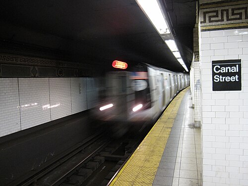
IRTレキシントン・アベニュー線のキャナル・ストリート駅は、 4本の線路と2つの側線プラットフォームを持つローカル駅である。6番線は常時ここに停車し、[167]ラッシュアワーと正午の<6>系統の列車はピーク方向でここに停車し、[167] 4番線は深夜にここに停車する。[168] 2本の急行線は、日中の時間帯に4番線と5番線が使用する。 [169]駅は、北はスプリング・ストリート、南はブルックリン・ブリッジ・シティ・ホールの間にある。 [170]地下鉄が開通したとき、南の次のローカル駅はワース・ストリートだったが、[16]この駅は1962年に廃止された。[171]プラットフォームは元々、他のIRTローカル駅と同様に200フィート (61 m) の長さで、[6] : 4 [172] : 8で あったが、1959年のプラットフォーム拡張の結果、長さは525フィート (160 m) になった。[134]プラットホームの延長部分は、元々のプラットホームの北端にある。[172] : 32
元々のIRTの一部として建設された他の駅と同様に、この駅も開削工法で建設された。[9] : 237 トンネルはU字型のトラフで覆われており、その中にユーティリティパイプや電線が通っている。このトラフの底には、厚さ4インチ (100 mm) 以上の基礎コンクリートがある。 [172] : 9 各プラットホームは厚さ3インチ (7.6 cm) のコンクリートスラブで構成され、その下には排水枡がある。プラットホームには、15フィート (4.6 m) 間隔で白の艶出しタイルを貼った柱がある。線路の間には5フィート (1.5 m) 間隔で追加の柱があり、ジャックアーチ型のコンクリート駅舎の屋根を支えている。[6] : 4 [172] : 9 トラフ壁とプラットホーム壁の間には1インチ (25 mm) の隙間があり、プラットホーム壁は4インチ (100 mm) 厚のレンガでできており、その上にタイルが貼られている。[172] : 9 1910年代後半、請負業者は駅の防水工事を行い、線路床の下に5インチ (13 cm) 厚のレンガと6インチ (15 cm) 厚のコンクリートの層を敷いた。レンガとアスファルトコンクリートの擁壁が、レキシントン・アベニュー線駅の下のブリッジ線プラットホームの両側に建設され、新しい屋根桁が建設されてレキシントン・アベニュー線がブリッジ線の上に架けられた。[65] : 27
当初の装飾は、青と緑のタイルの駅名板、緑のタイルの帯、淡黄褐色のテラコッタのコーニス、緑のテラコッタの銘板で構成されていた。[172] : 32 当初のIRT駅のモザイクタイルは、各駅での設置を下請けにしたAmerican Encaustic Tile Companyによって製造された。[172] : 31 テラコッタの銘板には、小川にかかる橋の隣にある小さな家が描かれている。[173]装飾作業は、タイル業者のManhattan Glass Tile Companyとテラコッタ業者のAtlantic Terra Cotta Companyによって行われた。[172] : 32 当初のプラットホームと運賃管理エリアの天井には、石膏モールディングが含まれている。[172] : 10 新しい部分には、プラットホームの端に1950年代の緑のタイルが貼られている。インディペンデント サブウェイ システム(IND) タイプの「To Canal Street」標識もあります。新しいライトが設置されました。オリジナルではない名前表と小さな「C」モザイクが存在します。
画像ギャラリー
-
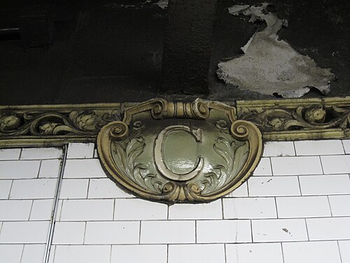 ハインズ&ラファージュ/アトランティック・テラコッタ社によるテラコッタの銘板、1904年
 -
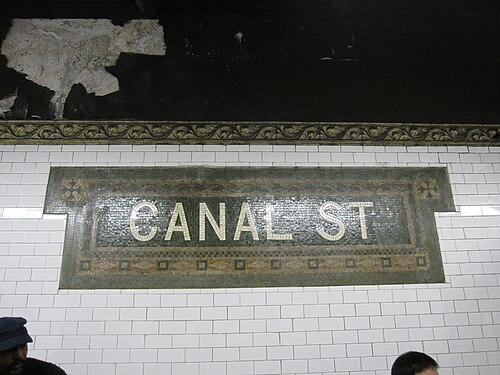 Heins & LaFarge / Manhattan Glass Tile Company による名前の銘板、1904 年
BMTナッソーストリートラインのプラットフォーム
キャナルストリート | ||||||||||||||||||||||||||||||||||||||||||||||||||||||||||||||||||||||||||||||||||
|---|---|---|---|---|---|---|---|---|---|---|---|---|---|---|---|---|---|---|---|---|---|---|---|---|---|---|---|---|---|---|---|---|---|---|---|---|---|---|---|---|---|---|---|---|---|---|---|---|---|---|---|---|---|---|---|---|---|---|---|---|---|---|---|---|---|---|---|---|---|---|---|---|---|---|---|---|---|---|---|---|---|---|
| ニューヨーク市地下鉄駅(高速鉄道) | ||||||||||||||||||||||||||||||||||||||||||||||||||||||||||||||||||||||||||||||||||
 改修後のキャナルストリート | ||||||||||||||||||||||||||||||||||||||||||||||||||||||||||||||||||||||||||||||||||
| ステーション統計 | ||||||||||||||||||||||||||||||||||||||||||||||||||||||||||||||||||||||||||||||||||
| 分割 | B(BMT)[1] | |||||||||||||||||||||||||||||||||||||||||||||||||||||||||||||||||||||||||||||||||
| ライン | BMTナッソーストリート線 | |||||||||||||||||||||||||||||||||||||||||||||||||||||||||||||||||||||||||||||||||
| サービス | J (全回 ) ず (ラッシュアワー、ピーク方向) | |||||||||||||||||||||||||||||||||||||||||||||||||||||||||||||||||||||||||||||||||
| 構造 | 地下 | |||||||||||||||||||||||||||||||||||||||||||||||||||||||||||||||||||||||||||||||||
| プラットフォーム | 島式ホーム2面(うち1面は定期運行) | |||||||||||||||||||||||||||||||||||||||||||||||||||||||||||||||||||||||||||||||||
| トラック | 3(通常運行2) | |||||||||||||||||||||||||||||||||||||||||||||||||||||||||||||||||||||||||||||||||
| その他の情報 | ||||||||||||||||||||||||||||||||||||||||||||||||||||||||||||||||||||||||||||||||||
| オープン | 1913年8月4日[43] | |||||||||||||||||||||||||||||||||||||||||||||||||||||||||||||||||||||||||||||||||
| 再建 | 2004 | |||||||||||||||||||||||||||||||||||||||||||||||||||||||||||||||||||||||||||||||||
| アクセス可能 |  ADA 対応は中二階のみ。プラットフォームは ADA 対応ではありません。 ADA 対応は中二階のみ。プラットフォームは ADA 対応ではありません。 | |||||||||||||||||||||||||||||||||||||||||||||||||||||||||||||||||||||||||||||||||
| 逆 方向 転送 | はい | |||||||||||||||||||||||||||||||||||||||||||||||||||||||||||||||||||||||||||||||||
| ||||||||||||||||||||||||||||||||||||||||||||||||||||||||||||||||||||||||||||||||||
| ||||||||||||||||||||||||||||||||||||||||||||||||||||||||||||||||||||||||||||||||||
| ||||||||||||||||||||||||||||||||||||||||||||||||||||||||||||||||||||||||||||||||||

















BMTナッソーストリート線のカナルストリート駅には3つの線路と2つの島式ホームがありますが、乗客が利用できるのは西側の島式ホームのみです。J線は常時停車し、Z線はラッシュアワー時にピーク方向へ停車します。[174]駅は北はバワリー、南はチェンバーズストリートの間にあります。 [170]
1910年代後半、請負業者は駅の防水工事を行い、線路床の下にレンガの層と厚さ6インチ(15 cm)のコンクリートの層を敷いた。橋梁線のプラットホームを横切る線路床の下には鉛板が設置された。[65] : 29
かつてのキャナル ストリート駅は、南端のバンパー ブロックで内側の線路が行き止まりになっており、2 つのプラットホームの南端がプラットホーム レベルの接続でつながっていることを除けば、典型的な急行駅に似ていました。 [169] 2004 年にナッソー ストリート線が再編された後、東側 (以前の「北行き」) のプラットホームは廃止され、プラットホーム レベルの接続が削除されたため、以前の南行き急行線が南に続くようになりました。最西端 (以前の「南行き」) のプラットホームは引き続き運用されており、両方の線路が直通運転を行っています。南行きの交通は以前の南行き「普通」線路を使用し、北行きの交通は以前の南行き「急行」線路を使用します。以前の北行き普通線路は現在、非収益移動、列車の保管、緊急時のみに使用されており、北行き急行の分岐線路は撤去されています。以前の北行き「普通」線路は、駅の南で以前の南行き「急行」線路 (現在の北行き線路) と合流します。[169]
駅の北と南のトンネル内では、BMTナッソー・ストリート線の4本の線路はそれぞれコンクリートの壁で区切られており、古いIRTトンネルのような柱で区切られていない。これらの壁は、空気がトンネルの側面ではなく通過する列車によって前方に押し出されるため、換気を改善することを目的としていた。2本の内側の線路の間の壁は厚いコンクリートの壁で、不定期に開口部があり、列車が近づいたときに乗務員が脇に寄れるようにしていた。[175]駅の北と南では、2本の西側の線路の間の壁と2本の東側の線路の間の壁に、頻繁に開口部がある。[175] 駅の端から約50フィート (15 m) の中央の壁に開口部があり[176]、そこには狭いプラットフォームがあり、中央の線路で列車の乗務員が列車を行き来するために使用されていた。2004年、東側のプラットフォームが閉鎖される途中だったため、この開口部は新しいタイルで密閉された。
この駅の南側にはチェンバーズストリートからマンハッタン橋の南側の線路に接続するために使われていた未使用の短線路がある。[169] [177]これらの線路は1967年のクリスティーストリート接続の開通とともに切り離され、現在はバンパーブロックで終わっている。[178]

BMTブロードウェイラインのプラットフォーム
キャナルストリート駅の4つのプラットホームは2階建てで、ニューヨーク市地下鉄の路線図では同じ駅として描かれているが[170]、 2つの異なる駅コードがあり、別々の駅として建設された。[70]どちらもBMTブロードウェイ線の一部である。モンタギューストリートトンネルを経由してロウアーマンハッタンとブルックリンに向かう各駅停車はメインラインのプラットホームに停車し、マンハッタンブリッジを経由してブルックリンを行き来する急行列車はブリッジラインのプラットホームに停車する。[170]
ブロードウェイ線の駅の元々のモザイクには、その地域を流れていた運河が描かれており、[179] [180] 1796年のスケッチに見られる。[180]モザイクには、現在のブロードウェイ沿いの運河の近くに住んでいたアメリカ副大統領アーロン・バーの家も描かれているようである。 [179]プラットフォームには、駅がチャイナタウンにあることを反映して、漢字の入ったモザイクがある。赤い壁の銘板のシンボルは「お金」と「幸運」を意味し、「Canal Street」の名前のプレートには「China」と「Town」と読める文字がある。[181]プラットフォームの壁には、「Canal Street」と「Chinatown」という中国語の名前も刻まれている (中国語:堅尼街華埠;ピンイン: Jiān ní jiē huá bù )。
駅には、 1998年にMTAアート&デザインプログラム の一環として設置された、ビン・リーによる「皇后航海1794年2月22日」と題されたアートインスタレーションがある。 [182] [183] このアートインスタレーションには、漢字に触発されたモチーフが含まれている。プラットホームには「良い生活」という漢字に似たティーポットが飾られ、中二階には「アジア」「サイクル」「品質」などの漢字に似たさまざまなシンボルがある。[182]リーのアートは、駅の元々のモザイクの一部を覆っている。[154]
本線ホーム(上層階)
キャナルストリート | |||||||||||||||||||||||||||||||||||||||||||||||||||||||||||||||||||||||||||||||||||
|---|---|---|---|---|---|---|---|---|---|---|---|---|---|---|---|---|---|---|---|---|---|---|---|---|---|---|---|---|---|---|---|---|---|---|---|---|---|---|---|---|---|---|---|---|---|---|---|---|---|---|---|---|---|---|---|---|---|---|---|---|---|---|---|---|---|---|---|---|---|---|---|---|---|---|---|---|---|---|---|---|---|---|---|
| ニューヨーク市地下鉄駅(高速鉄道) | |||||||||||||||||||||||||||||||||||||||||||||||||||||||||||||||||||||||||||||||||||
 本線ホーム | |||||||||||||||||||||||||||||||||||||||||||||||||||||||||||||||||||||||||||||||||||
| ステーション統計 | |||||||||||||||||||||||||||||||||||||||||||||||||||||||||||||||||||||||||||||||||||
| 分割 | B(BMT)[1] | ||||||||||||||||||||||||||||||||||||||||||||||||||||||||||||||||||||||||||||||||||
| ライン | BMTブロードウェイ線 | ||||||||||||||||||||||||||||||||||||||||||||||||||||||||||||||||||||||||||||||||||
| サービス | いいえ (深夜 ) R (深夜を除く) わ (平日のみ) | ||||||||||||||||||||||||||||||||||||||||||||||||||||||||||||||||||||||||||||||||||
| 構造 | 地下 | ||||||||||||||||||||||||||||||||||||||||||||||||||||||||||||||||||||||||||||||||||
| プラットフォーム | 2つのサイドプラットフォーム | ||||||||||||||||||||||||||||||||||||||||||||||||||||||||||||||||||||||||||||||||||
| トラック | 4台(うち2台は旅客用ではない) | ||||||||||||||||||||||||||||||||||||||||||||||||||||||||||||||||||||||||||||||||||
| その他の情報 | |||||||||||||||||||||||||||||||||||||||||||||||||||||||||||||||||||||||||||||||||||
| オープン | 1918年1月5日[184] (ブロードウェイ線) | ||||||||||||||||||||||||||||||||||||||||||||||||||||||||||||||||||||||||||||||||||
| アクセス可能 | ADA 対応は中二階のみ。プラットフォームは ADA 対応ではありません。 | ||||||||||||||||||||||||||||||||||||||||||||||||||||||||||||||||||||||||||||||||||
| 逆 方向 転送 | はい | ||||||||||||||||||||||||||||||||||||||||||||||||||||||||||||||||||||||||||||||||||
| |||||||||||||||||||||||||||||||||||||||||||||||||||||||||||||||||||||||||||||||||||
| |||||||||||||||||||||||||||||||||||||||||||||||||||||||||||||||||||||||||||||||||||
| |||||||||||||||||||||||||||||||||||||||||||||||||||||||||||||||||||||||||||||||||||

.svg/500px-BSicon_uPSTR(R).svg.png)
.svg/500px-BSicon_uPSTR(L).svg.png)





本線のキャナルストリート駅には4本の線路と2つの側線がある。[169]この駅に停車する唯一の外側の各駅停車線は、モンタギューストリートトンネルを経由して直通運転を行っている。R線は深夜を除いて常にこの駅に停車し、[185]深夜にはN線に置き換えられる。[186] W線は平日にこの駅に停車する。[187]駅は北はプリンスストリート、南はシティホールの間にある。 [170]
中央線はこれまで一度も営業運転されたことがなく、市庁舎の使われていない下層階から始まり、北にここまで走り、約3分の2の地点でバンパーブロックで行き止まりとなっている。中央線は停車場として使用できるが、この用途は完全に不要となり、代わりに近くの市庁舎下層階が停車場として使用されている。[169]
ブリッジラインホーム(下層階)
キャナルストリート | |||||||||||||||||||||||||||||||||||||||||||||||||||||||||||||||||||||||||||||||||||||||||||||||||||||||||||||||||||||||
|---|---|---|---|---|---|---|---|---|---|---|---|---|---|---|---|---|---|---|---|---|---|---|---|---|---|---|---|---|---|---|---|---|---|---|---|---|---|---|---|---|---|---|---|---|---|---|---|---|---|---|---|---|---|---|---|---|---|---|---|---|---|---|---|---|---|---|---|---|---|---|---|---|---|---|---|---|---|---|---|---|---|---|---|---|---|---|---|---|---|---|---|---|---|---|---|---|---|---|---|---|---|---|---|---|---|---|---|---|---|---|---|---|---|---|---|---|---|---|---|
| ニューヨーク市地下鉄駅(高速鉄道) | |||||||||||||||||||||||||||||||||||||||||||||||||||||||||||||||||||||||||||||||||||||||||||||||||||||||||||||||||||||||
 ブリッジラインプラットフォーム | |||||||||||||||||||||||||||||||||||||||||||||||||||||||||||||||||||||||||||||||||||||||||||||||||||||||||||||||||||||||
| ステーション統計 | |||||||||||||||||||||||||||||||||||||||||||||||||||||||||||||||||||||||||||||||||||||||||||||||||||||||||||||||||||||||
| 分割 | B(BMT)[1] | ||||||||||||||||||||||||||||||||||||||||||||||||||||||||||||||||||||||||||||||||||||||||||||||||||||||||||||||||||||||
| ライン | BMTブロードウェイ線 | ||||||||||||||||||||||||||||||||||||||||||||||||||||||||||||||||||||||||||||||||||||||||||||||||||||||||||||||||||||||
| サービス | いいえ (深夜を除く ) 質問 (全回) | ||||||||||||||||||||||||||||||||||||||||||||||||||||||||||||||||||||||||||||||||||||||||||||||||||||||||||||||||||||||
| 構造 | 地下 | ||||||||||||||||||||||||||||||||||||||||||||||||||||||||||||||||||||||||||||||||||||||||||||||||||||||||||||||||||||||
| プラットフォーム | 2つのサイドプラットフォーム | ||||||||||||||||||||||||||||||||||||||||||||||||||||||||||||||||||||||||||||||||||||||||||||||||||||||||||||||||||||||
| トラック | 2 | ||||||||||||||||||||||||||||||||||||||||||||||||||||||||||||||||||||||||||||||||||||||||||||||||||||||||||||||||||||||
| その他の情報 | |||||||||||||||||||||||||||||||||||||||||||||||||||||||||||||||||||||||||||||||||||||||||||||||||||||||||||||||||||||||
| オープン | 1917年9月4日[188](マンハッタン橋) | ||||||||||||||||||||||||||||||||||||||||||||||||||||||||||||||||||||||||||||||||||||||||||||||||||||||||||||||||||||||
| 再建 | 2001 | ||||||||||||||||||||||||||||||||||||||||||||||||||||||||||||||||||||||||||||||||||||||||||||||||||||||||||||||||||||||
| アクセス可能 | ADA 対応は中二階のみ。プラットフォームは ADA 対応ではありません。 | ||||||||||||||||||||||||||||||||||||||||||||||||||||||||||||||||||||||||||||||||||||||||||||||||||||||||||||||||||||||
| 逆 方向 転送 | はい | ||||||||||||||||||||||||||||||||||||||||||||||||||||||||||||||||||||||||||||||||||||||||||||||||||||||||||||||||||||||
| |||||||||||||||||||||||||||||||||||||||||||||||||||||||||||||||||||||||||||||||||||||||||||||||||||||||||||||||||||||||
| |||||||||||||||||||||||||||||||||||||||||||||||||||||||||||||||||||||||||||||||||||||||||||||||||||||||||||||||||||||||
| |||||||||||||||||||||||||||||||||||||||||||||||||||||||||||||||||||||||||||||||||||||||||||||||||||||||||||||||||||||||
| |||||||||||||||||||||||||||||||||||||||||||||||||||||||||||||||||||||||||||||||||||||||||||||||||||||||||||||||||||||||














マンハッタン橋ルートのキャナルストリート駅には2本の線路と2つの側線プラットフォームがある。[ 169 ]開業当時、この駅はブロードウェイと呼ばれていた。[70] N線は夜間以外はこの駅に停車し、夜間は本線プラットフォームに停車する。 [186 ]一方、Q線は常時この駅に停車する。[189]この駅の西側(線路北側)では、N線は平日は急行、週末は各駅停車となる。[186]一方、Q線は日中は急行、夜間は各駅停車となる。[189]西側の次の停車駅は、各駅停車の場合はプリンスストリート、急行の場合は14番街-ユニオンスクエアである。東側(線路南側)の次の停車駅は、Q線の場合はディカルブアベニュー、N線の場合はアトランティックアベニュー-バークレイズセンターである。[170]
技術的にはBMTブロードウェイ線に位置していたが、もともと本線とは別の駅であり、連絡通路でのみつながっていた。[56]この駅の元々のタイルには単に「ブロードウェイ」と書かれており、タイル名の下の壁に「キャナルストリート」と書かれた小さな木製または金属製の看板が取り付けられていた。
駅の西側では、橋の線路が北にカーブし、各駅停車ホームから線路の間を上り、急行線を形成している。[169]トンネルは分岐を過ぎて本線まで真っ直ぐ続く。駅の西端から西に伸びるベルマウスは当初の計画から備わったもので、約100フィート (30 m) にわたって伸びている。線路の1つには倉庫がある。
駅の東側では、線路はマンハッタン橋の南側を横切りブルックリンに入る。橋の北側の線路に続く使われていない線路があり、これらのプラットホームから列車が通っていた。これらの線路は1967年のクリスティー・ストリート・コネクションの開通とともに切り離され、現在はレールやその他のインフラはない。[169]
アートワークの詳細
-
 本線ホームモザイク
 -
 ブリッジラインプラットフォームモザイク
 -
 名前石板モザイク
 -
 ブリッジラインのプラットフォームに続く通路に、ビン・リーによる「皇后の航海 1794年2月22日(1998年)」と題された常設のアートインスタレーションが設置されている。
参考文献
- ^ a b c d e "Glossary". Second Avenue Subway Supplemental Draft Environmental Impact Statement (SDEIS) (PDF). Vol. 1. Metropolitan Transportation Authority. March 4, 2003. pp. 1–2. Archived from the original (PDF) on February 26, 2021. Retrieved January 1, 2021.
- ^ "Manhattan Bus Map" (PDF). Metropolitan Transportation Authority. July 2019. Retrieved December 1, 2020.
- ^ a b "City Subways Add 3 Transfer Points". The New York Times. January 16, 1978. p. B2. ISSN 0362-4331. Archived from the original on July 22, 2018. Retrieved July 22, 2018.
- ^ a b "Annual Subway Ridership (2018–2023)". Metropolitan Transportation Authority. 2023. Retrieved April 20, 2024.
- ^ a b c d e f g h i j k l m n o Walker, James Blaine (1918). Fifty Years of Rapid Transit — 1864 to 1917. New York, N.Y.: Law Printing. Retrieved November 6, 2016.
- ^ a b c d "Interborough Rapid Transit System, Underground Interior" (PDF). New York City Landmarks Preservation Commission. October 23, 1979. Archived (PDF) from the original on September 21, 2020. Retrieved November 19, 2019.
- ^ a b Report of the Board of Rapid Transit Railroad Commissioners for the City of New York For The Year Ending December 31, 1904 Accompanied By Reports of the Chief Engineer and of the Auditor. Board of Rapid Transit Railroad Commissioners. 1905. pp. 229–236.
- ^ a b "Tunnel Contractor's Struggle With City Quicksands; Latest Difficulty Comes in the Last Stages of the Excavation in the Old Canal Street Swamp". The New York Times. October 5, 1902. ISSN 0362-4331. Archived from the original on December 16, 2021. Retrieved January 6, 2021.
- ^ a b c d e Scott, Charles (1978). "Design and Construction of the IRT: Civil Engineering" (PDF). Historic American Engineering Record. pp. 208–282 (PDF pp. 209–283). Archived (PDF) from the original on January 17, 2021. Retrieved December 20, 2020.
 This article incorporates text from this source, which is in the public domain.
{{cite web}}: CS1 maint: postscript (link) - ^ a b "Progress in the Subway; Only Two Untouched Portions of the Line Left". The New York Times. August 10, 1902. ISSN 0362-4331. Archived from the original on September 18, 2023. Retrieved May 19, 2023.
- ^ "The Rapid Transit Subway, New York". Scientific American. Vol. LXXXVII, no. 13. September 27, 1902. p. 202. ProQuest 126817124.
- ^ "The Subway's Main Line; Only Eighteen Blocks Below 104th Street Remain Unopened. Two of the Sections Are to be Finished in a Year and the Others Will Not Be Far Behindhand". The New York Times. February 2, 1902. ISSN 0362-4331. Archived from the original on May 10, 2022. Retrieved May 25, 2023.
- ^ Ruhl, Arthur (October 1902). "Building New York's Subway". Century Illustrated Magazine. Vol. LXIV, no. 6. p. 898. ProQuest 125503986.
- ^ "Unsightly Streets Over the Subway; Contractors Leave Obstructions and Litter at Many Points Where Tunnel Work Is Done". The New York Times. August 16, 1903. ISSN 0362-4331. Archived from the original on September 18, 2023. Retrieved May 19, 2023.
- ^ "First of Subway Tests; West Side Experimental Trains to be Run by Jan. 1 Broadway Tunnel Tracks Laid, Except on Three Little Sections, to 104th Street – Power House Delays". The New York Times. November 14, 1903. ISSN 0362-4331. Archived from the original on May 5, 2022. Retrieved May 10, 2022.
- ^ a b c "Our Subway Open: 150,000 Try It; Mayor McClellan Runs the First Official Train". The New York Times. October 28, 1904. p. 1. ISSN 0362-4331. Archived from the original on December 13, 2021. Retrieved April 21, 2020.
- ^ "Our First Subway Completed At Last — Opening of the Van Cortlandt Extension Finishes System Begun in 1900 — The Job Cost $60,000,000 — A Twenty-Mile Ride from Brooklyn to 242d Street for a Nickel Is Possible Now". The New York Times. August 2, 1908. p. 10. Archived from the original on May 30, 2020. Retrieved November 6, 2016.
- ^ Herries, William (1916). Brooklyn Daily Eagle Almanac. The Brooklyn Daily Eagle. p. 119. Archived from the original on May 11, 2021. Retrieved December 25, 2020.
- ^ a b Hood, Clifton (1978). "The Impact of the IRT in New York City" (PDF). Historic American Engineering Record. pp. 146–207 (PDF pp. 147–208). Archived (PDF) from the original on January 17, 2021. Retrieved December 20, 2020. This article incorporates text from this source, which is in the public domain.
{{cite web}}: CS1 maint: postscript (link) - ^ a b Report of the Public Service Commission for the First District of the State of New York For The Year Ending December 31, 1910. Public Service Commission. 1911. Archived from the original on February 5, 2023. Retrieved January 7, 2021.
- ^ State of New York Transit Commission Third Annual Report for the Calendar Year 1923. New York State Transit Commission. 1924. p. 501. Archived from the original on May 30, 2023. Retrieved May 30, 2023.
- ^ "A New Subway Line for New York City". Engineering News. 63 (10). March 10, 1910. Archived from the original on July 5, 2012. Retrieved December 25, 2020.
- ^ a b "Subway Contracts Solemnly Signed; Cheers at the Ceremonial Function When McCall Gets Willcox to Attest" (PDF). The New York Times. March 20, 1913. ISSN 0362-4331. Archived (PDF) from the original on May 4, 2022. Retrieved January 11, 2018.
- ^ "Dual Subway Stations: Protesting Owners Should File Petitions for Changes". New-York Tribune. May 4, 1913. p. C8. ISSN 1941-0646. ProQuest 575088610.
- ^ "Coming Back to Dry Goods Centre; Rentals Showing Improvement in Broadway District Below Canal Street". The New York Times. January 11, 1914. ISSN 0362-4331. Archived from the original on May 17, 2023. Retrieved May 17, 2023.
- ^ "Open New Subway Lines to Traffic; Called a Triumph — Great H System Put in Operation Marks an Era in Railroad Construction — No Hitch in the Plans — But Public Gropes Blindly to Find the Way in Maze of New Stations — Thousands Go Astray — Leaders in City's Life Hail Accomplishment of Great Task at Meeting at the Astor" (PDF). The New York Times. August 2, 1918. p. 1. Archived (PDF) from the original on February 21, 2021. Retrieved November 6, 2016.
- ^ "To Join All Four Bridges by L Road and Subways". The Brooklyn Daily Eagle. November 21, 1902. p. 1. Archived from the original on September 18, 2023. Retrieved May 19, 2023.
- ^ "Best's Bridge Scheme Approved by Nichols". The Brooklyn Daily Eagle. March 9, 1904. p. 22. Archived from the original on September 18, 2023. Retrieved May 19, 2023.
- ^ "Would Operate Local Cars Across Manhattan". Brooklyn Times Union. March 9, 1904. p. 10. Retrieved May 19, 2023.
- ^ a b "Subway Loop Approved; Will Have Four Tracks". The New York Times. January 26, 1907. p. 16. ISSN 0362-4331. Archived from the original on July 18, 2018. Retrieved August 1, 2019.
- ^ "Subway Loop Assured: Four-track Bridge Link Estimate Board Approves—cost, $5,000,000—ready in 2 1–2 Years". New-York Tribune. January 26, 1907. p. 1. ISSN 1941-0646. ProQuest 571760875.
- ^ Stevenson, Frederick Boyd (July 13, 1913). "Colonel Williams' View of Centre Street Loop". The Brooklyn Daily Eagle. p. 23. Archived from the original on October 2, 2018. Retrieved October 2, 2018.
- ^ "Centre Street Subway Loop and Manhattan Bridge Nearing Completion With No Traffic Arrangements in Sight". The Brooklyn Daily Eagle. October 15, 1908. p. 21. Archived from the original on May 16, 2023. Retrieved May 16, 2023 – via Newspapers.com.
- ^ a b Comptroller's Monthly Report. 1916. p. 2-PA147-IA1. Archived from the original on May 16, 2023. Retrieved May 16, 2023.
- ^ "Expect Many Bidders". The Brooklyn Citizen. March 23, 1907. p. 12. Archived from the original on May 16, 2023. Retrieved May 16, 2023 – via Newspapers.com.
- ^ "Bids for Subway Loop". New-York Tribune. March 13, 1907. p. 5. Archived from the original on May 16, 2023. Retrieved May 16, 2023 – via Newspapers.com.
- ^ "Courts in Danger: Building Crumbles $2,50,000 Needed to Repair Centre Street Structure". New-York Tribune. November 2, 1909. p. 5. ISSN 1941-0646. ProQuest 572298236.
- ^ http://www.columbia.edu/~brennan/abandoned/Canal.platf.jpg Archived March 3, 2016, at the Wayback Machine From the Abandoned Stations website: A Public Service Commission photo from 1909 shows the east platform with non-tiled steel columns. The view is looking south, showing the wall between the center tracks. The stepped structure at the base of wall near the image center is part of the bridge over the projected Canal St subway, not even begun at the time. The station looks completed, about four years before it opened. There is a rough strip near the platform edge. Track was to be installed by the operating company.
- ^ "Asks for Subway Loop: B. R. T. Would Bring "L" Trains Close to Brooklyn Bridge P. S. C. Considering Offer Company Says Bridge Crush Would Be Relieved and Transit Improved". New-York Tribune. April 13, 1910. p. 8. ISSN 1941-0646. ProQuest 572372770.
- ^ "Subway Bridge Loop Nearing Completion; Only That Part Under the New Municipal Building Yet to be Built". The New York Times. April 13, 1910. ISSN 0362-4331. Archived from the original on May 12, 2023. Retrieved May 12, 2023.
- ^ a b "To Open Centre St. Loop; B.R.T. Authorized to Begin Operations – May Be Ready by July 1". The New York Times. March 29, 1913. ISSN 0362-4331. Archived from the original on May 12, 2023. Retrieved May 12, 2023.
- ^ "Subway Construction". The Wall Street Journal. March 29, 1913. p. 2. ISSN 0099-9660. ProQuest 129417638.
- ^ a b c "Passenger Killed On Loop's First Day ; Printer, Impatient at Delay in New Bridge Subway, Tries to Walk the Track". The New York Times. August 5, 1913. p. 2. ISSN 0362-4331. Archived from the original on December 17, 2021. Retrieved August 1, 2019.
- ^ "Brooklyn Crowds Jam New $13,000,000 Loop: One-fourth of Old Bridge Traffic Diverted at Night, but Crush is Terrific". New-York Tribune. August 5, 1913. p. 14. ISSN 1941-0646. ProQuest 575116848.
- ^ "Interborough Has New Railroad Plan; Offers to Build and Equip a Line Between Flatbush Avenue and Canal Street, Manhattan". The New York Times. May 27, 1908. ISSN 0362-4331. Archived from the original on May 7, 2023. Retrieved May 16, 2023.
- ^ "May Rival B. R. T.: Interborough's Offer Willing to Build Subway in Brooklyn and Give Five-cent Fare Advantage to Brooklynites Metz Opposed to Monopoly B. R. T. Won't Make Proposal". New-York Tribune. May 27, 1908. p. 1. ISSN 1941-0646. ProQuest 572083800.
- ^ "Invasion by B. R. T.: May Operate Here Seeks Manhattan Extension by "L" and Subways". New-York Tribune. November 25, 1909. p. 4. ISSN 1941-0646. ProQuest 572307252.
- ^ "B.R.T. Would Now Invade Manhattan; Company Has Extension Plans to Connect the North River and Coney Island". The New York Times. November 25, 1909. ISSN 0362-4331. Archived from the original on September 18, 2023. Retrieved May 20, 2023.
- ^ a b c d "Canal St. Subway is One-third Done". The Standard Union. August 22, 1915. p. 16. Archived from the original on May 15, 2023. Retrieved May 15, 2023 – via Newspapers.com.
- ^ a b "Morgan Firm Waits on Subway Debate; Letter Setting a Time Limit on Financing Withdrawn for the Present". The New York Times. May 14, 1912. ISSN 0362-4331. Archived from the original on May 15, 2023. Retrieved May 15, 2023.
- ^ "Subways Voted by P. S. Board; Contracts Out". The Brooklyn Daily Eagle. March 4, 1913. pp. 1, 5. Archived from the original on May 18, 2023. Retrieved May 18, 2023.
- ^ "B.R.T. Asks Approval of $65,000,000 Issue; Its Subsidiary Will Put Out Bonds and Mortgage Not to Exceed $100,000,000 for Subways". The New York Times. January 11, 1913. ISSN 0362-4331. Archived from the original on May 18, 2023. Retrieved May 18, 2023.
- ^ "Brooklyn Rapid Transit". The Wall Street Journal. October 10, 1913. p. 2. ISSN 0099-9660. ProQuest 129417379.
- ^ "New Subways Done by Next Summer; Lexington Avenue and Broadway Lines' Construction Nears Completion". The New York Times. July 16, 1916. ISSN 0362-4331. Archived from the original on May 30, 2023. Retrieved May 30, 2023.
- ^ "Canal Street Subway Plans". The New York Times. February 8, 1914. p. 78. Archived from the original on May 15, 2023. Retrieved May 15, 2023 – via Newspapers.com.
- ^ a b "Action on Two More Subway Contracts". The Brooklyn Daily Eagle. April 14, 1914. p. 3. Archived from the original on May 18, 2023. Retrieved May 18, 2023.
- ^ "New York Subway Amount is $1,815,000". The Christian Science Monitor. May 13, 1914. p. 7. ProQuest 509092904.
- ^ "Canal Street Subway; Low Lying Ground Adds to Cost of the Work". The New York Times. May 17, 1914. ISSN 0362-4331. Archived from the original on May 15, 2023. Retrieved May 15, 2023.
- ^ "$21,000,000 for Subways; Contracts Signed for East River Tunnels and Other Work". The New York Times. July 17, 1914. ISSN 0362-4331. Archived from the original on May 2, 2023. Retrieved May 17, 2023.
- ^ "$2,000,000 A Month Going Into Subways; Work Well Under Way and All Contracts Soon Will Have Been Let". The New York Times. November 30, 1914. ISSN 0362-4331. Archived from the original on May 15, 2023. Retrieved May 15, 2023.
- ^ "Tried to Hold Up Routes for Subway". The Brooklyn Daily Eagle. October 30, 1914. p. 9. Archived from the original on May 15, 2023. Retrieved May 15, 2023 – via Newspapers.com.
- ^ a b c d "Old Canal Hinders Subway Builders". The Sun. March 22, 1914. p. 20. Archived from the original on May 18, 2023. Retrieved May 17, 2023 – via Newspapers.com.
- ^ a b c d e Bell, Jefferson G. (May 13, 1928). "Collect Pond Remains to Plague New York; Filled in a Century Ago, Its Watery Depths and Its Spreading Marshes Halt the Construction of Large Buildings in the Civic Centre Sixty Feet of Filled Earth. A Station Surrounded by Water". The New York Times. ISSN 0362-4331. Archived from the original on May 21, 2023. Retrieved May 21, 2023.
- ^ "Subway to Open Two New Stations; Broadway Line of B.R.T. Will Extend to Lexington Av. and 60th St. Tomorrow". The New York Times. August 31, 1919. ISSN 0362-4331. Archived from the original on June 14, 2018. Retrieved May 18, 2023.
- ^ a b c d e Freeman, Milton H. (1925). "Stopping Leaks in the Brooklyn Rapid Transit Subway at the Broadway – Canal Street Station". Proceedings ... constitution and by-laws. Vol. 23. Brooklyn Engineers' Club. hdl:2027/uc1.b2977862. Retrieved May 17, 2023 – via HathiTrust.
- ^ "Canal Street Subway; Completion of This Link at Once Will Save City Large Amount". The New York Times. January 23, 1916. ISSN 0362-4331. Archived from the original on May 15, 2023. Retrieved May 15, 2023.
- ^ a b "B.R.T. Subway Trains Up Broadway Soon; Finishing Contracts Let and Traffic May Reach 14th Street by Spring". The New York Times. October 29, 1916. ISSN 0362-4331. Archived from the original on May 15, 2023. Retrieved May 17, 2023.
- ^ "Broadway Subway Opened To Coney By Special Train. Brooklynites Try New Manhattan Link From Canal St. to Union Square. Go Via Fourth Ave. Tube". The Brooklyn Daily Eagle. September 4, 1917. Retrieved May 31, 2019.
- ^ "Open First Section of Broadway Line; Train Carrying 1,000 Passengers Runs from Fourteenth Street to Coney Island". The New York Times. September 5, 1917. ISSN 0362-4331. Archived from the original on June 12, 2018. Retrieved December 27, 2020.
- ^ a b c "Broadway Subway Opens". The Brooklyn Citizen. September 4, 1917. p. 1. Archived from the original on May 18, 2023. Retrieved May 18, 2023.
- ^ "Stations for New Subway; Tentative Plans Announced – Few Express Stops, Permitting High Speed". The New York Times. July 21, 1909. ISSN 0362-4331. Archived from the original on May 16, 2023. Retrieved May 16, 2023.
- ^ "Stations on New Line: Tentative List on Broadway-lexington Avenue Subway Announced". New-York Tribune. July 21, 1909. p. 12. ISSN 1941-0646. ProQuest 572268569.
- ^ "Subway Contract Awarded". The Brooklyn Daily Eagle. January 24, 1912. p. 1. Archived from the original on May 15, 2023. Retrieved May 15, 2023 – via Newspapers.com.
- ^ "Willcox Defends Wagner Subways Bill". The Sun. March 23, 1912. p. 5. Archived from the original on May 15, 2023. Retrieved May 15, 2023 – via Newspapers.com.
- ^ "Worried by Fight Over Subway Bill; City Officials Fear Defeat of Amendments May Destroy Plans for Traction Relief". The New York Times. March 23, 1912. ISSN 0362-4331. Archived from the original on May 15, 2023. Retrieved May 15, 2023.
- ^ "Approve Mortgages for New Subways; $300,000,000 for Interborough, $100,000,000 for the Other, Maltbie Alone Dissenting". The New York Times. March 21, 1913. ISSN 0362-4331. Archived from the original on May 17, 2023. Retrieved May 17, 2023.
- ^ "Brooklyn Will Gain Most By Subway Construction". The Brooklyn Daily Eagle. April 20, 1913. p. 40. Archived from the original on May 17, 2023. Retrieved May 17, 2023 – via Newspapers.com.
- ^ "New Subway Work Going Ahead Fast; Lexington Avenue Furthest Advanced – City Has $81,000,000 of Contracts Under Way". The New York Times. June 30, 1913. ISSN 0362-4331. Archived from the original on May 17, 2023. Retrieved May 17, 2023.
- ^ a b "Manhattan to Coney by Tube Next Year". The Brooklyn Daily Eagle. February 22, 1916. p. 4. Archived from the original on May 3, 2023. Retrieved April 30, 2023.
- ^ a b "New Subway Trains to Run Within Year; The Times Square Section Will Be Completed, It Is Believed, by July, 1917". The New York Times. February 23, 1916. ISSN 0362-4331. Archived from the original on May 3, 2023. Retrieved April 30, 2023.
- ^ "Urge New Station for Shoppers' Use". The Standard Union. March 12, 1916. p. 20. Archived from the original on May 3, 2023. Retrieved April 30, 2023.
- ^ "Open New Subway To Times Square; Brooklyn Directly Connected with Wholesale and Shopping Districts of New York. Nickel Zone Is Extended. First Train in Broadway Tube Makes Run from Rector Street in 17 Minutes. Cost About $20,000,000 Rapid Transit from Downtown to Hotel and Theatre Sections Expected to Affect Surface Lines. Increases Five-Cent Zone. First Trip to Times Square. Benefits to Brooklyn" (PDF). The New York Times. January 6, 1918. ISSN 0362-4331. Archived (PDF) from the original on August 31, 2021. Retrieved November 5, 2016.
- ^ "New Broadway Subway Opened From 42d to Rector Street: First Train Carries B. R. T. and City Officials, With Representatives of Civic Organizations—Line Then Turned Over to Public". New-York Tribune. January 6, 1918. p. 17. ProQuest 575840136.
- ^ a b "To Stop Subway Leaks.; Service Board Takes Up Matter of Deluge at Canal Street Station". The New York Times. April 13, 1918. ISSN 0362-4331. Archived from the original on May 16, 2023. Retrieved May 16, 2023.
- ^ "Leaks in Subway Puzzle to P.S.C." The Brooklyn Citizen. April 14, 1918. p. 23. Archived from the original on May 18, 2023. Retrieved May 18, 2023.
- ^ a b "Subway Leaks Remedied; Cracks in Waterproofing Caused Canal Street Station Floods". The New York Times. April 27, 1919. p. 25. ISSN 0362-4331. Archived from the original on May 16, 2023. Retrieved May 16, 2023.
- ^ a b c "Leak at Subway Station". Poughkeepsie Eagle-News. May 5, 1919. p. 7. Archived from the original on May 18, 2023. Retrieved May 18, 2023 – via Newspapers.com.
- ^ a b "Tube Leak Halts Full Service". Brooklyn Times Union. October 25, 1918. p. 2. Archived from the original on May 16, 2023. Retrieved May 16, 2023 – via Newspapers.com.
- ^ "A Subway Through a Swamp". The Brooklyn Daily Eagle. October 26, 1918. p. 6. Archived from the original on May 16, 2023. Retrieved May 16, 2023 – via Newspapers.com.
- ^ "Broadway Board of Trade Seeking Many Improvements". The Chat. May 10, 1919. p. 23. Archived from the original on May 19, 2023. Retrieved May 19, 2023.
- ^ "Color Signs Adopted as Guides in Subways; Blue and White for I.R.T. and White and Green for B.R. T. Stations". The New York Times. June 10, 1922. ISSN 0362-4331. Archived from the original on August 14, 2023. Retrieved May 13, 2023.
- ^ "B. R. T. to End Jam on Sundays On Coney Lines: Receiver Garrison, After a Conference With Harkness, Agrees to Provide Relief Without an Order City Bus Lines Attacked Estimate Board Again Refuses to Aid Commission on Staten Island Tunnels". New-York Tribune. June 10, 1922. p. 5. ISSN 1941-0646. ProQuest 576624795.
- ^ "33d Street to Be I.R.T. Express Stop; Reconstruction One of Many Station Improvements Ordered by Commission". The New York Times. December 17, 1922. ISSN 0362-4331. Archived from the original on June 21, 2022. Retrieved June 21, 2022.
- ^ "$4,000,000 in Construction on I. R. T. Ordered: 33d St. on East Side Subway Will Be Express Stop; Local Stations to Have 10-Car Train Capacity Aim to Speed Service Improvements Will Relieve Congestion Along Both Routes. Board Believes". New-York Tribune. December 18, 1922. p. 22. ProQuest 573974563.
- ^ "Express Stop Plan Opposed by I.R.T.; Officials Say Money Is Not Available for Change at 33d Street Station". The New York Times. September 7, 1923. ISSN 0362-4331. Archived from the original on June 21, 2022. Retrieved June 21, 2022.
- ^ "I. R. T. Wins Delay At Subway Platform Extension Hearing: Transit Commission Head Tells Meeting Widening West Side Stations Would Increase Capacity 25 P. C". New-York Tribune. September 7, 1923. p. 6. ProQuest 1237290874.
- ^ "Bids for B.M.T. Stations; Platforms South of Fourteenth Street to Be Lengthened". The New York Times. July 8, 1926. ISSN 0362-4331. Archived from the original on April 28, 2023. Retrieved April 28, 2023.
- ^ "B.M.T. to Operate Eight-car Trains; Platforms in Forty Stations Are Lengthened, Increasing Capacity 33 1–3%". The New York Times. August 2, 1927. ISSN 0362-4331. Archived from the original on May 12, 2023. Retrieved May 12, 2023.
- ^ "B. M, T. Station Lengthening Is Nearly Finished: 76 Platforms Are Extended 3,186 Feet to Make Room for 126.000 Additional Passengers in Rush Hours City Carried Out Work I.R.T. Changes Planned, but That Company Refuses to Pay Its Share of Costs". New-York Tribune. August 2, 1927. p. 32. ISSN 1941-0646. ProQuest 1113704092.
- ^ "I. R. T. Ordered to Buy 289 Cars For Subway Rush-Hour Service". New York Herald Tribune. May 1, 1930. p. 1. ISSN 1941-0646. ProQuest 1113173064.
- ^ "Ready With Plans on I.R.T. Platforms; Transportation Board to Lay All Details on Lengthening Before Commission Friday". The New York Times. December 5, 1927. ISSN 0362-4331. Archived from the original on September 18, 2023. Retrieved May 20, 2023.
- ^ "I. R. T. Platform Extension Plan Is Completed: City Board of Transportation to Submit Contract Forms to Transit Commission; Lengthen All Local Trains May Abandon 2 Stations Worth and 18th Sts. Show Falling Patronage; B.M.T. Has Finished Similar Work". New York Herald Tribune. December 6, 1927. p. 17. ISSN 1941-0646. ProQuest 1132104986.
- ^ "Order I.R.T. To Build Ten-car Platforms; Transit Commissioners Direct Company to Begin Work at Four Local Stations". The New York Times. January 1, 1928. ISSN 0362-4331. Archived from the original on September 18, 2023. Retrieved May 20, 2023.
- ^ a b "Moves to Compel I.R.T. Improvements; Transit Board Gives Order to Road to Lengthen Two Station Platforms". The New York Times. July 7, 1929. ISSN 0362-4331. Archived from the original on September 18, 2023. Retrieved May 20, 2023.
- ^ "Hedley and Menden Defend 'Keying by'; Tell Board That Enforcement of Its Order Would Cause Serious Rush-Hour Delay". The New York Times. July 11, 1929. ISSN 0362-4331. Archived from the original on September 18, 2023. Retrieved May 26, 2023.
- ^ "Plans to Order I.R.T. To Get 239 New Cars; Transit Board to Demand That Equipment Be Ready in 15 Months". The New York Times. September 21, 1929. ISSN 0362-4331. Archived from the original on March 31, 2018. Retrieved May 20, 2023.
- ^ "Asks Writ to Make I.R.T. Buy New Cars; Transit Board Also Aims to Force Company to Abide by Its Platform-Extension Ruling". The New York Times. September 5, 1930. ISSN 0362-4331. Archived from the original on September 18, 2023. Retrieved May 20, 2023.
- ^ a b c "14th St. Tube Eases Jams; Transit Board Reports Drop in Transfers Issued at Canal Street". The New York Times. August 17, 1928. ISSN 0362-4331. Archived from the original on April 28, 2023. Retrieved April 28, 2023.
- ^ "New York City Traffic Has Phenomenal Growth". The Wall Street Journal. August 17, 1918. p. 2. Archived from the original on May 18, 2023. Retrieved May 18, 2023.
- ^ "Brooklyn Rapid Transit". Railway Age. Vol. 65, no. 9. August 30, 1918. p. 371. ProQuest 883986031.
- ^ "Congestion on B.R.T. Subway Rivals H Lines". New-York Tribune. August 19, 1918. p. 12. Archived from the original on September 18, 2023. Retrieved May 18, 2023.
- ^ "Canal St. Subway, Nerve Spot, Chaos". The Brooklyn Daily Eagle. January 23, 1918. p. 4. Archived from the original on May 19, 2023. Retrieved May 19, 2023.
- ^ "Williams' Letter Angers Broadway Merchants' Club". The Chat. February 23, 1918. p. 1. Archived from the original on September 18, 2023. Retrieved May 18, 2023.
- ^ "Commission Sued on B.R.T. Contract". The Standard Union. December 10, 1918. p. 3. Archived from the original on May 19, 2023. Retrieved May 19, 2023.
- ^ "$26,500,000 for New Subway Construction". The Standard Union. December 5, 1918. pp. 1, 8. Archived from the original on May 18, 2023. Retrieved May 18, 2023.
- ^ "N. H. Levi Commends Mayor in Broadway Board Report". The Chat. February 9, 1918. pp. 1, 4. Archived from the original on May 18, 2023. Retrieved May 18, 2023.
- ^ "Magistrate Dodd on Work of Courts". The Standard Union. February 2, 1918. p. 10. Archived from the original on May 19, 2023. Retrieved May 19, 2023.
- ^ "B.R.T. Gives Promise of Better Service; More Platform Men to be Put On at Stations Where Crowding Creates Danger". The New York Times. February 17, 1918. ISSN 0362-4331. Archived from the original on May 18, 2023. Retrieved May 18, 2023.
- ^ "New B.R.T. Transfer Rule; Must Use Street In Changing at Canal During Rush Hours". The New York Times. June 5, 1920. ISSN 0362-4331. Archived from the original on April 28, 2023. Retrieved April 28, 2023.
- ^ "B.R.T. Announces New Traffic Rules for Canal St. Station". Times Union. June 4, 1920. p. 14. Archived from the original on April 28, 2023. Retrieved April 28, 2023.
- ^ "Relief for Canal Street; Transit Board Orders Plans to Ease Subway Congestion There". The New York Times. June 14, 1922. ISSN 0362-4331. Archived from the original on September 18, 2023. Retrieved May 21, 2023.
- ^ "Want Station Between City Hall and Canal St". New-York Tribune. July 29, 1923. p. C1. ISSN 1941-0646. ProQuest 1114728212.
- ^ "B.-M.T. Puts Wreck Peril Up to Hylan: Blame for Any Disaster at Canal Street Will Be Mayor's, Says Dahl, in Attack on Transit Delay Also Culpable in Wreck at Brighton Wooden Cars Ascribed to City's Tactics; Motorman of Train Is Held". The New York Herald, New York Tribune. August 7, 1924. p. 1. ISSN 1941-0646. ProQuest 1113021692.
- ^ "Dahl and Mayor Blame Each Other in Wreck Reports; B.M.T. Head Lays Continued Use of Wooden Cars to City's Transit Policies". The New York Times. August 7, 1924. ISSN 0362-4331. Archived from the original on September 18, 2023. Retrieved May 21, 2023.
- ^ "Agree on Subway for 14th St. Line; Executing of Compact by Transit Board and B.M.T. Is Arranged". The New York Times. February 26, 1925. ISSN 0362-4331. Archived from the original on September 18, 2023. Retrieved May 21, 2023.
- ^ "Communities in Gala Attire Awaiting 'First Train' in New Subway". The Chat. July 14, 1928. p. 37. Archived from the original on April 28, 2023. Retrieved April 28, 2023.
- ^ a b "Relief From New Tube Fails to Materialize in Bushwick Section". The Chat. July 21, 1928. pp. 1, 8. Archived from the original on April 28, 2023. Retrieved April 28, 2023.
- ^ "B.M.T. Lines Pass to City Ownership; $175,000,000 Deal Completed at City Hall Ceremony-- Mayor 'Motorman No. 1'". The New York Times. June 2, 1940. ISSN 0362-4331. Archived from the original on July 19, 2021. Retrieved May 14, 2022.
- ^ "City Takes Over B. M. T. System; Mayor Skippers Midnight Train". New York Herald Tribune. June 2, 1940. p. 1. ProQuest 1243059209.
- ^ "City Transit Unity Is Now a Reality; Title to I.R.T. Lines Passes to Municipality, Ending 19-Year Campaign". The New York Times. June 13, 1940. ISSN 0362-4331. Archived from the original on January 7, 2022. Retrieved May 14, 2022.
- ^ "Transit Unification Completed As City Takes Over I. R. T. Lines: Systems Come Under Single Control After Efforts Begun in 1921; Mayor Is Jubilant at City Hall Ceremony Recalling 1904 Celebration". New York Herald Tribune. June 13, 1940. p. 25. ProQuest 1248134780.
- ^ Crowell, Paul (September 15, 1949). "Platforms Added at 32 IrRT Stations; City Pays Out $13,327,000 in Lengthening Local Stops to Take 10-Car Trains". The New York Times. ISSN 0362-4331. Archived from the original on September 14, 2021. Retrieved May 21, 2023.
- ^ a b Proceedings of the New York City Board of Transportation. New York City Board of Transportation. 1949. p. 1585. Archived from the original on May 21, 2023. Retrieved May 21, 2023.
- ^ a b Annual Report For The Year Ending June 30, 1959 (PDF). New York City Transit Authority. 1959. p. 9. Archived (PDF) from the original on May 11, 2021. Retrieved December 28, 2020.
- ^ "4 IRT Stops To Open Longer Platforms". The New York Times. February 18, 1962. ISSN 0362-4331. Archived from the original on January 8, 2021. Retrieved January 4, 2021.
- ^ Rogoff, Dave (February 1969). "BMT Broadway Subway Platform Extensions" (PDF). New York Division Bulletin. 12 (1). Electric Railroaders' Association: 3–4. Archived from the original (PDF) on September 15, 2020. Retrieved December 27, 2020.
- ^ Burks, Edward C. (February 21, 1970). "Subways' Colored Tile Gets Cover-Up Job". The New York Times. ISSN 0362-4331. Archived from the original on November 6, 2020. Retrieved April 7, 2020.
- ^ "The City: 15 Subway Booths Reopened by M.T.A.". The New York Times. December 27, 1978. p. B3. ISSN 0362-4331. ProQuest 123546490.
- ^ Meserole, Richard (January 17, 1978). "TA Gets Moving on Subway Transfer Points". Daily News. p. 357. Archived from the original on May 24, 2023. Retrieved May 24, 2023.
- ^ "Double Fare to Be Eliminated At 3 Subway Transfer Points". The New York Times. December 16, 1977. ISSN 0362-4331. Archived from the original on April 28, 2023. Retrieved August 2, 2016.
- ^ "MTA to Kill Double Fare at 3 Points". Daily News. December 16, 1977. p. 56. Archived from the original on September 18, 2023. Retrieved May 23, 2023.
- ^ Hevesi, Dennis (December 28, 1990). "Hazards Halt Manhattan Bridge Subway Line". The New York Times. ISSN 0362-4331. Archived from the original on December 20, 2013. Retrieved March 18, 2010.
- ^ Sims, Calvin (January 8, 1991). "New York Reopened Bridge Subway Line In Spite of Warnings". The New York Times. ISSN 0362-4331. Archived from the original on December 20, 2013. Retrieved March 18, 2010.
- ^ a b Donohue, Pete (December 6, 2000). "New Life for Canal St. Subway". New York Daily News. p. 3. ISSN 2692-1251. ProQuest 305622463.
- ^ "Canal Street Canal, Alexander Brodsky (1997)". nycsubway.org. Archived from the original on September 27, 2020. Retrieved May 18, 2010.
- ^ a b Kaplan, Fred (December 9, 1996). "Touch of Venice at Canal Street Artwork at station fairly transports NYC subway riders: City Edition". Boston Globe. p. A.3. ProQuest 403802128.
- ^ Weber, Bruce (September 11, 1996). "Artist Transforms Bleak Bridge Walk Into Urban Dream". The New York Times. ISSN 0362-4331. Archived from the original on May 16, 2023. Retrieved May 16, 2023.
- ^ Benenson, Joel (April 1, 1993). "Albany deal to save the $1.25 fare". New York Daily News. p. 1059. Archived from the original on April 28, 2023. Retrieved April 28, 2023.
- ^ Faison, Seth (April 3, 1993). "$9.6 Billion Package for M.T.A. Is Crucial to its Rebuilding Plans". The New York Times. ISSN 0362-4331. Archived from the original on April 28, 2023. Retrieved April 28, 2023.
- ^ "Stop the Fussing". Newsday. May 28, 1993. p. 56. Archived from the original on May 3, 2023. Retrieved April 28, 2023.
- ^ a b c d Howe, Marvine (May 29, 1994). "Neighborhood Report: Lower Manhattan; Rebuilding the Canal St. Station (Unobtrusively)". The New York Times. ISSN 0362-4331. Archived from the original on May 16, 2023. Retrieved May 16, 2023.
- ^ a b "MTA Accessible Stations". Metropolitan Transportation Authority. January 27, 2023. Archived from the original on December 10, 2021. Retrieved May 17, 2023.
- ^ a b Donohue, Pete (June 14, 1999). "Stuck in the Station / Subway Rehab Years Late, Way Over Budget". New York Daily News. p. 5. ISSN 2692-1251. ProQuest 313691443.
- ^ a b c Harney, John (October 27, 1996). "Takin' the MTA Token Tour". New York Daily News. Archived from the original on September 18, 2023. Retrieved February 24, 2019.
- ^ Kennedy, Randy (October 1, 1995). "Earth Shifts, Building Sags, IRT Stops". The New York Times. ISSN 0362-4331. Archived from the original on May 16, 2023. Retrieved May 16, 2023.
- ^ a b Lueck, Thomas J. (June 15, 1999). "Satellite Tracking System Planned for Buses, but Subway Renovations Drag On". The New York Times. ISSN 0362-4331. Archived from the original on September 13, 2017. Retrieved May 16, 2023.
- ^ Lemire, Jonathan; Donohue, Pete (July 25, 2001). "Big Crush at Subway Station With Reroutings". New York Daily News. p. 3. ISSN 2692-1251. ProQuest 305613525.
- ^ Dewan, Shaila K. (July 23, 2001). "For Riders, Many Riddles, Written in Q's, D's and W's". The New York Times. ISSN 0362-4331. Archived from the original on September 29, 2015. Retrieved May 16, 2023.
- ^ "Canal Street Neighborhood Map". mta.info. Metropolitan Transportation Authority. April 2018. Archived from the original on January 10, 2021. Retrieved January 7, 2021.
- ^ "Elevate Transit: Zoning for Accessibility Manhattan, Community District 1" (PDF). nyc.gov. October 2021. Archived (PDF) from the original on February 20, 2022. Retrieved February 20, 2022.
- ^ "233 Canal Street". New York City Department of Records and Informational Services. New York City Department of Finance. 1939–1941. Archived from the original on September 20, 2021. Retrieved September 19, 2021.
- ^ "1995 Neighborhood Map". Flickr. Metropolitan Transportation Authority. 1995. Archived from the original on May 23, 2023. Retrieved February 28, 2019.
- ^ 1999 Neighborhood Map Lower East Side (Map). Metropolitan Transportation Authority. 1999.
- ^ "245 Canal Street". New York City Department of Records and Informational Services. New York City Department of Finance. 1939–1941. Archived from the original on September 20, 2021. Retrieved September 19, 2021.
- ^ "255 Canal Street". New York City Department of Records and Informational Services. New York City Department of Finance. 1939–1941. Archived from the original on September 20, 2021. Retrieved September 19, 2021.
- ^ "254–260 Canal Street". New York City Department of Records and Informational Services. New York City Department of Finance. 1939–1941. Archived from the original on September 20, 2021. Retrieved September 19, 2021.
- ^ a b "6 Subway Timetable, Effective December 17, 2023". Metropolitan Transportation Authority. Retrieved June 28, 2024.
- ^ "4 Subway Timetable, Effective December 4, 2022". Metropolitan Transportation Authority. Retrieved June 28, 2024.
- ^ a b c d e f g h i Dougherty, Peter (2006) [2002]. Tracks of the New York City Subway 2006 (3rd ed.). Dougherty. OCLC 49777633 – via Google Books.
- ^ a b c d e f "Subway Map" (PDF). Metropolitan Transportation Authority. September 2021. Retrieved September 17, 2021.
- ^ Adachi, Jiro (March 28, 2004). "1904–2004; Ghost Worlds". The New York Times. ISSN 0362-4331. Archived from the original on May 30, 2023. Retrieved May 30, 2023.
- ^ a b c d e f g h i Framberger, David J. (1978). "Architectural Designs for New York's First Subway" (PDF). Historic American Engineering Record. pp. 1–46 (PDF pp. 367–412). Archived (PDF) from the original on January 17, 2021. Retrieved December 20, 2020. This article incorporates text from this source, which is in the public domain.
{{cite web}}: CS1 maint: postscript (link) - ^ Walter, Marie-Louise (Spring 1958). "Folk Art in the New York Subway". New York Folklore Quarterly. Vol. 14, no. 1. pp. 268–269. ProQuest 1290844928.
- ^ "J/Z Subway Timetable, Effective June 30, 2024". Metropolitan Transportation Authority. Retrieved June 28, 2024.
- ^ a b "First Train Runs in Loop Subway; Just a Demonstration, Which Proves the Line Will Be in Service by Aug. 1". The New York Times. July 1, 1913. ISSN 0362-4331. Archived from the original on May 17, 2023. Retrieved May 16, 2023.
- ^ http://www.columbia.edu/~brennan/abandoned/Canal.openoldside.jpg Archived June 25, 2010, at the Wayback Machine [bare URL image file]
- ^ http://www.columbia.edu/~brennan/abandoned/Canal.junction.jpg Archived May 31, 2020, at the Wayback Machine From the Abandoned Stations website: "Another Public Service Commission image shows the tunnel just south of the station as it was in 1909. Here, as in the plan, the trackways curving in from the Manhattan Bridge line, right, just run into the main line on the level. At left is the track opening into the east track of Canal St station. This arrangement was rebuilt in 1913–1914, shifting the track to Canal St station a little farther back, so that when the Manhattan Bridge trains began running in 1915, they reached the east side of Chambers St without crossing the tracks of the Williamsburg Bridge trains".
- ^ "Of Dust and Tails: An abandoned subway tunnel from a forgotten era". August 2017. Archived from the original on July 29, 2019. Retrieved July 29, 2019.
- ^ a b Molinelli, Don (September 12, 1961). "Mosaics in Subways Are Deep Stuff". Daily News. p. 79. Archived from the original on May 27, 2023. Retrieved May 27, 2023.
- ^ a b Williams, Richmond B. (July 27, 1930). "The Subway Plaques". New York Herald Tribune. p. A7. ISSN 1941-0646. ProQuest 1113199384.
- ^ Lee, Jennifer 8 (January 27, 2006). "In Chinatowns, All Sojourners Can Feel Hua". The New York Times. ISSN 0362-4331. Archived from the original on May 17, 2023. Retrieved May 16, 2023.
{{cite news}}: CS1 maint: numeric names: authors list (link) - ^ a b "Empress Voyage 2.22.1794". Metropolitan Transportation Authority. Archived from the original on May 16, 2023. Retrieved May 16, 2023.
- ^ Gaylord, Kristen (August 22, 2012). "NYC Subway Art: J, Z Lines". Untapped New York. Archived from the original on May 17, 2023. Retrieved May 16, 2023.
- ^ "Open New Subway to Times Square". The New York Times. January 6, 1918. ISSN 0362-4331. Archived from the original on July 28, 2021. Retrieved April 21, 2020.
- ^ "R Subway Timetable, Effective June 30, 2024". Metropolitan Transportation Authority. Retrieved June 28, 2024.
- ^ a b c "N Subway Timetable, Effective December 17, 2023". Metropolitan Transportation Authority. Retrieved June 28, 2024.
- ^ "W Subway Timetable, Effective December 17, 2023". Metropolitan Transportation Authority. Retrieved June 28, 2024.
- ^ "Open First Section of Broadway Line". The New York Times. September 5, 1917. ISSN 0362-4331. Archived from the original on June 12, 2018. Retrieved April 21, 2020.
- ^ a b "Q Subway Timetable, Effective June 30, 2024". Metropolitan Transportation Authority. Retrieved June 28, 2024.
Further reading
- Stookey, Lee (1994). Subway ceramics : a history and iconography of mosaic and bas relief signs and plaques in the New York City subway system. Brattleboro, Vt: L. Stookey. ISBN 978-0-9635486-1-0. OCLC 31901471.
External links

Wikimedia Commons has media related to Canal Street (New York City Subway).
nycsubway.org:
- nycsubway.org – IRT East Side Line: Canal Street
- nycsubway.org – BMT Nassau St./Jamaica Line: Canal Street
- nycsubway.org – BMT Broadway Line: Canal Street
- nycsubway.org — Canal Street Canal Artwork by Alexander Brodsky (1997) (no longer in display) Archived September 27, 2020, at the Wayback Machine
- nycsubway.org — Empress Voyage 2/27/1784 Artwork by Bing Lee (1998) Archived December 3, 2020, at the Wayback Machine
- Early Rapid Transit in Brooklyn, 1878 to 1913 Archived August 5, 2012, at the Wayback Machine
- Broadway Subway Now Open Archived May 23, 2012, at the Wayback Machine, Public Service Record, Volume IV, Number 9: September 1917
- Opening of the Broadway Subway Archived June 14, 2010, at the Wayback Machine, a collection of New York Times articles from 1918 regarding the then-new BMT Broadway Line
Google Maps Street View:
- Centre Street entrance south of Canal Street Archived September 18, 2023, at the Wayback Machine
- Canal Street and Lafayette Street entrance Archived November 12, 2012, at the Wayback Machine
- Canal Street and Broadway entrance Archived November 12, 2012, at the Wayback Machine
- IRT Lexington Avenue Line southbound platform Archived May 31, 2020, at the Wayback Machine
- BMT Nassau Street Line platform Archived May 31, 2020, at the Wayback Machine
- BMT Broadway Line platforms (Main Line; Upper Level) Archived May 31, 2020, at the Wayback Machine
- BMT Broadway Line platforms (Bridge Line; Lower Level) Archived May 31, 2020, at the Wayback Machine
Other:
- Station Reporter — Canal Street Complex
- Forgotten NY — Original 28 – NYC's First 28 Subway Stations Archived January 10, 2019, at the Wayback Machine
- MTA's Arts For Transit — Canal Street
- Abandoned Stations – Canal St east side platform (BMT Nassau/Centre Street Subway) Archived February 10, 2021, at the Wayback Machine