
Loading article…
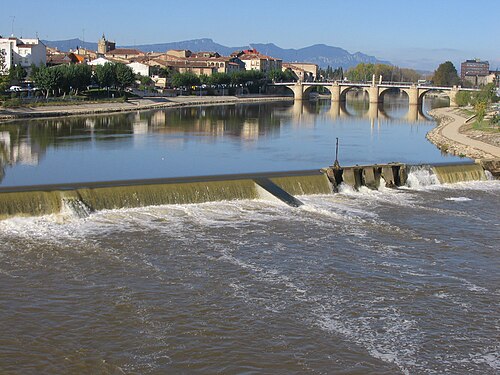
エブロ川(スペイン語およびバスク語[ ˈeβɾo ]ⓘ ;カタルーニャ語: Ebre、西部: [ ˈeβɾe ]、東部: [ ˈeβɾə ] ) は、スペインのイベリア半島の北部および北東部を流れる川ですカンタブリアに源を発し、ほぼ全行程を東南東930 キロメートル (580マイル)。地中海、カタルーニャ南部のテレス・デ・レブレにデルタタホ川に次いで 2 番目流量と流域ドウロ川に次いで 2 番目です。スペイン国内を完全に流れる川としては最長です。他の 2 の川はポルトガル。
エブロ川は多くの都市を流れています (スペイン語: ciudades ): [ a ]カンタブリア州のレイノサ。カスティーリャ・イ・レオンのフリアスとミランダ・デ・エブロ。ラ・リオハ州のハロ、ログローニョ、カラオーラ、アルファロ。ナバラ州Tudela ;アラゴン州のアラゴン、ウテボ、サラゴサ。タラゴナ県(カタルーニャ州)のフリックス、モーラ・デブレ、ベニファレット、ティベニス、ゼルタ、アルドーバー、トルトーサ、アンポスタ。


エブロ川の源流はカンタブリア山脈のフォンティブレ(カンタブリア州、フォンティブレはラテン語のFontes Iberis、つまり「エブロ川の源流」に由来)にあり、大西洋のビスケー湾からわずか42キロメートル(26マイル)の距離にある。近くには、ダム建設によってできた大きな人工湖、エンバルセ・デル・エブロがある。
エブロ川上流はブルゴス県の岩だらけの峡谷を勢いよく流れ、おおよそ東に向かってハロの洞窟群を通り過ぎ、ラ・リオハ州とナバラ州に達すると石灰岩の岩の間でより広い川谷を形成し始める。南側の支流は、スペイン中央部の山脈の一つであるイベリア山脈の近くの分水嶺に源を発する。源流の北にはカンタブリア山脈(ビルバオとサンタンデールの南)がある。エブロ川の総水量の大部分は、フランスとの国境に沿って走るピレネー山脈の南斜面の約3分の2を流域とする北側の支流から来ている。
カンタブリア地方より下流のエブロ川流域では、周囲の山々によって海からの気団が遮断されているため、気候は地中海性気候と大西洋性気候の影響を受け、大陸性気候となる。これは、夏と冬の季節差が大きく、比較的乾燥した気候であることを意味する。エブロ川流域の夏は、多くの場合、半乾燥気候の夏とよく似ている。嵐やにわか雨が降る年もあれば、より乾燥し、高度な灌漑設備が整備されている地域を除いて干ばつに見舞われる年もある。
The valley flood plains experience annual rainfall between 300 and 600 mm (12–24 in), with maxima in fall and spring. It is often covered with chaparral vegetation. Summers are hot and winters are cold. The dry summer season has temperatures of more than 35 °C (95 °F), occasionally reaching over 40 °C (104 °F). In winter, the temperatures often drop below 0 °C (32 °F). In some areas the vegetation depends heavily on moisture produced by condensation fog. It is a continental Mediterranean climate with extreme temperatures. There are many ground frosts on clear nights, and sporadic snowfalls.
The natural topsoils across the plains are, outside of historically well-forested zones, thin. The subsoil being close to the surface is organically poor and quick-draining: calcareous, pebbly, stony layers. These are in places salt-rich, seeing some saltwater endorheic lagoons.
Karst geological processes shaped the landscape of layers of soluble carbonate rock of extensive limestone bedrock formed in an ancient seabed.
The valley expands and the Ebro's flow then becomes slower as its water volume increases, flowing across Aragon. There, larger tributaries flowing from the central Pyrenees and the Iberian System discharge large amounts of water, especially in spring during the thawing season of the mountain snow.
The biomes are diverse in these Mediterranean climate zones: Mediterranean forests, woodlands, and scrub. Hinterlands are particularly distinctive on account of extensive sclerophyll shrublands known as maquis, or garrigues. The dominant species are Quercus coccifera (in drier areas) and Quercus ilex. These trees form monospecific communities or communities integrated with Pinus, Mediterranean buckthorns, Myrtus, Chamaerops humilis, junipers, Pistacia, Rosmarinus, Thymus, and so on.
The hinterland climate becomes progressively more continental and drier, and therefore there is an end from extreme temperatures accompanied by slow-growing dwarf juniper species to unvegetated desert steppes as in "llanos de Belchite" or "Calanda desert".
山岳地帯の植生は、主に乾燥に適応した針葉樹林であり、より湿潤な高地には、一般的に耐性の低いオーク属( Quercus )の樹木が生えている。
塩分濃度の高い環境でも生育する好塩菌(極限環境微生物)は、内陸潟湖とその支流域に豊富に生息している。タマリックスに覆われたこれらの生物群には、蘚苔類、アカザ科、イソマツ科、ルッピア科、スゲ属、ミソハギ科、キク科などの固有種が含まれる。これらの生物の存在は、この谷が海洋起源であること、そして広範囲に堆積した海洋性堆積物と関連している。
カタルーニャ地方に入ると、谷は狭まり、川は山脈に阻まれ、大きく蛇行する。この地域には3つの巨大なダムが建設されている。メキネンサダム(サラゴサ県、1955年)、リバロハダム(1955年)、フリックスダム(1948年)で、後者2つはタラゴナ県にある。川は最後の区間で南に曲がり、壮大な峡谷を流れる。石灰質の崖と高く岩だらけのセラ・デ・カルド山脈は、地中海沿岸地帯を隔てて川にほぼ接している。峡谷を過ぎると、エブロ川はトルトサ付近で再び東に曲がり、タラゴナ県のアンプスタ付近の地中海の三角州に注ぐ。


The Ebro Delta (Catalan: Delta de l'Ebre), in the Terres de l'Ebre ('Ebro Lands') region, Catalonia, is at 340 km2 (130 mi2), or 20km² less,[2] one of the largest wetlands of the western Mediterranean. Designated a Ramsar site,[3] it has entirely grown on soils washed downriver—the historical rate of growth of the delta is demonstrated by the town of Amposta. Recorded and thus confirmed as a seaport in the Roman Warm Period in the 4th century, it is now well inland from the mouths.[2] The rounded form of the delta attests to the subsequent balance between sediment deposition by the Ebro and removal of this material by wave erosion.[2]
The modern delta is in intensive agricultural use for rice, fruit (in particular citrus), and vegetables.[2] The Ebro delta also has numerous beaches, marshes, and salt pans that provide habitat for over 300 species of birds.[2]
The Ebro delta was classified as a wetland area of international interest by Spain's Bureau Mar in 1962.[3] Since a phased-introduction law (1983 to 1986) Spain has designated 7,736 hectares (29.87 mi2) as the Ebro Delta Natural Park (Catalan: Parc Natural del Delta de l'Ebre) to protect its natural resources.[3][2] A network of canals and irrigation ditches dug by agricultural and conservation groups help to maintain the ecologic and economic resources of the delta.
ギリシャ人はこの川を Ἴβηρ ( Ibēr )、abir、ah'irと呼び、ローマ人はHibēr、Ibēr、またはIbērus flūmenと呼び、それが現在の名称につながった。イベリア半島とHibērīまたはIbērī (この地域の人々) は、この川にちなんで名付けられた。[ 4 ]ギリシャ人がこの川に地元の固有名詞を使用したかどうかは確実にはわかっておらず、hibērまたはibērという言葉が何を意味していたかもわかっていない。現代バスク語では、 ibarは「谷」または「水のある牧草地」を意味し、ibai は「川」を意味するが、これらの言葉がエブロ川の語源と関連しているかどうかはわかっていない。バルカン半島には、イバル川(モンテネグロとセルビア) とエヴロス川(ブルガリアとギリシャ)と呼ばれる川がある。ギリシャ語の名前は、川沿いや周辺地域のユダヤ人入植地を指していた可能性があり、ヘブライ語でヘブライ語を話すユダヤ人またはヘブライ語を話す入植地を意味する言葉はIvríまたはIvēríである。
古代において、エブロ川は第一次ポエニ戦争(紀元前264年~241年)後のローマ(北)とカルタゴ(南)の勢力拡大を分ける境界線として利用された。ローマ共和国は、イベリア半島におけるハンニバルの勢力拡大を恐れ、サグントゥム市(エブロ川のかなり南に位置する)をローマの保護領とした。ハンニバルはこの条約違反をローマによる侵略行為とみなし、この出来事を第二次ポエニ戦争の引き金とした。
スペインで最も古いシトー会修道院の一つであるレアル・モナステリオ・デ・ヌエストラ・セニョーラ・デ・ルエダ(文字通り「車輪の聖母の王立修道院」 )は、アラゴン州のエブロ川のほとりに位置しています。1202年に設立されたこの建物は、現在もほぼ完全な形で残っています。この修道院は、スペインで最初に動力生産のために建設された大型水車の一つを使用していたことから、エブロ川と密接な関係があります。また、修道院はエブロ川の流れを迂回させ、建物の循環式水力セントラルヒーティングシステムを構築していました。
The Ebro in 1938 was the starting ground of one of the most famous Republican offensives of the Spanish Civil War. Known as the Battle of the Ebro, the offensive ended in defeat for the Republican forces, although they enjoyed success in its first stages. They were not able to reach their objective of Gandesa.

The Ebro is the most important river in Spain in terms of length, 928 km (577 mi), and area of drainage basin, 85,550 km2 (33,030 mi2). However, the mean annual flow decreased by approximately 29 percent during the 20th century due to many causes: the construction of dams, the increasing demands for irrigation and the evaporation (higher than the rainfall, due to low rainfall, high sunshine and strong and dry winds) from reservoirs in the river basins. This situation has a direct impact on the deltaic system at the mouth of the river because its hydrological dynamics are mainly controlled by the river discharge.
The decrease in river discharge has meant introduction of the salt wedge further into the river. The mean annual river flow is approximately the critical flow which determines the formation and the break-up of the salt wedge. Thus, when the river discharge is between 300 and 400 m3/s (11,000 and 14,000 cu ft/s), the salt wedge can occupy the last 5 km (3 mi) of the estuary, but when the discharge is between 100 and 300 m3/s (3,500 and 10,600 cu ft/s), the salt wedge can advance up to 18 km (11 mi) from the mouth. For less than 100 m3/s (3,500 cu ft/s), the salt wedge quickly advances to its maximum extent, reaching 32 km (20 mi) from the mouth. In addition to decreased mean annual flow, the increased river regulation in the Ebro basin has produced daily and seasonal changes in the flow pattern.
With regards to the sediment load, several authors conclude that the sediment load was reduced by more than 99 percent during the last century. The drastic reduction in sediment transport implies a sediment deficit in the delta, which is causing the erosion of the coastline and lack of sediment replenishment. The unstable surface is due to weather changes and tidal surges. The river floods from time to time, although advance warning can now be given as a result of monitoring within the catchment area. The river flow in Zaragoza during floods, from the end of the 19th century is as follows:
The Ebro poured 1,874 million cubic metres (1,519,000 acre-feet) into the delta from 27 March 2007 to 11 April 2007, with an average of 117 million cubic metres (95,000 acre-feet) per day.
Academics and local government have criticised ecological impacts of:
過去には、数多くの潟湖、内陸塩水池、淡水沼や湿地が干拓され、干上がったり埋め立てられたりしました。河畔林のほぼ全域が農地やパルプ材の植林のために伐採されました。こうした変化により、多くの動植物種が姿を消しました。ダムや水力運河の建設により、河川の動態は変化し、新たな渦巻き、三日月湖、そしてかつて存在した蛇行はもはや形成されなくなりました。時が経つにつれ、これらの現象の多くは干上がったり、堆積物で埋め立てられたりする傾向があります。こうした河川の動態や湿地の小さな痕跡は、保護されています。
エブロデルタ自然公園は、面積7,802ヘクタール(19,280エーカー)で、1986年に正式に設立されました。園内には8種の植物と69種の脊椎動物が生息しており、国際的に重要な地域となっています。また、約95種の鳥類が繁殖しており、越冬する鳥類にとっても非常に重要な場所であるとともに、多くの渡り鳥にとって欠かせない中継地となっています。エブロデルタには、世界最大のオオセグロカモメのコロニーがあり、2006年には過去最高の15,000ペア以上を記録しました。
アメリカザリガニProcambarus clarkiiの導入により経済的損失が発生しており、養殖目的で他地域に導入されたアメリカザリガニの成功は、食用イベリアザリガニを寄せ付けないような攪乱された生息地に定着する能力によるものです。半水生齧歯類のMyocastor coypus は、バスク地方の作物や保護された国立公園に被害を与えながら、エブロ川北西部の支流の一部で生息域を拡大し始めています。エブロ川下流全域で捕獲される魚は水銀含有量が高く、特に巨大なウェルズナマズなど、欧州連合はそれらの販売を禁止しています。
The zebra mussel, an invasive species, is expanding upstream in the Ebro's waters. Due to its rapid rate of reproduction, the species adversely affects the port's underwater machinery as well as that of dams and hydroelectric plants, in addition to competing with native species. Following the introduction of Wels catfish, many fish species' numbers are in clear and rapid decline. Since the Wels catfish's introduction in the Mequinenza reservoir in 1974, it has spread to other parts of the Ebro and its tributaries, especially the Segre. Some endemics species of iberian barbels, genus Barbus in the Cyprinidae, have declined drastically, having once been abundant, especially in the Ebro. Competition and predation by Wels catfish caused its complete disappearance in the middle channel Ebro around 1990. Barbel species from mountain stream tributaries of the Ebro that Wels catfish have not colonized were not affected. The ecology of the river also now has the problem of a major increase in aquatic vegetation, seaweed and algae.
Situated in a single drainage basin, Andorra's main stream, the Riu Valira (also known as Balira), only about 52 km long, has two distinct branches. One of these, the Valira del Norte (24 km), and its principal tributary, the Arinsal River, drain western Andorra. The Valira del Orien (28 km) drains the eastern part and has a tributary, the Madriu. The two branches unite in southwest Andorra to form the Gran Valira which leaves the country to join the Segre River 11 km south of the border in northeastern Spain. The Segre is a tributary of the Ebro; thus, all of Andorra's drainage is Mediterranean.