
Loading article…

Merton was an ancient parish historically in Surrey, but which has since 1965 been part of Greater London. The parish was centred on the 12th-century parish church of St Mary in Merton Park. In 1907 the parish became Merton Urban District. It has formed part of the London Borough of Merton since 1965.
The village of Merton had a linear focus, stretching westwards from the Roman roadStane Street which connected London to Chichester. Locally, the road ran in a direct line from the current Colliers Wood High Street to London Road, Morden, crossing the site of Sainsbury's Savacentre and industrial estates. The name dates back at least to the 7th century, when documents record its use. Translations vary from "Farmstead by the mere (small lake)" to "Maera's homestead".
Merton appears Domesday Book as Meretone. It was revealed in Domesday Book as the largest community in the area. It was held by William the Conqueror as principal feudal overlords and its assets were: 20 hides of land; 1 church, 2 mills worth £3 per annum, 21 ploughs, 12 acres (49,000 m2) of meadow, woodland worth 80 hogs. It rendered £43, added to just under an extra £1 18s 2d from 16 houses in Southwark, to its feudal overlords per annum.[1][2]
The priory or abbey, also known by a third name Priory of St Mary of Merton, was founded by Gilbert Norman in 1114.[3] It is believed to have been the birthplace of Walter de Merton, founder of Merton College, Oxford. In 1235, Henry III held negotiations here with his barons for the Statute of Merton. The Abbey provided the education of Saint Thomas Becket and, it is believed, also Nicholas Breakspear, the only English Pope.
The abbey joined almost all others in ending its existence in 1538, during Henry VIII's reign, having held land throughout the area in volume, such as holdings in Cuddington and tithes in Effingham, due to the Dissolution of the Monasteries.[4] Its buildings were dismantled and the materials removed for reuse elsewhere. It is believed that, in 1496, a hospice for travellers was erected opposite the site of Sainsbury's store. An inn was built there in 1594 and beer was sold there from that date until 2004, when the King's Head closed. The existing building dates from 1931, but it has been designated as a Local Listed Building.

The River Wandle flowing north towards Wandsworth had for centuries driven watermills and provided water for a number of industrial processes. In the 1660s a silk mill was in operation at Merton Abbey and the Jacob family was operating a fabric bleaching ground close by – a process requiring large quantities of water. The name remained associated with the locality as two hundred years later, Stanford's 1862 Library Map of London and its Suburbs[5] shows Jacob's Green at the junction of what are now Christchurch Road and Western Road.
Textile production became the established industry in the area in the 18th century, with calico printing beginning in the 1720s.
In 1764 the merchant Richard Hotham, a member of the East India Company, purchased Moat House Farm, a property to the south of Merton High Street. He began developing the property, enlarging the house and renaming it "Merton Place". He first leased then later sold the house to one of the partners in a local calico works, Charles Greaves.
Hotham next built another house, to the north-west of the junction of Kingston Road and Morden Road. This he called "Hotham House" (later "Merton Grove") and it remained in his possession until his death in 1799.
ワンドル川沿いの工業開発にもかかわらず、19世紀初頭のマートンは依然として主に農村地帯であった。人口は住宅建設に伴い急激に増加した時期があり、右図に示すように、1811年から1841年にかけて約2倍になり、その後40年間は比較的横ばい状態が続き、1911年までの10年間でほぼ3倍になり、そして既に郊外化が進んでいた1921年から1951年にかけてさらに2倍以上に増加し、大部分が都市中心部となった。
1803年、ワンズワースとクロイドンを結ぶサリー鉄鋼鉄道が開通した。この鉄道は浅いワンドル渓谷に沿って走り、南へマートンとミッチャムを経由した。馬車牽引の鉄道であったが、浅い川沿いの産業がテムズ川の埠頭へ商品を輸送するための貨物輸送サービスを提供した。マートン・ハイストリートから、鉄道はクライストチャーチ・ロードに沿って走り、ミッチャムの路面電車停留所の手前で南西方向へと進路を変えた。
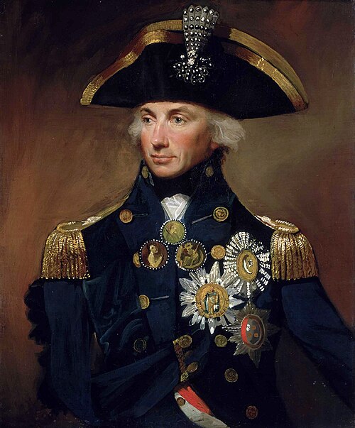
1802 年 9 月、ホレイショ・ネルソン中将は、愛人のエマ・ハミルトンとその夫であるウィリアム・ハミルトン卿の助言を受けて、チャールズ・グリーブスの未亡人からマートン・プレイスとその農地および森林を 9,000 ポンド ( 2025 年換算で 758,547 ポンド)で購入した。18 世紀初頭頃にクイーン・アン様式の重厚で左右対称の正方形の建物として建てられたこの家は、ひどく荒廃していたが、ネルソンは弁護士の助言に反して、より低い金額を提示することを拒否し、友人からお金を借りて支払った。[ 7 ]彼は家の南側に土地を追加購入して領地を拡張し、マートンの所有地はワンドル川の西側とモーデン・ホール・パークの北側のほとんどの地域、マートン・ロード、サウス・パーク・ロード、ヘイドンズ・ロードの間の地域を含む範囲を占めるようになった。ネルソンは航海の合間に、マートン・プレイスでエマとウィリアム卿と三人で暮らしていたが、夫婦はピカデリーにもロンドンの家を所有しており、エマは1803年4月にウィリアム卿が亡くなった後、近くに小さな家を借りた。エマはネルソンへの敬意を表して内装を飾り始め、かなり「けばけばしく雑然とした」雰囲気を作り出し、それは広く模倣された。彼女は庭園を計画し、小川や池に魚を放ち、敷地内に豚、鶏、羊を放し飼いにし、彼女とネルソンは共にその土地を「農場」と呼んでいた。彼らの娘ホレイシアは、そこで長期間彼らと過ごした。[ 7 ]
ネルソンは、1805年10月のトラファルガーの戦いで戦死するまで、海に出ていない時はほぼ4年間ここに住んでいた。トラファルガーでのネルソンの功績と犠牲を称え、1805年11月にネルソンの長兄ウィリアムがネルソン伯爵とマートン子爵に叙せられたが、後者はマートンに住むことはなかった。エマとホレイシアはネルソンが遺言の付則で意図し示した方法では遺贈されなかったが、エマはマートン・プレイスを相続した。しかし、それに伴うわずかな年金では邸宅を維持するには不十分で、ネルソンの親族が滞在し続け、エマは次々と届く備品や家具の費用を支払わなければならなかった。すぐにエマは借金を抱え、競売で落札された後、最終的に1809年にアッシャー・ゴールドスミッド(エマの友人アブラハムの兄弟)に邸宅が売却された。[ 7 ]
この家は1821年に取り壊され[ 8 ]、その後数年間にわたって敷地は分割して売却された。ハイストリートのすぐ南にあるマートンプレイス団地の一部は小規模住宅地として開発され、ネルソンズフィールズとして知られるようになった。ハイストリートの北側は世紀末まで未開発のままだった。この場所の歴史は、ネルソンロード、トラファルガーロード、ビクトリーロード、ハーディロード、ハミルトンロードといった地元の通りの名前に反映されている。
より新しい蒸気機関車鉄道との競争により、サリー・アイアン鉄道は1846年に閉鎖された。その後、路線の一部は、 1855年にマートン、モーデン、ミッチャムを経由して開通したウィンブルドン・アンド・クロイドン鉄道によって再利用された。
1860年代には、バイグローブ・ロードとワンドル・バンクの交差点に製粉工場があり、マートン・ハイ・ストリートには銅圧延工場があった。後にマートン・ボード・ミルズが建設されることになる場所である。この工場は1815年までにジェームズ・シアーズ・アンド・サンズ社の所有となり、少なくとも1867年までは同社の所有であった。さらに南には、マートン・アビー・ハウスに隣接する土地の両岸に、マートン・アビー・ミルズ複合施設が建設されていた。
1868年、トゥーティング・マートン・アンド・ウィンブルドン鉄道(TM&WR)は、ウィンブルドン・アンド・クロイドン鉄道から分岐し、マートン・パーク駅(現在のマートン・パーク路面電車停留所)とトゥーティング・ジャンクション駅(現在のトゥーティング駅)を結ぶ支線を開通させた。ネルソンの旧邸宅とマートン・アビーの跡地を横切るように、マートン・アビー駅はステーション・ロードの南側に建設され、その地域の工業団地へのサービス提供に利用された。シアーズ家の一員であるウィリアム・シアーズは、この会社の取締役の一人であった。
Continuing the long association of Merton with textile printing, the Arts and Crafts designer William Morris opened Merton Abbey Works in 1881. Close by, the firm of Edmund Littler at Merton Abbey Mills was known for its high-quality printing and was by the 1890s sending its entire production to Liberty & Co. in Regent Street. Liberty & Co. subsequently took over the production at Merton from Littler.
Industry developed further around the Wandle and residential development began in the late Victorian period north of the High Street and along Kingston Road and in Merton Park. In 1894, when a new Local Government Act was implemented, the parish of Merton was still considered sufficiently rural to be included as part of the CroydonRural District (CRD).
Following the earlier lead of neighbouring Wimbledon, Merton underwent a transformation in the first two decades of the 20th century that saw its fields developed from east to west. Population growth lead to the removal of Merton from the CRD and the creation of the separately administered Merton Urban District in 1907. Between 1901 and 1921 the parish's population nearly quadrupled from 4,510 to 16,177.
In 1913, the parish of Morden was also removed from the CRD and merged with the Merton Urban District to form the Merton and Morden Urban District.
Hotham's Merton Grove House survived until the beginning of the 20th century, but had been demolished and redeveloped for housing by 1913. The Grove Tavern on the opposite side of Kingston Road remembers the name.
Growth was stimulated and assisted by the arrival of trams in Merton High Street in the first decade of the century and the opening of a new bus garage at the east end of Merton High Street in 1913. The combination of tram services and the extension of the Underground Electric Railways Company of London's City & South London Railway through Colliers Wood and South Wimbledon to Morden, in 1926, destroyed demand for passenger services on the Merton Abbey branch line and these were ended in 1929. Goods operations continued until 1975, when the line was closed and the tracks lifted.
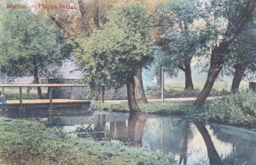
Liberty & Co. continued to operate the Merton Abbey Mills until 1972. From the 1930s, extensive industrial estates were laid out from Lombard Road on the southern part of the former Merton Place estate between Morden Road and Phipps Bridge.
The section of the TM&WR route east of Morden Road was used to construct Merantun Way (A24) in the early 1990s. The road was built to relieve traffic congestion on Merton High Street and was originally planned to continue to the west, along the route of the defunct railway to Kingston Road, with a flyover across Morden Road. This section of the route was never constructed, although the space between the carriageways where Merantun Way meets Morden Road provides the space for a flyover bridge to be constructed.

During the 20th century, the waters of the Wandle became less important to the industries remaining in the Merton Abbey complex and, in the 1980s and 1990s, the majority of these closed down or moved elsewhere. The Sainsbury's Savacentre occupies part of the site and the Mill buildings were refurbished and developed as a popular heritage and craft centre. The Colour House, where Liberty dyed fabric, was opened as a theatre in 1995. The ruined chapterhouse of the Abbey was also used as a venue for several theatrical performances in the late 1990s.
When automatic telephone exchanges were introduced in the UK, the code for the Merton and South Wimbledon telephone exchange was set as 542 and used the mnemonic "LIBerty", based on the numbers on a telephone to which the letters are assigned; the mnemonic was derived from Liberty fabric works. The use of letter codes was dropped in the late 1960s.
Until the 20th century, most of the parish remained rural in character and the main residential and commercial centres were at Merton Park and along Merton High Street between modern South Wimbledon and Colliers Wood. Other modern areas included within the parish area are:
It is bounded by Wimbledon to the north, Mitcham to the east, Morden, Cheam and Cuddington (Worcester Park and rest of Motspur Park) to the south and (New) Malden to the west. The 1871 Ordnance Survey map records its area as 1,764.7 acres (7.1 km2) (2.7 sq mi).
A small memorial exists on the site of Merton Place. Other commemorations of Nelson's association with the parish are the former Nelson Hospital on Kingston Road, reopened in 2015 as the Nelson Health Centre;[9] and, until it was closed in 2011, the Emma Hamilton public house at Wimbledon Chase.
モーデン・ロード沿いのネルソン・トレーディング・エステート、そしてマートン・ハイ・ストリートから分岐するハミルトン・ロード、ハーディ・ロード、ネルソン・ロード、ビクトリー・ロード、トラファルガー・ロードは、いずれもかつてマートン・プレイス・エステートの一部だった土地に建てられている。
ネルソンとエマの席は聖マリア教会に残されており、教会の北側通路の壁にはネルソンとウィリアム・ハミルトン卿の葬儀用紋章が飾られている。教会の外、チャーチ・パス沿いには「ネルソンの階段」(現在はやや草木に覆われている)があり、ネルソンが馬に乗る際に使ったと言われている。ここは小さな自然保護区の一部となっている。
マートン・アビー地区(メラントゥン・ウェイを含む)で行われた建設工事により、マートン修道院の遺跡が発見されました。これらの遺跡は可能な限り保護・保存されています。今後、さらなる考古学的発掘調査が計画されています。
1881年当時、イギリス国内でマートンという姓の主な集中地は、 DA郵便番号地域を除いてすべて南東イングランド以外にありました。これは、この姓が現在グレーターロンドンにあるマートン以外の場所から派生したことを示しています。[ 10 ]マートン区は、中世の教区や都市にちなんで名付けられたロンドンの区(全32区中)24区のうちの1つです。
北緯51度24分37秒、西経0度12分09秒/北緯51.4102度、西経0.2024度/北緯51.4102度、西経-0.2024度