
Loading article…
マレー川(南オーストラリア州では、マレー川[注1 ] 、ンガリンジェリ語: Millewa、ヨルタヨルタ語: Dhungala [ 4 ]またはTongala)[ 5 ]は、オーストラリア南東部を流れる川です。全長2,508 km(1,558マイル)で、オーストラリア最長の川です。[ 6 ]その支流には、オーストラリアで次に長い6つの川のうち5つ(マランビジー川、ダーリング川、ラフラン川、ワレゴ川、パルー川)が含まれています。マレー川の流域と合わせて、これらの川の流域はマレー・ダーリング盆地を形成し、オーストラリアの面積の約7分の1を占めています。ここは、オーストラリアで最も重要な灌漑地域として広く認識されています。
マレー川はオーストラリア・アルプスに源を発し、オーストラリア最高峰の西側を流れ、その後、オーストラリアの内陸平野を北西に蛇行しながら流れ、ニューサウスウェールズ州とビクトリア州の境界を形成し、南オーストラリア州へと流れ込む。東西方向からモーガンで南に向きを変え、最後の315 km (196マイル)を流れ、塩分濃度が変動するアレクサンドリナ湖の東端に達する。その後、水はヒンドマーシュ島とムンドゥー島の周りのいくつかの水路を流れる。そこで南東のクーロンからのラグーンの水と合流し、グールワ・サウスの東10 km (6.2マイル)にあるマレー河口を通ってエンカウンター湾(南氷洋の湾)に流れ込む。[ 7 ]大規模な河川改修が始まる前は、かなりの量の水を排出していたにもかかわらず、マレー河口の水はほぼ常に流れが遅く浅い。
2010年現在マレー川水系は自然流量の58 パーセントを受け入れたが、この数値はかなり変動する。 [ 8 ]
ビクトリア州とニューサウスウェールズ州(NSW)の境界は、マレー川の南岸または左岸の頂上に沿っており、川の中央ではなく、南岸(ビクトリア州側)の頂上です。つまり、南オーストラリア州に到達するまでのマレー川全体(水と川底を含む)はニューサウスウェールズ州内にあります。[ 9 ]
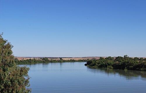

マレー川は、全長3,750km (2,330マイル)に及ぶマレー・ダーリング川水系の一部を形成しており、ビクトリア州、ニューサウスウェールズ州、クイーンズランド州南部の内陸部の大部分を流域としている。マレー川の水量は、世界の他の地域にある同規模の河川と比べてごくわずかであり、年間流量の変動も大きい。公式記録が始まって以来、極端な干ばつにより完全に干上がったことが3回ある。多くの場合、河口に砂州が形成され、流れが止まった。
マレー川はニューサウスウェールズ州とビクトリア州の境界であり、具体的には左岸の上流(つまり川のビクトリア州側)である。[ 10 ] 1980年の判決で、オーストラリア高等裁判所は、川のビクトリア州側の川岸で釣りをしていた男性の不法死亡事件について、どちらの州が管轄権を持つかという問題について判決を下した。[ 11 ]川は時間の経過とともに流路を変え、川岸の一部も改変されているため、この境界の定義は曖昧になる可能性がある。
東経141度の線から西に11 km (6.8マイル)の範囲では、 [注 2 ]川の中央でビクトリア州と南オーストラリア州の境界となっている。[ 12 ]このずれは、境界が最初に測量された1840年代に東西方向に3.72キロメートル (2.31マイル) の計算ミスがあったために生じ、長期にわたる境界紛争につながった。この区間より西側では、[注 3 ]マレー川は完全に南オーストラリア州内にある。
川を中心とするマレー農業地域は、 9つの地方自治体区域から構成されています。[ 13 ]
川の源流から南氷洋までの、川沿いの主要な集落と、2016年のオーストラリア国勢調査に基づく人口は以下のとおりです。
The Murray and its tributaries support a variety of river life adapted to its vagaries. This includes native fish such as the famous Murray cod, trout cod, golden perch, Macquarie perch, silver perch, eel-tailed catfish, Australian smelt and western carp gudgeon, as well as other aquatic species such as the Murray short-necked turtle, broad-clawed yabbies and the large-clawed Macrobrachium shrimp 67, in addition to aquatic species more widely distributed through Southeastern Australia such as common long-necked turtles, common yabbies, the small claw-less paratya shrimp, water rats and platypus. The Murray crayfish, an endangered species, was able to increase its numbers thanks to scientists.[29] The Murray also supports fringeing corridors and forests of the river red gum.
The health of the Murray has declined significantly since European settlement, particularly through regulation of its flows. Extreme droughts between 2000 and 2007 put significant stress on river red gum forests, leading to mounting concern over their long-term survival. The Murray has also flooded on occasion. The most significant was the flood of 1956: lasting for up to six months, it inundated many towns on its lower reaches in South Australia.
Between 2.5 and 0.5 million years ago, the Murray terminated in a vast freshwater lake – Lake Bungunnia – formed by earth movements that blocked the river near Swan Reach. At its maximum extent, Lake Bungunnia covered 33,000 km2 (12,741 sq mi), extending to near the Menindee Lakes in the north and to near Boundary Bend in the south.[30] The draining of Lake Bungunnia occurred approximately 600,000 years ago.[31]
Deep clays deposited by the lake are evident in cliffs around Chowilla in South Australia. Considerably higher rainfall would have been required to keep such a lake full; the draining of Lake Bungunnia appears to have marked the end of a wet phase in the history of the Murray–Darling Basin and the onset of widespread arid conditions similar to today. A species of Neoceratoduslungfish existed in Lake Bungunnia;[32] today Neoceratodus lungfish are only found in several Queensland rivers.
The noted Barmah River red gum forests owe their existence to the Cadell Fault. About 25,000 years ago, displacement occurred along this fault, raising its eastern edge, which runs north–south, 8 to 12 m (26 to 39 ft) above the floodplain. This created a complex series of events. A section of the original Murray River channel immediately behind the fault was rendered abandoned (it exists today as an empty channel known as Green Gully). The Goulburn River was dammed by the southern end of the fault to create a natural lake.
The Murray River flowed to the north around the Cadell Fault, creating the channel of the Edward River which exists today and through which much of the Murray's waters still flow. Then the natural dam on the Goulburn River failed, the lake drained, and the Murray changed its course to the south and started to flow through the smaller Goulburn River channel, creating "The Barmah Choke" and "The Narrows" (where the river channel is unusually narrow), before entering into the proper Murray River channel again.
The primary result of the Cadell Fault – that the west-flowing water of the Murray River strikes the north–south fault and diverts both north and south around the fault in the two main channels (Edward and ancestral Goulburn) in addition to a fan of small streams, and regularly floods a large amount of low-lying country in the area. These conditions are perfect for river red gums, which rapidly formed forests in the area. Thus the displacement of the Cadell Fault 25,000 BP led directly to the formation of the famous Barmah river red gum forests.
The Barmah Choke and The Narrows restrict the amount of water that can travel down this part of the Murray. In times of flood and high irrigation flows the majority of the water, in addition to flooding the red gum forests, actually travels through the Edward River channel. The Murray has not had enough flow power to naturally enlarge The Barmah Choke and The Narrows to increase the amount of water they can carry.
The Cadell Fault is quite noticeable as a continuous, low, earthen embankment as one drives into Barmah from the west, although to the untrained eye it may appear man-made.

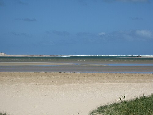
The Murray Mouth is the point at which the Murray River empties into the sea,[7] and the interaction between its shallow, shifting and variable currents and the open sea can be complex and unpredictable. During the peak period of Murray River commerce (roughly 1855 to 1920), it presented a major impediment to the passage of goods and produce between Adelaide and the Murray settlements, and many vessels foundered or were wrecked there.
Since the early 2000s, dredging machines have operated at the Murray Mouth for 24 hours a day, moving sand from the channel to maintain a minimal flow from the sea and into the Coorong's lagoon system. Without the dredging, the mouth would silt up and close, cutting the supply of fresh sea-water into the Coorong National Park, which would then warm up, stagnate and die.
Being one of the major river systems on one of the driest continents on Earth, the Murray has significant cultural relevance to Aboriginal Australians. According to the people of Lake Alexandrina, the Murray was created by the tracks of the Great Ancestor, Ngurunderi, as he pursued Pondi, the Murray cod. The chase originated in the interior of New South Wales. Ngurunderi pursued the fish (who, like many totem animals in Aboriginal myths, is often portrayed as a man) on rafts (or lala) made from red gums and continually launched spears at his target. But Pondi was a wily prey and carved a weaving path, carving out the river's various tributaries. Ngurunderi was forced to beach his rafts, and often create new ones as he changed from reach to reach of the river.
At Kobathatang, Ngurunderi finally got lucky and struck Pondi in the tail with a spear. However, the shock to the fish was so great it launched him forward in a straight line to a place called Peindjalang, near Tailem Bend. Eager to rectify his failure to catch his prey, the hunter and his two wives (sometimes the escaped sibling wives of Waku and Kanu) hurried on, and took positions high on the cliff on which Tailem Bend now stands. They sprung an ambush on Pondi only to fail again. Ngurunderi set off in pursuit again but lost his prey as Pondi dived into Lake Alexandrina. Ngurunderi and the women settled on the shore, only to suffer bad luck with fishing, being plagued by a water fiend known as Muldjewangk. They later moved to a more suitable spot at the site of present-day Ashville. The twin summits of Mount Misery are said to be the remnants of his rafts; they are known as Lalangengall or the two watercraft.
This story of a hunter pursuing a Murray cod that carved out the Murray persists in numerous forms in various language groups that inhabit the enormous area spanned by the Murray system. The Wotojobaluk people of Victoria tell of Totyerguil from the area now known as Swan Hill, who ran out of spears while chasing Otchtout the cod.
Roonka Flat, near Blanchetown, was a site of occupation since at least 7000BC.
The first Europeans to encounter the river were Hamilton Hume and William Hovell, who crossed the river where Albury now stands in 1824: Hume named it the Hume River after his father. In 1830, Captain Charles Sturt reached the river after travelling down its tributary the Murrumbidgee River and named it the Murray River in honour of the then British Secretary of State for War and the Colonies, Sir George Murray, not realising it was the same river that Hume and Hovell had encountered further upstream.
Sturt continued down the remaining length of the Murray to finally reach Lake Alexandrina and the river's mouth. The vicinity of the Murray Mouth was explored more thoroughly by Captain Collet Barker in 1831.
The first three settlers on the Murray River are known to have been James Collins Hawker (explorer and surveyor) along with Edward John Eyre (explorer and later Governor of Jamaica) plus E.B. Scott (onetime superintendent of Yatala Labour Prison). Hawker is known to have sold his share in the Bungaree Station, which he founded with his brothers, and relocated alongside the Murray at a site near Moorundie.[33]
In 1852, Francis Cadell, in preparation for the launch of his steamer service, explored the river in a canvas boat, travelling 1,300 miles (2,100 km) downstream from Swan Hill.[34]
In 1858, while acting as Minister of Land and Works for New South Wales, Irish nationalist and founder of Young Ireland, Charles Gavan Duffy, founded Carlyle Township on the Murray River, after his close friend, Scottish historian and essayist Thomas Carlyle. Included in the township were "Jane Street", named in honour of Carlyle's wife Jane Carlyle and "Stuart-Mill Street" in honour of political philosopher John Stuart Mill[35]
In 1858, the Government Zoologist, William Blandowski, together with Gerard Krefft, explored the lower reaches of the Murray and Darling rivers, compiling a list of birds and mammals.
George "Chinese" Morrison, then aged 18, navigated the river by canoe from Wodonga to its mouth, in 65 days, completing the 1,555-mile (2,503 km) journey in January 1881.[36]
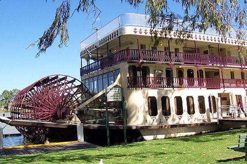
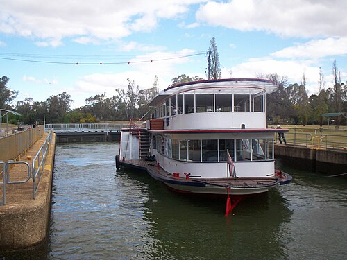
Shipping cannot enter the Murray from the sea because it does not have an estuary. However, in the 19th century the river supported a substantial commercial trade using shallow-draft paddle steamers, the first trips being made by two boats from South Australia on the spring flood of 1853. The Lady Augusta, captained by Francis Cadell, reached Swan Hill while another, Mary Ann, captained by William Randell, reached Moama (near Echuca).[37] In 1855 a steamer carrying gold-mining supplies reached Albury but Echuca was the usual turn-around point, though small boats continued to link with up-river ports such as Tocumwal, Wahgunyah and Albury.[38]
The arrival of steamboat transport was welcomed by pastoralists who had been suffering from a shortage of transport due to the demands of the gold fields. By 1860 a dozen steamers were operating in the high water season along the Murray and its tributaries. Once the railway reached Echuca in 1864, the bulk of the woolclip from the Riverina was transported via river to Echuca and then south to Melbourne.
The steam paddleship Etona was launched as a mission steamer, replacing an earlier steam launch, also named Etona, which had been operating on the Murray since 1891. The vessel was based at Murray Bridge, and operated between Goolwa and the Victorian border, stopping at towns such as Mannum, Morgan and Renmark as well as isolated settlements and workcamps.[39] The forepart of the vessel was used as a chapel fitted with an altar and organ, with a capacity of 20 people.[40] There was also a cabin. The minister on board, Rev. William Bussell, doubled as captain.[41][39] On 16 August 1898, Etona arrived at Renmark, where the Bishop of Adelaide, Rev. Dr. John Harmer, held services the following Sunday with the assistance of Rev H M Wylie.[42] In September of the same year, the service due in Holder on the 18th was suspended due to the vessel grounding on a sandbank.[43] During its year of launch, the boiler of Etona gave way, being replaced at a cost of £87.[44]
The Murray was plagued by "snags", fallen trees submerged in the water, and considerable efforts were made to clear the river of these threats to shipping by using barges equipped with steam-driven winches. In recent times, efforts have been made to restore many of these snags by placing dead gum trees back into the river. The primary purpose of this is to provide habitat for fish species whose breeding grounds and shelter were eradicated by the removal of the snags.[45]
Author E.J. Brady chronicled an eventful journey downriver in a small motor boat from Albury to the coast in 1911 in River Rovers.[46]

The volume and value of river trade made Echuca Victoria's second port and in the decade from 1874 it underwent considerable expansion. By this time up to thirty steamers and a similar number of barges were working the river in season. River transport began to decline once the railways touched the Murray at numerous points. The unreliable levels made it impossible for boats to compete with the rail and later road transport. However, the river still carries pleasure boats along its entire length.
Today, most traffic on the river is recreational. Small private boats are used for water skiing and fishing. Houseboats are common, both commercial for hire and privately owned. There are a number of both historic paddle steamers and newer boats offering cruises ranging from half an hour to five days.
The Murray River has been a significant barrier to land-based travel and trade. Many of the ports for transport of goods along the Murray have also developed as places to cross the river, either by bridge or ferry. The first bridge to cross the Murray, which was built in 1869, is in the town of Murray Bridge, formerly called Edwards Crossing. To distinguish this bridge from the many others that span the Murray River, this bridge is known as Murray River road bridge, Murray Bridge Tolls applied on South Australian ferries until abolished in November 1961.[47]

Small-scale pumping plants began drawing water from the Murray in the 1850s and the first high-volume plant was constructed at Mildura in 1887. The introduction of pumping stations along the river promoted an expansion of farming and led ultimately to the development of irrigation areas (including the Murrumbidgee Irrigation Area).[48]
In 1915, the three Murray states – New South Wales, Victoria, and South Australia – signed the River Murray Agreement which proposed the construction of storage reservoirs in the river's headwaters as well as at Lake Victoria near the South Australian border. Along the intervening stretch of the river a series of locks and weirs were built. These were originally proposed to support navigation even in times of low water, but riverborne transport was already declining due to improved highway and railway systems.
The disruption of the river's natural flow, run-off from agriculture, and the introduction of pest species such as the European carp has led to serious environmental damage along the river's length. There are widespread concerns that the river will be unusably salty in the medium to long term – a serious problem given that the Murray supplies 40 per cent of the water supply for Adelaide. Efforts to alleviate the problems have proceeded but disagreement between various groups has hampered progress.
Introduced fish species such as carp, gambusia, weather loach, redfin perch, brown trout, and rainbow trout have also had serious negative effects on native fish. The most pernicious are carp, which have contributed to environmental degradation of the Murray and its tributaries by destroying aquatic plants and permanently raising turbidity. Carp is the most common species, and can be found in all segments of the river.[49]
Four large reservoirs were built along the Murray. In addition to Lake Victoria (completed late 1920s), these are Lake Hume near Albury-Wodonga (completed 1936), Lake Mulwala at Yarrawonga (completed 1939), and Lake Dartmouth, which is actually on the Mitta Mitta River upstream of Lake Hume (completed 1979). The Murray also receives water from the complex dam and pipeline system of the Snowy Mountains Scheme. An additional reservoir was proposed in the 1960s at Chowilla Dam, which was to have been built in South Australia and would have flooded land mostly in Victoria and New South Wales. It was cancelled in favour of building Dartmouth Dam due to costs and concerns relating to increased salinity.

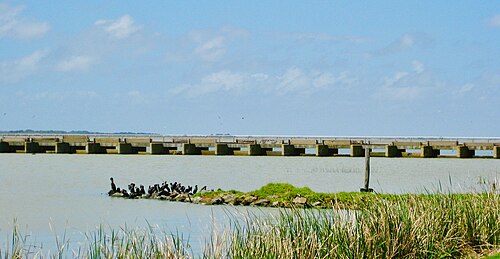
From 1935 to 1940 a series of barrages was built near the Murray Mouth to stop seawater entering the lower part of the river during low flow periods. They are the Goolwa Barrage, with a length of 632 metres (2,073 ft); Mundoo Channel Barragel 800 metres (2,600 ft); Boundary Creek Barragel 243 metres (797 ft); Ewe Island Barrage, 853 metres (2,799 ft); and Tauwitchere Barrage, 3.6 kilometres (2.2 mi).

These dams inverted the patterns of the river's natural flow from the original winter-spring flood and summer-autumn dry to the present low level through winter and higher during summer. These changes ensured the availability of water for irrigation and made the Murray Valley Australia's most productive agricultural region, but have seriously disrupted the life cycles of many ecosystems both inside and outside the river, and the irrigation has led to dryland salinity that now threatens the agricultural industries.
In 2006, the Government of South Australia released a plan to investigate the construction of controversial Wellington Weir.
Lock 1 was completed near Blanchetown in 1922. Torrumbarry weir downstream of Echuca began operating in December 1923. Of the several locks that were proposed, only thirteen were completed; Locks 1 to 11 on the stretch downstream of Mildura, Lock 15 at Euston and Lock 26 at Torrumbarry. Construction of the remaining weirs purely for navigation purposes was abandoned in 1934. The last lock to be completed was Lock 15, in 1937.[50] Lock 11, just downstream of Mildura, creates a 100-kilometre (62 mi) long lock pool that aided irrigation pumping from Mildura and Red Cliffs.
Each lock has a navigable passage next to it through the weir, which is opened during periods of high river flow, when there is too much water for the lock. The weirs can be completely removed, and the locks completely covered by water during flood conditions. Lock 11 is unique in that the lock was built inside a bend of the river, with the weir in the bend itself. A channel was dug to the lock, creating an island between it and the weir. The weir is also of a different design, being dragged out of the river during high flow, rather than lifted out.
Major tributaries
Population centres
オンラインオーディオなど