
Loading article…
東ガーツ山脈は、インド半島の東海岸に沿って1,750 km (1,090マイル)にわたって伸びる山脈です。面積は75,000 km 2 (29,000平方マイル)で、オリッサ州、テランガーナ州、アーンドラプラデーシュ州、カルナータカ州、タミル ナードゥ州を横断しています。この山脈は、デカン高原の東端に沿って不連続な山脈を形成し、オリッサ州のマハナディ川の北から半島の南端にあるタミル ナードゥ州のヴァイガイ川まで伸びています。東ガーツ山脈はニルギリで西ガーツ山脈と合流します。平均標高は約600 m (2,000フィート)で、アルマ コンダは山脈の最高峰で、標高は1,680 m (5,510フィート)です。
地質学的証拠によれば、これらの山脈は始生代に形成され、超大陸ロディニアの分裂とゴンドワナの形成後にインド亜大陸の一部となった。山脈は中期原生代にさらなる変成作用を受けて形成された。山脈の北部は標高900~1,400m (3,000~4,600フィート)で、大部分がオリッサ州に位置する。中央部はペンナ川まで伸びており、平均標高520m (1,710フィート)の2つの平行な山脈から構成されている。山脈の南端は、いくつかの小さな丘で構成されている。
The Eastern Ghats form a part of one of the major watersheds of India, consisting of many perennial river systems such as the Godavari, Krishna, Mahanadi and Kaveri. Because of the higher elevation of the Deccan Plateau on the west, most rivers originate from the Western Ghats and flow eastwards to cut across the range to the Bay of Bengal. As the mountains are discontinuous and have a lower elevation, they have a considerably lesser influence than the Western Ghats on the weather patterns in India. However, orography studies indicate that the range does play a role in bringing rainfall to the eastern coastal areas.
The weather is normally dry and humid with seasonal rainfall. There are nine different forest types found in the region including evergreen, deciduous and thorn forests. The Eastern Ghats region contains a large number of different species of flora and fauna, some of which are endemic to this region.
The name Eastern Ghats derives from the word ghat and the cardinal direction in which it is located with respect to the Indian mainland. Ghat, a term used in the Indian subcontinent, depending on the context, could either refer to a range of stepped hills such as the Western Ghats and Eastern Ghats, or a series of steps leading down to a body of water or wharf.[3][4] As per linguist Thomas Burrow, the word Ghat was derived from similar words used in various Dravidian languages such as kattu (mountain side, ridge, or dam) in Tamil, katte (dam), gatta (mountain), and gatte (bank or shore) in Kannada, and katta (dam), and gattu (shore or embankment) in Telugu.[5]

東ガーツ山脈は、始生代の地殻岩石の衝突によって形成され始めた古代の造山帯です。地質学的証拠は、これらの山脈が超大陸ロディニアの分裂とゴンドワナの形成後にインド亜大陸の一部になったことを示しています。これらの山脈は、数百万年かけて変成作用と侵食によって形成され、西ガーツ山脈よりもはるかに古いものです。[ 6 ] [ 7 ]岩石層は主に中期原生代にシルト、炭酸塩、玄武岩が堆積して形成され、後にコンドライトとケイ酸カルシウム岩になりました。主な岩石の種類は、チャーノカイト、花崗岩、コンドライト、変成岩、珪岩です。[ 7 ] [ 8 ]
中原生代には、山脈は圧縮され、北東方向に再配列されました。この構造には、山脈に沿って複数の衝上断層と横ずれ断層が含まれています。 [ 9 ]ティルマラ丘陵のエパルカエアン不整合は、地層学的に重要な大きな不連続面であり、急な自然斜面や渓谷から明らかなように、広範囲にわたる侵食と非堆積の期間を表しています。 [ 10 ] [ 11 ]西端に沿って、火山活動により堆積岩が堆積し、後に片岩帯を形成しました。この地域は、ボーキサイト、鉄鉱石、石灰岩の埋蔵量で構成されています。主な土壌の種類は、赤色、黒色、ラテライト、沖積土です。[ 7 ]
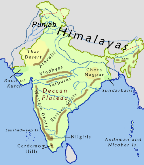
東ガーツ山脈はマハナディ川の北から始まり、インド半島南部のヴァイガイ川流域まで約1,750 km (1,090マイル)にわたって伸びています。 [ 12 ]面積は160,000 km² (62,000平方マイル)で、インドのオリッサ州(25%)、テランガーナ州(5%)、アーンドラ・プラデーシュ州(40%)、カルナータカ州(5%)、タミル・ナードゥ州(25%)を横断しています。[ 13 ] [ 14 ] : 24
東ガーツ山脈は、平均標高600 m (2,000フィート)の不連続な山脈を形成し、ベンガル湾に沿ってインド東海岸と平行に走っています。 [ 7 ] [ 15 ]東海岸平野は、東ガーツ山脈とベンガル湾の間の100~130 km (62~81マイル)幅の地域です。 [ 16 ] [ 17 ]山脈の平均幅は100~200 km (62~124マイル)で、北部は広く、南部は狭くなっています。[ 12 ] [ 14 ]アルマ・コンダは、標高1,680 m (5,510フィート)で、山脈の最高峰です。[ 15 ] [ 18 ]
この山脈は、おおよそ 3 つの独立したセクションに分けられます。山脈の北部セクションは主にオリッサ州にあり、北部のシミリパル丘陵からアンドラ プラデーシュ州との境界まで伸びています。標高は900 ~ 1,400 m (3,000 ~ 4,600フィート)で、最高峰はデオマリ(1,672 m) です。[ 18 ] [ 14 ] : 24中央セクションはテランガーナ州とアンドラ プラデーシュ州にあり、ペンナ川まで伸びています。平均標高520 m (1,710フィート)の 2 つの平行な山脈で構成され、ゴダヴァリ川とクリシュナ川が流れる160 km (99マイル)の峡谷によって隔てられています。丘陵はチェンナイの南でジャヴァディ丘陵とシェヴァロイ丘陵として続き、ニルギリで西ガーツ山脈と合流します。カルナータカ州のビリギリランガ丘陵とマレ・マハデシュワラ丘陵はタミル・ナードゥ州のタラマライまで伸びており、西ガーツ山脈とはモヤール川の谷で隔てられている。[ 19 ]南端では、東ガーツ山脈はシルマライなどのいくつかの小さな丘陵で構成されている。[ 15 ] [ 18 ] [ 14 ] : 24

東ガーツ山脈はインドの主要な分水嶺の一つであり、ゴダヴァリ川、カーヴェリ川、クリシュナ川、マハナディ川などの主要な河川系が山脈を横断している。[ 7 ] [ 18 ] [ 20 ]ほとんどの河川は東から西に向かうにつれて勾配が急になるため、東に向かってベンガル湾へと流れている。[ 21 ]東ガーツ山脈は、東海岸平野の多くの小中河川の源流となっている。[ 22 ]
この地域には、小川や川から数多くの滝が生まれています。また、チリカ湖、コレル湖、プリカット湖などの多くの湿地や大きな沿岸ラグーンも存在します。[ 14 ] : 36川には水力発電や灌漑のためにダムが建設され、主要な貯水池が地域全体に点在しています。[ 23 ] [ 24 ]
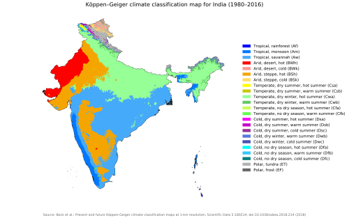
山脈は断続的で標高が低いため、インドの気象パターンに対する影響は西ガーツ山脈に比べてかなり小さい。しかし、地形研究によると、この山脈は沿岸の降雨パターンに役割を果たしている。山脈は東海岸平野に降雨をもたらす低高度の風を遮る。[ 25 ]東ガーツ地域は熱帯気候で、モンスーンによる降雨を受ける。夏は暑く、気温は44 ℃(111 °F)に達し、湿度は65~75%である。北部地域では120~150cm (47~59インチ)、低地地域では60~110cm (24~43インチ)の降雨がある。気温が最も低いのは冬の1月で、平均気温は20~25 ℃(68~77 °F)である。標高の高い山岳地帯は一般的に湿潤で涼しく、低地は半乾燥地帯または乾燥地帯のままである。沿岸地域ではモンスーン期に熱帯低気圧が発生する。 [ 18 ] [ 14 ]: 28

東ガーツ山脈地域には、熱帯常緑樹林、半常緑樹林、湿潤落葉樹林、河畔林、南部乾燥落葉樹林、北部乾燥落葉樹林、乾燥サバンナ、棘低木林、乾燥常緑樹林の 9 種類の森林タイプがあります。[ 12 ]植生は標高によって大きく異なり、低地には低木林と乾燥林があり、高地には落葉樹林、半常緑樹林、常緑樹林があります。[ 18 ]熱帯常緑樹林は、タミル・ナードゥ州のシェヴロイとアーンドラ・プラデーシュ州北部に小さなパッチ状に分布しています。半常緑樹林は、北部と南部の縁辺部に分布しています。湿潤落葉樹林は、オリッサ州とアーンドラ・プラデーシュ州とテランガーナ州のナラマラに分布しています。乾燥落葉樹林、乾燥サバンナ、低木林は、山脈全体に分布しています。乾燥常緑樹林は、アンドラプラデーシュ州南部とタミル・ナードゥ州北部に限られている。[ 14 ]: 44
この地域には、インドの顕花植物種の 13% を占める4500 種以上の被子植物が生息しています。 [ 18 ] [ 7 ]約 166 種の顕花植物が東ガーツ山脈に固有であり、2010 年代初頭以降、この地域で 10 種以上の新種が発見されています。[ 12 ]約 184 種のシダ類と 190 種のランがこの地域に記録されています。[ 14 ] : 43商業的に利用可能な樹種には、インドローズウッド、チーク、マホガニー、レッドサンダルウッドなどがあります。[ 14 ] : 44 [ 7 ]
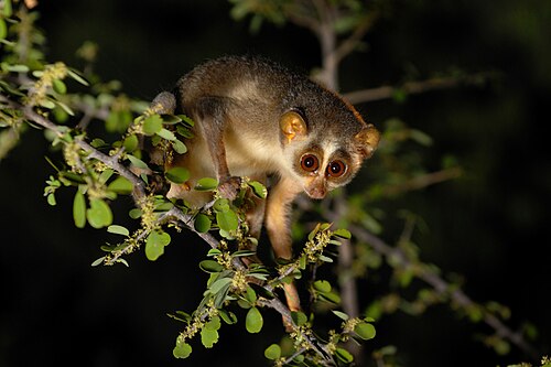
この地域に生息する哺乳類には、ベンガルトラ、ヒョウ、ナマケグマ、インドノイヌ、キンイロジャッカル、インドギツネ、そしてジャングルキャット、スナドリネコ、ベンガルヤマネコなどのネコ科動物が含まれます。大型草食動物には、インドゾウ、ブラックバック、サンバー、マダラジカ、ホエジカ、インドガゼル、ヨツヅノレイヨウ、インドバイソン、イノシシ、インドタテガミヤマアラシ、マメジカ、ニルガイが含まれます。その他の小型哺乳類には、ハイイロホオジロロリス、インドノウサギ、インドハリネズミ、インドマングース、モグラネズミ、カワウソ、インドセンザンコウ、パームシベット、インドオオモモンガ、マドラスツパイが含まれます。[ 14 ]: 43ボンネットモンキー、アカゲザル、ハヌマンラングールが主な霊長類である。この地域には15種以上のコウモリも生息している。[ 14 ]: 44
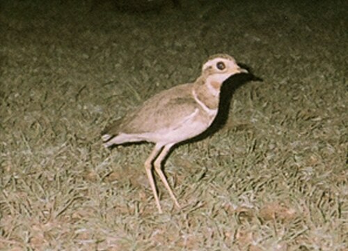
Bird surveys have found about 425 species belonging to 57 families in the region. Four species of hornbills are found in the region and are considered keystone species.[14]:50[26] The Jerdon's courser was thought to be extinct in the wild before it was re-discovered in the range in 1986. More than 50% of the wild population of the critically endangeredIndian bustard is found in the region.[14]:53 Common and widespread species include the red-vented bulbul, white-browed bulbul, red-whiskered bulbul, common iora, and purple-rumped sunbird. Five species of birds that are endemic to the Western Ghats region have been sighted in the fringes of the Eastern Ghats. These include grey-headed bulbul, Nilgiri wood pigeon, Malabar parakeet, crimson-backed sunbird, and rufous babbler. Other species of avifauna include laughing dove, Indian nightjar, jungle owlet, red avadavat, Malayan night heron, striated heron, white-naped woodpecker, savanna nightjar, brown hawk-owl, Nilgiri flowerpecker, spot-bellied eagle-owl, blue-eared kingfisher, green imperial pigeon, oriental dwarf kingfisher, Indian swiftlet, and white-browed fantail. Raptors included white-eyed buzzard, grey-headed fish eagle, lesser fish eagle.[27][28] Two species of critically endangeredvultures–Indian vulture and red-headed vulture have been reported in the region.[29][30]
この地域には約 99 種の爬虫類が生息しています。これには、インドオオトカゲや、イェルカウドスレンダーヤモリ、穴掘り肢なしスキンク、東ガーツ斑点スキンク、マドラス斑点スキンクなどの固有種が含まれます。インドゴールデンヤモリとジェイプールグラウンドヤモリは、それぞれ 1986 年と 2010 年に再発見されました。[ 14 ] : 49 [ 31 ]その他の爬虫類には、ヤモリ、スキンク、トカゲ、イグアナ、カメレオン、オオトカゲが含まれます。ヘビには、盲ヘビ、盾尾ヘビ、サンドボア、コブラ、クサリヘビ、アマガサヘビ、サンゴヘビ、ニシキヘビが含まれます。この地域には、ヒキガエル、イシガエル、コオロギガエル、ウシガエル、アナホリガエル、フウロガエル、コガエル、アマガエル、キンイロガエルなど、約100種の両生類が生息している。[ 32 ]また、この地域の水域には、28科に属する約155種の淡水魚が生息している。昆虫類には、約150種のチョウや9種のタランチュラなどが含まれる。[ 14 ] : 51
A 2017 study indicated that the Eastern Ghats region has lost about 32,200 km2 (12,400 sq mi) forest cover between 1920 and 2015. Forests which occupied 43.5% of the land area reduced by nearly 16 percent.[14]:119 An estimated 7.92 percent of the forest area converted for agriculture and 3.80 percent to grasslands from 1920 to 2015. As of 2018, only 3.53 percent of the total area was declared as protected areas.[13] The major threats included illegal logging, mining, grazing, agriculture, forest fires and tourism, poaching, and illegal tapping of forest resources which have resulted in deforestation and fragmentation of forests.[12][13] Various natural disasters such as heavy rainfalls, extreme temperature, environmental changes, competition due to invasive species have been threats to the biodiversity in the region. The absence of pollinators have also had an effect on the natural regeneration of vegetation.[12]

Till 1980, logging was a major contributor for the loss of forest cover with decrease in tree species such as teak, sal, red sanders, and sandalwood. Though laws in 1988 curtailed illegal logging, wood is still quarried by people for making charcoal, firewood, and construction.[14]:91 Forest produce is a source of income for people living in the fringes of the ranges. Over harvesting of forest produce for fodder, traditional medicine, and domestic uses along with unscientific extraction methods and burning of forests have been threats.[14]:92 The introduction of alien species either by deliberate or non deliberate means have resulted in competition to native species.[14]:93 The construction of large dams across rivers in the region have submerged more than 2,300 km2 (890 sq mi) of forest cover.[14]:94

The Eastern Ghats region is rich in minerals and semi-precious stones. Illegal mining, poor mining processes, over exploitation, and unsafe disposal of debris have resulted in issues bio-degeneration of the areas.[14]:98–99 Eight of the 29 forest fire prone districts are located in the region and, Odisha and Andhra Pradesh recorded the most forest fires in 2014. With more than 90% of these fires caused by humans, this has resulted in loss of forest cover.[14]:101 Practices such as shifting cultivation, plantations, and illegal encroachments are the major agricultural contributors to deforestation.[14]:103, 107 Increased urbanisation, and expansion of cities, construction of roads and railways, and tourism have led to encroachments into forest lands, and threats to bio-diversity in the region.[14]:112, 114
The Government of India had enacted various policies over the years to address the environmental concerns, access to forest resources, and protection of wildlife.[14]:140 Three national parks, two biosphere reserves, and 22 wildlife sanctuaries are present in the Eastern Ghats region. The protected areas include five tiger reserves under the Project Tiger, and an elephant reserve under the Project Elephant protection plans. About 13 eco-sensitive zones have been declared, which are jointly managed with the local communities.[14]:144–146


{{cite web}}: CS1メンテナンス: アーカイブサービスは非推奨になりました (リンク)