Loading article…
| セントヘレンズ山 | |
|---|---|
 1980年の大噴火から2年後の1982年5月19日、高さ3,000フィート(0.9 km)の蒸気の噴煙が上がった。 | |
| 最高点 | |
| 標高 | 8,363 フィート (2,549 メートル) |
| プロミネンス | 4,605 フィート (1,404 メートル) |
| リスト |
|
| 座標 | 北緯46度11分28秒 西経122度11分40秒 / 北緯46.1912000度 西経122.1944000度 / 46.1912000; -122.1944000 [1] |
| ネーミング | |
| 語源 | 初代セントヘレンズ男爵アレイン・フィッツハーバート |
| ネイティブ名 | |
| 地理 | |
  セントヘレンズ山 ワシントン州内の場所 | |
| 親範囲 | カスケード山脈 |
| 地形図 | USGSセントヘレンズ山 |
| 地質学 | |
| ロックの時代 | 4万年未満 |
| 山型 | 活成層火山(沈み込み帯) |
| 火山弧 | カスケード火山弧 |
| 最後の噴火 | 2004–2008 |
| クライミング | |
| 初登頂 | 1853年、トーマス・J・ドライアー |
| 最も簡単なルート | 火山の南斜面(噴火現場に最も近いエリア)をハイキング |
セント・ヘレンズ山( 先住民族のカウリッツ族からはラウェトラトラ、クリッキタット族からはルーウィットまたはルーワラ・クラフと呼ばれている)は、アメリカ合衆国の太平洋岸北西部のワシントン州スカマニア郡[1]に位置する活成層火山である。オレゴン州ポートランドの北東52マイル(83 km) [2] 、シアトルの南98マイル(158 km)に位置している。[3]セント・ヘレンズ山の英語名は、 18世紀後半にこの地域を調査した探検家ジョージ・バンクーバーの友人で、イギリスの外交官で初代セント・ヘレンズ男爵のアレイン・フィッツハーバートに由来している。[1]この火山は、太平洋火山帯の一部であるカスケード火山弧の一部である。
1980年5月18日のセントヘレンズ山の大噴火は、米国史上最悪の死者と経済破壊をもたらした火山活動として今も記憶されている。[4] 57人が死亡、200軒の家屋、47の橋、15マイル(24 km)の鉄道、185マイル(298 km)の高速道路が破壊された。[5]マグニチュード5.1の地震によって引き起こされた大規模な岩屑なだれが側噴火を 引き起こし[6]、山頂の標高が9,677フィートから8,363フィート(2,950~2,549 m)に低下し、幅1マイル(1.6 km)の馬蹄形の火口が残った。[7]岩屑なだれの体積は0.6立方マイル(2.5 km 3 )であった。[8] 1980年の噴火は火山付近の陸上生態系を破壊した。対照的に、この地域の水生生態系は大量の灰から大きな恩恵を受け、生物が急速に増殖した。噴火から6年後、この地域のほとんどの湖は通常の状態に戻った。[9]
1980年の噴火後、この火山は2008年まで継続的な火山活動を経験した。地質学者は、溶岩ドームの形状上、噴火にはより大きな圧力が必要となるため、将来の噴火はより破壊的なものになると予測している。[10]しかし、セントヘレンズ山は人気のハイキングスポットであり、一年中登山者がいる。1982年、セントヘレンズ山国立火山記念碑がロナルド・レーガン大統領 と米国議会によって設立された。
地理的設定と説明
一般的な

セントヘレンズ山は、カスケード山脈の西部にあるアダムス山の西34マイル(55 km)に位置しています。兄弟山と姉妹山とみなされているこの2つの火山は、カスケード山脈の最高峰であるレーニア山から約50マイル(80 km)離れています。オレゴン州で最も近い主要な火山であるフッド山は、セントヘレンズ山の南東60マイル(100 km)に位置しています。
セントヘレンズ山は、他の主要なカスケード山脈の火山に比べると地質学的に新しい。この火山は過去4万年以内に形成されたばかりで、1980年の噴火前に存在していた山頂の円錐丘は約2200年前に隆起し始めた。[11]この火山は、過去約1万年にわたる完新世において、カスケード山脈で最も活発な火山であると考えられている。[ 12 ]
1980 年の噴火以前、セントヘレンズ山はワシントン州で 5 番目に高い山だった。1980 年以前の山頂円錐丘の対称性と広範囲にわたる雪と氷の覆いにより、周囲の丘陵から際立って目立っていたため、「アメリカの富士山」というニックネームが付けられた。 [13] : 201 1980 年の噴火直前の氷には、ウィッシュボーン、ルーウィット、レスチ、フォーサイス、ネルソン、エイプ、シューストリング、スウィフト、ドライヤー、トゥール、タルスという 11 の氷河が含まれていた。この 11 の氷河のうち、シューストリング氷河だけが噴火後にいくらか復活した。[14]山頂は、下部の斜面が隣接する尾根と合流する基部より 5,000 フィート (1,500 メートル) 以上も隆起していた。この山は麓の直径が6マイル(9.7 km)あり、北東側は標高4,400フィート(1,300 m)、その他の場所は標高4,000フィート(1,200 m)である。噴火前の森林限界では、円錐形の幅は4マイル(6.4 km)であった。
火山に源を発する小川は、北と北西のトゥール川、西のカラマ川、南と東のルイス川の 3 つの主要な水系に流れ込みます。小川は豊富な雨と雪によって水が供給されます。年間平均降雨量は 140 インチ (360 cm) で、山の上部斜面の積雪は 16 フィート (4.9 m) に達することがあります。ルイス川は水力発電のために3 つのダムに堰き止められています。火山の南側と東側は、火山の頂上の真南にある上流の貯水池、スウィフト貯水池に流れ込みます。
セントヘレンズ山はワシントン州スカマニア郡にあるが、山へのアクセスルートは西はカウリッツ郡、北はルイス郡を通っている。地元ではスピリットレイク記念ハイウェイとして知られる州道504号線は、山の西34マイル (55 km) の出口49で州間高速道路5号線と接続している。[15] : 297 この南北のハイウェイは、カウリッツ川沿いの低地にあるキャッスルロック、ロングビュー、ケルソーの都市を迂回し、南西50マイル (80 km) 未満のワシントン州バンクーバーとオレゴン州ポートランドの都市圏を通過している。 火山に最も近いコミュニティは、山頂から南南西11マイル (18 km) のルイス川渓谷にあるワシントン州クーガーである。
クレーター氷河とその他の新しい岩石氷河
1980年から1981年の冬、新しい氷河が出現した。現在、正式にはクレーター氷河と名付けられているこの氷河は、以前はトゥルトソン氷河として知られていた。火口壁の影に隠れ、大雪と度重なる雪崩に支えられ、急速に成長した(厚さは年間14フィート(4.3メートル)。2004年までに、約0.36平方マイル(0.93 km 2)を覆い、ドームによって西側と東側のローブに分割された。通常、夏の終わりまでには、氷河は火口壁からの落石と噴火による灰で黒く見える。2006年の時点で、氷の平均厚さは300フィート(100メートル)、最大650フィート(200メートル)で、はるかに古くて大きいレーニア山のカーボン氷河とほぼ同じ深さだった。氷はすべて1980年以降にできたもので、地質学的には非常に新しい氷河である。しかし、新しい氷河の体積は1980年以前のすべての氷河を合わせた体積とほぼ同じです。[16] [17] [18] [19] [20]
2004年から、火山活動により氷河ローブが押しのけられ、新しい火山ドームの成長によって上方に押し上げられました。かつてはほとんどクレバスがなかった氷河の表面は、火口底の動きによって生じたクレバスとセラックが縦横に交差する氷瀑の混沌とした混乱に変わりました。 [21]新しいドームは、クレーター氷河を東ローブと西ローブにほぼ分離しました。火山活動にもかかわらず、氷河の末端は依然として前進しており、西ローブはわずかに前進し、より日陰になっている東ローブはより大幅に前進しました。前進により、2008年5月下旬に氷河の2つのローブが結合し、氷河が溶岩ドームを完全に取り囲むようになりました。[21] [22] [23]さらに、2004年以来、クレーター氷河の上部の火口壁に新しい氷河が形成され、その下の表面に岩石と氷が供給されています。クレーター氷河の東側のローブの北には2つの岩石氷河があります。[24]
気候
地質学
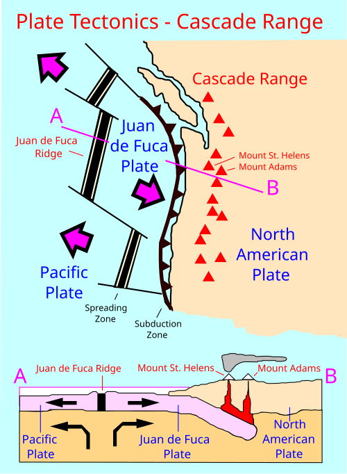
セントヘレンズ山はカスケード火山区の一部で、ブリティッシュコロンビア州南西部からカリフォルニア州北部まで、太平洋沿岸とほぼ平行に弧を描く帯状の地域である。[26]カスケード火山区の下では、高密度の海洋プレートが北米プレートの下に沈み込む。このプロセスは地質学では沈み込みと呼ばれる。海洋プレートが大陸プレートの下の地球内部に深く沈み込むと、高温高圧により、固い岩石の鉱物に閉じ込められた水分子が逃げ出す。超臨界水は沈み込むプレートの上にある柔軟なマントルに上昇し、マントルの一部が溶ける。この新しく形成されたマグマは、亀裂や断層、および溶融岩石の両方を経由して、抵抗が最も少ない経路に沿って地殻を通って上昇する。溶けた地殻が加わることで、地球化学的組成が変化する。[27]
マントルからのマグマは火山の下の2つのマグマ溜まりに蓄積しており、1つは地表から約3〜7マイル(5〜12 km)下、もう1つは約7〜25マイル(12〜40 km)下にあります。[28]下側のマグマ溜まりはアダムズ山やインディアン・ヘブン火山地帯と共有されている可能性があります。[29]
噴火活動の祖先段階
セントヘレンズ山の初期の噴火段階は、「エイプキャニオン段階」(約4万~3万5千年前)、「クーガー段階」(約2万~1万8千年前)、「スウィフトクリーク段階」(約1万3千~8千年前)として知られています。[30]紀元前2500年頃からの現代は「スピリットレイク段階」と呼ばれています。スピリットレイク以前の段階は総称して「祖先段階」と呼ばれています。祖先段階と現代段階は、噴出した溶岩の組成が主に異なります。祖先溶岩はデイサイトと安山岩の特徴的な混合物で構成されていましたが、現代の溶岩は非常に多様です(オリビン 玄武岩から安山岩、デイサイトまで)。[13] : 214
セントヘレンズ山は、37,600年前の更新世、エイプキャニオン期に、高温の軽石と灰を伴ったデイサイトと安山岩の噴火とともに成長し始めました。 [13] : 214 36,000年前、大規模な泥流が火山を流れ落ちました。 [13] : 214 泥流はセントヘレンズ山のすべての噴火サイクルにおいて大きな力でした。エイプキャニオンの噴火期は約35,000年前に終了し、その後17,000年間は比較的静かでした。この祖先の円錐丘の一部は、現在の氷河期の最後の氷河期である14,000~18,000年前に氷河によって断片化され、運ばれました。[13] : 214
2回目の噴火期であるクーガーステージは2万年前に始まり、2千年間続いた。[13] : 214 この期間中、熱い軽石と灰の火砕流とドームの成長が発生した。さらに5千年間の休眠状態が続いたが、火砕流、ドームの成長、火山灰による田園地帯の覆いに特徴づけられるスイフトクリーク噴火期の始まりによって混乱させられた。スイフトクリークは8千年前に終わった。
スミスクリークとパインクリークの噴火期間
約4,000年の休眠状態が紀元前2500年頃にスミスクリーク噴火期の始まりとともに破られ、大量の灰と黄褐色の軽石が数千平方マイルを覆った。[13] : 215 紀元前1900年の噴火は、完新世のセントヘレンズ山で起きた最大の噴火として知られ、Ynテフラを堆積させた。[13] : 215 [31]この噴火期は紀元前1600年頃まで続き、現在のマウント・レーニア国立公園に50マイル (80 km) 離れた場所に18インチ (46 cm) の深さの堆積物を残しました。痕跡堆積物は北東ではアルバータ州のバンフ国立公園、南東ではオレゴン州東部まで見つかっています。[13] : 215 このサイクルで放出された物質は合計で2.5立方マイル(10 km 3 )にも達した可能性がある。 [13] : 215 その後約400年間の休眠状態が続いた。
セントヘレンズ山は紀元前1200年頃、パインクリーク噴火期に再び活気づいた。[13] : 215 この噴火は紀元前800年頃まで続き、小規模な噴火が特徴であった。多数の濃密でほぼ赤熱した火砕流がセントヘレンズ山の斜面を流れ下り、近くの谷に流れ着いた。紀元前1000年から紀元前500年の間には、大規模な泥流がルイス川渓谷の40マイル(64 km)を部分的に埋めた。
キャッスルクリークとシュガーボウルの噴火期間

次の噴火期であるキャッスルクリーク期は紀元前400年頃に始まり、セントヘレンズ山の溶岩の組成が変化し、カンラン石と玄武岩が追加されたのが特徴です。[13] : 216 1980年以前の山頂円錐丘はキャッスルクリーク期に形成され始めました。この時期の特徴は、それ以前にははるかに一般的だった断片化および粉砕された溶岩と岩(テフラ)に加えて、かなりの量の溶岩流でした。安山岩と玄武岩の大きな溶岩流が山の一部を覆い、紀元前100年頃にはルイス川とカラマ川の渓谷まで流れ込んだものもありました。[13] : 216 ケーブバサルト(溶岩洞のシステムで知られる)などの他の溶岩は、火口から最大9マイル(14 km)まで流れました。[13] : 216 1世紀の間に、泥流はトゥール川とカラマ川の渓谷を30マイル(50 km)下ってコロンビア川に達した可能性があります。その後、さらに400年間の休眠状態が続きました。
シュガーボウルの噴火期間は短く、セントヘレンズ山の歴史における他の期間とは著しく異なっていた。1980年の噴火以前にセントヘレンズ山で知られている唯一の明白な横方向の爆発が発生した。[32]シュガーボウルの期間中、火山は最初に静かに噴火してドームを形成し、その後少なくとも2回激しく噴火し、少量の火山灰、方向性のある爆発堆積物、火砕流、ラハールが発生した。[32]火山の東斜面にある小さな紫水晶-半閃石デイサイトドームであるイーストドームは、シュガーボウルの時期に形成された可能性が高い。[33]イーストドームの形成に先立って爆発的な噴火があった。[34]
カラマとゴートロックスの噴火期間
.jpg/500px-1890_Clohessy_and_Strengele_engraving_of_Mount_St_Helens_(cropped).jpg)
およそ700年間の休眠状態が1480年頃に破られ、淡い灰色のデイサイトの軽石と灰が大量に噴出し、カラマ期が始まった。1480年の噴火は1980年5月18日の噴火より数倍も大きかった。 [32] 1482年には、1980年の噴火に匹敵する規模の別の大噴火が発生したことが知られている。[32]灰と軽石は火山の北東6マイル(9.7km)に3フィート(0.9m)の厚さに積もり、50マイル(80km)離れたところでは灰の厚さは2インチ(5cm)だった。その後、大規模な火砕流と泥流がセントヘレンズ山の西側斜面を流れ下り、カラマ川の流域に流れ込んだ。
次にこの150年間に、シリカの含有量が少ない溶岩が安山岩灰の形で噴火し、少なくとも8つの明るい色と暗い色が交互になった層を形成した。[13] : 216 ブロック状の安山岩溶岩がセントヘレンズ山の山頂火口から火山の南東斜面を流れ下った。[13] : 216 その後、火砕流が安山岩溶岩の上を流れ下り、カラマ川渓谷に流れ込んだ。その結果、数百フィート (約 200 メートル) の高さのデイサイトドームが火山の山頂に定着し、山頂に既にあった爆発火口を埋め尽くして溢れ出た。[13] : 217 ドームの側面の大部分が崩れ、火山の円錐形の一部を崖錐で覆った。側方爆発によって南東の火口壁に切り込みが入った。セントヘレンズ山は、カラマ火山の噴火サイクルが終了した1647年頃に最高標高に達し、高度に対称的な形状を獲得しました。 [13] : 217 その後150年間、火山は静穏状態を保っていました。
1800年に始まった57年間の噴火期間はゴート ロックス ドームにちなんで名付けられ、口承と文書による記録が残っている最初の期間です。[13] : 217 カラマ期間と同様に、ゴート ロックス期間はデイサイト テフラの爆発で始まり、続いて安山岩の溶岩流が流れ、デイサイト ドームの定置で最高潮に達しました。1800年の噴火は規模ではおそらく1980年の噴火に匹敵しますが、円錐丘の大規模な破壊には至りませんでした。灰はワシントン州中部と東部、アイダホ州北部、モンタナ州西部を北東に漂いました。 1831年から1857年にかけて、1842年のかなり大規模な噴火を含め、少なくとも12回の小規模な火山灰噴火が報告されている。(8月13日の午後、バージニア州サウサンプトン郡で太陽が青緑色に染まったのは、おそらく1831年の噴火によるもので、ナット・ターナーはこれを米国最大の奴隷反乱を開始する最後の合図と解釈した。[ 35 ] )噴火口は、明らかに北東斜面のゴート・ロックスかその付近にあった。[13] : 217 ゴート・ロックス・ドームは1980年の噴火で隆起した場所の近くにあり、1980年5月18日の大噴火で消滅した。大噴火では、山の北面全体と頂上1,300フィート (400 m) が破壊された。
現代の噴火期
.jpg/500px-MSH-10B_Mount_St._Helens_Erupts,_Portland_View,_May_18,_1980_(22636191326).jpg)

1980年から2001年の活動
1980年3月20日、セント・ヘレンズ山はマグニチュード 4.2の地震に見舞われ[4]、3月27日には水蒸気の噴出が始まった[36]。4月末までには、山の北側が隆起し始めた[37] 。 5月18日、マグニチュード5.1の2度目の地震が山の北面の大規模な崩壊を引き起こした。これは記録に残る史上最大の岩屑なだれであった。セント・ヘレンズ山のマグマは大規模な火砕流となって噴出し、230平方マイル(600 km 2 )の面積にわたって植生や建物をなぎ倒した。150万トンを超える二酸化硫黄が大気中に放出された[38] 。この噴火は火山爆発指数スケールで5と評価され、プリニー式噴火に分類された。
セントヘレンズ山の北側斜面の崩壊により氷、雪、水が混ざり合ってラハール(火山泥流)が生じた。ラハールはトゥートル川とカウリッツ川を何マイルも流れ、橋や木材集積所を破壊した。泥流によって合計390万立方ヤード(300万m 3 )の土砂が南のコロンビア川に17マイル(27km)運ばれた。[13] : 209
9時間以上にわたって激しい灰の噴煙が上がり、最終的に海抜12~16マイル(19~26km)に達した。[39]噴煙は平均時速60マイル(100km/h)で東に移動し、灰は正午までにアイダホ州に到達した。翌朝、噴火による灰は遠くカナダのアルバータ州エドモントンまで車や屋根の上に付着しているのが発見された。
5月18日午後5時30分頃までには、垂直に上がった灰の柱の高さは低下し、それほど激しくない噴火が夜通し、その後数日間にわたって続いた。セント・ヘレンズ山の5月18日の噴火では、24メガトンの熱エネルギーが放出され[6] [40] 、0.67立方マイル (2.79 km 3 ) を超える物質が噴出した。[6]山の北側が削り取られたことにより、セント・ヘレンズ山の高さは約1,300フィート (400 m) 低下し、幅1.2~1.8マイル (2~3 km)、深さ2,084フィート (635 m) のクレーターが残り、その北端は大きく開いていた。この噴火で57人が死亡し、約7,000頭の大型動物 (シカ、ヘラジカ、クマ) が死亡[5] 200軒以上の家屋、185マイル(298 km)の高速道路、15マイル(24 km)の鉄道が破壊または甚大な被害を受けました。[5]
1980年から1986年にかけて、セントヘレンズ山の活動は続き、火口に新たな溶岩ドームが形成されました。多数の小規模な爆発とドーム形成噴火が発生しました。1989年12月7日から1990年1月6日まで、および1990年11月5日から1991年2月14日まで、山は噴火し、時には巨大な灰の雲が立ち上りました。[41]
2004年から2008年の活動
.jpg/500px-Whaleback,_Mount_St_Helens_volcanic_crater_(February_22_2005).jpg)
2004年10月11日頃、マグマが火山の表面に到達し、既存のドームの南側に新しい溶岩ドームが形成された。この新しいドームは2005年から2006年にかけて成長を続けた。「ホエールバック」と呼ばれる溶岩の背骨など、いくつかの一時的な特徴が観察された。これは、下のマグマの圧力によって押し出された、固まったマグマの長い軸で構成されていた。これらの特徴は脆弱で、形成されてすぐに崩壊した。2005年7月2日、ホエールバックの先端が折れ、岩が崩れ、灰と塵が数百メートル上空まで吹き上がった。[42]
セントヘレンズ山は2005年3月8日に顕著な活動を見せ、高さ36,000フィート(11,000メートル)の蒸気と灰の噴煙がシアトルから見えるほど上昇した。[43]この比較的小規模な噴火は、進行中のドーム形成に伴う圧力の解放であった。この噴火はマグニチュード2.5の地震を伴っていた。
ドームから現れたもう一つの特徴は「フィン」または「スラブ」と呼ばれていた。フットボール競技場の約半分の大きさで、冷却された大きな火山岩は、1日あたり6フィート(2メートル)もの速さで押し上げられていた。[44] [45] 2006年6月中旬、スラブは頻繁な落石で崩れ始めたが、まだ押し上げられ続けていた。ドームの高さは7,550フィート(2,300メートル)で、2005年7月にホエールバックが崩壊したときの高さよりまだ低かった。
2006 年 10 月 22 日午後 3 時 13 分 (太平洋標準時)、マグニチュード 3.5 の地震がスパイン 7 を崩壊させました。溶岩ドームの崩壊と雪崩により、火口の西側の縁から 2,000 フィート (600 メートル) の高さまで火山灰の噴煙が上がりましたが、その後、火山灰の噴煙は急速に消散しました。
2006年12月19日、凝縮した蒸気の大きな白い噴煙が観測され、一部のメディアは小規模な噴火があったと推測した。しかし、 USGSのカスケード火山観測所は、目立った火山灰の噴煙については言及しなかった。[46]火山は2004年10月から継続的に噴火していたが、この噴火の大部分は、火口にドームを形成する溶岩の緩やかな噴出であった。
2008年1月16日、溶岩ドームの頂上の亀裂から蒸気が漏れ始めました。関連する地震活動は2004年以来最も注目に値するものでした。科学者は火口と山腹での活動を中止しましたが、大規模な噴火のリスクは低いと判断されました。[47] 1月末までに噴火は停止し、溶岩ドームからの溶岩の噴出はなくなりました。2008年7月10日、6か月以上火山活動がなかった後、噴火は終了したと判断されました。[48]
将来の危険

セントヘレンズ山の今後の噴火は、1980年の噴火よりもさらに大規模になる可能性が高い。[15] : 296 火口内の現在の溶岩ドームの配置は、次の噴火には非常に大きな圧力が必要になることを意味しており、したがって破壊のレベルも高くなるだろう。[15] : 296 大量の降灰が40,000平方マイル(100,000 km 2)に広がり、交通を混乱させる可能性がある。 [15] : 296 トゥール川の支流では大規模なラハールが発生する可能性があり、 I-5回廊沿いの居住地域で破壊を引き起こす可能性がある。[49]
エコロジー

セントヘレンズ山の斜面は、手つかずの状態では、西カスケード山脈高地生態地域に位置している。[50]この生態地域は降水量が豊富で、スピリット湖では毎年平均 93.4 インチ (2,373 mm) の降水量がある。[51]この降水量により、標高 5,200 フィート (1,600 m) までの密林が育ち、ウェスタンツガ、ダグラスモミ、ウェスタンレッドシダーが生い茂っている。この森林より上の標高4,300 フィート (1,300 m) までは、太平洋シルバーモミが優勢だった。最後に、森林限界より下では、森林はマウンテンツガ、太平洋シルバーモミ、アラスカイエローシダーで構成されていた。[51]大型哺乳類には、ルーズベルトヘラジカ、オグロジカ、アメリカクロクマ、マウンテンライオンなどがいた。[51]
セントヘレンズ山の森林限界は、噴火前に森林限界が斜面を上っていったと考えられていたため、以前の火山活動による森林の撹乱の結果、約4,400フィート(1,340メートル)と異常に低かった。[51]セントヘレンズ山では高山草原は珍しい。[51]シロイワヤギは山頂のより高い標高に生息していたが、1980年の噴火でその個体数は絶滅した。[52]
噴火による生態系の混乱
セントヘレンズ山の噴火は、噴火直後から撹乱に関する研究が開始され、噴火によって周辺地域が不毛化しなかったことから、他のどの噴火よりも多くの生態学的研究の対象となった。火山噴火に対する生態学的反応に関する論文の半分以上は、セントヘレンズ山の研究から生まれたものである。[53]
おそらく、セントヘレンズ山の研究から生まれた最も重要な生態学的概念は、生物学的遺産です。[54]生物学的遺産は、壊滅的な撹乱の生存者であり、生きているもの(例えば、火山灰や火砕流を生き延びた植物)、有機物の残骸、または撹乱前から残っている生物パターンのいずれかです。[55]これらの生物学的遺産は、撹乱後の生態系の再構築に大きな影響を与えます。[54] [56]
各栄養段階のいくつかの種は1980年の噴火を生き延び、食物連鎖の比較的早い再構築を可能にした。[57]大型種の死亡率は高く、[57]その地域の大型哺乳類(シロイワヤギ、ヘラジカ、シカ、アメリカクロクマ、クーガー)は完全に死滅した。[58]最終的に、大型哺乳類はすべてその地域に戻って来た。[59]適切な飼料が得られなかったため、その後の数十年間、多くのヘラジカが冬に餓死した。[60] 2014年までに、シロイワヤギの個体数は65頭にまで回復した。 2015年には152頭にまで増えた。[61]シロイワヤギはカウリッツ族にとって文化的に重要な存在であり、同族は歴史的に山に残されたヤギの毛の房を収穫してきた。[61]また、同族は個体数の監視に役割を果たしており、個体数は人間の介入なしに回復し続けている。[62]
人類の歴史

先住民族にとっての重要性
ネイティブアメリカンの伝承には、セントヘレンズ山やカスケード山脈の他の火山の噴火を説明する物語が数多くあります。その中で最もよく知られているのは、クリッキタット族が語る「神々の橋」の物語です。
物語では、すべての神々の長と彼の二人の息子、パト(クリッキタットとも呼ばれる)とワイイーストが、定住するのに適した地域を探して極北からコロンビア川を下って旅をしました。 [63]
彼らは現在ザ・ダレスと呼ばれる地域にたどり着き、これほど美しい土地は見たことがないと思った。息子たちはその土地をめぐって口論したので、その争いを解決するために父親は強力な弓から2本の矢を放った。1本は北へ、もう1本は南へ。パトは矢を追って北へ行き、そこに定住し、ワイイーストも矢を追って南へ行った。その後、神々の長は神々の橋を建設し、家族が定期的に集まることができるようにした。[63]
神々の長の二人の息子がルーウィットという名の美しい乙女に恋をしたとき、彼女は二人のどちらかを選ぶことができませんでした。二人の若い長は彼女をめぐって争い、その過程で村や森が埋もれました。その地域は荒廃し、地面が激しく揺れたため、巨大な橋が川に落ち、コロンビア川渓谷の滝ができました。[64]
罰として、神々の長は恋人たちを一人一人打ち倒し、彼らが落ちた場所を巨大な山に変えた。誇らしげに頭を上げたワイイーストは、今日ではマウント・フッドとして知られる火山となった。恋に落ちた人に向かって頭を下げたパトは、アダムス山となった。美しいルーウィットはセント・ヘレンズ山となり、クリッキタット族にはルーワラ・クロフとして知られ、彼らの言語で「煙を上げる山、または火の山」を意味する(サハプティン族は山をルーウィットと呼ぶ)。[65]
この山は、この地域に住むカウリッツ族とヤカマ族にとっても神聖な場所である。彼らは、この山の樹木限界線より上の地域を非常に精神的に重要な場所とみなしており、この山(彼らは「煙を吐く人」と大まかに訳して「ラウェトララ」と呼ぶ)は、彼らの創造物語や、彼らの歌や儀式のいくつかで重要な位置を占めている。[66]この山の文化的重要性を認識し、12,000エーカー(4,900ヘクタール)を超える地域(ルーウィット・トレイルでほぼ区切られている)が国家歴史登録財に登録されている。[67]
この山の他の地域部族名には、アッパー・チェハリス語の「nšh'ák'w」(「水が湧き出る」)やキクシュト語の「aka akn」(「雪山」)などがある。[67]
ヨーロッパ人による探検

.jpg/500px-The_Town_Crier,_v.12,_no.33,_Aug._18,_1917_-_DPLA_-_de44e160705c9a8bd082814fa232922c_(page_1).jpg)
1792年5月19日、イギリス海軍のジョージ・バンクーバー司令官とディスカバリー号の士官らが北太平洋沿岸の調査中に、ヨーロッパ人として初めてセント・ヘレンズ山を目撃した。バンクーバーは1792年10月20日、[65] [68]ディスカバリー号がコロンビア川の河口を通過した際にこの山が見えたため、イギリスの外交官アレイン・フィッツハーバート初代セント・ヘレンズ男爵にちなんでこの山に名前を付けた。
数年後、探検家、貿易商、宣教師らは、この地域で火山が噴火したという報告を耳にした。地質学者や歴史家らは、ずっと後になって、噴火は1800年に起こり、57年間続いたゴートロックス噴火期の始まりであったと結論付けた(地質学の項を参照)。[13] : 217 ワシントン州北東部のネスペレム族は「乾いた雪」に驚いて、食料を集める代わりに踊ったり祈ったりし、その冬は飢餓に苦しんだとされている。[13] : 217
1805年後半から1806年初頭にかけて、ルイス・クラーク探検隊のメンバーはコロンビア川からセントヘレンズ山を発見したが、噴火が続いているとか、噴火の兆候が最近あったとかは報告しなかった。[69]しかし、ポートランド近郊のサンディ川の河口に流砂と水路の詰まりがあったと報告しており、過去数十年の間に フッド山が噴火したことが示唆されている。
1829年、ホール・J・ケリーはカスケード山脈を大統領山脈と改名し、カスケード山脈の主要な山々をアメリカ合衆国元大統領にちなんで改名する運動を主導した。彼の計画ではセント・ヘレンズ山はワシントン山と改名される予定だった。[70]
ヨーロッパ人の植民地化とこの地域の利用

火山噴火に関する最初の非先住民による目撃証言は、1835年3月に、バンクーバー砦に駐留していたハドソン湾会社で働いていたメレディス・ガードナーによってなされた。[13] : 219 彼はエディンバラ・ニュー・フィロソフィカル・ジャーナルに報告を送り、1836年1月にその手紙が掲載された。エール大学のジェームズ・ドワイト・ダナは、米国探検隊とともに航海中に、1841年にコロンビア川の河口から静かな山頂を見た。探検隊の別のメンバーは後に、山の麓に「細胞状の玄武岩質溶岩」があったと述べている。[71]
1842年の晩秋か初冬に、近くのヨーロッパ人入植者と宣教師がいわゆる大噴火を目撃した。この小規模な噴火で大きな火山灰雲が発生し、その後15年間にわたって小規模な爆発が続いた。[13] : 220–221 この時期の噴火は水蒸気爆発であった可能性が高い。オレゴン州シャンポエグのジョサイア・パリッシュは1842年11月22日のセントヘレンズ山の噴火を目撃した。この噴火による灰は火山の南東48マイル(77km)にあるオレゴン州ザ・ダレスにまで達した可能性がある。 [12]
1843年10月、後のカリフォルニア州知事ピーター・H・バーネットは、鹿狩りの最中に溶岩か熱い灰で足と脚をひどくやけどした先住民の男性の、おそらく作り話と思われる話を語った。その話によると、負傷した男性はバンクーバー砦で治療を受けたが、当時の砦の補給管理人ナポレオン・マクギルバリーは事件について知らなかったと主張したという。[13] : 224 イギリス軍中尉ヘンリー・J・ウォーは1845年に噴火のスケッチを描き、その2年後にはカナダ人画家ポール・ケインは静かに煙を上げる山の水彩画を制作した。ウォーの作品には、山頂から3分の1ほど下った山の西側か北西側(おそらくゴートロックス)の噴火口から噴出する物質が描かれており、ケインのフィールドスケッチの1つには、ほぼ同じ場所から煙が出ている様子が描かれている。[13] : 225, 227
1857年4月17日、ワシントン州スティラクームの新聞「リパブリカン」は、「セントヘレンズ山、あるいはその南にある他の山が噴火状態にあると見られる」と報じた。[13] : 228 この噴火に伴う顕著な灰層が見られなかったことから、小規模な噴火であったことが示唆される。これは1854年以来初めて報告された火山活動であった。[13] : 228
1980 年の噴火以前、スピリット レイクでは年間を通じてレクリエーション活動を楽しむことができました。夏にはボート、水泳、キャンプ、冬にはスキーを楽しむことができました。
1980年の噴火による人類への影響

噴火により57人が死亡した。[72]噴火が日曜日ではなく伐採業者が作業していた1日後に起こっていたら、死者数はさらに多かった可能性がある。
スピリットレイクロッジを経営し、1929年から山の近くに住んでいた83歳のハリー・R・トルーマンは、地元当局の再三の嘆願にもかかわらず、差し迫った噴火の前に避難しないことを決定し、多くのメディアの注目を集めた。 [73]噴火後、彼の遺体は発見されなかった。[74]
噴火のもう1人の犠牲者は、近くのコールドウォーターリッジに駐留していた30歳の火山学者 デイビッド・A・ジョンストンだった。火砕流が彼の位置を襲う直前、ジョンストンは無線で最後の言葉を送った。「バンクーバー!バンクーバー!ここだ!」[75]ジョンストンの遺体は発見されなかった。[76]
U.S. President Jimmy Carter surveyed the damage and said, "Someone said this area looked like a moonscape. But the moon looks more like a golf course compared to what's up there."[77] A film crew, led by Seattle filmmaker Otto Seiber, was dropped by helicopter on St. Helens on May 23 to document the destruction. Their compasses, however, spun in circles and they quickly became lost. A second eruption occurred on May 25, but the crew survived and was rescued two days later by National Guard helicopter pilots. Their film, The Eruption of Mount St. Helens!, later became a popular documentary.
The eruption had negative effects beyond the immediate area of the volcano. Ashfall caused approximately $100 million of damage to agriculture downwind in Eastern Washington, equivalent to $370 million in 2023.[78][79]
The eruption also had positive impacts on society. Apple and wheat production were higher in the 1980 growing season, possibly due to ash helping to retain moisture in the soil.[80] The ash was also a source of income: it was the raw material for the artificial gemstone helenite,[81] or for ceramic glazes,[82] or sold as a tourist curio.[83]
Protection and later history
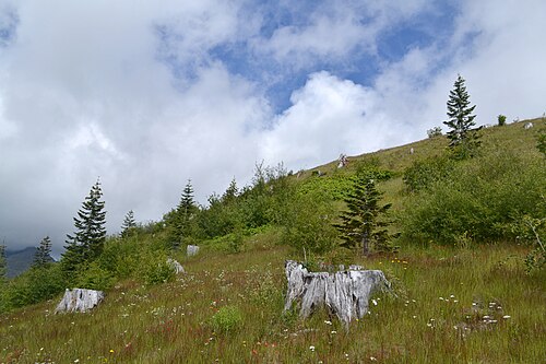
In 1982, President Ronald Reagan and the U.S. Congress established the Mount St. Helens National Volcanic Monument, a 110,000 acres (45,000 ha) area around the mountain and within the Gifford Pinchot National Forest.[84]
Following the 1980 eruption, the area was left to gradually return to its natural state. In 1987, the U.S. Forest Service reopened the mountain to climbing. It remained open until 2004 when renewed activity caused the closure of the area around the mountain (see Geological history section above for more details). The Monitor Ridge trail, which previously let up to 100 permitted hikers per day climb to the summit, ceased operation. On July 21, 2006, the mountain was again opened to climbers.[85] In February 2010, a climber died after falling from the rim into the crater.[86]
Due to the eruption, the state recognizes the month of May as "Volcano Awareness Month" and events are held at Mt. St. Helens, or within the region, to discuss the eruption, safety concerns, and to commemorate lives lost during the natural disaster.[87]
On May 14, 2023, a mudslide and debris flow given the moniker, South Coldwater Slide by the U.S. Forest Service, destroyed the 85-foot (26 m) Spirit Lake Outlet Bridge on Washington State Route 504 and cut off access to the Johnston Ridge Observatory. Closures and access to Coldwater Lake and hiking trails would vary in the month after the slide.[88][89][90]
Climbing and recreation
Mount St. Helens is a common climbing destination for both beginning and experienced mountaineers. The peak is climbed year-round, although it is more often climbed from late spring through early fall. All routes include sections of steep, rugged terrain.[91] A permit system has been in place for climbers since 1987. A climbing permit is required year-round for anyone who will be above 4,800 feet (1,500 m) on the slopes of Mount St. Helens.[92]
The standard hiking/mountaineering route in the warmer months is the Monitor Ridge Route, which starts at the Climbers Bivouac. This is the most crowded route to the summit in the summer and gains about 4,600 feet (1,400 m) in approximately 5 miles (8 km) to reach the crater rim.[93] Although strenuous, it is considered a non-technical climb that involves some scrambling. Most climbers complete the round trip in 7 to 12 hours.[94]
The Worm Flows Route is considered the standard winter route on Mount St. Helens, as it is the most direct route to the summit. The route gains about 5,700 feet (1,700 m) in elevation over about 6 miles (10 km) from trailhead to summit but does not demand the technical climbing that some other Cascade peaks like Mount Rainier do. The route name refers to the rocky lava flows that surround the route.[95] This route can be accessed via the Marble Mountain Sno-Park and the Swift Ski Trail.[96]
The mountain is now circled by the Loowit Trail at elevations of 4,000–4,900 feet (1,200–1,500 m). The northern segment of the trail from the South Fork Toutle River on the west to Windy Pass on the east is a restricted zone where camping, biking, pets, fires, and off-trail excursions are all prohibited.[97][98]
On April 14, 2008, John Slemp, a snowmobiler from Damascus, Oregon, fell 1,500 feet into the crater after a snow cornice gave way beneath him on a trip to the volcano with his son. Despite his long fall, Slemp survived with minor injuries, and was able to walk after coming to a stop at the foot of the crater wall, where he was rescued by a mountain rescue helicopter.[99]
A visitor center run by the Washington State Parks is in Silver Lake, Washington, about 30 miles (48 km) west of Mount St. Helens.[100] Exhibits include a large model of the volcano, a seismograph, a theater program, and an outdoor natural trail.[100]

See also
References
Notes
- ^ a b c "Mount Saint Helens". Geographic Names Information System. United States Geological Survey, United States Department of the Interior.
- ^ "Distance between Portland and Mount Saint Helens". distancefromto.net. Retrieved 27 March 2021.
- ^ "Distance between Seattle and Mount Saint Helens". distancefromto.net. Retrieved 27 March 2021.
- ^ a b "Mount St. Helens National Volcanic Monument". USDA Forest Service. Archived from the original on 23 November 2006.
- ^ a b c Tilling, Robert I; Topinka, Lyn; Swanson, Donald A (1990). "Impact and Aftermath". Eruptions of Mount St. Helens: Past, Present, and Future. 1.01. USGS.
- ^ a b c "Mount St. Helens – From the 1980 eruption to 2000". United States Geological Survey. 2000. Fact Sheet 036-00. Retrieved 12 November 2006.
- ^ "May 18, 1980 eruption of Mount St. Helens". USDA Forest Service. Archived from the original on 29 May 2009.
- ^ "1980 Cataclysmic Eruption". Mount St. Helens. USGS. Retrieved 27 March 2021.
- ^ "Mount St. Helens: A Living Laboratory for Ecological Research | Pacific Northwest Research Station | PNW - US Forest Service". www.fs.usda.gov. Retrieved 1 June 2021.
- ^ Haas, Maya (18 May 2020). "Mount St. Helens isn't where it should be. Scientists may finally know why". National Geographic. Archived from the original on 3 June 2021. Retrieved 20 June 2021.
- ^ Mullineaux, D.R.; Crandell, D.R. (1981). The 1980 eruptions of Mount St. Helens, Washington (Report). United States Geological Survey. p. 3. Professional Paper 1250. Retrieved 28 October 2006.
- ^ a b "Description of Mount St. Helens". USGS. Retrieved 15 November 2006.
- ^ a b c d e f g h i j k l m n o p q r s t u v w x y z aa ab ac Harris, Stephen L. (1988). "Mount St. Helens: A living fire mountain". Fire Mountains of the West: The Cascade and Mono Lake volcanoes (1st ed.). Missoula, Montana: Mountain Press Publishing Company. pp. 201–228. ISBN 0-87842-220-X.
- ^ Phillips, William M. (October 1987). "Geologic Guide to the Monitor Ridge Climbing Route, Mount St. Helens, Washington" (PDF). Washington Geologic Newsletter. 15 (4): 3–13.
- ^ a b c d Harris, Stephen L. (2005). "Mount St. Helens: A living fire mountain". Fire Mountains of the West: The Cascade and Mono Lake volcanoes (3rd ed.). Missoula, Montana: Mountain Press Publishing Company. pp. 201–228. ISBN 0-87842-511-X.
- ^ Brugman, Melinda M.; Post, Austin (1981). Effects of volcanism on the glaciers of Mount St. Helens. United States Geological Survey (Report). p. 22. USGS Circular 850-D. Retrieved 7 March 2007.
- ^ Wiggins, Tracy B.; Hansen, Jon D.; Clark, Douglas H. (2002). "Growth and flow of a new glacier in Mount St. Helens Crater". Abstracts with Programs. 34 (5). Geological Society of America: 91.
- ^ Schilling, Steve P.; Carrara, Paul E.; Thompson, Ren A.; Iwatsubo, Eugene Y. (2004). "Posteruption glacier development within the crater of Mount St. Helens, Washington, USA". Quaternary Research. 61 (3). Elsevier Science (USA): 325–329. Bibcode:2004QuRes..61..325S. doi:10.1016/j.yqres.2003.11.002. S2CID 128528280.
- ^ McCandless, Melanie; Plummer, Mitchell; Clark, Douglas (2005). "Predictions of the growth and steady-state form of the Mount St. Helens Crater Glacier using a 2-D glacier model". Abstracts with Programs. 37 (7). Geological Society of America: 354.
- ^ Schilling, Steve P.; Ramsey, David W.; Messerich, James A.; Thompson, Ren A. (8 August 2006). "Rebuilding Mount St. Helens". USGS Scientific Investigations Map 2928. Retrieved 7 March 2007.
- ^ a b Volcano Review (PDF) (Report). US Forest Service. Archived from the original (PDF) on 26 June 2008.
- ^ Schilling, Steve (30 May 2008). MSH08 aerial: New dome from north 30 May 2008 (photo). United States Geological Survey. Archived from the original on 26 June 2008. Retrieved 7 June 2008. – Glacier is still connected south of the lava dome.
- ^ Schilling, Steve (30 May 2008). MSH08 aerial: St. Helens crater from north 30 May 2008 (photo). United States Geological Survey. Archived from the original on 26 June 2008. Retrieved 7 June 2008. – Glacier arms touch on North end of glacier.
- ^ Haugerud, R.A.; Harding, D.J.; Mark, L.E.; Zeigler, J.; Queija, V.; Johnson, S.Y. (December 2004). Lidar measurement of topographic change during the 2004 eruption of Mount St. Helens, WA. American Geophysical Union, Fall Meeting. Vol. 53. p. 1. Bibcode:2004AGUFM.V53D..01H.
- ^ "PRISM Climate Group, Oregon State University". www.prism.oregonstate.edu. Retrieved 12 January 2022.
- ^ "Pacific – Cascades Volcanic Province". Archived from the original on 23 September 2006. Retrieved 13 March 2021.
 This article incorporates text from this source, which is in the public domain.
- ^ "Pacific – Cascades Volcanic Province". Archived from the original on 24 September 2006. This article incorporates text from this source, which is in the public domain.
- ^ Hand, Eric (4 November 2015). "Deep magma chambers seen beneath Mount St. Helens". Science. doi:10.1126/science.aad7392.
- ^ McKinnon, Mika (10 November 2015). "Mount Saint Helens May Share Magma with an Entire Field of Volcanoes". Gizmodo.
- ^ "Mount St. Helens – Summary of Volcanic History". USDA Forest Service. Archived from the original on 11 October 2008.
- ^ Pallister, John S.; Clynne, Michael A.; Wright, Heather M.; Van Eaton, Alexa R.; Vallance, James W.; Sherrod, David R.; Kokelaar, B. Peter (2017). "Eruptive history". Field-Trip Guide to Mount St. Helens, Washington: An overview of the eruptive history and petrology, tephra deposits, 1980 proclastic density current deposits, and the crater. United States Department of the Interior. p. 11. ISSN 2328-0328.
{{cite book}}:|journal=ignored (help) - ^ a b c d Mullineaux, Donal R (1996). Pre-1980 tephra-fall deposits erupted from Mount St. Helens, Washington. United States Geological Survey (Report). Professional Paper 1563. Retrieved 15 November 2006.
- ^ "The Eruptive History of Mount St. Helens". Volcano World. 2 June 2017. Retrieved 2 March 2023.
- ^ "Global Volcanism Program | Image GVP-02835". volcano.si.edu. Retrieved 2 March 2023.
- ^ Breen, Patrick H. (2005). Nat Turner's revolt: rebellion and response in Southampton County, Virginia. Retrieved 21 November 2021.
- ^ "Summary of Events Leading Up to the May 18, 1980, eruption of Mount St. Helens: March 22–28". USDA Forest Service. Archived from the original on 13 November 2007.
- ^ "Summary of Events Leading Up to the May 18, 1980 Eruption of Mount St. Helens: April 26–May 2". USDA Forest Service. Archived from the original on 13 November 2007.
- ^ "Emission of sulfur dioxide gas from Mount St. Helens, 1980–1988". United States Geological Survey. 25 September 2008. Retrieved 25 March 2009.
- ^ Kiver, Eugene P; Harris, David V (1999). Geology of U.S. parklands (5th ed.). Wiley. p. 149. ISBN 978-0-471-33218-3.
- ^ "Mount St. Helens National Volcanic Monument". United States Forest Service. Archived from the original on 29 May 2009.
24 megatons thermal energy
- ^ Myers, Bobbie (1992). "Small explosions interrupt 3 year quiescence at Mount St. Helens, Washington". Earthquakes and Volcanoes. 23 (2): 58–73. Archived from the original on 30 December 2006. Retrieved 26 November 2006 – via vulcan.wr.usgs.gov.
- ^ "Before and after images". USGS. Archived from the original on 3 September 2005.
- ^ "Mount St. Helens, Washington – 'Plume in the Evening'". USGS. 8 March 2005. Archived from the original on 11 March 2005. Retrieved 15 November 2006.
- ^ "New slab growing in Mount St. Helens dome". Fox News. Archived from the original on 26 October 2012. Retrieved 6 December 2010.
- ^ "Rock Slab Growing at Mt. St. Helens Volcano". Astronomy Picture of the Day. 9 May 2006.
- ^ "In the News". Cascades Volcano Observatory. Archived from the original on 7 January 2007. Retrieved 4 January 2007.
- ^ "Small quake reported at Mount St. Helens". USA Today. 17 January 2008. Retrieved 6 December 2010.
- ^ "Mount St. Helens, Washington – Eruption 2004 to current". USGS. Archived from the original on 6 October 2008. Retrieved 6 October 2008.
- ^ https://web.archive.org/web/20210128124052/https://www.usgs.gov/volcanoes/mount-st-helens/volcanic-hazards-mount-st-helens
- ^ Pater, D; Bryce, SA; Kagan, J; et al. "Ecoregions of Western Washington and Oregon" (PDF). Environmental Protection Agency. Retrieved 26 March 2021. Color poster with map, descriptive text, summary tables, and photographs; with a Reverse side
- ^ a b c d e Swanson, FJ; Crisafulli, CM; Yamaguchi, DK (2005). "Geological and Ecological Settings of MountSt. Helens Before May 18, 1980". In Dale, VH; Swanson, FJ; Crisafulli, CM (eds.). Ecological Responses to the 1980 Eruption of Mount St. Helens (PDF). Springer. doi:10.1007/0-387-28150-9. ISBN 978-0-387-23868-5. S2CID 129738611.
- ^ Gilfillan, Jule (30 June 2017). "Counting Mountain Goats On Mount St. Helens". Oregon Public Broadcasting.
- ^ Dale, VH; Swanson, FJ; Crisafulli, CM (2005). "Disturbance, Survival, and Succession: Understanding Ecological Responses to the 1980 Eruption of Mount St. Helens". In Dale, VH; Swanson, FJ; Crisafulli, CM (eds.). Ecological Responses to the 1980 Eruption of Mount St. Helens (PDF). pp. 3–11. doi:10.1007/0-387-28150-9. ISBN 978-0-387-23868-5. S2CID 129738611.
- ^ a b Franklin, JF (2005). "Reconfiguring Disturbance, Succession, and Forest Management: The Science of Mount St. Helens". In Dale, VH; Swanson, FJ; Crisafulli, CM (eds.). Ecological Responses to the 1980 Eruption of Mount St. Helens (PDF). pp. 3–11. doi:10.1007/0-387-28150-9. ISBN 978-0-387-23868-5. S2CID 129738611.
- ^ Franklin, JF (1990). "Biological Legacies: A Critical Management Concept from Mount St. Helens" (PDF). Trans. 55' N. A. Wildl. & Nat. Res. Conf.: 216–219. Archived (PDF) from the original on 9 October 2022.
- ^ Walker, LR; Sikes, DS; DeGange, AR; Jewett, SC; et al. (2013). "Biological legacies: Direct early ecosystem recovery and food web reorganization after a volcanic eruption in Alaska". Écoscience. 20 (3): 240–251. Bibcode:2013Ecosc..20..240W. doi:10.2980/20-3-3603. S2CID 86156161.
- ^ a b "Ecology of Mount St. Helen's National Monument | U.S. Geological Survey". www.usgs.gov. Retrieved 21 February 2024.
- ^ McDonald, Bob (29 May 2020). "40 years ago, Mount St. Helens blew its top. Here's how it got green again". CBC Radio. Retrieved 21 February 2024.
- ^ "Life Reclaims Mount St. Helens". earthobservatory.nasa.gov. 20 October 2013. Retrieved 21 February 2024.
- ^ "Mount St. Helens elk starving to death | The Spokesman-Review". www.spokesman.com. Retrieved 21 February 2024.
- ^ a b "Counting Mountain Goats On Mount St. Helens". opb. Retrieved 21 February 2024.
- ^ "Cowlitz Tribe Documents Return of Goats to Mount St. Helens". The Daily Chronicle. 19 May 2016. Retrieved 21 February 2024.
- ^ a b Satterfield, Archie (2003). Country Roads of Washington. iUniverse. p. 82. ISBN 0-595-26863-3.
- ^ "The Bridge of the Gods". theoutlaws.com. Archived from the original on 20 July 2006. Retrieved 26 November 2006.
{{cite web}}: CS1 maint: unfit URL (link) - ^ a b "Volcanoes and history: Cascade Range volcano names". USGS. Archived from the original on 28 October 2006. Retrieved 20 October 2006.
- ^ "Lawetlat'la". www.nps.gov. Retrieved 16 July 2021.
- ^ a b "NRHP nomination form and supplementary listing record for Lawetlat'la [Mount St. Helens]" (PDF). National Park Service. Archived (PDF) from the original on 9 October 2022. Retrieved 30 October 2013.
- ^ Vancouver, George (1798). A Voyage of Discovery to the North Pacific Ocean, and Round the World. London, UK. pp. 421–422. OCLC 54529835. OL 24592146M.
- ^ Pringle 1993.
- ^ Meany, Edmond S. (1920). "Origin of Washington Geographic Names". The Washington Historical Quarterly. XI. Washington University State Historical Society: 211–212. Retrieved 11 June 2009.
- ^ "The Volcanoes of Lewis and Clark". USGS. Retrieved 15 November 2006.
- ^ Grisham, Lori (17 May 2015). "'I'm going to stay right here.' Lives lost in Mount St. Helens eruption". USA Today. Archived from the original on 3 June 2021. Retrieved 20 June 2021.
- ^ Kean, Sam (12 December 2018). "Harry versus the volcano". Science History Institute. Sam Kean. Retrieved 29 May 2021.
- ^ "Sister, friend say Harry probably dead". Spokane Daily Chronicle. Associated Press. 20 May 1980.
- ^ Cartier, Kimberly (27 June 2019). "Perish the thought: A life in science sometimes becomes a death, too". Eos. Archived from the original on 10 June 2021. Retrieved 20 June 2021.
- ^ "Workers may have found body of man buried by volcanic ash". Moscow-Pullman Daily News. 29 June 1993.
- ^ "Mount St. Helens: Senator Murray Speaks on the 25th Anniversary of the May 18, 1980 Eruption". U.S. Senate. Retrieved 12 November 2006.
- ^ 1634–1699: McCusker, J. J. (1997). How Much Is That in Real Money? A Historical Price Index for Use as a Deflator of Money Values in the Economy of the United States: Addenda et Corrigenda (PDF). American Antiquarian Society. 1700–1799: McCusker, J. J. (1992). How Much Is That in Real Money? A Historical Price Index for Use as a Deflator of Money Values in the Economy of the United States (PDF). American Antiquarian Society. 1800–present: Federal Reserve Bank of Minneapolis. "Consumer Price Index (estimate) 1800–". Retrieved 29 February 2024.
- ^ Cook, RJ; Barron, JC; Papendick, RI; Williams, GJ III (2 January 1981). "Impact on Agriculture of the Mount St. Helens Eruptions". Science. 211 (4477): 16–22. Bibcode:1981Sci...211...16C. doi:10.1126/science.211.4477.16. PMID 17731222.
- ^ "Impact and aftermath". USGS. 25 June 1997.
- ^ "What is Helenite?". Sciencing.
- ^ Hval, Cindy (12 June 2015). "Potter turns ash into beauty". Spokane Spokesman-Review.
- ^ "Mount St. Helens Gift Shop". Retrieved 13 March 2021.
- ^ "Mount St. Helens National Volcanic Monument: General visitor information". USDA Forest Service. Archived from the original on 21 November 2004. Retrieved 12 November 2006.
- ^ "Climbing Mount St. Helens". USDA Forest Service. Archived from the original on 19 October 2004. Retrieved 12 November 2006.
- ^ "Climber dies after rescue attempts fail on Mount St. Helens". MyNorthwest.com. 17 February 2010. Archived from the original on 21 July 2011.
- ^ Barker, Cade (13 May 2024). "Volcano Awareness Month: Numerous activities available in person, social media". The Reflector (Battle Ground, Washington). Retrieved 21 May 2024.
- ^ The Chronicle staff (23 May 2023). "Forest Service Hopes to Provide 'Alternative' Recreation at Mount St. Helens as Surveys of South Coldwater Slide Continue". The Chronicle. Retrieved 20 June 2023.
- ^ The Chronicle staff (16 May 2023). "Cause, Timeline Undetermined After 'Catastrophic' Slide on Road to Mount St. Helens". The Chronicle. Retrieved 20 June 2023.
- ^ KOMO News staff (19 June 2023). "Coldwater Lake Recreation Area at Mount St. Helens reopens following SR 504 landslide". KOMO News (Seattle, Washington). Retrieved 20 June 2023.
- ^ "Climbing Mount St. Helens". U.S. Forest Service. Retrieved 28 February 2014.
- ^ "Mount St Helens Climbing Permit System". U.S. Forest Service. Retrieved 28 February 2014.
- ^ "Monitor Ridge". SummitPost.org. Retrieved 28 February 2014.
- ^ "Monitor Ridge Climbing Route". U.S. Forest Service. Retrieved 28 February 2014.
- ^ "Worm Flows Route, Mount St. Helens". The Peak Seeker. 7 January 2014. Retrieved 17 February 2016.
- ^ "The Worm Flows, Winter Climbing Route". U.S. Forest Service. Retrieved 28 February 2014.
- ^ "Loowit Trail". SummitPost.org. Retrieved 3 September 2011.
- ^ "Mount St. Helens Volcanic National Monument: Restricted Area" (PDF). USDA Forest Service. Archived (PDF) from the original on 9 October 2022. Retrieved 3 September 2011.
- ^ Hwa Song, Jung (16 April 2008). "Man Survives 1,500-Ft. Drop Down Mt. St. Helens". ABC News. Retrieved 15 March 2021.
- ^ a b "Mount St. Helens Visitor Center". Washington State Parks. Retrieved 19 January 2016.
Bibliography
- Harris, Stephen L. (1988). "Mount St. Helens: A Living Fire Mountain". Fire Mountains of the West: The Cascade and Mono Lake Volcanoes (1st ed.). Missoula, Montana: Mountain Press Publishing Company. pp. 201–228. ISBN 0-87842-220-X.
- Mullineaux, D.R.; Crandell, D.R. (1981). "The 1980 eruptions of Mount St. Helens, Washington". The 1980 eruptions of Mount St. Helens, Washington. Professional Paper. United States Geological Survey. doi:10.3133/pp1250. Professional Paper 1250. Retrieved 28 October 2006.
- Mullineaux, D.R. (1996). Pre-1980 tephra-fall deposits erupted from Mount St. Helens (Report). United States Geological Survey. Professional Paper 1563. Retrieved 28 October 2006.
- Pringle, P.T. (1993). Roadside Geology of Mount St. Helens National Volcanic Monument and Vicinity (PDF). Division of Geology and Earth Resources Information. Circular 88 (Report). Washington State Department of Natural Resources. Archived (PDF) from the original on 9 October 2022.
- "Description: Mount St. Helens Volcano, Washington". Cascades Volcano Observatory. Vancouver, Washington: USGS. Retrieved 28 October 2006.
Further reading
- "Eruption of Mount St. Helens". National Geographic. Vol. 159, no. 1. January 1981. pp. 3–65. ISSN 0027-9358. OCLC 643483454.
External links
Mount St. Helens at Wikipedia's sister projects
 Media from Commons
 Quotations from Wikiquote
 Resources from Wikiversity
 Travel information from Wikivoyage
- "Mount St. Helens National Volcanic Monument". US Forest Service.
- "St. Helens". Global Volcanism Program. Smithsonian Institution. Retrieved 18 December 2008.
- Mount St. Helens photographs and current conditions (Report). United States Geological Survey.
- Mount St. Helens eruptive history (Report). USGS. Archived from the original on 30 October 2006.
- University of Washington Libraries: Digital Collections:
- "Mount St. Helens post-eruption chemistry database". U.W. Libraries Digital Collections. University of Washington.
This collection contains photographs of Mount St. Helens, post-eruption, taken over the span of three years to provide a look at both the human and the scientific sides of studying the eruption of a volcano.
- "Mount St. Helens succession collection". U.W. Libraries Digital Collections. University of Washington.
This collection consists of 235 photographs in a study of plant habitats following the May 18, 1980 eruption of Mount St. Helens.
- "Mount St. Helens post-eruption chemistry database". U.W. Libraries Digital Collections. University of Washington.
- Audio recording of the May 18, 1980 eruption (audio).
Recorded 140 miles (225 km) southwest of the mountain. Believed to be the only audio recording of the eruption.
- The Royal Geography Society's Hidden Journeys project:
- "The 1980 Mount St. Helens Eruption". Archived from the original on 14 July 2014.
- Mount St Helens (audio slideshow). Archived from the original on 14 July 2014.
Volcanologist Sarah Henton discusses the Cascade Mountains and explains the geology and impact of the 1980 Mount St Helens eruption.
(duration 6:29 min)
- Mount St. Helens (3D model).
- Mount St. Helens on 14 September 1975, before eruption (3D model).