
Loading article…
  テキサスの農場から市場への道路と牧場から市場への道路標識 | |
| 高速道路名 | |
|---|---|
| 州間高速道路 | 州間高速道路X号線(IH-X、IX) |
| 米国の高速道路 | アメリカ国道X号線(US X) |
| 州 | 州道X号線(SH X) |
| ループ: | ループX |
| スパーズ: | スパーX |
| レクリエーション: | レクリエーションロードX(RE X) |
| 農場または牧場 から市場までの道路: | 農場から市場への道 X (FM X) 牧場から市場への道 X (RM X) |
| 公園道路: | パークロードX(PR X) |
| システムリンク | |
テキサス州の農場から市場までの道路は、テキサス州運輸局(TxDOT)が所有し、管理しています。
FM1000
 ファーム・トゥ・マーケット・ロード 1000 | |
|---|---|
| 位置 | タイタス郡 |
| 長さ | 5.984マイル[1] (9.630 km) |
| 存在した | 1948年[1] –現在 |
Template:Attached KML/Farm to Market Road 1000
KML is not from Wikidata
ファーム・トゥ・マーケット・ロード 1000 ( FM 1000 ) はタイタス郡にあります。
FM 1000はSH 49との交差点から始まり、2車線の分離されていない道路を東に向かっています。[2]この道路は農場や森林地帯を通り、いくつかの家屋があり、東に曲がります。この高速道路は北に曲がり、いくつかの森林と住宅がある農業地帯を通ります。FM 1000はユニオンパシフィック鉄道の線路を横切り、クックビルのコミュニティに入り、いくつかの家屋と企業を通り過ぎて北西に向かい、US 67で終わります。[1] [3]
FM 1000 は、1948 年 11 月 23 日に現在のルートに初めて指定されました。2001 年 9 月 27 日、このルートは SH 49 から西にUS 271との交差点まで延長することが提案されました。FM 1000 の延長案は、US 271 の計画的な移設を反映して、2008 年 2 月 28 日にさらに西に延長されました。2013 年 3 月 28 日、US 271 からFM 1735までのセクションはFM 4000に再指定され、FM 1735 から SH 49 までのセクションはプロジェクト範囲の変更により州高速道路システムから削除されました。[1] [4]
FM1001
 ファーム・トゥ・マーケット・ロード 1001 | |
|---|---|
| 位置 | タイタス郡 |
| 長さ | 8.834マイル[5] [注 1] (14.217 km) |
| 存在した | 1948年[5] –現在 |
ファーム・トゥ・マーケット・ロード 1001 ( FM 1001 ) はタイタス郡にあります。
FM 1001はマウントプレザントの東にあるUS 67 / FM 2348との交差点から始まります。この高速道路は北東方向に進み、アルゴに入る前にI-30を横切ります。アルゴを出た後、FM 1001は東に曲がり、 FM 1993 /郡道3425との交差点で終わります。 [3]
FM 1001 は 1948 年 11 月 23 日に指定され、US 67 から Argo まで走ります。この高速道路は 1953 年 10 月 29 日に現在の終点である FM 1993 まで延長されました。
FM1002
 ファーム・トゥ・マーケット・ロード 1002 | |
|---|---|
| 位置 | アップシャー郡 |
| 長さ | 15.823マイル[6] (25.465 km) |
| 存在した | 1948年[6] –現在 |
ファーム・トゥ・マーケット・ロード 1002 ( FM 1002 ) はアップシャー郡にあります。
FM 1002 は、ビッグ サンディの北にあるSH 155との交差点から始まります。この高速道路は、ローンズボロでSH 154と交差し、ウィンズボロの南東にあるFM 852との交差点で終わります。
FM 1002 は 1948 年 11 月 23 日に指定され、SH 155 から北東のサンディ グローブまで走ります。この高速道路は 1951 年 11 月 20 日にさらに北のローネスボロの SH 154 まで延長されました。FM 1002 は 1975 年 11 月 25 日に SH 154 の北 1.8 マイル (2.9 km) まで延長されました。最後の変更は 1978 年 4 月 25 日に行われ、このとき高速道路は FM 852 まで延長されました。
- ジャンクションリスト
ルート全体はアップシャー郡内にあります。
FM1003
 ファーム・トゥ・マーケット・ロード 1003 | |
|---|---|
| 位置 | ハーディン郡 |
| 長さ | 9.554マイル[8] [注2] (15.376 km) |
| 存在した | 1948年[8] –現在 |
Farm to Market Road 1003 ( FM 1003 ) はハーディン郡にあります。
FM 1003 は、ビッグ シケット国立保護区付近のFM 770との交差点から始まります。この高速道路は主に北方向に走り、ハニー アイランドに到達します。この道路では、 FM 1293と少し重なっています。ハニー アイランドを出た後、FM 1003 は北東方向に走り、 US 69 / US 287との交差点で終わります。
FM 1003 は 1948 年 11 月 23 日に指定され、US 69 から FM 770 までを走ります。この高速道路の説明は 1972 年 9 月 1 日に変更され、ハニー アイランドの FM 1293 で途切れるようになりました。
- ジャンクションリスト
ルート全体はハーディン郡内にあります。
FM1004
 ファーム・トゥ・マーケット・ロード 1004 | |
|---|---|
| 位置 | ジャスパー郡とニュートン郡 |
| 長さ | 22.123マイル[10] [注 3] (35.604 km) |
| 存在した | 1948年[10] –現在 |
ファーム・トゥ・マーケット・ロード 1004 ( FM 1004 ) は、ジャスパー郡とニュートン郡にあります。
FM 1004 は、ブナのUS 96 / SH 62との交差点から始まります。この高速道路は、ジャスパー郡の田園地帯を通ります。FM 1004 は、ジャスパー郡道 626 で東に曲がり、コール ジャンクション付近で US 96 と重なります。高速道路は、ジャスパー郡とニュートン郡の境界線のすぐ東でコールに入ります。FM 1004 は、 EO シーケ州立森林公園の南を走り、 SH 87との交差点で終わります。
FM 1004は1948年11月23日に指定され、US 96のコールジャンクションから東のSH 87のフロントクリークまで走っています。この高速道路は1953年10月28日に西、南、南東に延長され、ブナのUS 96まで達しました。この延長の大部分は、キャンセルされたFM 1407の一部を吸収しました。[11]
- ジャンクションリスト
FM1005
 ファーム・トゥ・マーケット・ロード 1005 | |
|---|---|
| 位置 | ジャスパー郡 |
| 長さ | 10.457マイル[13] (16.829 km) |
| 存在した | 1948年[13] –現在 |
ファーム・トゥ・マーケット・ロード 1005 ( FM 1005 ) はジャスパー郡にあります。
FM 1005 は、カービービルの北東にあるFM 1013との交差点から始まります。この高速道路はマグノリア スプリングスを通り、町の北東にあるFM 252と交差し、 US 96との交差点で終わります。
FM 1005 は 1948 年 11 月 23 日に指定され、カービービルの US 96 から南に 2.9 マイル (4.7 km)コールに向かって走ります。この高速道路は 1949 年 11 月 23 日にコールの FM 1004 まで延長されました。FM 1005 は 1951 年 5 月 23 日にカービービルの北西 5 マイル (8.0 km) の道路交差点まで延長されました。その年の 11 月 20 日、高速道路はザイオン ヒルの US 96 まで延長され、キャンセルされた FM 1006 がすべて吸収されました。FM 1006 はオレンジ カウンティの道路に再割り当てされました。最後の変更は 1958 年 12 月 1 日に行われ、FM 1005 のマウント ユニオンからコールまでのセクションが FM 1013 に移管されました。
FM1006
 ファーム・トゥ・マーケット・ロード 1006 | |
|---|---|
| 位置 | オレンジ郡 |
| 長さ | 6.491マイル[14] (10.446 km) |
| 存在した | 1952年12月17日[14] –現在 |
Farm to Market Road 1006 ( FM 1006 ) はオレンジ郡にあります。
FM 1006 は、オレンジ郡空港近くのオレンジ南西部にあるSH 87との交差点から始まります。この高速道路は町の南部を回り、サビーン川(ルイジアナ州境) の近くでブリッジ ストリートに北進します。FM 1006 はブリッジ ストリートを北進し、バス US 90との交差点で終わります。
現在のFM1006は1952年12月17日に指定され、SH87からUS90まで走り、その過程でSpur171を吸収しました。 [15]
- ジャンクションリスト
FM 1006 (1948)
ファーム・トゥ・マーケット・ロード 1006 | |
|---|---|
| 位置 | ジャスパー郡 |
| 存在した | 1948年11月23日~1952年1月16日 |
以前のルート番号FM 1006は1948年11月23日に指定され、US 96からマグノリアスプリングスまで走っていました。この高速道路は1952年1月16日に廃止され、その距離はFM 1005に移されました。[13] [14]
FM1007
 ファーム・トゥ・マーケット・ロード 1007 | |
|---|---|
| 位置 | ジャスパー郡 |
| 長さ | 6.444マイル[17] (10.371 km) |
| 存在した | 1948年[17] –現在 |
ファーム・トゥ・マーケット・ロード 1007 ( FM 1007 ) はジャスパー郡にあります。
FM1008
 ファーム・トゥ・マーケット・ロード 1008 | |
|---|---|
| 位置 | リバティ郡 |
| 長さ | 17.25マイル[18] (27.76 km) |
| 存在した | 1948年11月23日[18] –現在 |
ファーム・トゥ・マーケット・ロード 1008 ( FM 1008 ) はリバティ郡にあります。デイトンの SH 321 からケネフィックを経由してデイトンの北の SH 321 まで走っています。
FM 1008 は、1948 年 11 月 23 日にデイトンの SH 321 から西に 8.2 マイル (13.2 km) の地点まで指定されました。1950 年 1 月 25 日に西端が移転され、FM 686 の 0.3 マイル (0.48 km) の区間が吸収されました。1951 年 11 月 20 日に、道路は北東に 5.1 マイル (8.2 km) 延長され、ケネフィックに至りました。1952 年 12 月 17 日に、道路はケネフィックから北東に 0.8 マイル (1.3 km) 延長されました。 1953年10月28日、デイトンの西6マイル(9.7km)からFM686までの2.4マイル(3.9km)の区間がFM686に移管され、道路は西に6.6マイル(10.6km)ハフマンの郡道まで延長され、ケネフィックから北に1.1マイル(1.8km)延長されました。1954年9月29日、道路はケネフィックから北にさらに4.1マイル(6.6km)延長されました。 1955 年 8 月 24 日、道路は北に 5.5 マイル (8.9 km) 延長され、FM 164 に至りました。1955 年 10 月 3 日、道路はデイトンの北 13 マイル (21 km) にある SH 321 に延長され、FM 164 に取って代わりました。1956 年 12 月 18 日、ハフマンからデイトンの SH 321 までの 12.5 マイル (20.1 km) の区間が FM 1960 に移管されました。
FM1009
 ファーム・トゥ・マーケット・ロード 1009 | |
|---|---|
| 位置 | リバティ郡とジェファーソン郡 |
| 長さ | 7.701マイル[19] (12.394 km) |
| 存在した | 1948年[19] –現在 |
ファーム・トゥ・マーケット・ロード 1009 ( FM 1009 ) は、リバティ郡とジェファーソン郡にあります。
FM1010
 ファーム・トゥ・マーケット・ロード 1010 | |
|---|---|
| 位置 | リバティ郡 |
| 長さ | 9.59マイル[20] (15.43 km) |
| 存在した | 1948年[20] –現在 |
ファーム・トゥ・マーケット・ロード 1010 ( FM 1010 ) はリバティ郡にあります。
FM1011
 ファーム・トゥ・マーケット・ロード 1011 | |
|---|---|
| 位置 | リバティ郡 |
| 長さ | 7.134マイル[21] (11.481 km) |
| 存在した | 1948年[21] –現在 |
ファーム・トゥ・マーケット・ロード 1011 ( FM 1011 ) はリバティ郡にあります。
FM1012
 ファーム・トゥ・マーケット・ロード 1012 | |
|---|---|
| 位置 | ニュートン郡 |
| 長さ | 11.022 マイル[22] (17.738 km) |
| 存在した | 1948年[22] –現在 |
ファーム・トゥ・マーケット・ロード 1012 ( FM 1012 ) はニュートン郡にあります。
FM1013
 ファーム・トゥ・マーケット・ロード 1013 | |
|---|---|
| 位置 | タイラー郡、ジャスパー郡、ニュートン郡 |
| 長さ | 34.595マイル[23] (55.675 km) |
| 存在した | 1948年[23] –現在 |
Farm to Market Road 1013 ( FM 1013 ) は、タイラー郡、ジャスパー郡、ニュートン郡にあります。
FM 1013 は、ヒリスターのコミュニティにあるUS 69 / US 287との交差点から始まります。この高速道路は主に東の方向に進み、スパーガーの町でFM 92と交差します。スパーガーの東で、FM 1013 はネチェス川を渡り、カービービルの町に入る前に FM 1005 と交差します。カービービルでは、高速道路はFM 252と交差し、しばらく南東に曲がってからメイン ストリートで東に戻ります。FM 1013 はUS 96 と交差し、エリザベス アベニューで南に曲がり、 FM 82で町を離れます。高速道路は主に南の方向に進み、コールの FM 1004 との交差点で終わります。
FM 1013は1948年11月23日に指定され、ヒリスターのUS 69からスパージャーのFM 92まで走っています。この高速道路は1958年12月5日にコールのFM 1004まで延長され、FM 1005の一部とFM 2304の全てを吸収しました。[24] 1962年4月30日、FM 92の途切れが取り除かれ、FM 1013はスパージャーを通るようにわずかにルート変更されました。
- ジャンクションリスト
FM1014
 ファーム・トゥ・マーケット・ロード 1014 | |
|---|---|
| 位置 | タイラー郡 |
| 長さ | 1.183マイル[26] (1.904 km) |
| 存在した | 1948年[26] –現在 |
ファーム・トゥ・マーケット・ロード 1014 ( FM 1014 ) はタイラー郡にあります。
FM1015
 ファーム・トゥ・マーケット・ロード 1015 | |
|---|---|
| 位置 | ヒダルゴ郡 |
| 長さ | 30.106マイル[27] (48.451 km) |
| 存在した | 1948年[27] –現在 |
ファーム・トゥ・マーケット・ロード 1015 ( FM 1015 ) はヒダルゴ郡にあります。
FM1016
 ファーム・トゥ・マーケット・ロード 1016 | |
|---|---|
| 位置 | ヒダルゴ郡 |
| 長さ | 8.487マイル[28] (13.659 km) |
| 存在した | 1948年[28] –現在 |
ファーム トゥ マーケット ロード 1016 ( FM 1016 ) は、ヒダルゴ郡にあります。この高速道路は、ミッションでは S. コンウェイ ロード、マッカレンではミリタリー ハイウェイとして地元で知られています。
FM 1016 はミッションのI-2 / US 83から始まり、コンウェイ ロードはSH 107として市内に続きます。この高速道路は南方向に進み、マデロ地区の近くで南東に曲がり、リオ グランデ川のすぐ近くを走ります。FM 1016 はFM 494で東に曲がり、市内の開発が進んでいない地域を通ります。この高速道路はFM 396 を横切り、シャリー ロードとの交差点の後にマカレンに入ります。FM 396 とスパー 115の間では、FM 1016 は多くのビジネス パークがある工業化が進んだ地域を通ります。この高速道路は主に田園地帯を通り、 SH 336との交差点で終わります。
FM 1016は、1948年11月23日に、SH 107の一部を再指定して、ミッションのUS 83からマッカレンの南のSH 336まで走る道路として指定されました。マッカレンの高速道路の一部は、1952年6月10日にFM 1926に移管されました。 [29]ミッションのFM 1016の一部は、1979年5月21日にSH 107に移管されました。[30]この高速道路は、1983年1月26日にFM 494とスパー115の間で移管されました。1986年12月18日、 FM 1016はスパー115の西側に再指定されました。 1995年6月27日、 [31] 2018年11月15日に都市道路システムが廃止されたため、指定はFM 1016に戻されました。[32]
ルート全体はヒダルゴ郡内にあります。
FM1017
 ファーム・トゥ・マーケット・ロード 1017 | |
|---|---|
| 位置 | ジム・ホッグ郡、スター郡、ヒダルゴ郡 |
| 長さ | 76.088 マイル[34] [注 4] (122.452 km) |
| 存在した | 1948年[34] –現在 |
ファーム・トゥ・マーケット・ロード 1017 ( FM 1017 ) は、ジム・ホッグ郡、スター郡、ヒダルゴ郡にあります。
FM 1017 は、サンマヌエルリンのUS 281 / SH 186との交差点から始まります。この高速道路は町をやや北西方向に進み、町のすぐ西でFM 3250 と交差します。FM 1017 はラレフォルマを通過してからサンイシドロに入り、FM 2294と交差します。高速道路はラグロリアに入る前に田園地帯を走り続け、 FM 755との重複を開始します。FM 755 を離れた後、FM 1017 は西方向に進み、 FM 2686で北に曲がります。高速道路は主に北方向に進み、ヘブロンビルのSH 285との交差点で終わります。
FM 1017 は 1948 年 11 月 23 日に指定され、US 281 から西に約 3 マイル (4.8 km) の地点まで走ります。この高速道路は 1949 年 11 月 30 日にさらに西と北にジム ホッグ郡の境界まで延長され、FM 1431と FM 1429 が置き換えられました。総距離は約 36.8 マイル (59.2 km) です。FM 1017 はその後 1951 年 11 月 20 日にヘブロンビル近くの SH 285 まで延長されました。1952 年 6 月 10 日、FM 1017 の一部が FM 755 に移管されました。1989 年 8 月 29 日に高速道路をSH 359まで延長する提案がありましたが、ジム ホッグ郡の裁判所委員が延長を受け入れなかったためキャンセルされました。
- ジャンクションリスト
FM1018
 ファーム・トゥ・マーケット・ロード 1018 | |
|---|---|
| 位置 | ウィラシー郡 |
| 長さ | 12.867 マイル[36] (20.707 km) |
| 存在した | 1948年[36] –現在 |
ファーム・トゥ・マーケット・ロード 1018 ( FM 1018 ) はウィラシー郡にあります。
FM1019
 ファーム・トゥ・マーケット・ロード 1019 | |
|---|---|
| 位置 | ディミット郡 |
| 長さ | 6.314マイル[37] (10.161 km) |
| 存在した | 1948年[37] –現在 |
ファーム・トゥ・マーケット・ロード 1019 ( FM 1019 ) はディミット郡にあります。
FM1020
 ファーム・トゥ・マーケット・ロード 1020 | |
|---|---|
| 位置 | カーンズ郡 |
| 長さ | 5.021マイル[38] (8.081 km) |
| 存在した | 1951年5月23日[38] –現在 |
Farm to Market Road 1020 ( FM 1020 ) は、カーンズ郡にあります。
FM 1020(1948年)
ファーム・トゥ・マーケット・ロード 1020 | |
|---|---|
| 位置 | エドワーズ郡 |
| 存在した | 1948年11月23日~1949年4月18日 |
以前のルート番号 FM 1020 は、1948 年 11 月 23 日に、SH 41から南西 8.7 マイル (14.0 km) に指定されました。FM 1020 は 1949 年 4 月 18 日にキャンセルされ、FM 674 (現在の RM 674) の一部になりました。
FM1021
 ファーム・トゥ・マーケット・ロード 1021 | |
|---|---|
| 位置 | マーベリック郡 |
| 長さ | 31.766マイル[39] (51.122 km) |
| 存在した | 1948年[39] –現在 |
Farm to Market Road 1021 ( FM 1021 ) はマーベリック郡にあります。
FM 1021 は、マーベリック郡の田園地帯にある未舗装の郡道オールド マインズ ロードから始まります。オールド マインズ ロードは南東に進み、ウェブ郡でイーグル パス ロードになり、その後FM 1472になります。このハイウェイは、農場や牧場がたくさんある田園地帯を抜けてエル インディオに入り、町でFM 2644と交差します。FM 1021 は、ロジータ クリークを渡るまで、田園地帯の農場や牧場のそばを進み続け、ルートはより郊外になります。このハイウェイは、ロジータとチュラ ビスタの市境に沿って進み、キカプー トラディショナル トライブ オブ テキサス保留地の近くを通過します。FM 1021 はループ 480 を横切り、ラス キンタス フロンテリザスの南の境界に沿って走ります。このハイウェイは、 FM 3443 (ベテランズ ブールバード) の交差点の近くでイーグル パスに入ります。 FM 1021 は、エル インディオ ハイウェイに沿って北西から南東方向に走り、いくつかの住宅地や商業地区の近くを通過します。ハイウェイは、カミノ レアル国際橋の近くでモンロー ストリートに北に曲がり、 US 57 (ギャリソン ストリート)と交差し、その後、スパー 240 (メイン ストリート) との交差点で終わります。
FM 1021 は 1948 年 11 月 23 日に指定され、イーグル パス付近のSH 85 (後にUS 277となる) からエル インディオまでを走っています。このハイウェイの始点は 1949 年 4 月 21 日にSH 76 (現在の US 57) に移動されました。FM 1021 は 1949 年 7 月 15 日にエル インディオの南に 8.0 マイル (12.9 km) 延長されました。このハイウェイは 1950 年 1 月 27 日にさらに約 2.7 マイル (4.3 km) 延長され、1968 年 7 月 11 日にはさらに 3.0 マイル (4.8 km) 延長されて現在の終点になりました。
- ジャンクションリスト
ルート全体はマーベリック郡内にあります。
RM 1022
 ランチ・トゥ・マーケット・ロード 1022 | |
|---|---|
| 位置 | ユバルデ郡 |
| 長さ | 7.815マイル[41] (12.577 km) |
| 存在した | 1948年11月23日[41] [注 5] –現在 |
Ranch to Market Road 1022 ( RM 1022 ) は、ユバルデ郡にあります。
RM 1022 は、かつての鉱山の町ダブニー近くの行き止まりから始まります。この高速道路は東方向に走り、町の北東で分岐し、RM 1022 のもう一方のセクションはバルカン マテリアル カンパニーの正面玄関まで続きます。高速道路は北に曲がり、鉄道線路と平行に走り、ホワイト カンパニー湖とユバルデ ロック アスファルト カンパニー湖の間を通過します。RM 1022 は、いくつかの牧場や岩石採石場のそばを走り、US 90との交差点で終わります。
RM 1022 は、1948 年 11 月 23 日に、Uvaldeの西のUS 90から Blewett まで走るFarm to Market Road 1022 ( FM 1022 ) として指定されました。この高速道路は、1951 年 11 月 20 日にDabneyまで延長されました。1959年 10 月 17 日に、この道路は RM 1022 に再指定されました。
FM1023
 ファーム・トゥ・マーケット・ロード 1023 | |
|---|---|
| 位置 | ユバルデ郡 |
| 長さ | 11.7マイル[42] [注 6] (18.8 km) |
| 存在した | 1948年[42] –現在 |
Farm to Market Road 1023 ( FM 1023 ) はユバルデ郡にあります。
FM 1023 は、ニッパの南にあるFM 1049 /郡道 301との交差点から始まります。この高速道路は、その全長のほとんどが南西から北東方向に走っているにもかかわらず、南北方向の標識が付いています。FM 1023 はガーナー フィールド付近でユバルデに入り、 FM 1574と交差します。FM 1023 はガーナー フィールド ロードに沿って走り、4 番街に進む前にUS 90と少し重なります。高速道路はユバルデ東部で 4 番街に沿って走り、 FM 2369との交差点で終わります。
FM 1023 は 1948 年 12 月 20 日に指定され、US 90 からユバルデの東からガーナーフィールドまで走っています。この高速道路のこのセクションは以前はFM 187の一部でした。[43] FM 1023 は 1959 年 5 月 22 日に US 90 から FM 2369 まで北に延長されました。このセクションは後にルート変更され、古いルートは1983 年 1 月 26 日にFM 3447になりました。1964 年 5 月 6 日、FM 1023 はガーナーフィールドから US 90 まで北に延長されました。[44] 1965 年 10 月 15 日、US 90 とガーナーフィールドの間のセクションはFM 1574に再番号付けされました。[45]高速道路は1967年6月2日に郡道302号線まで延長されました。最後の変更は1968年7月11日に行われ、FM1023号線がFM1049号線まで延長されました。
- ジャンクションリスト
ルート全体はユバルデ郡内にあります。
RM 1024
 ランチ・トゥ・マーケット・ロード 1024 | |
|---|---|
| 位置 | ヴァルヴェルデ郡 |
| 長さ | 52.272 マイル[47] (84.124 km) |
| 存在した | 1948年11月23日[47] [注 7] –現在 |
ランチ トゥ マーケット ロード 1024 ( RM 1024 ) は、ヴァル ヴェルデ郡にあります。この道路は、コムストック近くのUS 90から北西に走り、パンデール近くのラングレー ロードとパンデール ロードの交差点まで続きます。
RM 1024 は、1948 年 11 月 23 日に、Comstock近くのUS 90から北西に 7.9 マイル (12.7 km) の距離にある地点まで走るFarm to Market Road 1024 ( FM 1024 ) として指定されました。1949 年 7 月 15 日、FM 1024 は北西に 8.0 マイル (12.9 km) 延長されました。1951 年 6 月 21 日、FM 1024 は北西に 6.5 マイル (10.5 km) 延長されました。1953 年 1 月 23 日、FM 1024 は北西に 5 マイル (8.0 km) 延長されました。1953 年 10 月 29 日、FM 1024 は北西に 1.0 マイル (1.6 km) 延長されました。 1959 年 10 月 17 日、FM 1024 は RM 1024 に再指定されました。1960 年 9 月 27 日、RM 1024 は北西に 4.8 マイル (7.7 km) 延長されました。1962 年 5 月 2 日、RM 1024 は北西に 4 マイル (6.4 km) 延長されました。1966 年 5 月 5 日、RM 1024 は北西に 7.7 マイル (12.4 km) 延長されました。1967 年 6 月 2 日、RM 1024 は西に 2 マイル (3.2 km) 延長されました。1971 年 11 月 5 日、RM 1024 は西に 5.9 マイル (9.5 km) 延長され、現在の終点に到達しました。
FM1025
 ファーム・トゥ・マーケット・ロード 1025 | |
|---|---|
| 位置 | ザバラ郡 |
| 長さ | 19.525マイル[48] (31.422 km) |
| 存在した | 1948年[48] –現在 |
ファーム・トゥ・マーケット・ロード 1025 ( FM 1025 ) はザバラ郡にあります。
FM1026
 ファーム・トゥ・マーケット・ロード 1026 | |
|---|---|
| 位置 | コールマン郡 |
| 長さ | 24.912 マイル[49] (40.092 km) |
| 存在した | 1948年[49] –現在 |
ファーム・トゥ・マーケット・ロード 1026 ( FM 1026 ) はコールマン郡にあります。
FM1027
 ファーム・トゥ・マーケット・ロード 1027 | |
|---|---|
| 位置 | イーストランド郡 |
| 長さ | 13.329マイル[50] (21.451 km) |
| 存在した | 1948年[50] –現在 |
ファーム・トゥ・マーケット・ロード 1027 ( FM 1027 ) はイーストランド郡にあります。
FM1028
 ファーム・トゥ・マーケット・ロード 1028 | |
|---|---|
| 位置 | マカロック郡 |
| 長さ | 10.56マイル[51] (16.99 km) |
| 存在した | 1948年[51] –現在 |
ファーム・トゥ・マーケット・ロード 1028 ( FM 1028 ) はマカロック郡にあります。
FM1029
 ファーム・トゥ・マーケット・ロード 1029 | |
|---|---|
| 位置 | ミルズ郡 |
| 長さ | 6.947マイル[52] (11.180 km) |
| 存在した | 1948年[52] –現在 |
ファーム・トゥ・マーケット・ロード 1029 ( FM 1029 ) はミルズ郡にあります。
FM1030
 ファーム・トゥ・マーケット・ロード 1030 | |
|---|---|
| 位置 | サンサバ郡 |
| 長さ | 7.365マイル[53] (11.853 km) |
| 存在した | 1948年[53] –現在 |
Farm to Market Road 1030 ( FM 1030 ) はサンサバ郡にあります。
FM1031
 ファーム・トゥ・マーケット・ロード 1031 | |
|---|---|
| 位置 | サンサバ郡 |
| 長さ | 9.73マイル[54] (15.66 km) |
| 存在した | 1948年[54] –現在 |
Farm to Market Road 1031 ( FM 1031 ) はサンサバ郡にあります。
FM1032
 ファーム・トゥ・マーケット・ロード 1032 | |
|---|---|
| 位置 | スティーブンス郡 |
| 長さ | 4.285マイル[55] (6.896 km) |
| 存在した | 1948年[55] –現在 |
ファーム・トゥ・マーケット・ロード1032(FM 1032 )はスティーブンス郡にあります。その東端はUS 183で、ブリッケンリッジの南10.5マイル(16.9 km)にあり、西端はCR 187/190です。[56]
FM 1032 は、1948 年 11 月 23 日に現在のルートに指定されました。
FM1033
 ファーム・トゥ・マーケット・ロード 1033 | |
|---|---|
| 位置 | チルドレス郡とコトル郡 |
| 長さ | 16.529マイル[57] (26.601 km) |
| 存在した | 1948年[57] –現在 |
ファーム・トゥ・マーケット・ロード 1033 ( FM 1033 ) は、チルドレス郡とコトル郡 にあります。
FM1034
 ファーム・トゥ・マーケット・ロード 1034 | |
|---|---|
| 位置 | チルドレス郡 |
| 長さ | 9.036マイル[58] (14.542 km) |
| 存在した | 1948年[58] –現在 |
ファーム・トゥ・マーケット・ロード 1034 ( FM 1034 ) はチルドレス郡にあります。
FM1035
 ファーム・トゥ・マーケット・ロード 1035 | |
|---|---|
| 位置 | コリングスワース郡 |
| 長さ | 5.087マイル[59] (8.187 km) |
| 存在した | 1948年[59] –現在 |
ファーム・トゥ・マーケット・ロード 1035 ( FM 1035 ) はコリングスワース郡にあります。
FM1036
 ファーム・トゥ・マーケット・ロード 1036 | |
|---|---|
| 位置 | コリングスワース郡 |
| 長さ | 7.966 マイル[60] (12.820 km) |
| 存在した | 1948年[60] –現在 |
ファーム・トゥ・マーケット・ロード 1036 ( FM 1036 ) はコリングスワース郡にあります。
FM1037
 ファーム・トゥ・マーケット・ロード 1037 | |
|---|---|
| 位置 | コトル郡 |
| 長さ | 10.628 マイル[61] (17.104 km) |
| 存在した | 1948年[61] –現在 |
Template:Attached KML/Farm to Market Road 1037
KML is not from Wikidata
ファーム・トゥ・マーケット・ロード1037(FM 1037 )はコトル郡にあります。この道路はパデューカのUS 62 / US 83から始まり、西に進み、その後南に進み、デルウィンの北にあるコトル郡の郡道230で終わります。[61]
FM 1037 は 1948 年 11 月 23 日に、パデューカの東の US 70 から西に 0.7 マイル (1.1 km)、パデューカのバックス アベニューの舗装道路の終点まで指定されました。1955 年 9 月 21 日、FM 1037 の別のセグメントが、US 83 西からパデューカの西の US 70 まで指定されました。これにより、ルートの距離にギャップが生じました。1957 年 1 月 22 日、FM 1037 はバックス アベニューの舗装道路の終点から US 83 まで延長されました。これにより、ギャップが解消されました。1958 年 10 月 31 日、FM 1037 はパデューカの西の US 70 から南に 3.2 マイル (5.1 km) 延長されました。[61]
FM1038
 ファーム・トゥ・マーケット・ロード 1038 | |
|---|---|
| 位置 | コトル郡 |
| 長さ | 17.228 マイル[62] (27.726 km) |
| 存在した | 1948年[62] –現在 |
ファーム・トゥ・マーケット・ロード 1038 ( FM 1038 ) はコトル郡にあります。
FM1039
 ファーム・トゥ・マーケット・ロード 1039 | |
|---|---|
| 位置 | フォード郡 |
| 長さ | 2.542マイル[63] (4.091 km) |
| 存在した | 1948年[63] –現在 |
ファーム・トゥ・マーケット・ロード 1039 ( FM 1039 ) はフォード郡にあります。
FM1040
 ファーム・トゥ・マーケット・ロード 1040 | |
|---|---|
| 位置 | ライブオーク郡 |
| 長さ | 1.145マイル[64] (1.843 km) |
| 存在した | 1951年5月23日[64] –現在 |
Farm to Market Road 1040 ( FM 1040 ) は、ライブオーク郡にあります。
FM 1040(1948)
ファーム・トゥ・マーケット・ロード 1040 | |
|---|---|
| 位置 | フォード郡 |
| 存在した | 1948年11月23日~1949年4月20日 |
以前のルート番号 FM 1040 は、1948 年 11 月 23 日に、タリアの US 70 から南に 4.0 マイル (6.4 km) にわたって指定されました。FM 1040 は 1949 年 4 月 20 日に取り消され、FM 262 の一部となりました。
FM1041
 ファーム・トゥ・マーケット・ロード 1041 | |
|---|---|
| 位置 | ホール郡 |
| 長さ | 17.349マイル[65] (27.921 km) |
| 存在した | 1948年[65] –現在 |
ファーム・トゥ・マーケット・ロード 1041 ( FM 1041 ) はホール郡にあります。
FM1042
 ファーム・トゥ・マーケット・ロード 1042 | |
|---|---|
| 位置 | ライブオーク郡 |
| 長さ | 8.687マイル[66] (13.980 km) |
| 存在した | 1951年5月23日[66] –現在 |
Farm to Market Road 1042 ( FM 1042 ) は、ライブオーク郡にあります。
FM 1042(1948)
ファーム・トゥ・マーケット・ロード 1042 | |
|---|---|
| 位置 | ホール郡 |
| 存在した | 1948年11月23日~1949年5月26日 |
以前のルート番号 FM 1042 は、1948 年 11 月 23 日に、ブリスコー郡境付近の SH 86 から南へ約 2.0 マイル (3.2 km) の距離に指定されました。6 か月後、FM 1042 は FM 656 の延長に代えてキャンセルされました。
FM1043
 ファーム・トゥ・マーケット・ロード 1043 | |
|---|---|
| 位置 | ノックス郡 |
| 長さ | 2.431マイル[67] (3.912 km) |
| 存在した | 1948年[67] –現在 |
ファーム・トゥ・マーケット・ロード 1043 ( FM 1043 ) はノックス郡にあります。
FM1044
 ファーム・トゥ・マーケット・ロード 1044 | |
|---|---|
| 位置 | コマル郡とグアダルーペ郡 |
| 長さ | 7.787マイル[68] (12.532 km) |
| 存在した | 1953年10月28日[68] –現在 |
Template:Attached KML/Farm to Market Road 1044
KML is not from Wikidata
ファーム・トゥ・マーケット・ロード1044(FM1044 )はコマル郡とグアダルーペ郡に位置しています。[68]
FM 1044の北端はニューブラウンフェルズ中心部、 I-35の北行き側道との交差点、出口185にあります。 [69]南端はマリオンの東にあるFM 78です。[68] [70]
現在のFM 1044の指定は1953年10月28日に確立され、US 81(現在のI-35)とFM 78を接続しました。 [68]
FM 1044 (1948)
ファーム・トゥ・マーケット・ロード 1044 | |
|---|---|
| 位置 | ノックス郡 |
| 存在した | 1948年11月23日~1953年10月28日 |
FM 1044という番号が付けられた以前のルートは、 1948年11月23日にノックス郡で、US 82からベイラー郡境の西1.5マイル(2.4 km)、南に3.0マイル(4.8 km)に指定されました。1952年12月17日、南に1.9マイル(3.1 km)延長されました。FM 1044は1953年10月28日にキャンセルされ、その距離はFM 266に移されました。[68]
FM1045
 ファーム・トゥ・マーケット・ロード 1045 | |
|---|---|
| 位置 | モトリー郡 |
| 長さ | 6.903マイル[71] (11.109 km) |
| 存在した | 1948年[71] –現在 |
ファーム・トゥ・マーケット・ロード 1045 ( FM 1045 ) はモトリー郡にあります。
FM1046
 ファーム・トゥ・マーケット・ロード 1046 | |
|---|---|
| 位置 | ウィーラー郡 |
| 長さ | 20.667 マイル[72] (33.260 km) |
| 存在した | 1948年[72] –現在 |
ファーム・トゥ・マーケット・ロード 1046 ( FM 1046 ) はウィーラー郡にあります。
FM1047
 ファーム・トゥ・マーケット・ロード 1047 | |
|---|---|
| 位置 | ハミルトン郡、ミルズ郡、ランプアサス郡 |
| 長さ | 21.015マイル[73] (33.820 km) |
| 存在した | 1948年11月23日[73] –現在 |
ファーム・トゥ・マーケット・ロード1047(FM1047)は、ハミルトン郡、ミルズ郡、ランプアサス郡に位置している。この道路は、ロメタの北東約7マイル(11km)にあるFM581との交差点から始まる。[74] FM1047は主に田園地帯を通り、スター付近でUS84と交差する。[75]その後、ランプアサス川を渡り、ハミルトンの南西にあるFM2005との交差点で終わる。[73] [76]
FM 1047は1948年11月23日に指定され、FM 581からランプサス郡道120まで走っています。1951年5月23日、この高速道路はミルズ郡の境界まで延長されました。FM 1047は1951年11月20日にスターのUS 84まで延長され、スパー183に取って代わりました。1962年5月2日、 FM 2707を吸収して現在の終点であるFM 2005まで延長されました。[77]
- ジャンクションリスト
FM1048
 ファーム・トゥ・マーケット・ロード 1048 | |
|---|---|
| 位置 | フォールズ郡 |
| 長さ | 5.206マイル[79] (8.378 km) |
| 存在した | 1948年[79] –現在 |
ファーム・トゥ・マーケット・ロード 1048 ( FM 1048 ) はフォールズ郡にあります。
FM1049
 ファーム・トゥ・マーケット・ロード 1049 | |
|---|---|
| 位置 | ユバルデ郡 |
| 長さ | 13.885マイル[80] (22.346 km) |
| 存在した | 1948年[80] –現在 |
ファーム・トゥ・マーケット・ロード 1049 ( FM 1049 ) は、ユバルデ郡にあります。
RM 1050
 ランチ・トゥ・マーケット・ロード 1050 | |
|---|---|
| 位置 | ユバルデ郡 |
| 長さ | 14.71マイル[81] (23.67 km) |
| 存在した | 1948年11月23日[81] [注 8] –現在 |
Ranch to Market Road 1050 ( RM 1050 ) は、ユバルデ郡にあります。
RM 1050 は、ガーナー州立公園付近のUS 83との交差点から始まります。この高速道路は、公園の北側境界に沿って東方向に進み、RM 2748と交差します。RM 1050 は、テキサス ヒル カントリーを通過してユートピアに入り、 RM 187との交差点で終わります。
RM 1050 は、1948 年 11 月 23 日に、ユートピアのFM 187 (現在の RM 187)からUS 83まで走るFarm to Market Road 1050 ( FM 1050 ) として指定されました。1959 年 10 月 17 日に、FM 1050 は RM 1050 に変更されました。
FM1051
 ファーム・トゥ・マーケット・ロード 1051 | |
|---|---|
| 位置 | ユバルデ郡 |
| 長さ | 11.073マイル[82] (17.820 km) |
| 存在した | 1948年11月23日[82] –現在 |
ファーム・トゥ・マーケット道路1051号線(FM1051 )はユバルデ郡にあります。その南端はコンカンの南西にあるUS83号線との交差点です。[83]この道路は北西に約11マイル(18km)走り、レーガン・ウェルズのコミュニティに到着します。その後、州のメンテナンスは終了し、道路はCR424として継続されます。[82] [84] [85]
FM1051は1948年11月23日に現在のルートに指定されました。[82]
FM1052
 ファーム・トゥ・マーケット・ロード 1052 | |
|---|---|
| 位置 | ユバルデ郡 |
| 長さ | 4.453 マイル[86] (7.166 km) |
| 存在した | 1948年[86] –現在 |
ファーム・トゥ・マーケット・ロード 1052 ( FM 1052 ) は、ユバルデ郡にあります。
FM1053
 ファーム・トゥ・マーケット・ロード 1053 | |
|---|---|
| 位置 | エクター郡、クレイン郡、ペコス郡 |
| 長さ | 59.378 マイル[87] (95.560 km) |
| 存在した | 1948年[87] –現在 |
FM1054
 ファーム・トゥ・マーケット・ロード 1054 | |
|---|---|
| 位置 | リン郡とボーデン郡 |
| 長さ | 55.087 マイル[88] (88.654 km) |
| 存在した | 1948年[88] –現在 |
ファーム・トゥ・マーケット・ロード 1054 ( FM 1054 ) は、リン郡とボーデン郡にあります。
FM1055
 ファーム・トゥ・マーケット・ロード 1055 | |
|---|---|
| 位置 | デフスミス郡、カストロ郡、ラム郡 |
| 長さ | 53.871 マイル[89] (86.697 km) |
| 存在した | 1948年[89] –現在 |
ファーム・トゥ・マーケット・ロード 1055 ( FM 1055 ) は、デフ・スミス郡、カストロ郡、ラム郡にあります。
FM1056
 ファーム・トゥ・マーケット・ロード 1056 | |
|---|---|
| 位置 | コリングスワース郡 |
| 長さ | 7.889マイル[90] (12.696 km) |
| 存在した | 1951年5月23日[90] –現在 |
ファーム・トゥ・マーケット・ロード 1056 ( FM 1056 ) はコリングスワース郡にあります。この道路は 1951 年 7 月 5 日に番号が付けられました。
FM 1056 (1948)
ファーム・トゥ・マーケット・ロード 1056 | |
|---|---|
| 位置 | カストロ郡 |
| 存在した | 1948年12月16日~1951年7月5日 |
以前のルート番号 FM 1056 は、1948 年 12 月 16 日に、ナザレの SH 86 から北へ 5.0 マイル (8.0 km) の道路交差点まで指定されました。FM 1056 は 1951 年 7 月 5 日に取り消され、FM 168 の一部となりました。
FM1057
 ファーム・トゥ・マーケット・ロード 1057 | |
|---|---|
| 位置 | デフ・スミス郡とカストロ郡 |
| 長さ | 37.307 マイル[91] (60.040 km) |
| 存在した | 1948年[91] –現在 |
ファーム・トゥ・マーケット・ロード 1057 ( FM 1057 ) は、デフ・スミス郡とカストロ郡にあります。
FM1058
 ファーム・トゥ・マーケット・ロード 1058 | |
|---|---|
| 位置 | デフスミス郡 |
| 長さ | 36.322 マイル[92] (58.455 km) |
| 存在した | 1948年[92] –現在 |
ファーム・トゥ・マーケット・ロード1058(FM1058 )はデフスミス郡にあります。ヘレフォードのUS385とループ211から西にニューメキシコ州境まで走り、そこからニューメキシコ州道241として続きます。[92] [93] [94]
FM 1058は、現在のルートに沿って1948年12月16日に指定されました。現在のUS 385は、当時はSH 51でした。 [92] [95]このルートは、ヘレフォードを通る鉄道線路への郡内の作物の移動を容易にするために、 1920年頃に整地された道路に沿って建設されました。[96]
FM1059
 ファーム・トゥ・マーケット・ロード 1059 | |
|---|---|
| 位置 | ハッチンソン郡とカーソン郡 |
| 長さ | 7.76マイル[97] (12.49 km) |
| 存在した | 1948年[97] –現在 |
ファーム・トゥ・マーケット・ロード 1059 ( FM 1059 ) は、ハッチンソン郡とカーソン郡にあります。
FM1060
 ファーム・トゥ・マーケット・ロード 1060 | |
|---|---|
| 位置 | シャーマン郡とムーア郡 |
| 長さ | 20.697 マイル[98] (33.309 km) |
| 存在した | 1948年[98] –現在 |
ファーム・トゥ・マーケット・ロード 1060 ( FM 1060 ) は、シャーマン郡とムーア郡にあります。
RM 1061
 ランチ・トゥ・マーケット・ロード 1061 | |
|---|---|
| 位置 | ポッター郡とオールダム郡 |
| 長さ | 33.561 マイル[99] (54.011 km) |
| 存在した | 1948年12月16日[99] [注 9] –現在 |
Ranch to Market Road 1061 ( RM 1061 ) は、ポッター郡とオールダム郡にあります。
RM 1061 は、アマリロのBL I-40との交差点から始まります。この高速道路は地元ではタスコサ ロードとして知られ、市内を北西に走り、いくつかの地区を通過します。RM 1061 は、ループ 335とのインターチェンジの前に市を離れます。この高速道路は北西方向に進み、メルフランク ロードで西に曲がります。RM 1061 はビショップ ヒルズの南の境界に沿って走り、ランチ ロード付近で再び北西に曲がります。ランチ ビュー ドライブを通過した後、高速道路は主に郡の田園地帯を走ります。RM 1061 はブッシュランドの北でRM 2381と交差します。高速道路は田園地帯を走り、タスコサのUS 385との交差点で終わります。
RM 1061 は、1948 年 12 月 16 日にFarm to Market Road 1061 ( FM 1061 )に指定され、アマリロのUS 66 (現在のBL I-40 )から道路交差点までの約 10.2 マイル (16.4 km) を走っています。1955 年 9 月 21 日、道路は北西に 16.0 マイル (25.7 km) 延長され、Ady 付近の地点で RM 1061 に再指定されました。RM 1061 は、 1956 年 11 月 21 日にSH 51の Tascosa まで延長されました(これは 1959 年に US 385 になりました[100] )。1995 年 6 月 27 日、Business I-40 と Loop 335 の間のセクションがUrban Road 1061 ( UR 1061 )に再指定されました。 [101] 2018年11月15日に都市道路システムが廃止されたため、指定はRM1061に戻されました。[32]
- ジャンクションリスト
FM1062
 ファーム・トゥ・マーケット・ロード 1062 | |
|---|---|
| 位置 | デフ・スミス郡とランドール郡 |
| 長さ | 23.375マイル[103] (37.618 km) |
| 存在した | 1948年[103] –現在 |
ファーム・トゥ・マーケット・ロード 1062 ( FM 1062 ) は、デフ・スミス郡とランドール郡にあります。
FM1063
 ファーム・トゥ・マーケット・ロード 1063 | |
|---|---|
| 位置 | ウィリアムソン郡 |
| 長さ | 5.761 マイル[104] (9.271 km) |
| 存在した | 1964年7月27日[104] –現在 |
ファーム・トゥ・マーケット・ロード 1063 ( FM 1063 ) はウィリアムソン郡にあります。
FM 1063 (1948)
ファーム・トゥ・マーケット・ロード 1063 | |
|---|---|
| 位置 | クロスビー郡 |
| 存在した | 1948年12月16日~1960年11月1日 |
FM 1063 という番号が付けられた以前のルートは、1948 年 12 月 16 日に、US 62 のコーンから西と南にファーマーまで指定されました。1949 年 7 月 14 日、道路はファーマーから道路交差点まで西に 1.0 マイル (1.6 km)、US 62 から道路交差点まで東に 3.0 マイル (4.8 km) 延長されました。1949 年 9 月 28 日、道路は西に FM 378 まで延長されました。1952 年 12 月 17 日、道路は東に FM 651 まで延長されました。1956 年 11 月 21 日、道路は東に FM 28 まで延長されました。FM 1063 は 1960 年 11 月 1 日にキャンセルされ、FM 193 の一部になりました。
FM1064
 ファーム・トゥ・マーケット・ロード 1064 | |
|---|---|
| 位置 | ドーソン郡 |
| 長さ | 3.834 マイル[105] (6.170 km) |
| 存在した | 1948年[105] –現在 |
ファーム・トゥ・マーケット・ロード 1064 ( FM 1064 ) はドーソン郡にあります。
FM1065
 ファーム・トゥ・マーケット・ロード 1065 | |
|---|---|
| 位置 | ブリスコー郡とフロイド郡 |
| 長さ | 13.782 マイル[106] (22.180 km) |
| 存在した | 1948年[106] –現在 |
ファーム・トゥ・マーケット・ロード 1065 ( FM 1065 ) は、ブリスコー郡とフロイド郡にあります。
FM1066
 ファーム・トゥ・マーケット・ロード 1066 | |
|---|---|
| 位置 | ゲインズ郡とドーソン郡 |
| 長さ | 24.272 マイル[107] (39.062 km) |
| 存在した | 1948年[107] –現在 |
ファーム・トゥ・マーケット・ロード 1066 ( FM 1066 ) はゲインズ郡とドーソン郡にあります。
FM1067
 ファーム・トゥ・マーケット・ロード 1067 | |
|---|---|
| 位置 | ゲインズ郡 |
| 長さ | 4.052 マイル[108] (6.521 km) |
| 存在した | 1948年[108] –現在 |
ファーム・トゥ・マーケット・ロード 1067 ( FM 1067 ) はゲインズ郡にあります。
FM1068
 ファーム・トゥ・マーケット・ロード 1068 | |
|---|---|
| 位置 | サンパトリシオ郡 |
| 長さ | 3.487 マイル[109] (5.612 km) |
| 存在した | 1958年10月31日[109] –現在 |
ファーム・トゥ・マーケット・ロード 1068 ( FM 1068 ) は、サンパトリシオ郡にあります。
FM 1068 (1948)
ファーム・トゥ・マーケット・ロード 1068 | |
|---|---|
| 位置 | ガルザ郡 |
| 存在した | 1948年12月16日~1949年3月19日 |
FM 1068 と番号が付けられた最初のルートは、1948 年 12 月 16 日に、US 84 から西に 2.7 マイル (4.3 km)、ガルザ郡とリン郡の境界まで指定されました。3 か月後、FM 1068 は取り消され、FM 211 の一部になりました。
FM 1068 (1951)
ファーム・トゥ・マーケット・ロード 1068 | |
|---|---|
| 位置 | サンパトリシオ郡 |
| 存在した | 1951年5月23日~1958年3月24日 |
2 番目のルート FM 1068 は、1951 年 5 月 23 日に、タフトの US 181 から東北 7.9 マイル (12.7 km) のプリマス油田まで指定されました。FM 1068 は 1958 年 3 月 24 日に取り消され、FM 631 の一部となりました。
FM1069
 ファーム・トゥ・マーケット・ロード 1069 | |
|---|---|
| 位置 | アランサス郡とサンパトリシオ郡 |
| 長さ | 21.088 マイル[110] (33.938 km) |
| 存在した | 1951年5月23日[110] –現在 |
ファーム トゥ マーケット ロード 1069 ( FM 1069 ) は、アランサス郡とサン パトリシオ郡にあります。ロックポートのバス SH 35 からポート インゲルサイドのレッドフィッシュ ベイまで走っています。
FM 1069 は、1951 年 5 月 23 日に、アランサス峠の西 2 マイル (3.2 km) の SH 35 から、アランサス郡境の北まで指定されました。1951 年 9 月 19 日、道路は北東に 3.2 マイル (5.1 km) 延長され、FM 881 になりました。1953 年 10 月 29 日、道路は南西に 9.7 マイル (15.6 km) 延長され、イングルサイドの FM 632 (現在のSH 361 ) になりました。 1953年11月20日、道路はレッドフィッシュ ベイまで延長され、FM 632 に隙間ができ、FM 2094 に取って代わりました。1959年11月24日、道路は南東に 2.5 マイル (4.0 km) 延長され、SH 35 になりました。1966年1月1日、FM 632 のルート変更に続いて、インゲルサイドの隙間が解消されました。1992年12月22日、FM 881 から当時の新しい場所である SH 35 までの 1.1 マイル (1.8 km) の区間が SH 188 に移管されました。1993年8月18日、当時新しい SH 35 から既存の SH 35 までの 1.8 マイル (2.9 km) の区間が SH 188 に移管され、FM 1069 は FM 881 を経由してバスにルート変更されました。 SH 35。2006 年 4 月 3 日に、ロックポートの FM 1069 の一部がループ 70 として再指定されました。
FM 1069(1948)
ファーム・トゥ・マーケット・ロード 1069 | |
|---|---|
| 位置 | ヘイル郡 |
| 存在した | 1948年12月16日~1949年4月4日 |
FM 1069 という番号が付けられた以前のルートは、1948 年 12 月 16 日に、US 70 からハーフウェイの西 2 マイル (3.2 km)、南 9 マイル (14 km) の道路交差点まで指定されました。4 か月後、FM 1069 は取り消され、FM 594 (現在の FM 179) の一部になりました。
FM1070
 ファーム・トゥ・マーケット・ロード 1070 | |
|---|---|
| 位置 | ヘイル郡 |
| 長さ | 0.996マイル[111] (1,603メートル) |
| 存在した | 1948年[111] –現在 |
ファーム・トゥ・マーケット・ロード 1070 ( FM 1070 ) はヘイル郡にあります。
FM1071
 ファーム・トゥ・マーケット・ロード 1071 | |
|---|---|
| 位置 | ヘイル郡とラム郡 |
| 長さ | 16.261 マイル[112] (26.170 km) |
| 存在した | 1948年[112] –現在 |
ファーム・トゥ・マーケット・ロード 1071 ( FM 1071 ) はヘイル郡とラム郡にあります。
FM1072
 ファーム・トゥ・マーケット・ロード 1072 | |
|---|---|
| 位置 | ラム郡 |
| 長さ | 23.483マイル[113] (37.792 km) |
| 存在した | 1948年[113] –現在 |
ファーム・トゥ・マーケット・ロード 1072 ( FM 1072 ) はラム郡にあります。
FM1073
 ファーム・トゥ・マーケット・ロード 1073 | |
|---|---|
| 位置 | フリーストーン郡 |
| 長さ | 0.908マイル[114] (1,461メートル) |
| 存在した | 1968年8月23日[114] –現在 |
ファーム・トゥ・マーケット・ロード 1073 ( FM 1073 ) はフリーストーン郡にあります。
FM 1073 (1948)
Farm to Market Road 1073 | |
|---|---|
| Location | Lubbock and Lynn counties |
| Existed | December 16, 1948–August 20, 1964 |
A previous route numbered FM 1073 was designated on December 16, 1948, from US 84 at Shallowater southward 4.3 miles (6.9 km) to a road intersection. On July 14, 1949, the road was extended south 4.0 miles (6.4 km). On October 28, 1953, the road was extended south to US 62. On October 14, 1954, the road was extended south to the Lubbock–Lynn county line, replacing FM 1316. Twelve days later, the road was extended south to FM 211. On May 2, 1962, the road was extended south to FM 1317. FM 1073 was cancelled on August 20, 1964, and became a portion of FM 179.
FM 1074
 Farm to Market Road 1074 | |
|---|---|
| Location | San Patricio County |
| Length | 12.604 mi[115] (20.284 km) |
| Existed | May 23, 1951[115]–present |
Farm to Market Road 1074 (FM 1074) is located in San Patricio County.
FM 1074 (1948)
Farm to Market Road 1074 | |
|---|---|
| Location | Lynn County |
| Existed | December 16, 1948–March 19, 1949 |
A previous route numbered FM 1074 was designated on December 16, 1948, in Lynn County, from US 87 north of Tahoka northeastward 15.7 miles (25.3 km) via Wilson to the Lubbock County line. FM 1074 was cancelled on March 19, 1949, and became a portion of FM 400.
FM 1075
 Farm to Market Road 1075 | |
|---|---|
| Location | Castro, Swisher, Randall, and Armstrong counties |
| Length | 38.224 mi[116] (61.516 km) |
| Existed | 1948[116]–present |
Farm to Market Road 1075 (FM 1075) is located in Castro, Swisher, Randall, and Armstrong counties.
FM 1076
 Farm to Market Road 1076 | |
|---|---|
| Location | Terry County |
| Length | 5.982 mi[117] (9.627 km) |
| Existed | 1948[117]–present |
Farm to Market Road 1076 (FM 1076) is located in Terry County.
RM 1077
 Ranch to Market Road 1077 | |
|---|---|
| Location | Bandera County |
| Length | 8.087 mi[118] (13.015 km) |
| Existed | June 2, 1967[118]–present |
Ranch to Market Road 1077 (RM 1077) is located in Bandera County.
RM 1077 begins at Bandera Creek Road approximately 1.4 miles (2.3 km) northeast of the Hill Country State Natural Area. The highway travels in a northeast direction for most of its length before ending at an intersection with SH 173 just south of Bandera.
RM 1077 was designated on June 2, 1967, running from FM 689 to a point southwest at a distance of about 4.5 miles (7.2 km). The highway was extended another 3.7 miles (6.0 km) on July 11, 1968. An extension of RM 1077 to the Hill Country SNA was proposed on August 28, 1989, but was cancelled on September 25, 2003, as the county could not secure right of way.
FM 1077 (1948)
 Farm to Market Road 1077 | |
|---|---|
| Location | Yoakum County |
| Existed | December 16, 1948–September 26, 1963 |
A previous route numbered FM 1077 was designated on December 16, 1948, running from the New Mexico state line to US 380 in Plains. On March 30, 1955, the road was signed, but not designated, as SH 337 to match New Mexico Highway 337. The highway was cancelled on September 26, 1963, with the mileage being transferred to US 82, which also replaced New Mexico Highway 337.
FM 1078
 Farm to Market Road 1078 | |
|---|---|
| Location | Orange County |
| Length | 3.224 mi[119] (5.189 km) |
| Existed | April 27, 1955[119]–present |
Farm to Market Road 1078 (FM 1078) is located in Orange County.
FM 1078 (1948)
Farm to Market Road 1078 | |
|---|---|
| Location | Callahan County |
| Existed | December 16, 1948–July 11, 1951 |
The first route numbered FM 1078 was designated on December 16, 1948, from US 80 in Clyde southward 4.3 miles (6.9 km) to a road intersection. On July 14, 1949, the road was extended south 4.0 miles (6.4 km) to another road intersection. On May 23, 1951, the road was extended south to SH 36. FM 1078 was cancelled on July 11, 1951, and transferred to FM 604.
FM 1078 (1951)
Farm to Market Road 1078 | |
|---|---|
| Location | Hays County |
| Existed | July 25, 1951–October 27, 1952 |
The second route numbered FM 1078 was designated on July 25, 1951, from US 81 (now I-35) in Kyle northwest 8.9 miles (14.3 km) to a road intersection in Hays City. The road FM 1078 ended at the west end became part of FM 966 on November 20, 1951. FM 1078 was cancelled on October 27, 1952, and was transferred to FM 150 (now RM 150); note that FM 150 replaced FM 966 on May 25, 1955.
FM 1078 (1952)
Farm to Market Road 1078 | |
|---|---|
| Location | Denton County |
| Existed | December 17, 1952–January 6, 1955 |
The third route numbered FM 1078 was designated on December 17, 1952, from US 77 near Lewisville west to FM 1830 in Bartonville. FM 1078 was cancelled on January 6, 1955, and became a portion of FM 407.
FM 1079
 Farm to Market Road 1079 | |
|---|---|
| Location | Callahan County |
| Length | 0.597 mi[120] (961 m) |
| Existed | December 16, 1948[120]–present |
Farm to Market Road 1079 (FM 1079) is located in Callahan County. It runs from FM 880 west to Cotton Wood.
FM 1079 was designated on December 16, 1948, from US 80 in Putnam southward 5.5 miles (8.9 km) to a road intersection. On July 14, 1949, the road was extended south 4.5 miles (7.2 km) to another road intersection. On May 23, 1951, the road was extended south to FM 880 at Cotton Wood. On September 5, 1951, this routing of FM 1079 became a portion of FM 880, while FM 1079 was reassigned to the old route of FM 880.
FM 1080
 Farm to Market Road 1080 | |
|---|---|
| Location | Haskell County |
| Length | 5.42 mi[121] (8.72 km) |
| Existed | 1948[121]–present |
Farm to Market Road 1080 (FM 1080) is located in Haskell County.
FM 1081
 Farm to Market Road 1081 | |
|---|---|
| Location | Dickens and Kent counties |
| Length | 23.934 mi[122] (38.518 km) |
| Existed | January 22, 1957[122]–present |
Farm to Market Road 1081 (FM 1081) is located in Dickens and Kent counties.
FM 1081 (1948)
Farm to Market Road 1081 | |
|---|---|
| Location | Haskell County |
| Existed | December 16, 1948–August 5, 1955 |
A previous route numbered FM 1081 was designated on December 16, 1948, from SH 24 (now US 380) at Rule northwest to Jud. On May 23, 1951, the road was extended northeast to SH 283 (now SH 6) in Rochester. FM 1081 was cancelled on August 5, 1955, and became a portion of FM 617.
FM 1082
 Farm to Market Road 1082 | |
|---|---|
| Location | Jones and Taylor counties |
| Length | 19.39 mi[123] (31.21 km) |
| Existed | 1948[123]–present |
Farm to Market Road 1082 (FM 1082) is located in Jones and Taylor counties.
FM 1083
 Farm to Market Road 1083 | |
|---|---|
| Location | Kent County |
| Length | 7.7 mi[124] (12.4 km) |
| Existed | 1948[124]–present |
Farm to Market Road 1083 (FM 1083) is located in Kent County.
FM 1084
 Farm to Market Road 1084 | |
|---|---|
| Location | Shackelford County |
| Length | 6.958 mi[125] (11.198 km) |
| Existed | 1948[125]–present |
Farm to Market Road 1084 (FM 1084) is located in Shackelford County.
FM 1085
 Farm to Market Road 1085 | |
|---|---|
| Location | Fisher, Jones, and Taylor counties |
| Length | 34.905 mi[126] (56.174 km) |
| Existed | 1948[126]–present |
Farm to Market Road 1085 (FM 1085) is located in Fisher, Jones, and Taylor counties.
FM 1086
 Farm to Market Road 1086 | |
|---|---|
| Location | Taylor County |
| Length | 16.927 mi[127] (27.241 km) |
| Existed | 1948[127]–present |
Farm to Market Road 1086 (FM 1086) is located in Taylor County.
FM 1087
 Farm to Market Road 1087 | |
|---|---|
| Location | Nacogdoches County |
| Length | 10.944 mi[128] (17.613 km) |
| Existed | 1948[128]–present |
Farm to Market Road 1087 (FM 1087) is located in Nacogdoches County.
FM 1088
 Farm to Market Road 1088 | |
|---|---|
| Location | Hudspeth County |
| Length | 0.71 mi[129] (1,140 m) |
| Existed | September 5, 1973[129]–present |
Template:Attached KML/Farm to Market Road 1088
KML is not from Wikidata
Farm to Market Road 1088 (FM 1088) is located in Hudspeth County. It runs from SH 20 southwestward to the Fort Hancock–El Porvenir International Bridge, where it crosses the Rio Grande to El Porvenir, Chihuahua, Mexico.[129][130] The road and bridge provide a connection with Mexico Federal Highway 2.
FM 1088 was assigned its current northern terminus along SH 20 on September 5, 1973. In 2002, its southern terminus was moved approximately 0.16 miles (0.26 km) northeast to the new Port of Entry.[129]
FM 1088 (1948)
Farm to Market Road 1088 | |
|---|---|
| Location | Austin County |
| Existed | December 16, 1948–December 7, 1972 |
A previous route numbered FM 1088 was designated on December 16, 1948, from SH 36, 1 mile (1.6 km) west of Peters, to Cat Springs in Austin County. On September 21, 1955, the road was extended 2 miles (3.2 km) southwest to the San Bernard River at the Colorado County line. FM 1088 was cancelled on December 7, 1972, and became a portion of FM 949.
FM 1089
 Farm to Market Road 1089 | |
|---|---|
| Location | Smith and Cherokee counties |
| Length | 0.879 mi[131] (1,415 m) |
| Existed | October 25, 1969[131]–present |
Farm to Market Road 1089 (FM 1089) is located in Smith and Cherokee counties.
FM 1089 (1948)
Farm to Market Road 1089 | |
|---|---|
| Location | Brazoria County |
| Existed | December 16, 1948–June 9, 1958 |
A previous route numbered FM 1089 was designated on December 16, 1948, from SH 35 at Old Ocean north to West Columbia/Pledger Road (later FM 1452, now FM 1301). FM 1089 was cancelled on June 9, 1958, and became a portion of FM 524.
FM 1090
 Farm to Market Road 1090 | |
|---|---|
| Location | Victoria and Calhoun counties |
| Length | 17.707 mi[132] (28.497 km) |
| Existed | May 23, 1955[132]–present |
Farm to Market Road 1090 (FM 1090) is located in Victoria and Calhoun counties.
FM 1090 (1948)
Farm to Market Road 1090 | |
|---|---|
| Location | Matagorda and Brazoria counties |
| Existed | December 16, 1948–January 16, 1953 |
A previous route numbered FM 1090 was designated on December 16, 1948, from FM 524 at Four Corners southwest to FM 457 at Cedar Lane. FM 1090 was cancelled on January 16, 1953, and transferred to FM 521.
FM 1091
 Farm to Market Road 1091 | |
|---|---|
| Location | Live Oak County |
| Length | 1.981 mi[133] (3.188 km) |
| Existed | May 23, 1951[133]–present |
Farm to Market Road 1091 (FM 1091) is located in Live Oak County.
FM 1091 (1948)
Farm to Market Road 1091 | |
|---|---|
| Location | Brazoria County |
| Existed | December 16, 1948–July 22, 1949 |
A previous route numbered FM 1091 was designated on December 16, 1948, from SH 35 in Angleton to the north end of the Bastrop Bayou Bridge. Seven months later FM 1091 was cancelled and became a portion of FM 523.
FM 1092
 Farm to Market Road 1092 | |
|---|---|
| Location | Harris and Fort Bend counties |
| Length | 5.977 mi[134] (9.619 km) |
| Existed | December 16, 1948[134]–present |
Farm to Market Road 1092 (FM 1092) is located in Harris and Fort Bend counties. Known locally as Murphy Road, it runs from SH 6 in Missouri City north to I-69/US 59 in Houston.
FM 1093
 Farm to Market Road 1093 | |
|---|---|
| Location | Colorado, Wharton, Austin, Fort Bend, and Harris counties |
| Length | 50.476 mi[135] (81.233 km) |
| Existed | December 16, 1948[135]–present |
Template:Attached KML/Farm to Market Road 1093
KML is not from Wikidata
Farm to Market Road 1093 (FM 1093) is located in Colorado, Wharton, Austin, Fort Bend and Harris counties. It runs from FM 3013 in Eagle Lake to I-610 in Houston.
FM 1093 serves as the free frontage roads for the Westpark Tollway from the tollway's western terminus to its interchange with FM 1464 in Clodine. Beyond this interchange, FM 1093 continues along Westheimer Road to its terminus at I-610 near The Galleria shopping mall.
FM 1093 was designated on December 16, 1948, from FM 359 at Flewellen via Gaston to Post Oak Road west of Houston. On July 9, 1951, the road was extended west 11.8 miles (19.0 km) to SH 36 at Wallis, replacing FM 1094 and creating a concurrency with FM 359. On September 29, 1954, the road was extended 11.2 miles (18.0 km) west to US 90 Alt. at Eagle Lake, replacing FM 1597 and creating a concurrency with SH 36. On July 11, 1962, the road was extended 0.2 miles (0.32 km) east to I-610. On January 25, 1971, the road was shortened to end at FM 3013, as a 0.6-mile (0.97 km) section from US 90 Alt. to FM 3013 was transferred to FM 3013. On June 27, 1995, the section between SH 99 and I-610 was redesignated Urban Road 1093 (UR 1093).[136] The designation of this section reverted to FM 1093 with the elimination of the Urban Road system on November 15, 2018.[32]
- Junction list
FM 1094
 Farm to Market Road 1094 | |
|---|---|
| Location | Austin County |
| Length | 22.226 mi[138] (35.769 km) |
| Existed | July 25, 1951[138]–present |
Farm to Market Road 1094 (FM 1094) is located in Austin County. It runs from FM 109 at New Ulm southeast to SH 36 at Sealy.
FM 1094 was designated on July 25, 1951, from FM 109 at New Ulm to a point 8.6 miles (13.8 km) east. On November 20, 1951, the road was extended 3.1 miles (5.0 km) to FM 1088 (now FM 949). On September 29, 1954, the road was extended 11.4 miles (18.3 km) to SH 36 at Sealy, replacing FM 2142.
FM 1094 (1948)
Farm to Market Road 1094 | |
|---|---|
| Location | Austin and Fort Bend counties |
| Existed | December 16, 1948–July 9, 1951 |
A previous route numbered FM 1094 was designated on December 16, 1948, from FM 359 at Fulshear to Simonton. On July 22, 1949, the road was extended southwest 6.9 miles (11.1 km) to SH 36 at Wallis. FM 1094 was cancelled on July 9, 1951, and became a portion of FM 1093.
FM 1095
 Farm to Market Road 1095 | |
|---|---|
| Location | Matagorda County |
| Length | 15.516 mi[139] (24.971 km) |
| Existed | 1948[139]–present |
Farm to Market Road 1095 (FM 1095) is located in Matagorda County. It runs from SH 35 east of Blessing to Collegeport.
FM 1095 was designated on December 16, 1948, from SH 35, 5 miles (8.0 km) east of Blessing southward 11.5 miles (18.5 km) to a road intersection west of Citrus Grove. On July 22, 1949, FM 1095 was extended south and west 4.8 miles (7.7 km) to Collegeport.
FM 1096
 Farm to Market Road 1096 | |
|---|---|
| Location | Wharton County |
| Length | 7.272 mi[140] (11.703 km) |
| Existed | July 28, 1955[140]–present |
Template:Attached KML/Farm to Market Road 1096
KML is not from Wikidata
Farm to Market Road 1096 (FM 1096) is located in Wharton County.
FM 1096 begins as a two-lane road on FM 442 northeast of Lane City. From there, FM 1096 goes north-northeast 1.8 miles (2.9 km) to its intersection with FM 3012. It turns east-southeast for 1.0 mile (1.6 km), then curves back to the north-northeast again for 2.0 miles (3.2 km) to its intersection with FM 1301 in Iago. The road crosses Caney Creek approximately 300 yards (274 m) south of Iago. Also known as North Iago Road, the highway continues north-northeast 2.5 miles (4.0 km) to Barker Cutoff. North Iago Road extends past Barker Cutoff in the same direction to intersect with County Road 160 (CR 160) and CR 153 before coming to a dead end short of the San Bernard River.[141]
On July 28, 1955, FM 1096 was established from FM 1301 at Iago in Wharton County southwest to FM 442. The length was about five miles (8.0 km). A new segment 2.5 miles (4.0 km) in length was added on June 28, 1963. This portion started from FM 1301 at Iago and extended about 2.5 miles (4.0 km) northeast to a road intersection.[140]
- Junction list
The entire highway is in Wharton County.
FM 1096 (1948)
Farm to Market Road 1096 | |
|---|---|
| Location | Matagorda County |
| Existed | December 16, 1948–October 15, 1954 |
A previous route numbered FM 1096 was designated on December 16, 1948, from SH 60 at Wadsworth west to a county road. FM 1096 was extended west to FM 1095 and FM 460 on September 29, 1954. FM 1096 was cancelled on October 15, 1954, and became a portion of FM 521.
FM 1097
 Farm to Market Road 1097 | |
|---|---|
| Location | Walker and Montgomery counties |
| Length | 30.222 mi[142] (48.638 km) |
| Existed | 1948[142]–present |
Template:Attached KML/Farm to Market Road 1097
KML is not from Wikidata
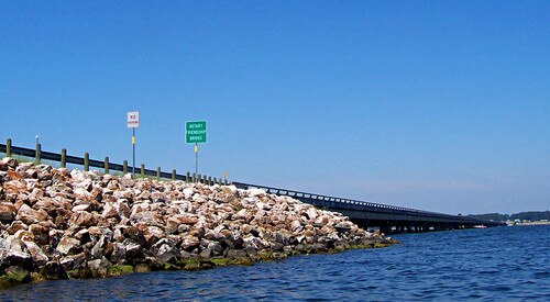
Farm to Market Road 1097 (FM 1097) is located in Walker and Montgomery counties. FM 1097 originally began at FM 149 in Montgomery, and ends nearly 30 miles (48 km) away at SH 150.[142] Most of the road has only two lanes each direction. The speed limit ranges from 60 mph (97 km/h) to 35 mph (56 km/h). There are very few traffic lights on the highway.
FM 1097 was first designated on December 16, 1948. The highway traveled from an intersection with FM 149 north of Montgomery along its present route to an intersection with U.S. Route 75 in Willis. On July 22 of the next year, the designation was extended 8.9 miles (14.3 km) to the Walker County border. The road was extended 1.2 miles (1.9 km) eastward, to the highway's present eastern terminus, on November 20, 1951. On May 2, 1962, the highway was extended 6.9 miles (11.1 km) northwestward to its present northern terminus.[142]
- Junction list
FM 1098
 Farm to Market Road 1098 | |
|---|---|
| Location | Waller County |
| Length | 4.389 mi[144] (7.063 km) |
| Existed | December 16, 1948[144]–present |
Farm to Market Road 1098 (FM 1098) is located in Waller County. It runs from FM 1488 northeast of Hempstead south to US 290 in Prairie View.
FM 1098 was designated on December 16, 1948, from Spur 96 (former SH 244) at Prairie View College north 9.7 miles (15.6 km) to a road intersection. On June 8, 1949, the route was shortened 1.7 miles (2.7 km) to end at a county road intersection at Field's Store School. On July 9, 1951, the road was extended to US 290 southeast of Hempstead, replacing a portion of Spur 96. On November 20, 1951, the road was extended 6.3 miles (10.1 km) north to the Grimes County line. On January 16, 1953, a 12.3-mile (19.8 km) section of FM 1098 was transferred to FM 362 and FM 1488, while a loop connection of FM 1098 was added around Prairie View College, replacing Loop 96. On September 29, 1976, the road was rerouted around the west side of Prairie View A&M College over the loop connection and the section through campus was removed from the highway system.
FM 1099
 Farm to Market Road 1099 | |
|---|---|
| Location | Atascosa County |
| Length | 7.67 mi[145] (12.34 km) |
| Existed | 1948[145]–present |
Farm to Market Road 1099 (FM 1099) is located in Atascosa County. Its western terminus at US 281 Alt. near Campbellton. The route runs to the east, crossing I-37/US 281 at exit 88, before turning to the southeast and ending at FM 99 near Peggy.[145][146]
FM 1099 was designated on December 16, 1948, from what was then US 281 eastward 5.7 miles (9.2 km) toward Fashing. The designation was extended 2 miles (3.2 km) to FM 99 on September 19, 1951.[145]
Notes
- ^ The certified length given is shorter than the actual mileage, as the TxDOT description of FM 1001 considers it to be discontinuous at rather than concurrent with the I-30 frontage road.
- ^ The certified length given is shorter than the actual mileage, as the TxDOT description of FM 1003 considers it to be discontinuous at rather than concurrent with FM 1293.
- ^ The certified length given is shorter than the actual mileage, as the TxDOT description of FM 1004 considers it to be discontinuous at rather than concurrent with US 96.
- ^ The certified length given is shorter than the actual mileage, as the TxDOT description of FM 1017 considers it to be discontinuous at rather than concurrent with FM 755.
- ^ RM 1022 was originally designated as FM 1022 from 1948 to 1959.
- ^ The certified length given is shorter than the actual mileage, as the TxDOT description of FM 1023 considers it to be discontinuous at rather than concurrent with US 90.
- ^ RM 1024 was originally designated as FM 1024 from 1948 to 1959.
- ^ RM 1050 was originally designated as FM 1050 from 1948 to 1959.
- ^ RM 1061 was originally designated as FM 1061 from 1948 to 1955.
References
- ^ a b c d Transportation Planning and Programming Division (n.d.). "Farm to Market Road No. 1000". Highway Designation Files. Texas Department of Transportation. Retrieved January 1, 2018.
- ^ Transportation Planning and Programming Division (2018). Texas County Mapbook (PDF) (Map) (2018 ed.). 1:72,224. Texas Department of Transportation. p. 590. Retrieved November 27, 2022.
- ^ a b Transportation Planning and Programming Division (2018). Texas County Mapbook (PDF) (Map) (2018 ed.). 1:72,224. Texas Department of Transportation. p. 548. Retrieved November 27, 2022.
- ^ "Texas Highway Commission" (PDF). Texas Department of Transportation. Retrieved May 26, 2013.
- ^ a b Transportation Planning and Programming Division (n.d.). "Farm to Market Road No. 1001". Highway Designation Files. Texas Department of Transportation. Retrieved January 1, 2018.
- ^ a b Transportation Planning and Programming Division (n.d.). "Farm to Market Road No. 1002". Highway Designation Files. Texas Department of Transportation. Retrieved January 1, 2018.
- ^ "Overview Map of FM 1002" (Map). Google Maps. Retrieved January 15, 2018.
- ^ a b Transportation Planning and Programming Division (n.d.). "Farm to Market Road No. 1003". Highway Designation Files. Texas Department of Transportation. Retrieved January 1, 2018.
- ^ "Overview Map of FM 1003" (Map). Google Maps. Retrieved January 15, 2018.
- ^ a b Transportation Planning and Programming Division (n.d.). "Farm to Market Road No. 1004". Highway Designation Files. Texas Department of Transportation. Retrieved January 1, 2018.
- ^ Transportation Planning and Programming Division (n.d.). "Farm to Market Road No. 1407". Highway Designation Files. Texas Department of Transportation. Retrieved January 15, 2018.
- ^ "Overview Map of FM 1004" (Map). Google Maps. Retrieved January 15, 2018.
- ^ a b c Transportation Planning and Programming Division (n.d.). "Farm to Market Road No. 1005". Highway Designation Files. Texas Department of Transportation. Retrieved January 1, 2018.
- ^ a b c Transportation Planning and Programming Division (n.d.). "Farm to Market Road No. 1006". Highway Designation Files. Texas Department of Transportation. Retrieved January 1, 2018.
- ^ Transportation Planning and Programming Division (n.d.). "State Highway Loop No. 171". Highway Designation Files. Texas Department of Transportation. Retrieved January 15, 2018.
- ^ "Overview Map of FM 1006" (Map). Google Maps. Retrieved January 16, 2018.
- ^ a b Transportation Planning and Programming Division (n.d.). "Farm to Market Road No. 1007". Highway Designation Files. Texas Department of Transportation. Retrieved January 1, 2018.
- ^ a b Transportation Planning and Programming Division (n.d.). "Farm to Market Road No. 1008". Highway Designation Files. Texas Department of Transportation. Retrieved January 1, 2018.
- ^ a b Transportation Planning and Programming Division (n.d.). "Farm to Market Road No. 1009". Highway Designation Files. Texas Department of Transportation. Retrieved January 1, 2018.
- ^ a b Transportation Planning and Programming Division (n.d.). "Farm to Market Road No. 1010". Highway Designation Files. Texas Department of Transportation. Retrieved January 1, 2018.
- ^ a b Transportation Planning and Programming Division (n.d.). "Farm to Market Road No. 1011". Highway Designation Files. Texas Department of Transportation. Retrieved January 1, 2018.
- ^ a b Transportation Planning and Programming Division (n.d.). "Farm to Market Road No. 1012". Highway Designation Files. Texas Department of Transportation. Retrieved January 1, 2018.
- ^ a b Transportation Planning and Programming Division (n.d.). "Farm to Market Road No. 1013". Highway Designation Files. Texas Department of Transportation. Retrieved January 1, 2018.
- ^ Transportation Planning and Programming Division (n.d.). "Farm to Market Road No. 2304". Highway Designation Files. Texas Department of Transportation. Retrieved January 15, 2018.
- ^ "Overview Map of FM 1013" (Map). Google Maps. Retrieved January 15, 2018.
- ^ a b Transportation Planning and Programming Division (n.d.). "Farm to Market Road No. 1014". Highway Designation Files. Texas Department of Transportation. Retrieved January 1, 2018.
- ^ a b Transportation Planning and Programming Division (n.d.). "Farm to Market Road No. 1015". Highway Designation Files. Texas Department of Transportation. Retrieved January 1, 2018.
- ^ a b Transportation Planning and Programming Division (n.d.). "Farm to Market Road No. 1016". Highway Designation Files. Texas Department of Transportation. Retrieved January 1, 2018.
- ^ Transportation Planning and Programming Division (n.d.). "Farm to Market Road No. 1926". Highway Designation Files. Texas Department of Transportation. Retrieved January 15, 2018.
- ^ Transportation Planning and Programming Division (n.d.). "State Highway No. 107". Highway Designation Files. Texas Department of Transportation. Retrieved January 15, 2018.
- ^ Transportation Planning and Programming Division (n.d.). "Urban Road No. 1016". Highway Designation Files. Texas Department of Transportation. Retrieved December 16, 2022.
- ^ a b c "Minute Order 115371" (PDF). Texas Transportation Commission. November 15, 2018. Retrieved December 16, 2022.
- ^ "Overview Map of FM 1016" (Map). Google Maps. Retrieved January 15, 2018.
- ^ a b Transportation Planning and Programming Division (n.d.). "Farm to Market Road No. 1017". Highway Designation Files. Texas Department of Transportation. Retrieved January 1, 2018.
- ^ "Overview Map of FM 1017" (Map). Google Maps. Retrieved January 2, 2018.
- ^ a b Transportation Planning and Programming Division (n.d.). "Farm to Market Road No. 1018". Highway Designation Files. Texas Department of Transportation. Retrieved January 1, 2018.
- ^ a b Transportation Planning and Programming Division (n.d.). "Farm to Market Road No. 1019". Highway Designation Files. Texas Department of Transportation. Retrieved January 1, 2018.
- ^ a b Transportation Planning and Programming Division (n.d.). "Farm to Market Road No. 1020". Highway Designation Files. Texas Department of Transportation. Retrieved January 1, 2018.
- ^ a b Transportation Planning and Programming Division (n.d.). "Farm to Market Road No. 1021". Highway Designation Files. Texas Department of Transportation. Retrieved January 1, 2018.
- ^ "Overview Map of FM 1021" (Map). Google Maps. Retrieved June 21, 2023.
- ^ a b Transportation Planning and Programming Division (n.d.). "Ranch to Market Road No. 1022". Highway Designation Files. Texas Department of Transportation. Retrieved January 2, 2018.
- ^ a b Transportation Planning and Programming Division (n.d.). "Farm to Market Road No. 1023". Highway Designation Files. Texas Department of Transportation. Retrieved January 2, 2018.
- ^ Transportation Planning and Programming Division (n.d.). "Ranch to Market Road No. 187". Highway Designation Files. Texas Department of Transportation. Retrieved January 15, 2018.
- ^ Transportation Planning and Programming Division (n.d.). "Farm to Market Road No. 3447". Highway Designation Files. Texas Department of Transportation. Retrieved January 15, 2018.
- ^ Transportation Planning and Programming Division (n.d.). "Farm to Market Road No. 1574". Highway Designation Files. Texas Department of Transportation. Retrieved January 15, 2018.
- ^ "Overview Map of FM 1023" (Map). Google Maps. Retrieved January 15, 2018.
- ^ a b Transportation Planning and Programming Division (n.d.). "Ranch to Market Road No. 1024". Highway Designation Files. Texas Department of Transportation. Retrieved January 2, 2018.
- ^ a b Transportation Planning and Programming Division (n.d.). "Farm to Market Road No. 1025". Highway Designation Files. Texas Department of Transportation. Retrieved January 2, 2018.
- ^ a b Transportation Planning and Programming Division (n.d.). "Farm to Market Road No. 1026". Highway Designation Files. Texas Department of Transportation. Retrieved January 2, 2018.
- ^ a b Transportation Planning and Programming Division (n.d.). "Farm to Market Road No. 1027". Highway Designation Files. Texas Department of Transportation. Retrieved January 2, 2018.
- ^ a b Transportation Planning and Programming Division (n.d.). "Farm to Market Road No. 1028". Highway Designation Files. Texas Department of Transportation. Retrieved January 2, 2018.
- ^ a b Transportation Planning and Programming Division (n.d.). "Farm to Market Road No. 1029". Highway Designation Files. Texas Department of Transportation. Retrieved January 2, 2018.
- ^ a b Transportation Planning and Programming Division (n.d.). "Farm to Market Road No. 1030". Highway Designation Files. Texas Department of Transportation. Retrieved January 2, 2018.
- ^ a b Transportation Planning and Programming Division (n.d.). "Farm to Market Road No. 1013". Highway Designation Files. Texas Department of Transportation. Retrieved January 2, 2018.
- ^ a b Transportation Planning and Programming Division (n.d.). "Farm to Market Road No. 1032". Highway Designation Files. Texas Department of Transportation. Retrieved January 2, 2018.
- ^ Transportation Planning and Programming Division (2018). Texas County Mapbook (PDF) (Map) (2018 ed.). 1:72,224. Texas Department of Transportation. p. 740. Retrieved December 5, 2022.
- ^ a b Transportation Planning and Programming Division (n.d.). "Farm to Market Road No. 1033". Highway Designation Files. Texas Department of Transportation. Retrieved January 2, 2018.
- ^ a b Transportation Planning and Programming Division (n.d.). "Farm to Market Road No. 1034". Highway Designation Files. Texas Department of Transportation. Retrieved January 2, 2018.
- ^ a b Transportation Planning and Programming Division (n.d.). "Farm to Market Road No. 1035". Highway Designation Files. Texas Department of Transportation. Retrieved January 2, 2018.
- ^ a b Transportation Planning and Programming Division (n.d.). "Farm to Market Road No. 1036". Highway Designation Files. Texas Department of Transportation. Retrieved January 2, 2018.
- ^ a b c d Transportation Planning and Programming Division (n.d.). "Farm to Market Road No. 1037". Highway Designation Files. Texas Department of Transportation. Retrieved January 2, 2018.
- ^ a b Transportation Planning and Programming Division (n.d.). "Farm to Market Road No. 1038". Highway Designation Files. Texas Department of Transportation. Retrieved January 2, 2018.
- ^ a b Transportation Planning and Programming Division (n.d.). "Farm to Market Road No. 1039". Highway Designation Files. Texas Department of Transportation. Retrieved January 2, 2018.
- ^ a b Transportation Planning and Programming Division (n.d.). "Farm to Market Road No. 1040". Highway Designation Files. Texas Department of Transportation. Retrieved January 2, 2018.
- ^ a b Transportation Planning and Programming Division (n.d.). "Farm to Market Road No. 1041". Highway Designation Files. Texas Department of Transportation. Retrieved January 2, 2018.
- ^ a b Transportation Planning and Programming Division (n.d.). "Farm to Market Road No. 1042". Highway Designation Files. Texas Department of Transportation. Retrieved January 2, 2018.
- ^ a b Transportation Planning and Programming Division (n.d.). "Farm to Market Road No. 1043". Highway Designation Files. Texas Department of Transportation. Retrieved January 2, 2018.
- ^ a b c d e f Transportation Planning and Programming Division (n.d.). "Farm to Market Road No. 1044". Highway Designation Files. Texas Department of Transportation. Retrieved January 2, 2018.
- ^ Transportation Planning and Programming Division (2018). Texas County Mapbook (PDF) (Map) (2018 ed.). 1:72,224. Texas Department of Transportation. p. 1787. Retrieved July 16, 2021.
- ^ Transportation Planning and Programming Division (2018). Texas County Mapbook (PDF) (Map) (2018 ed.). 1:72,224. Texas Department of Transportation. p. 1831. Retrieved July 16, 2021.
- ^ a b Transportation Planning and Programming Division (n.d.). "Farm to Market Road No. 1045". Highway Designation Files. Texas Department of Transportation. Retrieved January 2, 2018.
- ^ a b Transportation Planning and Programming Division (n.d.). "Farm to Market Road No. 1046". Highway Designation Files. Texas Department of Transportation. Retrieved January 2, 2018.
- ^ a b c Transportation Planning and Programming Division (n.d.). "Farm to Market Road No. 1047". Highway Designation Files. Texas Department of Transportation. Retrieved January 2, 2018.
- ^ Transportation Planning and Programming Division (2018). Texas County Mapbook (PDF) (Map) (2018 ed.). 1:72,224. Texas Department of Transportation. p. 1212. Retrieved July 4, 2023.
- ^ Transportation Planning and Programming Division (2018). Texas County Mapbook (PDF) (Map) (2018 ed.). 1:72,224. Texas Department of Transportation. p. 1156. Retrieved July 4, 2023.
- ^ Transportation Planning and Programming Division (2018). Texas County Mapbook (PDF) (Map) (2018 ed.). 1:72,224. Texas Department of Transportation. p. 1099. Retrieved July 4, 2023.
- ^ Transportation Planning and Programming Division (n.d.). "Farm to Market Road No. 2707". Highway Designation Files. Texas Department of Transportation. Retrieved January 14, 2018.
- ^ "Overview Map of FM 1047" (Map). Google Maps. Retrieved January 14, 2018.
- ^ a b Transportation Planning and Programming Division (n.d.). "Farm to Market Road No. 1048". Highway Designation Files. Texas Department of Transportation. Retrieved January 2, 2018.
- ^ a b Transportation Planning and Programming Division (n.d.). "Farm to Market Road No. 1049". Highway Designation Files. Texas Department of Transportation. Retrieved January 2, 2018.
- ^ a b Transportation Planning and Programming Division (n.d.). "Ranch to Market Road No. 1050". Highway Designation Files. Texas Department of Transportation. Retrieved January 2, 2018.
- ^ a b c d Transportation Planning and Programming Division (n.d.). "Farm to Market Road No. 1051". Highway Designation Files. Texas Department of Transportation. Retrieved January 2, 2018.
- ^ Transportation Planning and Programming Division (2018). Texas County Mapbook (PDF) (Map) (2018 ed.). 1:72,224. Texas Department of Transportation. p. 1863. Retrieved June 6, 2023.
- ^ Transportation Planning and Programming Division (2018). Texas County Mapbook (PDF) (Map) (2018 ed.). 1:72,224. Texas Department of Transportation. p. 1824. Retrieved June 6, 2023.
- ^ Ochoa, Ruben E.: Reagan Wells, TX from the Handbook of Texas Online (June 28, 2021). Retrieved June 6, 2023.
- ^ a b Transportation Planning and Programming Division (n.d.). "Farm to Market Road No. 1052". Highway Designation Files. Texas Department of Transportation. Retrieved January 2, 2018.
- ^ a b Transportation Planning and Programming Division (n.d.). "Farm to Market Road No. 1053". Highway Designation Files. Texas Department of Transportation. Retrieved January 2, 2018.
- ^ a b Transportation Planning and Programming Division (n.d.). "Farm to Market Road No. 1054". Highway Designation Files. Texas Department of Transportation. Retrieved January 2, 2018.
- ^ a b Transportation Planning and Programming Division (n.d.). "Farm to Market Road No. 1055". Highway Designation Files. Texas Department of Transportation. Retrieved January 2, 2018.
- ^ a b Transportation Planning and Programming Division (n.d.). "Farm to Market Road No. 1056". Highway Designation Files. Texas Department of Transportation. Retrieved January 2, 2018.
- ^ a b Transportation Planning and Programming Division (n.d.). "Farm to Market Road No. 1057". Highway Designation Files. Texas Department of Transportation. Retrieved January 2, 2018.
- ^ a b c d Transportation Planning and Programming Division (n.d.). "Farm to Market Road No. 1058". Highway Designation Files. Texas Department of Transportation. Retrieved January 2, 2018.
- ^ Transportation Planning and Programming Division (2018). Texas County Mapbook (PDF) (Map) (2018 ed.). 1:72,224. Texas Department of Transportation. p. 184. Retrieved June 1, 2023.
- ^ Transportation Planning and Programming Division (2018). Texas County Mapbook (PDF) (Map) (2018 ed.). 1:72,224. Texas Department of Transportation. p. 181. Retrieved June 1, 2023.
- ^ Transportation Planning and Programming Division (n.d.). "State Highway No. 51". Highway Designation Files. Texas Department of Transportation. Retrieved June 1, 2023.
- ^ Anderson, H. Allen: Deaf Smith County from the Handbook of Texas Online (June 22, 2019). Retrieved June 1, 2023.
- ^ a b Transportation Planning and Programming Division (n.d.). "Farm to Market Road No. 1059". Highway Designation Files. Texas Department of Transportation. Retrieved January 2, 2018.
- ^ a b Transportation Planning and Programming Division (n.d.). "Farm to Market Road No. 1060". Highway Designation Files. Texas Department of Transportation. Retrieved January 11, 2018.
- ^ a b Transportation Planning and Programming Division (n.d.). "Ranch to Market Road No. 1061". Highway Designation Files. Texas Department of Transportation. Retrieved January 11, 2018.
- ^ Transportation Planning and Programming Division (n.d.). "State Highway No. 51". Highway Designation Files. Texas Department of Transportation. Retrieved January 11, 2018.
- ^ Transportation Planning and Programming Division (n.d.). "Urban Road No. 1061". Highway Designation Files. Texas Department of Transportation. Retrieved January 11, 2018.
- ^ "Overview Map of RM 1061" (Map). Google Maps. Retrieved January 11, 2018.
- ^ a b Transportation Planning and Programming Division (n.d.). "Farm to Market Road No. 1062". Highway Designation Files. Texas Department of Transportation. Retrieved January 11, 2018.
- ^ a b Transportation Planning and Programming Division (n.d.). "Farm to Market Road No. 1063". Highway Designation Files. Texas Department of Transportation. Retrieved January 11, 2018.
- ^ a b Transportation Planning and Programming Division (n.d.). "Farm to Market Road No. 1064". Highway Designation Files. Texas Department of Transportation. Retrieved January 11, 2018.
- ^ a b Transportation Planning and Programming Division (n.d.). "Farm to Market Road No. 1065". Highway Designation Files. Texas Department of Transportation. Retrieved January 11, 2018.
- ^ a b Transportation Planning and Programming Division (n.d.). "Farm to Market Road No. 1066". Highway Designation Files. Texas Department of Transportation. Retrieved January 11, 2018.
- ^ a b Transportation Planning and Programming Division (n.d.). "Farm to Market Road No. 1067". Highway Designation Files. Texas Department of Transportation. Retrieved January 11, 2018.
- ^ a b Transportation Planning and Programming Division (n.d.). "Farm to Market Road No. 1068". Highway Designation Files. Texas Department of Transportation. Retrieved January 11, 2018.
- ^ a b Transportation Planning and Programming Division (n.d.). "Farm to Market Road No. 1069". Highway Designation Files. Texas Department of Transportation. Retrieved January 11, 2018.
- ^ a b Transportation Planning and Programming Division (n.d.). "Farm to Market Road No. 1070". Highway Designation Files. Texas Department of Transportation. Retrieved January 13, 2018.
- ^ a b Transportation Planning and Programming Division (n.d.). "Farm to Market Road No. 1071". Highway Designation Files. Texas Department of Transportation. Retrieved January 13, 2018.
- ^ a b Transportation Planning and Programming Division (n.d.). "Farm to Market Road No. 1072". Highway Designation Files. Texas Department of Transportation. Retrieved January 13, 2018.
- ^ a b Transportation Planning and Programming Division (n.d.). "Farm to Market Road No. 1073". Highway Designation Files. Texas Department of Transportation. Retrieved January 13, 2018.
- ^ a b Transportation Planning and Programming Division (n.d.). "Farm to Market Road No. 1074". Highway Designation Files. Texas Department of Transportation. Retrieved January 13, 2018.
- ^ a b Transportation Planning and Programming Division (n.d.). "Farm to Market Road No. 1075". Highway Designation Files. Texas Department of Transportation. Retrieved January 13, 2018.
- ^ a b Transportation Planning and Programming Division (n.d.). "Farm to Market Road No. 1076". Highway Designation Files. Texas Department of Transportation. Retrieved January 13, 2018.
- ^ a b Transportation Planning and Programming Division (n.d.). "Ranch to Market Road No. 1077". Highway Designation Files. Texas Department of Transportation. Retrieved January 13, 2018.
- ^ a b Transportation Planning and Programming Division (n.d.). "Farm to Market Road No. 1078". Highway Designation Files. Texas Department of Transportation. Retrieved January 13, 2018.
- ^ a b Transportation Planning and Programming Division (n.d.). "Farm to Market Road No. 1079". Highway Designation Files. Texas Department of Transportation. Retrieved January 13, 2018.
- ^ a b Transportation Planning and Programming Division (n.d.). "Farm to Market Road No. 1080". Highway Designation Files. Texas Department of Transportation. Retrieved January 13, 2018.
- ^ a b Transportation Planning and Programming Division (n.d.). "Farm to Market Road No. 1081". Highway Designation Files. Texas Department of Transportation. Retrieved January 13, 2018.
- ^ a b Transportation Planning and Programming Division (n.d.). "Farm to Market Road No. 1082". Highway Designation Files. Texas Department of Transportation. Retrieved January 13, 2018.
- ^ a b Transportation Planning and Programming Division (n.d.). "Farm to Market Road No. 1083". Highway Designation Files. Texas Department of Transportation. Retrieved January 13, 2018.
- ^ a b Transportation Planning and Programming Division (n.d.). "Farm to Market Road No. 1084". Highway Designation Files. Texas Department of Transportation. Retrieved January 13, 2018.
- ^ a b Transportation Planning and Programming Division (n.d.). "Farm to Market Road No. 1085". Highway Designation Files. Texas Department of Transportation. Retrieved January 13, 2018.
- ^ a b Transportation Planning and Programming Division (n.d.). "Farm to Market Road No. 1086". Highway Designation Files. Texas Department of Transportation. Retrieved January 13, 2018.
- ^ a b Transportation Planning and Programming Division (n.d.). "Farm to Market Road No. 1087". Highway Designation Files. Texas Department of Transportation. Retrieved January 13, 2018.
- ^ a b c d Transportation Planning and Programming Division (n.d.). "Farm to Market Road No. 1088". Highway Designation Files. Texas Department of Transportation. Retrieved January 13, 2018.
- ^ Transportation Planning and Programming Division (2018). Texas County Mapbook (PDF) (Map) (2018 ed.). 1:72,224. Texas Department of Transportation. p. 1179. Retrieved August 19, 2020.
- ^ a b Transportation Planning and Programming Division (n.d.). "Farm to Market Road No. 1089". Highway Designation Files. Texas Department of Transportation. Retrieved January 13, 2018.
- ^ a b Transportation Planning and Programming Division (n.d.). "Farm to Market Road No. 1090". Highway Designation Files. Texas Department of Transportation. Retrieved January 13, 2018.
- ^ a b Transportation Planning and Programming Division (n.d.). "Farm to Market Road No. 1091". Highway Designation Files. Texas Department of Transportation. Retrieved January 13, 2018.
- ^ a b Transportation Planning and Programming Division (n.d.). "Farm to Market Road No. 1092". Highway Designation Files. Texas Department of Transportation. Retrieved January 13, 2018.
- ^ a b Transportation Planning and Programming Division (n.d.). "Farm to Market Road No. 1093". Highway Designation Files. Texas Department of Transportation. Retrieved January 13, 2018.
- ^ Transportation Planning and Programming Division (n.d.). "Urban Road No. 1093". Highway Designation Files. Texas Department of Transportation. Retrieved December 16, 2022.
- ^ "List of Farm to Market Roads in Texas (1000–1099)" (Map). Google Maps. Retrieved August 5, 2019.
- ^ a b Transportation Planning and Programming Division (n.d.). "Farm to Market Road No. 1094". Highway Designation Files. Texas Department of Transportation. Retrieved January 13, 2018.
- ^ a b Transportation Planning and Programming Division (n.d.). "Farm to Market Road No. 1095". Highway Designation Files. Texas Department of Transportation. Retrieved January 15, 2018.
- ^ a b c Transportation Planning and Programming Division (n.d.). "Farm to Market Road No. 1096". Highway Designation Files. Texas Department of Transportation. Retrieved January 13, 2018.
- ^ "List of Farm to Market Roads in Texas (1000–1099)" (Map). Google Maps. Retrieved January 5, 2013.
- ^ a b c d Transportation Planning and Programming Division (n.d.). "Farm to Market Road No. 1097". Highway Designation Files. Texas Department of Transportation. Retrieved January 13, 2018.
- ^ 州全体の計画マップ(地図)。交通計画およびプログラミング部門による地図作成。テキサス州運輸省。 2013年1月22日閲覧。
- ^ ab 交通計画・プログラミング課 (nd). 「Farm to Market Road No. 1098」.高速道路指定ファイル.テキサス州運輸省. 2018年1月13日閲覧。
- ^ abcd Transportation Planning and Programming Division (nd). 「Farm to Market Road No. 1099」.高速道路指定ファイル.テキサス州運輸省. 2018年1月13日閲覧。
- ^ 交通計画プログラミング課 (2018)。テキサス郡地図帳(PDF) (地図) (2018 版)。1:72,224。テキサス州運輸省。p. 2023 。2023 年6 月 27 日閲覧。