
Loading article…

1880 年の後期ビクトリア朝時代のロサンゼルスのダウンタウンは、ロサンゼルス プラザ地区の南端を中心としており、その後 20 年かけて、メイン ストリート、スプリング ストリート、ブロードウェイに沿って南西方向にサード ストリートまで広がっていきました。19 世紀の建物のほとんどはもはや存在せず、プラザ地区またはセカンド ストリートの南にのみ残っています。残りは、市庁舎、多数の裁判所、その他の市、郡、州、連邦政府の建物、タイムズ ミラー スクエアがあるシビック センター地区を作るために取り壊されました。[ 1 ] [ 2 ]この記事では、プラザ、サード ストリート、ロサンゼルス ストリート、ブロードウェイの間のそのエリアを、1880 年から取り壊しの期間 (1920 年代から 1950 年代) まで扱います。
当時(1880~1900年代)、この地域はビジネスセンター、ビジネスセクション、またはビジネス地区と呼ばれていました。1910年までには、その地域はビジネス地区の「ノースエンド」と呼ばれるようになり、そのビジネス地区は当時、ブロードウェイ、スプリング、メイン沿いの3番街から9番街にかけての、現在ヒストリック・コアと呼ばれる地域まで南に拡大していました。[ 3 ]

1890年代半ばまでに、ファースト通りとスプリング通りは商業地区の中心地となり、ブラッドベリービルは1893年にサード通りとブロードウェイの角にオープンし、現在も残っている。[ 4 ] 1910年までに、フォース通りの北側は商業地区の「ノースエンド」と見なされ、商業の中心が現在ヒストリック・コアとして知られるサード通りからナインス通りに移ったため、その衰退がすでに懸念されていた。 [ 5 ]
この地図は1910年当時の街路網を示しており、1920年代から1950年代にかけて行われた3つの重要な道路配置変更を青色で示している。


テンプルストリートケーブル鉄道のケーブルカーは1886年からテンプルストリート沿いを走っており、1902年にパシフィック・エレクトリックの路面電車に置き換えられた。 [ 6 ] [ 7 ]

この場所は当時パウンドケーキヒルとして知られていました。ここに建つ建物は東側がニューハイストリート、西側がブロードウェイに面していました。それらは以下の通りです。[ 11 ]
現在サイトに掲載されているのは以下のとおりです。
南側に隣接し、街区の中央付近には、グランドパークの一部がある。


南西の角は、ビクトリア時代には特に目立った小売店やオフィスビルが建っていた場所でしたが、1958年からは州庁舎(1958~60年、建築家アンソン・C・ボイド、2006年取り壊し)が建っていました。この建物はジュニペロ・セラ州庁舎と名付けられ、この名称は1998年にこの建物の跡地に建てられた旧ブロードウェイ百貨店ビル(4番街とブロードウェイの角)に引き継がれました。[ 17 ]現在は、2016年に建設された新しい米国裁判所が建っており、ブロードウェイ、ヒル、ファースト、セカンドの間のブロック全体を占めています。[ 18 ]
南西角のすぐ南には、127 S. Broadway にあるメイソン劇場があった。1903 年にメイソン・オペラハウスとして開館し、座席数は 1,600 席だった。シカゴの建築事務所マーシャル & ウィルソンのベンジャミン・マーシャルがジョン・パーキンソンと共同で設計した。マーシャルはシカゴのイロコイ劇場の設計者として知られている。1924 年にマイヤー & ホラーによって改築された。その後、メイソン劇場としてスペイン語映画を上映した。1955 年に取り壊された。[ 19 ]
145 S. Broadway、[ 20 ] CH Frost ビルの跡地。後にHaig M. Prince ビルとして知られる。1898 年建設、建築家はJohn Parkinson、[ 21 ]現在は、2016 年に建設された新しい米国裁判所 の場所であり、ブロードウェイ、ヒル、ファースト、セカンドの間のブロック全体を占めている。[ 18 ]


ロサンゼルスのダウンタウンに点在するヘルマン・ビルディングのうちの1つ(フォース・ストリートとスプリング・ストリートにある現存するヘルマン・ビルディングとは別物)が、1897年から1959年までここに(138番地)ありました。[ 22 ]現在、この場所はタイムズ・ミラー・スクエア複合施設の一部である駐車場になっています。


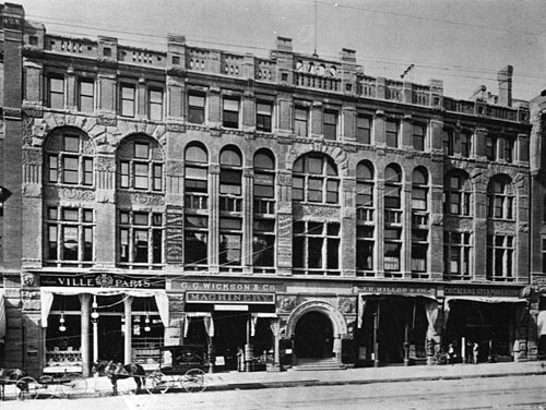
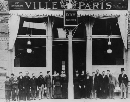

サウス・ブロードウェイ200番地の西側は、1893年から1917年にかけてロサンゼルスの小売業の歴史において重要な位置を占めていました。そこには、ヴィル・ド・パリ、 1905年から1917年まで営業していたコールター百貨店、1895年から1915年まで営業していたJWロビンソンの「ボストン・ドライグッズ」店など、初期の著名な百貨店がいくつかありました。これら3つの百貨店は、1915年から1917年にかけてセブンス・ストリートが高級ショッピング街になると、いずれもセブンス・ストリートに移転しました。
ブロードウェイの西側をさらに南に進むと、207~211番地があり、そこには以下の建物があった。
YMCAビルは、以下の建物を建設するために取り壊されました。
隣接するポトマックブロックとビックネルブロックは、当初は当時の著名な小売店が入居していましたが、1906年にコールター百貨店が加わり複合施設となり、1905年6月に157,000 平方 フィート(14,600 平方メートル)の新しい店舗としてオープンしました。[ 26 ] [ 27 ] [ 28 ]
ポトマック・ブロック(サウス・ブロードウェイ213~223番地)は、1905年から1917年まではBFコールター・ビルディングとして知られていました。元々は製材所と製粉所のオーナーであるJMグリフィスによって開発されました。1888年にブロック、カーレット、アイゼンによってロマネスク様式で設計され[ 29 ] 、1890年7月17日にオープンしました[ 30 ]。
テナントには以下が含まれます。
サウス・ブロードウェイに大手小売店がオープンしたのはこれが初めてで、1890年から1905年にかけて、高級ショッピング街の中心がファースト・ストリートとスプリング・ストリート周辺からサウス・ブロードウェイへと移り変わるきっかけとなった。1904年、コールターズはポトマック・ブロックを購入し、ビックネル・ブロックと統合して、1905年にオープンした新店舗を建設した。
コールターが引っ越した後:
その建物は1953年に取り壊され、現在も駐車場になっている。[ 31 ]
225〜229 S. Broadway にあるBicknell Block (または Bicknell Building) は、224〜228 S. Hill Street に裏口があり、1905 年から 1917 年までは Coulter's の一部でした。1917 年に Coulter's が移転した後、Western Shoe Co. (1922 年まで) が入居し、その後 Western Department Store (1922〜1928 年) として知られるようになりました。1950 年代末まで、建物の正面は上から下まで「西部最大の靴売り場」という文字で覆われていました。[ 32 ]


2番街とブロードウェイの南東角には、以下のものがあった。
中間ブロックは以下の通り:
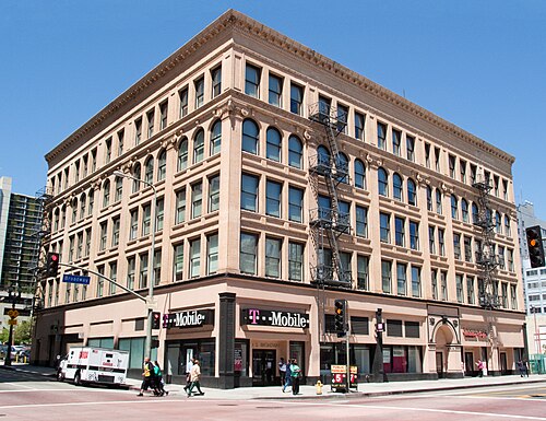
この角地には、プラザ地区以外では最も古い建物のひとつである、1895年建造のアーバイン・バーン・ビルディング(アーバイン・ブロック、またはバーン・ビルディングとも呼ばれる)があり、現在はパン・アメリカン・ロフトと呼ばれている。設計はサムナー・ハント。スペイン植民地復興様式とボザール様式を融合させた建築様式である。
この建物には、1899年1月2日に開店した有名な衣料品店I. Magninが入っていました。 [ 43 ] 1904年6月19日、I. Magninはロサンゼルス店が今後Myer Siegelとして知られるようになると発表しました。[ 36 ] 1911年2月16日にアーバイン・バーン・ビルディングで火災が発生し店舗が焼失した後、Myer Siegelはブロードウェイのさらに南に移転しました。
2007年に近代化されロフトに改装され、現在の名前が付けられました。ホールと階段は多くの映画やテレビコマーシャルに登場しています。[ 44 ]
サードストリートから南のオリンピック大通り(旧称テンスストリート)まで、そしてヒルストリートから東のロサンゼルスストリートまで(ブロードウェイを含む)は、ヒストリック・コア地区と呼ばれ、20世紀前半における市の主要な商業・娯楽地区である。


この角:[ 45 ]


スプリング通りの西側には、以下の建物が建っていました。スプリング通りは1920年代に付け替えられ、現在はこれらの建物の西側を通っています。そして、これらの建物がかつて建っていた場所は、現在では市庁舎が建つ街区全体の一部となっています。
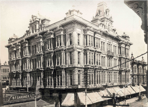

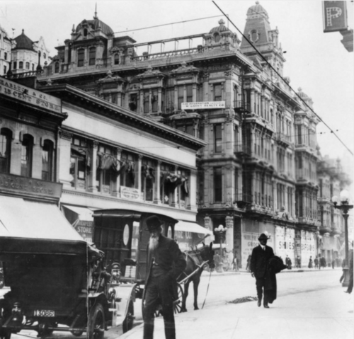

フランクリン通りとスプリング通りの北西の角には、ロチャ・アドベ、そしてフィリップス・ブロックという2つの建物が連続して建っていた。現在、その場所はスプリング通りの現在のルートの下に位置しており、スプリング通りは1920年代に直線化、つまり西側に付け替えられた。
1894年から1905年まで、フランクリン通りの南西の角には、ランドマークの時計を備えたハリス&フランクのロンドン衣料品店がありました。 [ 61 ] [ 62 ]ハリス&フランクはその後、この地域全体に男性服のジュニア百貨店のチェーンとなりました。


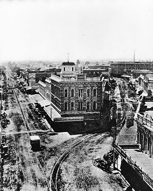
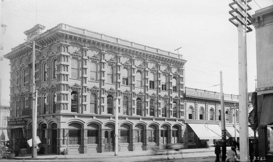


テンプル通りの南側でスプリング通りとメイン通りが交わる三角形の空間は、テンプルブロックの跡地でした。実際には、スプリング通り、メイン通り、テンプル通りに囲まれたブロックを占めていたさまざまな建物の集合体でした。最初の、または旧テンプルブロックは、1856年にフランシスコ(FPF)テンプルによって建てられ、アドベ造りの2階建てで、テンプル通りに面して北向きでした。これは、1871年に拡張された後のテンプルブロックに組み込まれ、その後取り壊されました。ジョージ・P・マクレーンは、1868年に町に到着したとき、テンプルブロックは町の商業と社会生活の中心地であることは疑いようがなかったと書いています。1880年代初頭まで、それは市内で最も堂々とした建物と見なされていました。そこには、スティーブン・M・ホワイト、ウィル・D・グールド、グラッセル、チャップマン、スミスなどの法律事務所が多数入居していました。[ 63 ]このブロックはロサンゼルスの小売業の歴史において重要な役割を果たしました。市内で有名になる高級小売店がいくつか最初に入居した場所だったからです。デズモンド(1870~1882年)[ 64 ]とジャコビー・ブラザーズ(1879~1891年)[ 65 ]また、オッド・フェローズ、ファッション・サルーン、テンプル・アンド・ワークマン銀行、スロッターベックの銃砲店、ウェルズ・ファーゴのオフィスもありました。北東の角には、アドルフ・ポルトガルの雑貨店(1874~1879年?)、ジャコビー・ブラザーズ(1879~1891年) 、コーン・ブラザーズ(1892~1897年)が順番に入居していました。[ 66 ] [ 67 ]
1925年から1927年にかけて、この街区と周辺地域は、現在のロサンゼルス市庁舎を建設するために取り壊された。
テンプルブロックの南側にはマーケットストリートがあり、スプリングストリートとメインストリートの間を走る小さな通りだった。


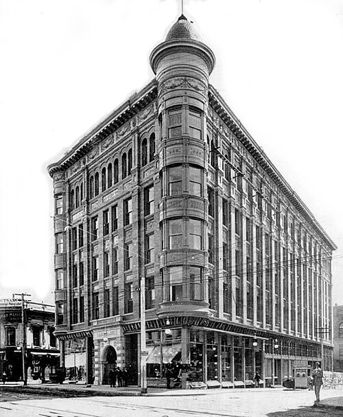
テンプルブロックのすぐ南、マーケット通りとコート通りの間の小さな区画には、スプリング通りとメイン通りの両方に面して、2つの建物が並んで建っていた。

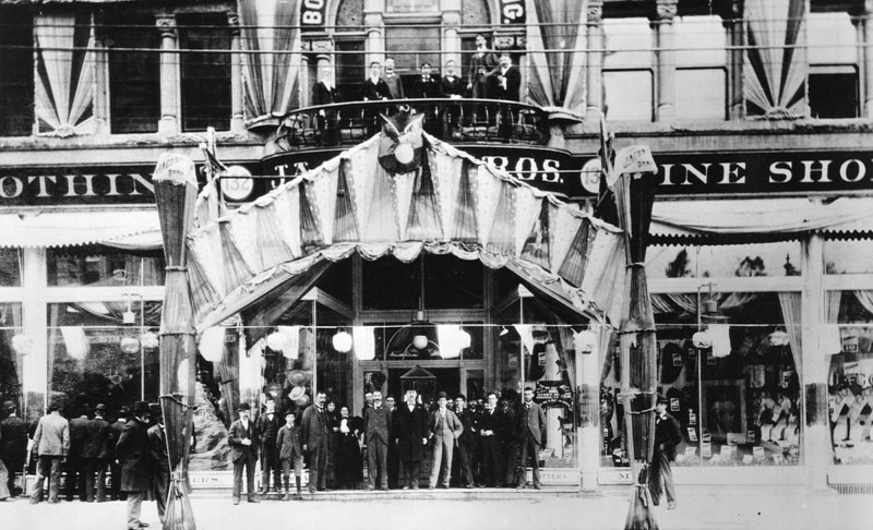

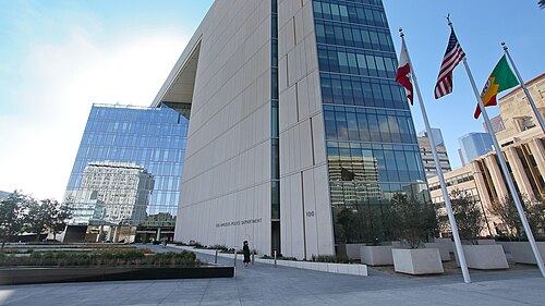
左上の画像は、1900年から1906年頃、ファースト通りとスプリング通りの交差点から南方向を撮影したものです。左側にはウィルソン・ブロックの尖塔が、右側にはナドー・ホテルが目立っています。手前には、左側にロサンゼルス・ナショナル・バンク、右側にラロンド・ブロックが見えます。ファースト通りからセカンド通りにかけてのスプリング通りは、今も賑やかなショッピング街ですが、ブロードウェイも高級ショッピング街として人気が出始めています。路面電車がモンテシト・ハイツのグリフィン通りに向かって走っており、これは後にロサンゼルス鉄道2号線となる路線です。現在では、この景色は左側のブロック全体を占める2009年建設のロサンゼルス市警察本部、右側の1935年建設のロサンゼルス・タイムズ・ビル、そしてその奥にある1948年建設のクロフォード・ミラー・アディション・ビルに相当します。
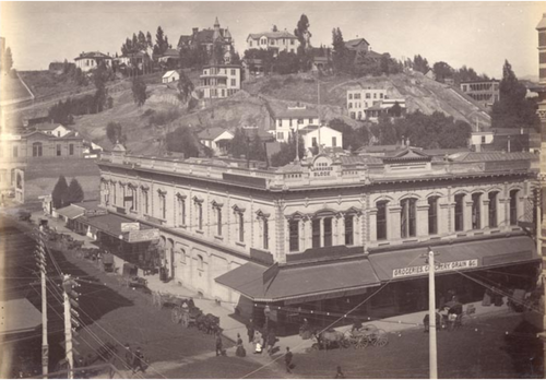
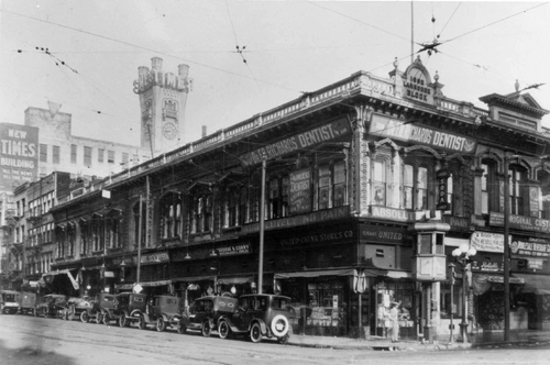


スプリング通りの東側、ファーストストリート沿いには、1883年に建てられたウィドニー・ブロック(ジョセフ・ウィドニーの名を冠した建物)が北側に沿って建っている。1880年代半ばには、このブロックに オルムステッド&ウェールズ書店の本店があった。


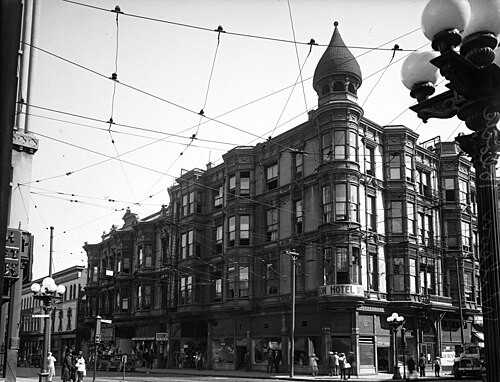

ここにはこれまでに4つの建物が建っていた。


その跡地には、1948年に建てられたクロフォード・アディション・ビルが建設された。このビルはタイムズ・ミラー・スクエア複合施設の一部だが、現在は空き家となっている。


西側では:
2つの劇場を合わせてペリー・ビルディングと呼んだ建物:
東側では:




Pico House was a luxury hotel built in 1870 by Pío Pico, a successful businessman who was the last Mexican Governor of Alta California. With indoor plumbing, gas-lit chandeliers, a grand double staircase, lace curtains, and a French restaurant, the Italianate three-story, 33-room hotel was the most elegant hotel in Southern California. It had a total of nearly eighty rooms. The Pico House is listed as a California Historical Landmark (No. 159).
Masonic Hall at 416 N. Main St., was built in 1858 as Lodge 42 of the Free and Accepted Masons. The building was a painted brick structure with a symbolic "Masonic eye" below the parapet. In 1868, the Masons moved to larger quarters further south. Afterward, the building was used for many purposes, including a pawn shop and boarding house. It is the oldest building in Los Angeles south of the Plaza.
The Merced Theater, completed in 1870, was built in an Italianate style and operated as a live theatre from 1871 to 1876. When the Woods Opera House opened nearby in 1876, the Merced ceased being the city's leading theatre.[116] Eventually, it gained an "unenviable reputation" because of "the disreputable dances staged there, and was finally closed by the authorities."[117]
This two-story building at 507–511 N. Main St. houses part of the LA Plaza de Cultura y Artes, which includes the Vickrey -Brunswig Building next door.[118] It is inscribed on its upper floor, and on 1890s maps it is marked, "Garnier Block" (not to be confused with the Garnier Block/Building on Los Angeles Street, one block away). Commissioned in 1883 by Philippe Garnier, once housed the "La Esperanza" bakery.[119]
This five-story brick building facing the Plaza at 501 N. Main St. houses LA Plaza de Cultura y Artes, which also occupies the Plaza House next door. It was built in 1888 and combines Italianate and Victorian architecture; the architect was Robert Brown Young.[120]
The Sentous Block or Sentous Building (19th c., demolished late 1950s) was located at 615-9 N Main St., with a back entrance on 616-620 North Spring St. (previously called Upper Main St., then San Fernando St.). Designed in 1886 by Burgess J. Reeve. Louis Sentous was a French pioneer in the early days of Los Angeles.[121] The San Fernando Theatre was located here. The site is now part of the El Pueblo parking lot.[122][123]

This block is part of the site of the current Spring Street Courthouse. Buildings previously located here include:
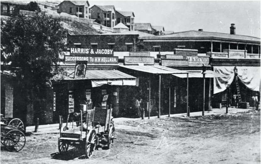


On this corner stood four buildings in succession, the first two of which had a key role in the history of retail in Southern California, as it was home to a number of upscale retailers who would later grow to be big names in the city, and some, regional chains.
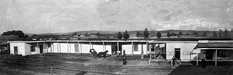
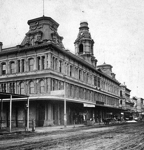


South of the Baker Block stood buildings that are now the site of the northwestern-most part of the Los Angeles Mall:
The Los Angeles Mall replaced these blocks; it is a small shopping center at the Los Angeles Civic Center, between Main and Los Angeles Streets on the north and south sides of Temple Street, connected by both a pedestrian bridge and a tunnel. It features Joseph Young's sculpture Triforium, with 1,500 blown-glass prisms synchronized to an electronic glass bell carillon. The mall opened in 1974 and includes a four-level parking garage with 2,400 spaces.


Currently, this site is the southernmost end of the Los Angeles Mall; Triforium is approximately on the site of Commercial Street.[142]

This block is, since 1928, the site of Los Angeles City Hall


On the corner of Third and Main:[152]

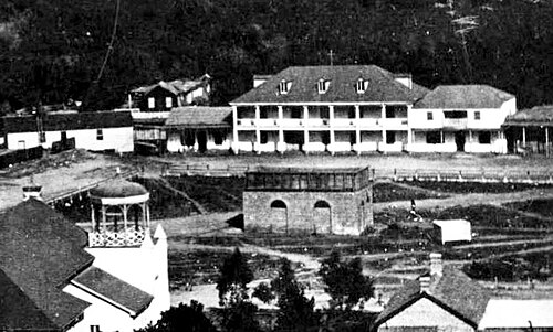



The Coronel Adobe was demolished in 1888 and 1896 Sanborn maps show that the Del Valle adobe had been removed, and Los Angeles Street had been extended[153] to form the eastern edge of the Plaza, thus passing in front of the Lugo Adobe. Calle de los Negros remained for a few more decades, behind a row of houses lining the east side of Los Angeles Street between Arcadia and Aliso streets. This was also the western edge of Old Chinatown from around the 1880s through 1930s. It reached eastward across Alameda St. to cover most of the area that is now Union Station. It proceeded one more block past the Plaza, with the buildings on the east side of Olvera Street forming its western edge, until terminating at Alameda Street.[154]
Since the early 1950s, Los Angeles Street has formed the eastern edge of the Plaza, but the buildings lining its eastern edge, including the Lugo Adobe, were removed.[155][156] The site is now Father Serra Park.

When it was extended past the Plaza in 1888,[153] Los Angeles Street terminated one short block north of the Plaza at Alameda Street. Now, Los Angeles Street turns east at the north side of the Plaza to terminate at Alameda Street at a right angle, directly across from the Union Station complex. What was the short block of Los Angeles Street north of the Plaza is now part of Placita Dolores, a small open plaza which surrounds a statue of Mexican charro entertainer Antonio Aguilar on horseback.[157]
Until the late 19th century, Los Angeles Street did not form the east side of the Plaza; it ran south only from Broad Place at the intersection of Arcadia Street. Here, the Coronel Adobe blocked the path north one block to the Plaza, but just slightly to the right (east) of the path of Los Angeles Street was Calle de los Negros (Spanish-language name; marked on post-1847 maps as Negro Alley or Nigger Alley), a narrow, one-block north–south street likely named after darker-skinned Mexican afromestizo and/or mulatto residents during the Spanish colonial era.[158][159]. At the north end of Calle de los Negros stood the Del Valle adobe (also known as the Matthias or Matteo Sabichi house),[160][161] at the southern edge of which one could turn left and enter the plaza at its southeast corner. Calle de los Negros was famous for its saloons and violence in the early days of the town, and by the 1880s was considered part of Chinatown, lined with Chinese and Chinese American residences, businesses and gambling dens.[162][163]
The neglected dirt alley was already associated with vice by the early 1850s, when a bordello and its owner both known as La Prietita (the dark-skinned lady) were active here. Its other businesses included malodorous livery stables, a pawn shop, a saloon, a theater and a connected restaurant. Historian James Miller Guinn wrote in 1896, "in the flush days of gold mining, from 1850 to 1856, it was the wickedest street on earth...In length it did not exceed 500 feet, but in wickedness, it was unlimited. On either side it was lined with saloons, gambling hells, dance houses and disreputable dives. It was a cosmopolitan street. Representatives of different races and many nations frequented it. Here the ignoble red man, crazed with aguardiente, fought his battles, the swarthy Sonorian plied his stealthy dagger, and the click of the revolver mingled with the clink of gold at the gaming table when some chivalric American felt that his word of “honah” had been impugned."[158]
By 1871, the alley was notorious as a "racially, spatially, and morally disorderly place", according to historian César López. It was here that a growing number of Chinese immigrant railroad laborers settled after the completion of the transcontinental railroad in 1869. There, William Estrada notes, the "Chinese of Los Angeles came to fill an important sector of the economy as entrepreneurs. Some became proprietors and employees of small hand laundries and restaurants; some were farmers and wholesale produce peddlers; others ran gambling establishments; and some occupied other areas left vacant by the absence of workers in the gold rush migration to California." The Chinese population increased from 14 in 1860 to almost 200 by 1870. Guinn stated that the alley stayed "wicked" through and after its transition to the city's Old Chinatown.[158]
Calle de los Negros was reconfigured in 1888 when Los Angeles Street was extended north, with a small, shallow row of houses remaining between the new section of Los Angeles street's eastern edge and the western edge of the new, shortened alley.[153][164] The site of Calle de los Negros is now the Pueblo parking lot and a cloverleaf-style entrance to the US 101 freeway.
The Coronel Adobe was built in 1840 by Ygnacio Coronel as a family home. It stood at the northwest corner of Arcadia Street and Calle de los Negros; Los Angeles Street terminated at its southern end. The area gradually became an area for gambling and saloons, and upper-class families left to live elsewhere. Around 1849, they sold the house to a "sporting fraternity", which operated a popular 24-hour gambling establishment with games including monte, faro, and poker; up to $200,000 in gold could be seen on the tables at a time. Arguments ensued and murders were frequent. The building later became a dance hall where "lewd women" were employed, aimed at the Mexican-American population. After that, still in the 1850s, it became a grocery and dry goods store (Corbett & Barker), then a storage house for iron and hard lumber for Harris Newmark Co. It was then leased to a Chinese immigrant. In 1871, it was the site of the Chinese massacre of 1871. The Adobe was torn down in 1888 in order to extend Los Angeles Street north past the Plaza.[153]
At 419 N. Los Angeles Street, at the northwest corner of Arcadia, is the Garnier Building, built in 1890, part of the Los Angeles' original Chinatown. The southern portion of the building was demolished in the 1950s to make way for the Hollywood Freeway. The Chinese American Museum is now located in the Garnier Building. It should not be confused with another Garnier Block/Building on Main St. a block away now commonly known as Plaza House.


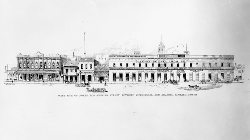
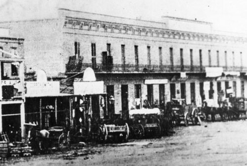


Los Angeles Street was lined with mostly commercial buildings; the southeast end of the business district around Los Angeles and 3rd streets was the Wholesale District. Only a few buildings were notable:


Cable car street railways in Los Angeles first began operating up Bunker Hill in 1885, with a total of three companies operating in the period through 1902,[173] when the lines were electrified and electric streetcars were introduced largely following the cable car routes. There were roughly 25 miles of routes, connecting 1st and Main in what was then the Los Angeles Central Business District as far as the communities known today as Lincoln Heights, Echo Park/Filipinotown, and the Pico-Union district.
Electrically-powered streetcar systems were numerous starting with the Los Angeles Electric Railway in 1887, but were over time consolidated into two large networks:
Angel's Flight and Court Flight were funicular railways operating from Broadway up Bunker Hill.


This is a map of the former and current buildings located in the Victorian business district of Los Angeles around 1890–1905.
Abbreviations and notes
Building numbering is according to the system introduced in 1890.[175]
To be read like a map:
Among the building permits issued by the Building Superintendent yesterday was one taken out by T. D. Stimson for a two-story building on the southwest corner of Broadway and Third street. The building is to be in size 120x120 feet. The estimated cost of the structure is $26,000.
The improvements in the Jones Block, opposite the Court House…are also part of the improvements
END OF AN ERA This is the old Lugo House on Los Angeles St., facing the Plaza, mainstay of 19 buildings which will be torn down, beginning today, to clear the area between Union Station and the Plaza. Some say the Lugo House was begun in 1811. Once it was a magnificent dwelling, later it became the center of the pueblo's social life and now, after -years of disrepair, it will die despite efforts of historical societies to save it.
This ordinance provides for the re-numbering of the houses of Los Angeles in such manner that all numbers under 100 shall be eliminated, thus changing the number of every house in the city… One hundred numbers, or as many thereof as may be necessary, shall be allotted to each block. No. 100 shall be the first number used at the respective beginning points on the sides of the streets which are to contain the even numbers, and 101 for the sides which are to contain the odd numbers… Number 120 now becomes 220, number 220 becomes 320, and so on throughout the entire city.
In the one-story adobe of Mascarel and Barri, on the corner of Commercial and Main streets, now the site of the United States National Bank, an Irishman named Samuel G. Arbuckle, who had come here in 1850 and was associated for a short time with S. Lazard, conducted a dry goods store. From 1852 to 1856, Arbuckle was City Treasurer. In the same building, and adjoining Arbuckle's, John Jones, father of Mrs. J. B. Lankershim and M. G. Jones, carried on a wholesale grocery business.
(1869)^ - Early view of Commercial Street, looking east from Main Street, just north of Temple Street, near the site of the later City Hall. On the right is Polaski and Goodwin's Dry Goods Store, sold to them by I.W. Hellman in 1868, and where the Farmers and Merchants Bank did business for years.
formerly the White House
…the New Arlington Hotel, formerly the White House, at the southeast corner of Commercial and Los Angeles…
At the northeast corner of First and Spring stood the Los Angeles First National Bank Building in 1887. This three story brick building, with a basement…
34°03′11″N118°14′38″W / 34.053°N 118.244°W / 34.053; -118.244


