
Loading article…
コミュニティカレッジ駅は、マサチューセッツ州ボストンにあるMBTAオレンジラインの高速鉄道駅です。チャールズタウン地区のオースティン通り沿い、ニューラザフォード通り(MA-99 )近くに位置し、州間高速道路93号線がザキム・バンカーヒル橋へと続く二層構造の高架下にあります。駅名は、隣接するバンカーヒル・コミュニティカレッジにちなんで名付けられました。この駅は1975年4月に開業し、チャールズタウン高架線のシティスクエア駅とトンプソンスクエア駅に代わる駅となりました。2005年頃にバリアフリー化されました。

コミュニティカレッジ駅は、ボストン市チャールズタウンの南西端、バンカーヒルコミュニティカレッジ(BHCC)のすぐ南、ニューラザフォードアベニュー(ルート99 )の西にある、二層構造の高架州間高速道路93号線の下に位置しています。[ 2 ]南西にはイーストケンブリッジとノースポイント開発地区があり、北西にはMBTA通勤鉄道保守施設とインナーベルト地区工業団地、南東には高速道路のランプがあります。
この駅には島式ホームが2つと線路が3本あります。現在使用されているのは西側のホームのみで、南行きの列車は西側の線路を、南行きの列車は中央の線路を使用します。東側のホームと線路は営業運転には使用されていません。駅の南端、線路の上には運賃支払い用のメザニンがあります。このメザニンは、オレンジラインとノースステーションへの進入路を跨ぐオースティン通りを通るギルモア橋の北側歩道に接続しています。また、歩道橋でメザニンとBHCC(ボストン・ヒル・コミュニティ・センター)も直接繋がっています。
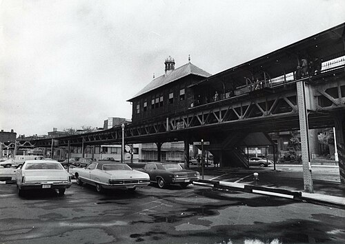
For much of the 19th century, the four major northside railroads (the Fitchburg, Boston and Lowell (B&L), Boston and Maine (B&M), and Eastern) did not share any trackage on the approach to Boston.[3] (Not until North Union Station in 1893 did they share a depot).[4] At that time, Charlestown was separated from East Cambridge by a large cove, Millers River. The Fitchburg crossed the B&M and the Eastern at Prison Point (then the site of a substantial state prison), near the modern location of Community College station. The Fitchburg and B&M had substantial freight depots nearby, and the B&M briefly had a Charlestown station around the 1850s.[3][5][4] For some period after the Fitchburg's Boston terminal replaced its Charlestown terminal in 1848, a flag stop was made at the Prison Point Bridge.[4][6]
The Charlestown Elevated section of the Boston Elevated Railway's Main Line opened in June 1901, with three elevated stations in Charlestown. The Thompson Square station was located one-third of a mile east of the current station along Austin Street at Main Street, while the City Square station was located half a mile south along Rutherford Avenue at Chelsea Street. The elevated was unpopular with many local residents, as it was noisy and blocked out sunlight to Main Street. In 1917, the elevated structure was slated to be replaced with a more permanent subway line along the same Main Street routing, but this project was canceled by the US's entry into World War I.[7]

In the late 1960s, the MBTA began work on the Haymarket North Extension project. It included a tunnel segment north from Haymarket through a new underground stop at North Station, then under the Charles River to a portal south of the Gilmore Bridge. From there, the extension was built along the Haverhill Line commuter rail right of way. Community College station was built to replace the two elevated stops nearby in Charlestown. The new route opened to Sullivan Square on April 7, 1975.[8] The Main Line had previously been renamed as the Orange Line in 1967, as part of a systemwide rebranding by the newly formed MBTA.
サリバン・スクエア駅やウェリントン駅と同様に、コミュニティ・カレッジ駅も、下り線用の2つ目の島式ホームと3つ目の急行線を備えて建設されました。この追加インフラは、オレンジラインのリーディングへの延伸計画で、同路線の通勤鉄道サービスを置き換えるために使用される予定でした(アンドーバーとヘイバーヒルへの通勤鉄道サービスは、ワイルドキャット支線経由で継続される予定でした)。しかし、メルローズの地元住民の反対により、オレンジラインの延伸はオーク・グローブで打ち切られ、急行サービスは運行されませんでした。2つ目のホームは、混雑するサリバン・スクエア駅とウェリントン駅では下り線用に開放されていますが、利用者の少ないコミュニティ・カレッジ駅では使用されていません。
ヘイマーケット北延伸線の他の 4 つの元の駅とは異なり、コミュニティ カレッジ駅にはバス専用レーンは建設されませんでした。イースト ケンブリッジのバス路線はすでに西のレックミア駅で終点となっており、チャールズタウンの92番線と93番線はすでに歴史的な路面電車のルートに沿ってヘイマーケット駅まで延伸されていました。[ 8 ]シティ スクエアで終点となっていた111番線と112番線はコミュニティ カレッジまで延伸されず、代わりに 111 番線はヘイマーケットまで延伸され、 112 番線はマーベリックまでルート変更されました。[ 8 ] 1975 年 12 月、92 番線の郊外行きは、BHCC と駅に停車するために、オースティン ストリートとスクール ストリートの間のラザフォード アベニューにルート変更されました。しかし、1977 年 12 月までに以前のルートに戻りました。 [ 8 ] [ 9 ] 1987 年、MBTA は駅に駐車場を建設することを検討しました。[ 10 ]
駅は元々バリアフリーではなかった。プラットフォーム間の歩道橋でアクセスできるメインプラットフォームへのエレベーターは、ビッグディグの一環として建設された。入札は2002年に行われた。[ 11 ]未使用の第2プラットフォームにはシャフトの骨組みが設置されたが、エレベーターの機械は設置されなかった。改修工事は2005年頃に完了した。[ 12 ]コミュニティカレッジ駅を含むオレンジライン全体は、メンテナンス工事のため2022年8月19日から9月18日まで閉鎖された。[ 13 ]入口広場のレンガの表面は、アクセシビリティを向上させるために2024年5月から6月にかけてコンクリートに置き換えられた。[ 14 ] [ 15 ]
{{cite web}}: CS1 maint: deprecated archival service (link)