
Loading article…
Toronto Harbour or Toronto Bay is a natural bay on the north shore of Lake Ontario, in Toronto, Ontario, Canada. Today, the harbour is used primarily for recreational boating, including personal vessels and pleasure boats providing scenic or party cruises. Ferries travel from docks on the mainland to the Islands, and cargo ships deliver aggregates and raw sugar to industries located in the harbour. Historically, the harbour has been used for military vessels, passenger traffic and cargo traffic. Waterfront uses include residential, recreational, cultural, commercial and industrial sites.
There are two harbours: the original natural harbour, today named the "Inner Harbour", and the "Outer Harbour". Access into the Inner Harbour is made via either the Western Gap or Eastern Gap. The Don River drains into the Inner Harbour from the north-east, through the Keating Channel.
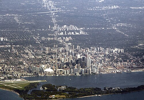
The makeup of the soil between the mainland and the island varies depending on the area of the harbour. Near the Western Gap (the western access point to Toronto's Inner Harbour), the sediment is made up of stone, whereas sand makes up the sediment near Billy Bishop Island Airport, and the western parts of the Toronto Islands' north shore. Clay is more prominent in near the centre of the harbour, whereas the soil turns to mud near the north shore, towards the mouth of the Don River.
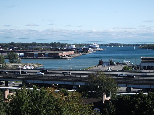
The Inner Harbour is used by pleasure boats and commercial vessels. The Port of Toronto is operated by PortsToronto and is located on the eastern shore of the harbour. The port consists of cargo facilities and the International Marine Passenger Terminal, a passenger ship dock on the eastern shore. The north shore has a mixed range of uses including Harbourfront, a conversion from industrial land to recreational and cultural uses. Harbourfront has parks, hotels, an amphitheatre, and many other facilities. The north shore retains one port-related industrial use, the Redpath Sugar Refinery, while most of the lands have been converted to other uses. The Jack Layton Ferry Terminal is located at the foot of Bay Street and pleasure and party cruise boats dock along the shore to the west of York Street.
トロント諸島は、トロントのダウンタウン沖合に位置する小さな島々の連なりで、内港の防波堤としての役割を果たしています。島の大部分は公園として整備されていますが、ボートクラブ、遊園地、空港、そして小規模な住宅地も存在します。

ウェスタンギャップは、内港への西側からのアクセスを可能にする幅120メートル(390フィート)の水路です。この水路は、大型船(湖水貨物船など)が内港に出入りできるほど十分に深く(31メートル以上)、十分な深さがあります。 [ 2 ]ビリー・ビショップ・トロント・シティ空港は水路の南側に位置し、フェリーとトンネルでアクセスできます。1910年にウェスタンギャップが掘削される前は、水路は広く、後にハンランズポイントとなる場所の周囲には浅い砂州がありました。砂は新しい水路の両側に堆積し、空港用地の一部となっています。
イースタンギャップは、ウォーズ島とポートランズの西端の間にある幅約200メートル(660フィート)の海峡で、ほとんどの貨物船が内港や港湾施設に入る際に利用している。この海峡は、1852年から1858年にかけて嵐によって、この地域と本土をつないでいた砂嘴が切れたことで初めて形成された。
1800年代以前は、小型ボートの利用者はオンタリオ湖から内港まで、砂嘴半島の西端にある陸路を通らなければならなかった(そのため、陸路を少し移動する必要があった)。1858年以降、港湾管理局は仮設の水路を恒久的な水路に整備した。
トロントには、アウターハーバーと呼ばれる2つ目の港もあります。アウターハーバーの北側に位置するトロント市のチェリービーチ(旧クラークビーチパーク)は、夏には人気があります。ここは通常、高い水質、環境、安全基準を満たしています。 [ 3 ]ウォーターフロント・トロントが提案している全長37キロメートル(23マイル)のオンタリオ湖公園は、アウターハーバーを通過する予定です。[ 4 ]トロント市は、港の東端にマリーナを運営しています。独立したアウターハーバーセーリング連盟を構成する8つの地域ウォータースポーツクラブが、チェリービーチ・クラークビーチパークの東側の小さな一帯を共有しています。[ 5 ]

The harbour was developed in the 1950s and 1960s by the Toronto Harbour Commission through the construction of a new breakwater called the Outer Harbour East Headland. At that time, it was expected that there would be a great upswing in the number of ships calling at Toronto once the Saint Lawrence Seaway opened. However, the need for an extra harbour never materialized, and private boats are the only traffic usually found there now.
Gaasyendietha is a legendaryLoch Ness Monster-type creature and it is sometimes spotted in Lake Ontario and even within the Toronto Harbour. The story of Gaasyendietha is a Native Canadianmyth from the Seneca tribe.[6]
The original shoreline of the northern shore was low sandy bluffs, just south of today's Front Street. The mouth of the harbour pointed west. The islands used to be a low sandy peninsula forming the southern limit of the bay. The Scarborough Bluffs are much larger bluffs that lie approximately 6.2 mi (10.0 km) east of the harbour. Strong lake currents over time washed the sand eroded from the bluffs westwards to form the peninsula surrounding the bay. The eastern shore of the bay, approximately six kilometres east, was a marsh around the mouth of the Don River. In addition to the Don River, a number of smaller creeks flowed into the bay. The original site of the town of York had half a dozen short creeks that flowed through it.
The town of York was established in 1793 in a ten-block rectangle bounded by the present Front Street, Berkeley, Duke (now Adelaide) and George Street alongside Taddle Creek. A government wharf was built to handle the transfer of ships' cargoes. A garrison at the entrance to the harbour, at the mouth of Garrison Creek, was established to guard the harbour along with a blockhouse on the island. In 1801, York became an official port-of-entry for immigrants and cargo. In 1808, the Gibraltar Point lighthouse was built on the island to guide ships.[7]

In the early 19th century, cargoes destined for York would be transferred at Montreal to smaller boats such as Durham boats and batteaux to traverse the rapids of the St. Lawrence River. Although not fully established by the War of 1812, the British colonial army was determined to set up boat-building for the defences at York. Fort York, on the north shore of the bay, near the mouth of Garrison Creek, guarded the harbour's mouth. An armed schooner was under construction at the York Naval Shipyards when the Americans attacked and the British burned the hull rather than surrender it. The invaders occupied Fort York, looted the town and destroyed military facilities.[8]
In 1825, the Lachine Canal was built to bypass the Lachine Rapids. Some of the boats used for cargo were now being built at Toronto Bay. By the time of the establishment of the Town of Toronto, three large wharves existed for shipping, King's Wharf at Peter Street, Cooper's Wharf at Church Street and Merchant's Wharf at Caroline Street (today's Sherbourne Street). The new Queen's Wharf, at the foot of Bathurst Street, was constructed in two stages, eventually reaching 244 feet (74 m) in length. Commissioned by the Province of Upper Canada, it cost £4,500. The first harbourmaster of Toronto, Hugh Richardson, was named in 1833. Richardson held the position until 1870.[9] While the Queen's Wharf no longer exists, the Queen's Wharf Lighthouse still exists, eventually moved to a location off today's Lake Shore Boulevard in 1929.[10] In 1849, the Harbour Trust was formed to manage the port and the Queen's Wharf.[11]
In 1832, the Gooderham and Worts Distillery went into operation, using a windmill on the Toronto waterfront, near the Don River, to provide power. The Distillery had been conceived as a plant to make flour, but the distillery business was much more popular. By 1837, the mill was producing more than 28,000 US gallons (110,000 L) of whiskey annually.[12]
By 1840, the entire waterfront was populated with government and merchant wharves. The Esplanade, a 100 feet (30 m)-wide road, was proposed, just south of Front Street, with new water lots made from cribbing and filling of the shore to the south. The waterfront was extended to a survey line from the point of the Gooderham windmill west to a point due east of the old Fort Rouillé.[12] Ostensibly for carriages and carts, the roadway eventually became primarily the route for rail lines in the central core. In exchange for 40 feet (12 m) of the Esplanade, the railways underwrote the infilling of the harbour. The Esplanade and infill project was complete by 1865.[13] A section of The Esplanade from Yonge Street to Berkeley Street still exists as a roadway and park. The rail lines moved to a viaduct in the 20th century.
The harbour saw increased activity in the 1840s. Harbour dues increased by 25 per cent between 1843 and 1844 alone. This saw an increase in the number of ships using the harbour. Donald Bethune operated a fleet of eight steamships out of Toronto harbour.[14]
The peninsula became the Toronto Islands through the result of two storms and man-made activity. In 1852, a storm created a channel through the eastern edge of the peninsula that formed the south edge of the bay. The storm washed through excavations made for sand for local construction. In 1858, another storm widened the channel and made it permanent.[15]
The first rail line to the harbour was the Ontario, Simcoe and Huron Railroad in 1853. The next rail line was the Grand Trunk, which underwrote the Esplanade project in exchange for an easement to enter the City. The Canadian Pacific Railway arrived in 1886, through the purchase of the Credit Valley Railway.[16] Most of the area along the shoreline was connected to the railways. Manufacturers of products such as soap received raw materials via boat, produced the product at their location on the harbour, and distributed it via rail.
As well as cargo, the harbour also became a major passenger waypoint. By the 1880s, the harbour was handling 1,250,000 passengers annually through passenger steamship docks at the foot of Yonge Street. Passenger boats operated on Lake Ontario and the St. Lawrence River. Excursions to Niagara also departed from the Yonge Street docks.[15]


西側の水路の水深は、1906年に蒸気バージ「レゾリュート」が嵐で港の外で沈没した時点で浅すぎることが判明した。バージは港に避難することができなかった。クイーンズワーフ地区は、1908年から1911年にかけて連邦政府によって再建された。既存の水路は底が固い岩盤であったため、より浅く浚渫することができなかったため、既存の水路の南1,300フィート(400メートル)に、より深い新しい西側の水路が掘られた。 [ 17 ]新しい水路のために取り除かれた砂によって、合計45エーカー(18ヘクタール)の新しい土地が作られ、新しい水路の南北に均等に分割された。[ 18 ]クイーンズワーフの敷地は、最終的にバサースト通りとフリート通りの交差点にあるロブロウズ倉庫の敷地となった。 2010年代に行われたロブロウズ倉庫の再建工事中に、クイーンズ・ワーフ地区の埋め立て時に埋め立て地に放置されていた古いボートが発見された。

1910年のトロント商工会議所によるアシュブリッジ湾の提案は、鉄道線路でアクセスできる工業事務所や敷地、キーティング海峡の南からイースタンギャップまでのドック施設に隣接する公共倉庫、南端の公園/レクリエーション用地のための工業地区であった。[ 19 ] 1911年にトロント港湾委員会が設立された。トロント市が所有していたウォーターフロントの土地は、管理のために委員会に移管された。1912年、委員会は西のハンバー川から東のウッドバイン通りまでの港とウォーターフロントの最初の計画を提出した。委員会は、新しいウェランド運河に合わせて港を24フィート(7.3メートル)の深さまで浚渫した。 [ 20 ]
トロント市が拡大するにつれて、湾の北岸は埋め立てによってさらに改変され、約500 メートル (550ヤード)南に移動しました。エスプラネードの埋め立てに続いて、1910 年の 2 番目の埋め立てプロジェクトでは水域が埋め立てられ、現在のレイク ショア ブールバードの南に海岸線が拡張され、ターミナル ウェアハウス、トロント港湾委員会ビル、および新しいクイーンズ キー沿いの他の施設のためのスペースが確保されました。[ 21 ]北岸の最後の埋め立ては 1950 年代に行われ、ヨンゲ ストリートから東のドン川まで埋め立てられ、レッドパス シュガー リファイナリー、ビクトリー 大豆工場、およびいくつかの海上ターミナルのためのスペースが確保されました。
In the 1920s, most of the low-lying marsh of Ashbridge's Bay was filled in to create Toronto's inner harbour area (with the small section to the east and the shipping channel the only reminder of the body of water). In the 1930s, the waters of Hanlan's Bay on the western point of the islands were infilled to create the Toronto Island Airport.

By the time that the plans to build the St. Lawrence Seaway were announced, commercial usage of the harbour was already in decline. The previous infill on the eastern side created in the 1920s was used to build modern port facilities. In the 1970s, the northern shore was in decline and there was a new political initiative to rebuild the waterfront without industry in a manner seen in other cities. The Harbourfront project expropriated the lands west of York Street. Several facilities were renovated, such as the Terminal Warehouse, and others were demolished, creating space for recreational and cultural uses. The area around Yonge Street remained in private possession and a hotel and condominiums were built on the shoreline. The area east of Yonge Street remained in light industrial use under public possession. On the north side of the harbour, there are a few buildings left from the industrial period. Some are in use, such as the Redpath Sugar Refinery. Others have been demolished or are slated for demolition, including grain storage elevators at the east and west end of the inner harbour.
Starting in 1972, the Government of Canada spent CA$10 million ($75 million in 2025 dollars)[22] to dredge and widen the Eastern Gap, making it the primary entrance to the harbour for commercial boats. The 10 billion cubic yards (7.6×10^9 m3) of material was used to build the aquatic park on the Outer Harbour headland.[23]

In June 2004, the company Canadian American Transportation Systems (CATS) began regular passenger/vehicle ferry service between Pier 52 and Rochester, New York using the vessel Spirit of Ontario I. The service used a marketing name called "The Breeze". While Rochester had a custom-built ferry terminal, the Toronto terminal was a temporary facility, near the end of Cherry Street for security and customs screening facilities while a permanent marine passenger terminal was still under consideration for construction. CATS discontinued the service after only 11 weeks; among the problems cited was the absence of a permanent marine passenger terminal in Toronto and little Canadian interest in the service. The vessel was sold in a bankruptcy sale in February 2005 to Rochester Ferry Company LLC, a subsidiary of the City of Rochester. In April 2005, Rochester Ferry Company LLC announced that the Rochester-Toronto ferry service using Spirit of Ontario I would return, operated by Bay Ferries Great Lakes Limited and using the marketing name The Cat. The Toronto Port Authority officially opened the International Marine Passenger Terminal on June 27, 2005, three days before ferry service resumed.[24] Even with impressive passenger numbers by the winter of 2006 the ferry service lost funding from the City of Rochester and announced that it would no longer be in business. The terminal building was later used for filming the CBC crime drama The Border.

In 2018, Waterfront Toronto began construction on the Don River Mouth Naturalization, which will create another outlet for the Don River into Toronto Harbour. Essroc pier has been demolished and Polson Pier will be demolished. The bank on the harbour in these areas will be turned into parkland. A regulatory flood channel will spill into the Ship Channel. The project will be completed in 2024.
The original area of the harbour in 1834 was estimated to be about 2,150 acres (870 ha). With infilling, the area has declined to an area of 1,210 acres (490 ha) in size.[25]
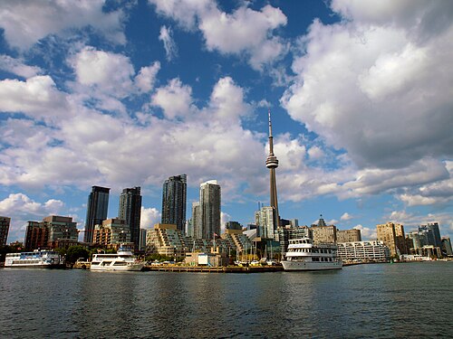
Wharves existed along Toronto's waterfront in the 19th century, but they have since been replaced by quays. Most of the former wharves disappeared when the waterfront was filled in along with the now "missing" creeks of Toronto. A list of current quays/slips along the waterfront:
中央ウォーターフロント沿いの旧埠頭一覧:
トロント港で発見された、またはトロント港に関連する船舶には以下が含まれます。
私は、GTA内外から乗客が満員の、ショーボート風のジュビリー・クイーン号に乗船しています。