
Loading article…
47°30′N93°4′W / 47.500°N 93.067°W / 47.500; -93.067
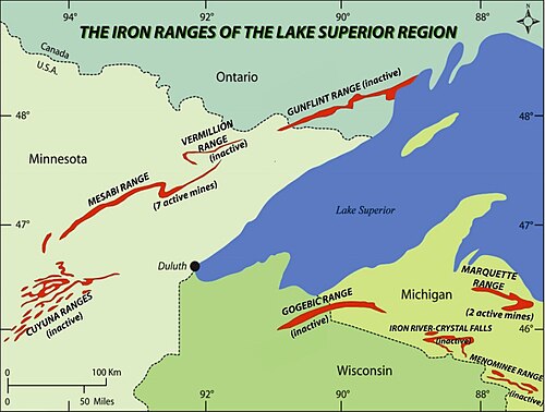
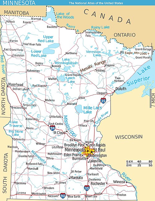

The Mesabi Iron Range is a mining district and mountain range in northeastern Minnesota following an elongate trend containing large deposits of iron ore. It is the largest of four major iron ranges in the region collectively known as the Iron Range of Minnesota. First described in 1866, it is the chief iron ore mining district in the United States. The district is located largely in Itasca and Saint Louis counties. It has been extensively worked since 1892 and has seen a transition from high-grade direct shipping ores through gravity concentrates to the current industry exclusively producing taconite pellets. Production has been dominantly controlled by vertically integrated steelmakers since 1901 and therefore is dictated largely by US ironmaking capacity and demand.
The Mesabi Range was known to the local Ojibwe as Misaabe-wajiw ('Giant mountain').[1][2] Throughout the Mesabi Range, Mesaba and Missabe spelling variations are found along with places containing Giant in their names.
There are four iron ranges in northern Minnesota: the Cuyuna, the Vermilion, the Mesabi, and the Gunflint. Most of the world's iron ore, including that contained in northern Minnesota, was formed during the middle Precambrian. During this period, erosion leveled mountains. This erosion released iron and silica into a shallow water marine environment. Algae living in this sea raised the level of oxygen, creating an oxidizing atmosphere known as the Great Oxidation Event. This oxygen catastrophe caused the eroded iron to precipitate into the banded iron formations found in northern Minnesota and other members of the Animikie Group. Over billions of years, geological forces left behind ore deposits of varied quality and concentrations – differences that would determine how the ore was mined from place to place. On the Mesabi Range, soft ore lay close to the surface where it could be scooped from open-pit mines.[3]
The overall structure of the range is that of a monocline dipping 5 to 15 degrees to the southeast. Key faults include the Calumet, La Rue, Morton, Biwabik, and the Siphon. The Duluth Gabbro complex to the east has caused metamorphic changes in the Biwabik formation. The natural iron ores and the magnetite taconites occur in this Precambrian Biwabik formation, which is a cherty layer 340–750 feet (100–230 m) thick. The natural ores are located in elongated channels or tabular deposits, while the magnetite taconites occur in stratigraphic zones. Natural ores have an iron content of 51 to 57 per cent while the taconites are 30 to 35 percent iron, which are beneficiated to pellets contain 60 to 67 percent iron. The natural ores are mainly mixtures of hematite and goethite.[4]:519–520,522,527–528 The most common silicate is Minnesotaite. Also of note are the presence of algal structures in the Biwabik formation.[5]
The Mesabi Range is 110 miles (180 km) long. Heights vary from 200–500 feet (61–152 m). The highest point, located about 5.6 miles (9.0 km) northeast of Virginia, is Pike Mountain at 1,950 feet (590 m).[6] The range trends from the northeast to the southwest, extending from Babbitt to Grand Rapids.[7]
The Embarrass Mountains are a small subrange of the Mesabi Range, spanning about 9 miles (14 km) through northern White Township and Hoyt Lakes in St. Louis County. Heights vary from 200–400 feet (61–122 m).[8] The highest point, at 1,940 feet (590 m), is roughly 1.9 miles (3.1 km) west of the unincorporated community of Hinsdale,[6] near the former Erie Mining Company's pits and taconite processing plant.
Iron-bearing rocks were noted by the Minnesota State Geologist Henry H. Eames in 1866.[9] Iron ore was discovered north of Mountain Iron on November 16, 1890, by J. A. Nichols of the Merritt brothers. The range was defined by 1900. Initially underground mines were employed, but these gave way to open pits so that by 1902, half the operations were conducted this way. The last underground mine closed in 1960.[10] Natural ores eventually gave way to iron-ore concentrates from magnetite taconite so that by 1965 one third of production came from these pellets.[4]
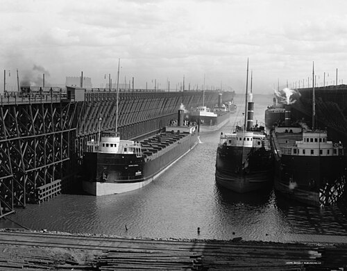
Much of the softer ore was formed close to the surface, allowing mining operations to be conducted via open pit mines. The world's largest open pit iron ore mine is the Hull–Rust–Mahoning Open Pit Iron Mine in Hibbing. In the early years of mining from the late 19th century until the 1950s, mining focus was on high grade ore that could be processed into steel without much change. However, when that supply dried up, focus shifted to lower-grade ore (taconite) which requires extensive processing at large mining-processing facilities before moving to port. The mined ore is then transported, primarily by the Canadian National Railway, to the ports of Two Harbors and Duluth, and by BNSF Railway to Superior, Wisconsin. At Duluth, trains of up to eighty 100-ton open cars are moved out on massive ore docks to be dumped into lake freighters with tonnages of up to 60,000 for shipment to steel mills in Indiana and Ohio.
Dormant and exhausted open pit mines are a common feature along the Iron Range. Some of these sites have been redeveloped for other uses. For instance, the Virginia Pilot is a project which focuses on redeveloping the grounds adjacent to the old mines into low- to moderate-income residential space. The Hill-Annex Mine became a state park and offered tours to visitors who wished to learn about mine operations. The park was closed in 2024 as mining had become feasible again.
Currently, there are six mining-processing facilities in operation on the Iron Range. Cleveland-Cliffs owns and operates Northshore Mining, which has mining operations in Babbitt and crushing, concentrating (grinding) and pelletizing operations in Silver Bay, along with United Taconite which has mining operations in Eveleth and crushing, concentrating and pelletizing operations in Forbes. Arcelor Mittal owns and operates the Minorca Mine and Plant with mining operations near Biwabik and Gilbert and a crushing, concentrating and pelletizing facility near Virginia. United States Steel owns and operates both KeeTac and Minntac with mining and processing facilities in Keewatin and Mountain Iron respectively. Hibbing Taconite operates a mine and plant between Hibbing and Chisholm.
メサビ・メタリックス社は、タコナイトを採掘・加工するためにナシュウォーク近郊に鉱山/プラントを建設中です。 [ 11 ]スティール・ダイナミクス社と神戸製鋼所は、かつてホイトレイクス近郊のメサビ・ナゲットを所有・運営していましたが、自社で採掘するのではなく、購入した鉄鉱石精鉱から高鉄含有量のナゲットを生産していました。マグネテーション社は、かつて自社設計の高出力磁気分離器で尾鉱から回収した鉄鉱石精鉱を生産し、世界中に販売・出荷していました。


ジョン・D・ロックフェラーは以前、弟のフランク・ロックフェラーとフランクのビジネスパートナーであるジェームズ・コリガンに、メサビ山脈で操業していたフランクリン鉄鉱山会社への出資資金を貸し付けていた。1896年末か1897年初頭までに、ジョンはコリガンが融資を返済できなかったため、コリガンの株式を取得した。フランクとコリガンは会社を売却せざるを得なかった。[ 12 ]当時、メサビ山脈の鉱石の市場はほとんど存在しなかった。アメリカの製鉄炉は、その粉状の性質に対応できるように作られておらず、製鉄業者はそれを質の悪い鉱石だと考えていたからである。ジョンはメサビ鉱山と輸送事業を構築するために4000万ドルを投資した。ピッツバーグの製鉄業者に届けるには、鉱石は五大湖を渡ってクリーブランドまで運ばなければならなかった。彼はメサビ山脈からスペリオル湖のダルースまで鉱石を輸送するための鉄道に200万ドルを投資した。
1896年までに、彼はメリット兄弟の持株会社であるレイク・スペリオル・コンソリデーテッド・アイアン・マインズ・カンパニーを支配下に置いた。彼は鉱石運搬船団を建造した。1896年12月、彼はピッツバーグのヘンリー・W・オリバーとアンドリュー・カーネギーと、鉱石採掘や輸送事業に参入しないこと、そしてロックフェラーが鉄鋼事業に参入しないことで合意した。鉄鋼業者はメサビ山脈からの鉱石を処理するために製鉄所を改造した。オリバーはこの合意を破棄し、それに対してロックフェラーは五大湖での鉱石運搬船の独占権を獲得した。ロックフェラーは、1901年にモルガンがカーネギーの鉄鋼権益を買収した直後に、西部の鉱石保有権をJPモルガンに9000万ドルで売却した。 [ 13 ] [ 14 ]

Several large-scale strikes took place on the Mesabi Iron Range during the early 20th century. The first began on July 20, 1907 after the Western Federation of Miners asked Oliver Iron Mining Company for, among other demands, an eight-hour work day and a pay raise. The strike lasted two months and resulted in thousands of workers being blacklisted.[15]
On June 25, 1916, a miner left his shift after being paid less than the contracted rate. His action led to the Mesabi Range strike of 1916. The Industrial Workers of the World quickly supported the strike for better pay and shorter hours. In September 1916, the workers voted to resume work, assuming a failed strike. However, shortly after returning to work a 10% raise in wages was issued for workers throughout the range.[16]
The Mesabi Iron Range continues to play a central role in the economy and identity of northeastern Minnesota, although the region has undergone economic and demographic shifts since its peak mining years in the early 20th century. Iron mining remains active, with major companies including Cleveland-Cliffs and United States Steel operating taconite mining and processing facilities across the range.[17]
Economic diversification has become a regional focus, with investments in health care, education, renewable energy, and tourism. Attractions such as the Minnesota Discovery Center in Chisholm, the Hull–Rust Mine View in Hibbing, and the Mesabi Trail draw visitors interested in the region’s mining heritage and natural landscape.[18]
Redevelopment of former mine lands is also underway. In Virginia, the Rock Ridge Public Schools campus and the Virginia Pilot housing project are located on reclaimed mining sites.[19] Similar efforts across the Range have converted former pits and tailings basins into parks, trails, and new residential areas. Examples include the Bruce Mine Headframe, Buhl Disc Golf Course, and West Two Rivers Recreation Area.
Like many rural areas in the Upper Midwest, the Iron Range faces demographic challenges, including an aging population, youth outmigration, and overall population decline.[20] Regional agencies, such as the Iron Range Resources and Rehabilitation Board, have implemented workforce development and housing incentives to attract new residents and retain workers.
Culturally, the Iron Range retains strong ties to its labor and immigrant history, which are reflected in events such as the annual Iron Range Labor Day picnic, local ethnic festivals, and active historical societies. In recent years, the region has experienced a political shift, with many traditionally Minnesota Democratic–Farmer–Labor Party-leaning communities increasingly supporting Republican candidates in statewide and federal elections.[21]