
Loading article…
Ubay, officially the Municipality of Ubay (Cebuano: Munisipyo sa Ubay; Tagalog: Bayan ng Ubay), is a municipality in the province of Bohol, Philippines. According to the 2024 census, it has a population of 82,179 people.[7]
Ubay has an uncontested area of 258.132847 square kilometers (25,813.2847 hectares) and has a contested area of 5.87 square kilometers (587.8688 hectares) with other Municipality per certification issued by the Land Management Bureau(LMB) of the DENR. It has a 61-kilometer (38 mi) coastline.[8]
One etymology derivation is that the town's name is a contraction of the term ubay-ubay, meaning "alongside".[8]
According to Kaufmann's Visayan-English dictionary,[9] the Visayan word "ubay" means:
The flow of seawater between the mainland and the island of Lapinig Grande (now Pres. C.P. Garcia town) could justify the second definition of Ubay. It is a situation that is permanent and the constant reference to the flow of water can make the term ubay be attached as the name of the place.[10]
An alternative derivation is that the term 'ubay-ubay' or 'alongside' became the byword of seafarers who used to travel close to the shorelines of Ubay to avoid the strong current of the Canigao Channel.[11] There was a single path to follow reach the island trading centres. This trail was located alongside (ubay) the sandy beach. Later on the term Ubay became the original name of the community.
Historically, Ubay was part of Talibon, when the latter was established as a town in civil aspect in 1722.[1] During Spanish period, a town has two aspects - religious, headed by the parish priest and civil aspect, headed by a gobernadorcillo. The religious aspect was then considered superior to the civil aspect, as the church held significant influence over daily life and governance during that time.[12]
In 1744, the Dagohoy Revolution started, controlling the entire northeastern part of the province, stretching from Duero to Inabanga that lasted up until 1829. As the revolution progresses, Jesuit were replaced by Augustinian Recollects in Bohol in 1768 led by Fr. Pedro de Santa Barbara, who travelled through mountains with proposals of peace and resettlement for Dagohoy and its followers. Through his untiring intrepidness, later on, pacified patriots together with their cluster chieftains chose to resettle in southern coastal towns. Later in 1794, Fr. Manuel de la Consolacion, then parish priest of Inabanga, successfully brought hundreds of followers and resettled them in towns of Talibon and Inabanga, as well in the barangays (villages) of San Pedro (Talibon), Pangpang (Buenavista), and Ubay.[13] Therefore, much of early residents of Ubay were followers of Dagohoy.
In 1821,[1] Ubay became an independent town from Talibon in civil aspect, but due to the Dagohoy Revolution, the newly established town of Ubay did not operate as an independent town because most of the inhabitants resisted the Spanish Government. Up until 1846, Ubay was not listed among the towns in the island of Bohol.[14] Then, according to a Tax Census dated September 1, 1847,[15] Ubay was officially listed, which served as the basis for its reorganization and indication of a functioning town, marking September 1, 1847[15] as the foundation date of Ubay. The first gobernadorcillo of Ubay was believed to be Toribio Reyes, whose name and the year 1872 are inscribed on one of the old church bells of Ubay Parish (Parroquia de Ubay), and who was the only son of Berudja, the legendary matriarch of Ubay.
The religious aspect of Ubay was still administered by the parish of Inabanga, until Talibon was able to establish a separate parish in 1831,[16] making Ubay a visita with its chapel made of wood. The official religious aspect of the town was established much later than the civil aspect.
On June 26, 1874, a written petition[17] was made by gobernadorcillo Saturnino Boyles along with the Community Heads, and the Household Heads of Ubay for an independent parish, separate from Talibon. To support their cause, they voluntarily constructed a decent rectory.
そして 1877 年 10 月 22 日、聖子の保護のもとに教区令によりウバイに独立教区(スペイン時代: Parroquia de Ubay、現: Santo Niño de Ubay Parish)が設立された[ 16 ] [ 17 ]。これは、スペイン国王アルフォンソ12世が発行した1876年10月5日付けの海外省勅令第695号[ 10 ]、ウバイに独立教区を設立すること、および1876年11月22日付けのスペイン総督ホセ・マルカンポ(第3代サン・ラファエル侯爵)からの確認布告によってなされた。カブラオ (現在はマビニのサンロケ) もその訪問地に含まれていました。[ 16 ]
Parrioquia de Ubay (現 Santo Niño de Ubay) の初代教区司祭は、P. 神父でした。ブラス・アダン・デル・ピラール、アウグスティヌス回想勲章出身。セブ島のコンソラシオンに転勤するまで、1877年10月から1884年2月まで奉仕した。[ 18 ]彼の後継者は神父であった。ベニート・ガラヤオ・デル・カルメン、1884年2月から1886年2月。 P.神父フランシスコ・ベガ・デ・ラ・ビルヘン・デ・ヴィコ、1884年11月9日から1890年4月まで。 P.神父レオン・インチャウスティ・デル・ロザリオ、1890年2月26日から3月20日まで。 P.Fr.ブエナベントゥラ マロダン デル カルメン、1890 年 3 月 20 日から 1897 年まで。そしてP.神父。フアン・ベア・デ・ラ・ビルヘン・デル・ビジャール、1897年5月14日から1898年12月20日まで。[ 19 ]
ウバイでは毎年1月に町のお祭りが行われます。これはサント・ニーニョの公式な祝祭月であるためです[ 20 ]。この伝統は今日まで続いています。遠く離れたウバイの人々は、お祭りの期間中に故郷に戻り、お祝いをしたり、愛する人々と再会したり、自分たちの文化遺産を称えたりします。町はパレード、音楽、宗教儀式で活気に満ち、地域の人々が集まって伝統を追体験し、故郷との絆を強めます。
1902年3月6日、バトゥアナン市(現在のアリシア)全体がフィリピン委員会法第370号によりウバイ市と統合された[ 21 ]。
1903 年 10 月 31 日、旧イピル市 (現在のトリニダード) は 2 つに分割されました。イピル川を境界線として、左岸はタリボンに併合され、右岸はウバイと統合されました。さらに、カブラオ村と以前併合されていたバトゥアナン市は、リバス村、カンディジャイ村とともにウバイから分離され、フィリピン委員会法第 968 号により、マビニ市という新しい独立した市が創設されました。 [ 22 ]
On September 1, 1947, the municipality of Ipil was reorganized, joining the barangays of Guinobatan, Mahagbu, and Tagum from Ubay together with other barangays of Talibon to create the renamed municipality of Trinidad through Executive Order No. 80.[23]
On June 21, 1956, barangay Babag separated from Ubay together with other barangays of Carmen, Sierra-Bullones, and Trinidad to form the new municipality of Dagohoy through Executive Order No. 184.[24]
On March 14, 1961, barangays of Corazon and Magsaysay separated from Ubay together with other barangays of Trinidad to form the independent municipality of San Miguel through Executive Order No. 423.[25]
On December 29, 1961, barangay San Isidro (not the present San Isidro, Ubay) separated from Ubay, together with other barangays of Candijay, Guindulman, and Sierra-Bullones to create the municipality of Pilar through Executive Order No. 460.[26]
On June 21, 1969, barangays of Aguining, Basiao, Bonbonon, Gaus, Pitogo, and Tugas separated from Ubay to create the independent municipality of Pitogo in virtue of Republic Act 5867.[27] It was later renamed President Carlos P. Garcia in honor of the 8th president of the Philippines on October 27, 1977, through Presidential Decree No. 1228.[28]
Ubay is the largest municipality of Bohol with a total land area of 258.13 km2, encompassing about 5.35% of the total land area of the province. In 1902, during the American Colonial period, Ubay covered almost the entire northeast portion of the province, about a fifth of its total land area. Below is the list of former territories under the jurisdiction of Ubay.
Ubay is the largest and most populated municipality in Bohol, located in the northeast of the province. The town is situated east of Trinidad, north of Alicia and Mabini, and northeast of San Miguel. It is 130 kilometres (81 mi) northeast of Tagbilaran.
The climate is typically equatorial – temperature range over the year is less than three degrees Celsius (5.4 deg F), and annual rainfall exceeds 1,500 millimetres (59 in). The dry season starts in February and lasts through April sometimes extending to mid‑May. The climate in Ubay falls within Coronas climate type IV, characterized by not very pronounced maximum rainfall with a short dry season from one to three months and a wet season of nine to ten months.[45]
Ubay has a tropical climate. Most months of the year are marked by significant precipitation, making agriculture favorable – it supports at least two rice crops per year. The short dry season has little impact. Ubay is classified as Am (Tropical monsoon climate) by Köppen–Geiger climate classification system.

Ubay is politically subdivided into 44 barangays (villages). Each barangay consists of puroks and some have sitios.
These barangays are organized into eight urban districts (UD):
1903年に最初の国勢調査が行われた際、この自治体の人口は7,355人でした。その後も人口は増加を続け、1960年には34,090人に達しました(この期間の年間成長率は2.73% )。1970年に、かつて構成バランガイであったカルロス・P・ガルシア大統領自治体が設立されたことにより、人口は著しく減少しました。1970年以降の平均年間成長率(1970年~2020年)は1.85%です。
主要言語はセブアノ語です。フィリピン語と英語は限られた範囲で理解されます。
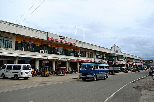
ウバイには、小売業や卸売業に従事する商業貿易会社など、多くの事業所があります。新しい公設市場の建物は2000年に完成しました。通常の市場開催日は月曜日で、近隣の町から地元の商人がやって来て、主に農産物や、古着、家庭用品、その他の製品などの小型消費財を販売します。ウバイはまた、近隣の島嶼自治体であるプレジデント・カルロス・P・ガルシア、ビエン・ウニド、アリカ、マビニの市場も提供しています。もう1つの有名な公設市場は、自治体の南にあるサン・パスクアル地区にあります。 [ 58 ]
ウバイは、同州の成長拠点の一つであり、酪農の中心地とみなされています。ウバイ町には、フィリピン水牛センター(PCC)、国立酪農庁(NDA)、そして国内最大かつ最古の畜産農場であるウバイ畜産農場(3,000ヘクタール以上)があります。また、ウバイ町は農業工業生産の中心地でもあり、ロマンゴグ地区にあるマルセラ・ファームズ社(アルトゥラス・グループ)が生産する鶏肉などの鶏肉製品は、中部ビサヤ地方で最大規模を誇ります。さらに、ウバイは1,000ヘクタール以上の養魚池を有し、魚製品の主要生産地の一つでもあります。この自治体は農業の中心地であり、フィリピンココナッツ庁(PCA)、水産資源局(BFAR)、ボホール実証試験場(BES)、土壌水管理局(BSWM)、中央ビサヤ総合農業研究センター(CENVIARC)などの政府機関が所在しています。また、この自治体は州の米どころとしても知られており、総面積の51%が農業用地として利用され、その水田の大部分は灌漑されています。


ウバイは、ニュージーランドの風景を彷彿とさせるウバイ畜産農場の牧草地や水牛、牛の姿、そして農業省の施設を訪れることで得られる学習体験などから、エコ・アグリツーリズムの中心地と言えるでしょう。
セブのシヌログ祭と同様に、ウバイウバイ祭は守護聖人であるサント・ニーニョを称える町独自の祭りです。この色彩豊かで魅力的な祭りは、多くの人が町の主要道路や会場に集まり、盛大なストリートパレードや祭りのダンスコンテストを見物する、大変賑わうイベントです。この祭りは毎年1月の最終金曜日に開催されます。[ 59 ]

ウバイ市は、市長が市の長として統治している。副市長は市長に次ぐ地位であり、市議会の議長を務める。
近隣のバランガイ間では、最も一般的な交通手段は三輪タクシーです。遠方のバランガイ間では、オートバイが最も一般的です。すべてのバランガイは道路で結ばれており、道路がないのは中央山脈の急斜面だけです。
ボホール環状道路と港湾施設の整備により、ウバイはボホール島北東部の貿易・輸送拠点となり、隣接するレイテ島やボホール州の他の地域と結びつくようになった。これらの目的地への旅客および貨物輸送量は年々著しく増加しており、これらの地点間の貿易量の増加を示している。
ウバイと州内の他の町を結ぶ陸上交通機関としては、短距離・長距離バス、ジープ、バンなど様々な交通手段が利用できます。ウバイからタグビラランまでは、バスまたはバンで2~3時間です。また、メトロマニラ(パサイ/クバオ、ケソンシティ)へは、毎日、陸路とフェリーを組み合わせたサービスも運行しています。
ウバイ港は、レイテ島とサマール島への州の主要な玄関口とみなされている。[ 72 ]改良された港湾エリアは、レイテ島のバトやヒロンゴス、南レイテのマアシン市、そして地域の首都であるセブ市など、近隣の州の主要な港湾目的地と結ばれている。 [ 73 ]毎日4隻の船がセブ市との間を往復しており、[ 72 ]バト、ヒロンゴス、マアシン市との航路も毎日運航されている。各目的地への所要時間は4~5時間である。[ 74 ]
タパル埠頭は、タパルの北東部のバランガイにある別の港湾ターミナルで、プレジデント・カルロス・P・ガルシアとウバイを結ぶ航路に利用されている。[ 75 ]

カマンブガン空港
ウバイには、ボホール島に3つしかない空港のうちの1つ(もう1つは ボホール・パングラオ国際空港とタグビララン旧空港)がありますが、ウバイ空港は現在拡張・開発工事が進行中で、最近のパンデミックの影響で遅れています。滑走路の長さは現在約1,000メートル(3,280フィート)しかありません。この空港は、航空会社向けのサービス空港、および他の州や他の観光地からの観光客との接続を担う格安航空会社向けの空港として計画されています。
町には保健医療サービスとして、医師、看護師、助産師、歯科医、臨床検査技師、衛生検査官が常駐する公立の農村保健センター(RHU)が3か所あります。また、地域住民に外来診療を提供する小規模な公立病院も設立されています。ファティマにある15床の私立病院では、緊急時の診療も行っています。小児科と産婦人科の診療所も、町で利用できる保健医療サービスを補完しています。公立の農村保健センター(RHU)4とRHU5は、2023年から2025年の3年間で建設される予定です。
ドン・エミリオ・デル・バジェ記念病院は、バランガイ・ブードにある国立政府病院で、2003年に寄贈された土地に設立され、2019年現在、病床数は300床です。[ 76 ]この病院は、州内で初めてTÜV SUDからISO 9001:2008 QMS認証を取得した機関となりました。2015年7月には、TÜV SUDからISO完全準拠の証明書を取得しました。2017年には、 TÜV RheinlandからISO 9001:2015認証を取得しました。[ 77 ]
各バランガイ(最小行政区)のバランガイ保健員(BHW)は、バランガイの住民に直接的な医療支援を提供する。
地元の警察は37人の警察官で構成されています。警察官対人口比は1: 2,211で、標準比1:1,000よりも低い値です。警察は492人のバランガイ・タノド(村の警備員)ボランティアによって補強されています。ウバイの犯罪率は比較的低いと報告されています。地元の消防署は8人の消防士と2台の消防車で運営されています。この自治体では火災の発生率は低いと報告されています。
ボホール島は、南レイテ州マーシン市とウバイを結ぶ海底ケーブルを通じて、レイテ島の主要地熱発電所と接続されています。現在、44のバランガイ(最小行政区)のうち電気が通っていないのはわずか3つですが、市内の全世帯のうち電気が通っているのは34.97%に過ぎず、2000年に州全体で58.3%だったのと比較すると低い水準です。
町の中心部とその他7つのバランガイは、ウバイ水道協同組合によって給水されていた。同協同組合は近い将来、さらに8つのバランガイにサービスを拡大する計画だった。消費者の需要と供給量の制限により、乾季には給水が困難になった。ボホール州では、世帯の23.71%が共同システムから供給される蛇口を所有していると報告されているのに対し、ウバイではわずか8.97%だった。
州全体では、世帯の21.68%が共有水道を利用できたのに対し、ウバイではわずか8.86%だった。ウバイでは、世帯の半数強(51.83%)が掘り井戸を利用できた。

町内には各バランガイに45の公立小学校があり、トレス・レイエス島にも1校ある。[ 78 ]
私立の幼稚園と小学校は7校あります。[ 79 ]
{{cite book}}ISBN /日付の不一致(ヘルプ){{cite book}}: CS1メンテナンス: 場所の発行元が見つかりません (リンク)