
Loading article…
プリンストンは、カナダのブリティッシュコロンビア州南部のシミリカミーン地域にある町です。[ 2 ]かつての鉱業と鉄道の中心地であったこの町は、カスケード山脈のすぐ東、トゥラミーン川とシミリカミーン川の合流地点に位置しています。BC州道3号線と5A号線の交差点にあるこの町は、道路でケレメオスから北西に約67キロメートル(42マイル)、ホープから東に133キロメートル(83マイル)、メリットから南に90キロメートル(56マイル)の地点にあります。
先住民はトンプソン語族の内陸サリッシュ族に属します。1812年、太平洋毛皮会社のアレクサンダー・ロスがシミリカミーン川を探検した最初のヨーロッパ人でした。[ 3 ]
プリンストン中心部から南西約3キロメートル(2マイル)のところに黄土色の断崖がある。トゥラミーンは現地語で「赤い土」を意味する。この色から、毛皮商人は川の合流点をバーミリオンフォークスと名付けた。[ 4 ]
町に隣接する東岸にあるバーミリオン・フォークス・インディアン居留地第1号は、アッパー・シミリカミーン・バンドに属しており、バンド事務所はヘドリーにある。
1860年、シミリカミーン・ゴールドラッシュの最中に到着したジョン・フォール・アリソン氏は、 川の分岐点のすぐ北東にある65ヘクタール(160エーカー)の農地を先占しました。 [ 5 ]現在の町域を先占していたマーストン一家は1871年に去りました。[ 6 ] 1868年、アリソンはスーザン・ルイザ・モイアと再婚しました。[ 7 ] [ 8 ] 1888年、彼は初代郵便局長になりました。[ 9 ]彼は1897年に亡くなりました。[ 10 ]
分岐点から約4キロメートル(2.5マイル)下流の丘陵地にプリンスタウンの集落が建設されたが、すぐに放棄された。[ 11 ]この名前は、1860年にカナダ東部を公式訪問したウェールズ公(後のエドワード7世)にちなんで付けられた。綴りが「プリンストン」に修正され、周辺地域の集落にすぐに採用された。[ 12 ]
1860年から1870年の10年間、プリンストンはシミリカミーン地区の行政中心地でした。[ 13 ] 1870年代には、この分岐点は牛の集積地であり、そこから牛の群れが山道を越えてホープへと追いやられていました。[ 14 ] 1880年代には、ア・タックが丸太小屋の中国人下宿屋を経営していました。1897年、ジェームズ・ウォレスが[ 15 ]ウォレス・ハウスと呼ばれる大きな2階建てのホテルを開業しましたが、1911年に火災で焼失しました。[ 16 ] 1899年、ジョン・ヘンリー・ジャクソンがジャクソン・ハウスと呼ばれる2階半建ての丸太造りのホテルを完成させました。1906年に売却され、拡張された際にグレート・ノーザン・ホテルと改名されましたが、1912年に焼失しました。[ 17 ]
1900 年までに、町にはレストラン 1 軒、ホテル 2 軒、馬車宿 2 軒、肉屋 2 軒、鍛冶屋 2 軒、洗濯屋 2 軒、製材所 3 軒、政府庁舎 1 軒が建っていた。[ 18 ]同年、新聞が創刊され、アリソン町は、以前のプリンス タウンの近隣に区画整理された[ 19 ] (現在はウェイアハウザー製材所の敷地に収まっている)。アリソン家は、エドガー デューニーと提携し、やがて川下約8 キロメートル (5マイル)の場所にノーマンというライバル町を建設した。この事業は不採算に終わった。[ 10 ]
3階建て20室のトゥラミーンホテルは1902年に完成しましたが、1904年に全焼しました。再建は1906年に行われ[ 16 ]、1960年に解体されました[ 17 ]。シミリカミーンホテルは1911年に建てられましたが、1930年に焼失しました[ 20 ]。 1912年に開業した40室のプリンストンホテル[ 21 ]の火災は、 1930年に甚大な被害をもたらし[ 22 ]、2006年に全焼しました[ 23 ]。
プリンストンは1951年に村の自治体として、1978年に町の自治体として法人化された。[ 24 ]
In the 1980s, a downtown revitalization began, which included red brick sidewalks and new streetlights. In the 1990s, Princeton adopted a "heritage" theme, with many businesses converting their exteriors to match architectural styles from a century earlier.[25]
The British Columbia Copper Mining Co was formed in 1883 to acquire the mineral claims on Copper Mountain.[26]
The town of Princeton relies heavily on the copper mining industry. The copper ore was originally found in 1883 and the first underground pit was opened in 1923 and continued running until 1957. Surface mining started at the mine back in 1979 and was later shut down in 1996. Copper Mountain Mine Corporation bought the mine in 2006 and started running operations in 2011. The mine is still called Copper Mountain Mine however it is now owned by Hudbay Minerals. This mine has generated income and jobs for Princeton locals and has become a tourist attraction for people across North America due to it being one of the largest copper mines in Canada.
Exploratory coal mining began in 1898.[27]
The Princeton Brewing Co, which was founded in 1902, closed after the 1961 sale to the Molson Brewery group.[28]
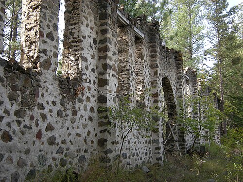
After investing $1 million in infrastructure, The British Columbia Portland Cement Company plant opened about 3 kilometres (2 mi) northeast in 1913 but closed weeks later.[29] The ruins are part of the Rainbow Lake Castle Resort.[30]
In 1910, water mains were installed. The providers of town electricity were Princeton Coal and Land 1911–1914 and then the copper mining company from 1915, running a line from the defunct cement plant. In 1917, West Kootenay Power agreed to extend a line from Bonnington Falls dam. In 1922, the Princeton Light and Power Co became the distributor.[31]
Although forestry and mining have been the dominant industries since that time,[32] tourism and agriculture developed in the latter half of the century,[33] and pharmaceutical cannabis production emerged around 2020.[34]
Princeton is part of School District 58 Nicola-Similkameen, and has two elementary schools (John Allison for grades K–3 and Vermilion Forks for grades 4–7), and Princeton Secondary School (for grades 8–12), which includes The Bridge (for adult learners who have not completed high school).[35]
Interior Health provides level 1 health care at the Princeton General Hospital. The 6-bed acute care unit is complemented by a 36-bed extended care unit (Ridgewood Lodge).[33]
The town also has a diabetes clinic, a mental health drop-in centre, and various counseling services to address needs such as balanced nutrition and substance abuse.[36]

The Great Northern Railway (GN) owned the Vancouver, Victoria and Eastern Railway (VV&E). In November 1909, the northwestward advance of the VV&E rail head crossed the falsework of the Similkameen rail bridge and entered Princeton.[37] In July 1911, tracklaying continued westward through the tunnel excavated beneath Bromley Ridge.[38]
The Canadian Pacific Railway (CP) owned the Kettle Valley Railway (KV). In April 1915, the westward extension of the KV rail head crossed the Tulameen River and joined the GN track in Princeton.[39]
In October 1920, the CP branch from Princeton to Copper Mountain was completed.[40]

Prior to 1949, the main thoroughfare was via the Merritt area. A bridge over the Tulameen (originally called the North Fork of the Similkameen) was washed out during the 1870s. Subsequently, First Nations provided an informal canoe service, but users demanded a government bridge because the ferry charges were considered exorbitant.[41] In 1885, a two-truss-span bridge was erected.[42]
In May 1900, a ferry was installed across the Similkameen to facilitate bridge construction.[43] In March 1901, this Howe truss at the south end of Bridge St was completed,[44] but an ice floe damaged the middle pier and shattered the southern abutment of the Tulameen bridge.[45] At the time, C.O. French had been operating an aerial ferry over the Similkameen about 3 kilometres (2 mi) upstream.[46] That August, the Tulameen bridge was completely rebuilt as a Howe truss.[47]

1918年に、シミリカミーン橋の横に2径間のハウ・トラス橋が建設され[ 48 ]、旧橋は翌年に解体された[ 49 ] 。
1930年代に建設された、代替となる片側一車線の木造トゥラミーン橋は、ブラウン橋として知られている。2018年には、セミトレーラーが橋に構造的な損傷を与えたが、これは数多くの同様の事故の1つである。[ 50 ]
1948年にシミリカミーン橋に取って代わった鋼鉄製のトラスは、2003年にコンクリート製の橋桁に置き換えられた。[ 28 ] [ 51 ]
1964年に、トゥラミーン川に架かる現在の鋼鉄製の高速道路橋が開通した。[ 52 ] [ 53 ]
2009年、受賞歴のある「夢の橋」が1915年のKV橋の下部構造の上に建設された。[ 54 ]

道路網の発達は、1873年、[ 55 ] 1925年、[ 56 ] 1937年、[ 57 ]および1956年の地図に示されている。 [ 58 ]
1899年までに、スペンスズ・ブリッジからの駅馬車の旅は3日半かかるようになった。[ 31 ] 2人の運行業者がこのルートで週1回の駅馬車を提供していた。[ 59 ]
1901年にプリンストン-ヘドリー-ケレメオス道路が建設され、最初の区間はオールドヘドリー道路であった。[ 60 ]
1920年にメリット-プリンストン間の自動車駅馬車が運行を開始した。[ 61 ] 1928年にはメリットへの道路が高速道路に格上げされた。[ 62 ]南端を形成していたコールモント道路は、アリソン湖を経由する現在の区間に置き換えられた。[ 63 ]
南岸沿いの廃止された VV&E の線路跡地に高速道路を敷設し、オールド ヘドリー ロードのプリンストン-ステムワインダー区間を置き換える形で、[ 64 ] 1947 年 5 月に南東方向の隣接区間の舗装工事が入札された。[ 65 ] 1949 年 11 月にホープ-プリンストン高速道路が開通した。[ 66 ]
1960年までに、グレイハウンドはメリット-プリンストン路線を廃止した。1961年9月、代替運行会社も運行を中止した。[ 67 ]
In June 2018, Greyhound abandoned the Hope–Penticton route, which included Princeton.[68] The summer bus service between Kaslo and Vancouver, instituted by a regional operator in June 2019, routed through Princeton.[69] By 2023, the twice weekly service, which stopped in Princeton, had become year round.[70]
The South Okanagan-Similkameen Transit System operates a three times weekly schedule along the Princeton-Penticton corridor, with connections to other BC Transit services at Penticton.[71]
Princeton Aerodrome is not served by any scheduled carriers and has extremely limited facilities. It was formerly home to an Air Cadet Gliding Program. The nearest airport with regional scheduled passenger services is Penticton Regional Airport, and with both regional and international destinations is Kelowna International Airport.
In 1987, Burt Reynolds starred in the film Malone, which was filmed mainly in neighbouring Hedley, but included key scenes in downtown Princeton and the surrounding area. Also partly shot in the area was Sean Penn's 2001 film The Pledge, starring Jack Nicholson, which was also filmed in Lytton and Lillooet.
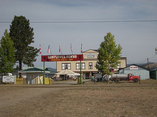
In 2016, the Similkameen News Leader ceased publication.[83]
The 2021 flood submerged half the town after the rivers overflowed their banks and dikes. Water levels were 150 centimetres (59 in) higher than the 1995 flood.[84]
In the early 2020s, the downtown was again revitalized with the placement of bronze wildlife statues, sidewalk upgrades,[85] and visitor centre and RV campground enhancements, partially financed by a $750,000 federal government grant.[86]
In 2023, 20 new temporary homes opened for seniors displaced by the 2021 flood.[98]
Community services are typical for a town of this size.[99]
In addition to camping, fishing, hunting, and golf, popular activities include:
Annual events include The Princeton Pro Rodeo, Family Day, and Canada Day celebrations.
Important facilities are the Centennial Pool, 700-seat hockey arena, curling rink, and 14 local parks.[33]
In the 2021 Census of Population conducted by Statistics Canada, Princeton had a population of 2,894 living in 1,377 of its 1,521 total private dwellings, a change of 2.3% from its 2016 population of 2,828. With a land area of 59.28 km2 (22.89 sq mi), it had a population density of 48.8/km2 (126.4/sq mi) in 2021.[103]
According to the 2021 census, religious groups in Princeton included:[104]
Princeton has a continental climate (KöppenDfb) with semi-arid influences. It is located just east of the Cascade mountains, giving the town a rain shadow effect whereby the community receives very little precipitation relative to areas on the windward side of the Cascade mountains. Princeton is one of the sunniest places in British Columbia with 2,088 hours of sunshine annually. The 323 days per year with measurable sunshine, defined by having a minimum of 6 minutes of sunshine in a day,[115] is the most in the province, and one of the highest in Canada. The 29.4 days with measurable sunshine in March is the highest in the country.
^a. Extreme high and low temperatures were recorded at Princeton from July 1936 to May 1942 and at Princeton Aerodrome from November 1936 to present.
 ウィキボヤージュによるプリンストン旅行ガイド