
Loading article…

割譲および征服された州は、 1805年から1834年までイギリス東インド会社によって統治された北インドの地域を構成していました。[ 1 ]現在のインドでは、アワドのラクナウとファイザーバード地区を除くウッタル・プラデーシュ州のほぼすべての地域に相当します。さらに、デリーの領土、1816年以降はクマウン地区と現在のウッタラカンド州のガルワール地区の大部分[ a ]も含まれていました。[ 1 ] 1836年にこの地域は北西州(副総督の下)となり、1904年にはアグラ・オウド連合州内のアグラ州となりました。[ 1 ]
At the start of the 19th century, only the Benares division and the fort of Allahabad in present-day Uttar Pradesh were under British rule.[1] In 1801, the Nawab of Awadh, Saadat Ali, ceded some territory to the British in return for protection against a threat of attack from the north-west by Zaman Shah Durrani, the grandson of Ahmad Shah Durrani.[1] The territory included the Gorakhpur and Rohilkhand divisions; the districts of Allahabad, Fatehpur, Cawnpore, Etawah, Mainpuri, Etah; the southern part of Mirzapur; and the terai parganas of Kumaun, and came to be known as the Ceded Provinces.[1] A year later the Nawab of Farrukhabad ceded Farrukhabad district to the British.[1]
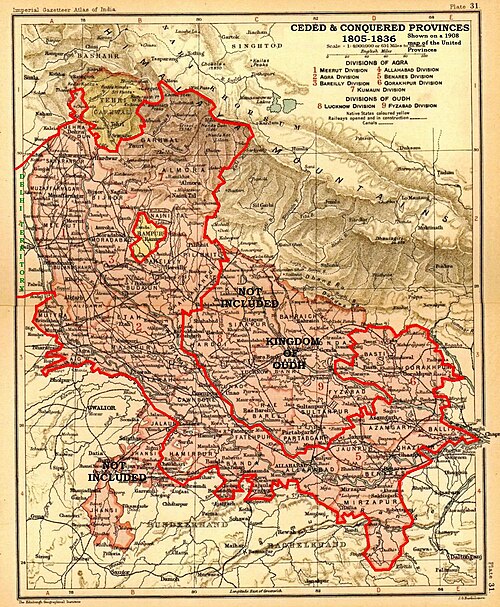
With the outbreak the Second Anglo-Maratha War, General Lake, took the Meerut division (including Aligarh, after the Battle of Ally Ghur), and soon, the rest of the Agra division (including Agra city), and the districts around Delhi.[1] In addition, most of the trans-Jamuna districts of Banda and Hamirpur were added, as well as a small area in Jalaun district.[1]
In 1816, under the Treaty of Sugauli signed at the conclusion of the Anglo-Nepalese War (1814–1816), the Kumaon division and Dehradun district of present-day Uttarakhand state were annexed as well.[1]
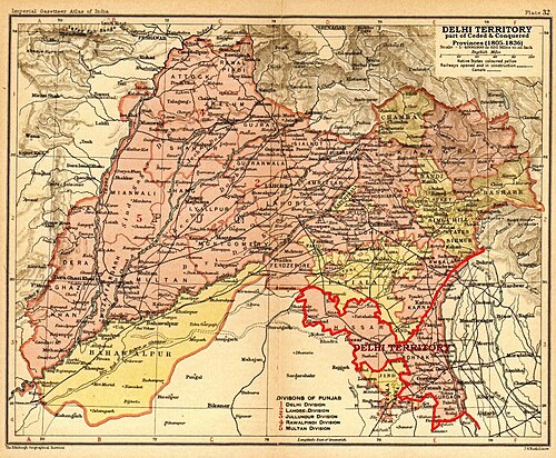
割譲および征服された州は、総督評議会の統治下にあるイギリス領インドのベンガル管区の一部でした。[ 1 ]新たに獲得した領土が管区の首都カルカッタ から遠く離れていたため、行政上の問題が生じました。[ 2 ]これに対し、いくつかの暫定的な措置が試みられましたが、最適とは言えませんでした。最終的に、1831年に、これらの州のために独立した歳入委員会と、独立したサドル・ディワニおよびニザマト・アダラット(最高民事および刑事裁判所)が設立されました。[ 2 ] 1833年、イギリス議会の法律である1833年インド統治法(3 & 4 Will. 4 . c. 85)により、ベンガル管区の分割、割譲および征服された州のアグラ新管区への昇格、および後者の新総督の任命が同時に公布されました。[ 2 ] しかし、この計画は実行されず、1835年に別の議会法であるインド(北西州)法1835(5 & 6 Will. 4 . c. 52)により、この地域は北西州と改名され、今度は副総督によって統治されることになり、初代副総督であるチャールズ・メトカーフ卿が1836年に任命された。[ 2 ]