
Loading article…
コルン川(/ k oʊ n /または/ k oʊ l n /)は、イングランドのエセックス州を流れ、コルチェスターを通過する小さな川です。他の川の支流ではなく、ブライトリングシー付近で海に注ぐ河口を持っています。川の名前はケルト語に由来し、「岩」を意味する「cal」と「川」を意味する「 afon 」の語根を組み合わせたもので、「石の多い川」という意味になります。しかし、別の説では、川の名前は元々 「コロニアの水路」を意味する Colonia Fluvius であったとされています。 [ 1 ]これは、ローマ時代のコルチェスターの地位を指しています。イギリスには、同じ名前の川が他に 2 つあります。
コルン川の支流のうち2つは、エセックス州のスタンボーン・グリーン村とバードブルック村の近くを源流とし、グレート・イェルダムで合流する。一方、より長い支流はコーニッシュ・ホール・エンドの北西を源流とし、グレート・イェルダムのすぐ南で他の源流に合流する。その後、川は南東に流れ、シブル・ヘディンガム、ハルステッド、アールズ・コルン、コルン・エンゲイン、ホワイト・コルン、チャペル、フォード・ストリートを経て、コルチェスターに至る。
グレート・イェルダムとウェイクス・コルンの間を流れる川は、かつてヘイヴァーヒルから運行されていたコルン・バレー・アンド・ハルステッド鉄道のルートに沿っている。この鉄道は1961年に旅客営業を終了した。キャッスル・ヘディンガム周辺の1マイル(約1.6キロ)の区間は、コルン・バレー鉄道として保存されている。

The Colne Valley has a flood plain approximately 300 metres in width by the time it enters Colchester. This area is used as pasture because the river at this stage has no safeguards against it rising the two feet it needs to burst its banks, although it is split between two pasture areas in Spring Lane, Old Lexden. Somewhat to the south of Colchester North railway station, the river passes under a bridge and into a concrete-lined area that was used as an open-air bathing facility until the 1970s, and is now used by canoeists.
It then meanders under a road bridge at the bottom of North Hill, and tumbles down a weir used for discharge control at Middlemill, the site of a now-demolished mill. It forms the border of Colchester's Castle Park and the cricket ground, and footbridges cross it to provide access from the town centre to residential areas on the north side of the flood plain, which occasionally floods should the river rise too much. The river encircles one side of a small lake, and then turns south-east, and then south, before falling over a large weir and becoming tidal.
Beyond this point, the river shows significant mud banks at low tide, and flows through the Hythe, past the University of Essex campus, and then through the village of Rowhedge, where it is attributed to by the Roman River. It continues past the town of Wivenhoe and the Colne Barrier[2] and down to Brightlingsea. Downstream from the barrier, the Colne is marked by navigation buoys.


The banks of the Colne frequently incorporate pillboxes dating from the Second World War, particularly close to navigable crossings.
From Castle Park to Wivenhoe Railway Station, National Cycle Network Route 51 roughly follows the course of the Colne. This is a mixture of tarmac-surfaced shared-use paths, a short tarmac/gravel-surfaced area and, once out of the urban area of Colchester, a hard dirt path on the north levee of the river that passes the Hythe and the university all the way to Wivenhoe.
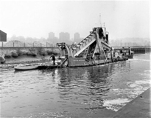
The Hythe area of Colchester, through which the Colne flows, was, from Roman times, a small port that supplied the town. However, the river is no longer deep enough to support ships large enough to make this viable, and water trade is now non-existent. Victorian-era plans to dredge the river once more ultimately failed.
規制変更後、コルン川は英国の他の多くの水路と同様に下水処理場によって汚染されました。このため、川で泳ぐことを好む周辺地域住民の間では、中程度の騒動が起きており、野生生物への影響も懸念されています。[ 3 ]