
Loading article…
| マリリン | |
|---|---|
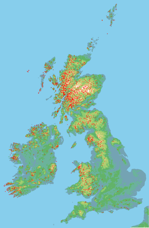 イギリス諸島のマリリン(赤い点) | |
| 最高点 | |
| 標高 | 要件なし |
| プロミネンス | 150メートル(492フィート)以上 |
| 地理 | |
| 位置 | |
これは、イギリス、アイルランド、および周辺の島々と海の岩礁にあるマリリンの丘と山の一覧です。マリリンは、高さやその他の価値(たとえば、マンローで使用されている 地形的孤立性)に関係なく、突出部が150メートル(492フィート)以上の山頂として定義されています。 [1] したがって、マリリンは、高さが600メートル(2,000フィート)を超える山、または比較的小さな丘の場合があります。[2] 2023年7月現在、2,010のマリリンが記録されています。[1][update]
意味
マリリンの分類は、アラン・ドーソンが1992年に著した『The Relative Hills of Britain』で考案された。[3]マリリンという名前は、標高3,000フィート(914.4メートル)を超えるスコットランドの山々のマンロー分類と対照的な語呂合わせでドーソンが作ったものだが、マンロー分類には明確な突出度の閾値がなく、マリリン・モンローと同音異義語となっている。[4] マリリンのリストはクレム・クレメンツによってアイルランドにまで拡張された。[5]
マリリンは、 P600、[6] HuMP 、TuMPなど、プロミネンスのみに依存するその後のイギリス諸島の分類の最初のものでした。[7]地形上のプロミネンスは地形上の標高 よりも推定が難しく、山頂の周りの等高線をそれぞれ調査する必要があるため、プロミネンスを使用するリストは改訂される可能性があります。[8] [9]
ベン・ネビス山、カラントゥーヒル山、スカフェル・パイク山、スノードン山など、島で最も大きな山の多くはマリリン山ですが、ケアン・ゴーム山、多くのマンロー山、ボウフェル山、ラングデール・パイク山、カーネッド・ダフィズ山などの有名な丘陵など、他の多くの大きな山頂は、周囲の地形に比べて高さが十分ではない(つまり、より高い「親山」がある)ためマリリン山ではありません。マリリン山のすべてが通常の意味での丘陵というわけではありません。クロウバラ山(242メートルまたは794フィート)は町の中にあり、ヨークシャー・ウォルズの最高地点であるビショップ・ウィルトン・ウォルド(248メートルまたは814フィート)はA166道路沿いにあります。もう一方の極端な例は、イギリス諸島で最も高い海食柱であるスタック・リー(172メートルまたは564フィート)とスタック・アン・アルミン(196メートルまたは643フィート)で、スコットランド本土から西に100マイル(160キロメートル)離れたセント・キルダ諸島にあります。 [ 10 ] [ 11 ] [12]
2023年7月現在[update]、イギリス諸島には2,010のマリリンがあり、スコットランドには1,218のマリリンがあり、スコットランドの282のマンローのうち202が含まれています。マリリンが目立つマンローはリアルマンローと呼ばれることもあります。 [1] さらにアイルランドには454のマリリン、イングランドには174、ウェールズには159、マン島には5つのマリリンがありました。[1] 2014年10月13日、ロブ・ウッドオールとエディ・ディールトリーはイギリスの1,557のマリリンすべてを登頂した最初の人々になりました。[13] [14] 2022年現在[update]、11人のマリリニストが「記録時点でマリリンとして分類されていた[イギリスの]すべての丘」を登頂しており[15]、2019年12月現在、275人が600を超えるマリリンを登頂してマリリンの殿堂[update]入りを果たしている。[16]
カバレッジ


2020年4月現在[update]、2,010人のイギリス諸島マリリンのリストには以下が含まれています。
- スコットランドの 282 のマンロー山のうち 202 はマリリン山 (リアル マンロー山と呼ばれることが多い) であり、227 のマンロー山頂のうちマリリン山は 1 つもない(つまり、マンロー山頂はマリリンではない)。
- スコットランドのコルベット族全 222 名、スコットランドのグラハム族全 219 名、およびスコットランドのニュードナルド族118 名のうち 31 名。
- 2,754のブリテン諸島シムズのうち872 ; [a]
- イングランド、ウェールズ、アイルランドのヒューイット家525人のうち203人
- 湖水地方のバーケット541棟のうち43棟(うちウェインライト39棟)
- アイルランドの407人の市長のうち163人;
- イギリス諸島にある120 のP600 (「主要」)山すべて。
- イングランド、ウェールズ、アイルランドの 34 ファースのうち 14ファース。
高さと目立つ度合いによって
このリストは、2018 年 10 月に英国およびアイルランドの丘陵データベース(DoBIH)からダウンロードされたもので、DoBIH がマリリン (M) としてマークした山頂です。 [b] トポロジカル プロミネンスの測定は複雑なため、これらの表は時間の経過とともに改訂される可能性があり、DoBIH データ全体を再ダウンロードしない限り、修正または更新しないでください。表は、英国諸島全体または地域ごとに高さとプロミネンスによるランキングを示すように構成されています。
アップデート
表がダウンロードされて以来、認められたマリリンのリストには以下の変更が加えられました: [18]
- 追加:ライノグ・ファック、ウェールズ、2021年8月(標高711.67メートル(2,334.9フィート)、突出部151メートル(495フィート))[19]
- 削除:ケント州シェリトンヒル(標高187.7メートル (616フィート)、突出部149.7メートル (491フィート)) [20]
- 削除: アイラ島、ジュルベイン (標高317.4メートル (1,041フィート)、突出部148.9メートル (489フィート)) [21]
テーブル
地域ごとの最高峰。
Bibliography
- Alan Dawson (1997). The Hewitts and Marilyns of Wales. TACit Press. ISBN 0-9522680-6-X.
- Clem Clements (1998). The Hewitts and Marilyns of Ireland. TACit Press. ISBN 0-9522680-8-6.
- Alan Dawson (1997). The Hewitts and Marilyns of England. TACit Press. ISBN 0-9522680-7-8.
- Alan Dawson (1992). The Relative Hills of Britain. Cicerone Press. ISBN 978-1852840686.
DoBIH codes
The DoBIH uses the following codes for the various classifications of mountains and hills in the British Isles, which many of the above peaks also fall into:[22][23]
- Ma Marilyn
- Hu HuMP
- Sim Simm
- 5 Dodd
- M Munro
- MT Munro Top
- F Furth
- C Corbett
- G Graham
- D Donald
- DT Donald Top
- Hew Hewitt
- N Nuttall
- Dew Dewey
- DDew Donald Dewey
- HF Highland Five
- 4 400-499m Tump
- 3 300-399m Tump (GB)
- 2 200-299m Tump (GB)
- 1 100-199m Tump (GB)
- 0 0-99m Tump (GB)
- W Wainwright
- WO Wainwright Outlying Fell
- B Birkett
- Sy Synge
- Fel Fellranger
- CoH County Top – Historic (pre-1974)
- CoA County Top – Administrative (1974 to mid-1990s)
- CoU County Top – Current County or Unitary Authority
- CoL County Top – Current London Borough
- SIB Significant Island of Britain
- Dil Dillon
- A Arderin
- VL Vandeleur-Lynam
- MDew Myrddyn Dewey
- O Other list (which includes):
- Bin Binnion
- Bg Bridge
- BL Buxton & Lewis
- Ca Carn
- CT Corbett Top
- GT Graham Top
- Mur Murdo
- P500 P500
- P600 P600
- Un unclassified
prefixes:
- s sub
- x deleted
suffixes:
= twin
See also

Wikimedia Commons has media related to Marilyns.
- Lists of mountains and hills in the British Isles
- List of mountains of the British Isles by height
- Lists of mountains and hills in the British Isles
- Lists of mountains in Ireland
- List of Munro mountains
- List of Murdo mountains
- List of Furth mountains in the British Isles
- List of P600 mountains in the British Isles
Notes
- ^ It does not include the two peaks whose prominence rounds up to 150 m
- ^ The Database of British and Irish Hills ("DoBIH") is the most referenced database for the classification of peaks in the British Isles,[7] and the DoBIH is licensed under a "Creative Commons Attribution 3.0 Unported License".[17]
- ^ Sorrel Hill height is 599.5 m, and thus below the 600.0 m threshold for a Simm
References
- ^ a b c d "The Marilyns". HillBaggingUK. 2023. Archived from the original on 10 July 2023.
A Marilyn is "a hill of any height with a minimum drop of 150 metres [492 feet] or more on all sides". So it is a hill which is relatively high compared to its surroundings. [...] The Marilyns are so–called by the list's compiler, Alan Dawson, after the more famous mountain list - the Munros. Alan's original list is of mountains and hills in Scotland, England, Wales and the Isle of Man. The same concept was applied to Ireland by E D "Clem" Clements. Anyone who has climbed 600 British Marilyns is eligible for entry into the Marilyn Hall of Fame.
- ^ Alan Dawson. "Marilyns". The Relative Hills of Britain.
A Marilyn is a hill of any height with a drop of 150 metres or more on all sides. In other words, a relatively high hill. The Marilyns in Britain and the Isle of Man are listed in a book called The Relative Hills of Britain (RHB) by Alan Dawson, published by Cicerone Press in April 1992. Details of subsequent changes have been published in a series of updates.
- ^ Dawson, Alan (1992). The Relative Hills of Britain. Milnthorpe, Cumbria: Cicerone Press. ISBN 1-85284-068-4. Archived from the original on 21 September 2010.
- ^ Dawson, Alan (April 2006). "Update to The Relative Hills of Britain". The Relative Hills of Britain. Retrieved 9 May 2018.
- ^ Clements, E.D. 'Clem' (1998). The Hewitts and Marilyns of Ireland. Cambuskenneth, Stirling: TACit Press. ISBN 0-9522680-8-6.
- ^ Alan Dawson; Rob Woodall; Jonathan de Ferranti (2006). "THE BRITISH ISLES COMBINED LIST FOR THE UNITED KINGDOM AND REPUBLIC OF IRELAND".
By lowering the cutoff to 600 metres (in order to be consistent with upcoming lists for Europe), we now reach a total of 119 mountains, including 93 for Great Britain, 1 on Man, and 25 in Ireland.
- ^ a b Jackson, Mark. "More Relative Hills of Britain" (PDF). Relative Hills of Britain. Archived from the original (PDF) on 12 October 2013. Retrieved 9 September 2011.
- ^ Alan Dawson (March 2022). "Marilyn timeline". The Relative Hills of Britain. Retrieved 11 September 2023.
The Marilyns in Britain and the Isle of Man were first listed in the book The Relative Hills of Britain (RHB) by Alan Dawson, published by Cicerone Press in April 1992. At that time there were 1542 Marilyns, which had increased to 1557 by the end of July 2018 [2,011 including Ireland]. Details of subsequent changes have been published in a series of update sheets from 1995 onward. A summary of the main changes since 1992 are set out below.
- ^ Alan Dawson (March 2016). "Surveying and mapping standards". The Relative Hills of Britain (rhb.org.uk).
- ^ Alan Dawson (1992). "Chapter 1: Mountains, Munros and Marilyns". The Relative Hills of Britain (rhb.org.uk).
- ^ Alan Dawson (1992). "Chapter 2: The Challenge of the Marilyns". The Relative Hills of Britain (rhb.org.uk).
- ^ McKim, Claire (2 November 2015). "St Kilda: Britain's most remote location". The Scotsman.
- ^ McKenzie, Steven (2014). "Marilyn bagger from Peterborough scratches 22 year itch". BBC News. Retrieved 15 October 2014.
- ^ "Woodall and Dealtry bag Marilyns". 2014. Archived from the original on 21 October 2014. Retrieved 21 October 2014.
- ^ Chris Watson (July 2018). "Marilynists". The Relative Hills of Britain (rhb.org.uk).
Current number of Marilyns: 1556. Current number of Marilynists: 11. Last updated: 22 March 2022
- ^ Chris Watson (December 2019). "Marilyn Hall of Fame: 31 December 2019". The Relative Hills of Britain (rhb.org.uk).
- ^ "Copyright". Database of British and Irish Hills. 3 August 2018.
We place no restrictions on use of the data by third parties and encourage authors of other websites and applications to do so. We just ask users to observe the terms of the Creative Commons license
- ^ “RHB: Marilyns”. www.rhb.org.uk . 2023年7月10日閲覧。
- ^ 「ライノグ・ファッハ」. www.hill-bagging.co.uk。ヒルバギング。2023 年7 月 10 日に取得。
- ^ 「Cheriton Hill」www.hill-bagging.co.uk . Hill Bagging . 2023年7月10日閲覧。
- ^ “Giur-bheinn”. www.hill-bagging.co.uk . Hill Bagging . 2023年7月10日閲覧。
- ^ 「分類」。英国およびアイルランドの丘陵データベース。2018年8月3日。
- ^ 「英国およびアイルランドの丘陵データベース(DoBIH)のオンライン版へようこそ」HillBagging 。 2018年11月8日閲覧。
外部リンク
ウィキメディア・コモンズには
、 マリリン(カテゴリ)に関連するメディアがあります。
、 マリリン(カテゴリ)に関連するメディアがあります。
- 英国およびアイルランドの山々のデータベース(DoBIH)は、英国諸島の山々に関する最大のデータベースです。
- Hill Bagging UK & Ireland、DoBIHの検索可能なインターフェース
- MountainViews: アイルランドの山岳ウェブサイト、アイルランド共和国および北部の DoBIH
- MountainViews: アイルランドのオンライン山岳データベース、MountainViewsの検索可能なデータベース
- 英国の相対的な丘陵、山と丘の分類に特化したウェブサイト
- すべてのマリリンを表示する Google Earth .kmz ファイル