
Loading article…
Trebarwith Strand (Cornish: Trebervedh Sian; locally sometimes shortened to The Strand) is a section of coastline located near the coastal settlement of Trebarwith on the north coast of Cornwall, England, UK, 2+1⁄2 miles (4.0 km) south of Tintagel. It has 800m of sandy beach contained by cliffs in which natural caves are found. The beach can only be accessed at low tide. The strand was once used to land ships to export slate from the nearby quarries while sand from the beach was used for agricultural purposes. The view from the beach is dominated by rocks 300m offshore known as Gull Rock or Otterham Rocks.
The name Trebarwith was first associated with the village on the higher ground to the south of the valley which is the most southerly part of Tintagel parish. Land at Trebarwith is first mentioned in records of 1284 and was held from 1329 until the early 16th century by the Lercedekne family.[1] Trebarwith Farm is a Grade II listed building.[2] The road along the valley from Penpethy to the Strand is known as the Sanding Road and was originally built c. 1825 to allow the collection of sand.[3] The local soil is acidic and so sand and lime were fed into it. The sand was loaded into sacks and carried up the hill by donkeys and ponies. A large pool that can be accessed at low tide is known as the horses' pool as this is where the animals cooled off on hot days.[4]

Trebarwith Strand was central to Tintagel's slate industry. Quarrying has taken place here since the fifteenth century and around eight disused quarries scar the coast between the beach and Tintagel Castle. There are also quarries lining the Sanding Road as it climbs up from the beach. Ships brought coal to Port William at the southern end of the beach where cranes and derricks would winch slate down the cliff to be taken away for export.
At Lill Cove a small water-powered copper mine led up from the beach to the cliffs above Trebarwith, though the tunnels at the beach end have now been blocked by rock falls.[5]
A wide "road" has been cut through the rocks at the top of the beach to allow access for the donkeys and ponies bringing sand to the settlements inland.
19世紀、ビーチへのアクセスポイント近くにホテルが建てられました。現在は土産物店と貸別荘として利用されています。1970年代のある時期に、ホテルの厩舎棟がパブに改装され、現在はポート・ウィリアムという名前で営業しています。
1886年10月、帆船サラ・アンダーソン号がガルロック沖で難破し、乗船者全員が死亡した。[ 6 ]
2015年2月、ある男性がビーチで妹の遺灰を撒いている最中に海に流された。[ 7 ]

潮が最も引くと、海は300ヤード(270メートル)後退し、幅1/2マイル(800メートル)を超える砂浜が現れます。崖のふもとの潮だまりは、小魚やカニが潮が満ちるまで隠れるのに最適な場所であり、イシマキガイ、フジツボ、カサガイ、ムール貝などの小型軟体動物が岩に群生しています。
トレバーウィス・ストランドでは、小さな無名の小川が海に流れ込んでいる。その約1マイル上流には、水車で動く製粉所があった。現在はその建物は「ミル・ハウス・イン」という名のパブになっている。
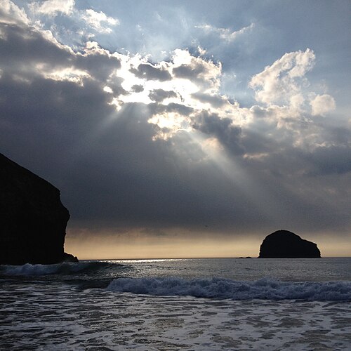
大西洋から頻繁に押し寄せる強いうねりはサーフィンに最適で、砂浜は子供たちにとって理想的ですが、潮の満ち引きはビーチに大きな影響を与えます。潮が満ちてくると、砂浜は押し寄せる海水に急速に浸食され、崖の麓の岩だけが残るビーチになります。RNLIは勤務時間中(9時~17時)にライフガードを配置しています。不用心な観光客は簡単に水位の上昇によって孤立してしまう可能性があり[ 8 ]、毎年多くの人が救助されています[ 7 ] 。
ビーチへの車両アクセスは、B3263ティンタジェルからキャメルフォードへの道路から狭い谷を下るサンディング ロードと呼ばれる行き止まりの小道を通る。ティンタジェルからは、トレクノウ村を通る近道があり、そこからサンディング ロードに合流する。隣接する使われなくなったスレート採石場の 1 つは、クドヴァと呼ばれるグランピング サイトになっている。[ 9 ]
トレバーウィス・ストランドは、南西海岸遊歩道沿いの北側と南側の両方からハイカーがアクセスできます。アクセス用地を通る遊歩道には、1937年まで稼働していた崖の採石場の掘削孔やその他の遺構があります。[ 10 ]
1974年の映画『マラキの入り江、あるいは海藻の子供たち』は、アンソニー・トロロープの物語を原作とし、ヘンリー・ハーバートが監督を務め、主にトレバーウィスで撮影された。この映画では、ドナルド・プレザンスがマラキ役を演じた。 [ 11 ]
トレバーウィス・ストランドは、1996年のシェイクスピア劇『十二夜』で、イリュリアの海岸の代わりとして使われた。ガル・ロックは、1997年の映画『オスカーとルシンダ』と2000年の映画『セイビング・グレイス』の背景として用いられた。
北緯50度38分41秒、西経4度45分42秒/北緯50.6447度、西経4.7618度/北緯50.6447度、西経-4.7618度