
Loading article…


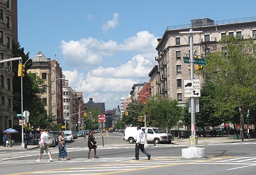
セント・ニコラス・アベニューは、ニューヨーク市マンハッタン区の111丁目から193丁目までの数ブロックを南北に斜めに走る主要道路です。セント・ニコラス・アベニューは、ハーレムのウエストサイドとセントラルハーレムの境界となっています。この道路は、1811年のコミッショナーズ・プランのグリッドパターンよりもはるかに古いルートをたどり、ハーレム、ハミルトン・ハイツ、ワシントン・ハイツの各地区を通過します。この道路は、17世紀にオランダのニューアムステルダム入植地とイギリスのニューイングランド植民地を結ぶ重要な道路となった、古いインディアンの道のルートをたどっていると考えられています。植民地時代以降、ボストン・ポスト・ロードの西端となりました。この道路は、南北戦争終結後の急速な都市拡大期にハーレムで長屋住宅が建設された際に、通りとなりました。
169丁目以北では、セント・ニコラス・アベニューは、1ブロック西(174丁目以北)にワズワース・アベニュー、 1ブロック東にオーデュボン・アベニューがある通りのグリッドに沿っています。178丁目と179丁目でトランス・マンハッタン高速道路を横断します。167丁目でセント・ニコラス・アベニューとブロードウェイが交差する地点はミッチェル・スクエア・パークになっています。169丁目以南では、セント・ニコラス・アベニューはマンハッタンの通りのグリッドの大部分に対して斜めに走り、 162丁目でアムステルダム・アベニューを横断し、西148丁目まで逆方向に続きます。148丁目以南では、セント・ニコラス・アベニューは再びグリッドに沿って走り、1ブロック西にコンベント・アベニュー、東にエッジコム・アベニューがあり、124丁目まで続きます。 124丁目より南では、セント・ニコラス・アベニューは急な斜めの線を描き、121丁目でフレデリック・ダグラス・ブールバードと、116丁目でアダム・クレイトン・パウエル・ジュニア・ブールバードと交差し、セントラルパークのすぐ北にあるレノックス・アベニューで終点となる。17世紀にイースタン・ポスト・ロードの一部として建設されたことが、1811年の委員会計画で提案されたグリッド状の街路パターンに合致しない理由である。
The IND Eighth Avenue Line (A,B,C, andDtrains) runs under St. Nicholas Avenue north of 121st Street as far as 168th Street, and is sometimes referred to as the St. Nicholas Avenue Line. The IRT Broadway-Seventh Avenue Line (1train) also has stations on the avenue at 181st & 191st Streets.
Bus service is provided by the following:
The street is claimed to follow an old Wecquaesgeek trail. From early colonial days through the 19th century, it was known as Harlem Lane.[1] Travelers used it for going between New York and northern areas such as Spuyten Duyvil and Kingsbridge.[2] In 2011, the location of one of Old Croton Aqueduct's ventilating towers was discovered on the east side of the avenue.[3]
St. Nicholas Avenue is named after Saint Nicholas of Myra, patron saint of New Amsterdam since Dutch times.[4]
On September 30, 1956, an American pilot named Thomas Fitzpatrick landed a stolen plane near 191st Street in front of a New York City bar where earlier he had been drinking and made an intoxicated barroom bet that he could travel from New Jersey to New York City in 15 minutes.[5][6]
In 2000, Mayor Rudolph Giuliani signed a bill adding the name "Juan Pablo Duarte Boulevard" to St. Nicholas Avenue for the stretch from Amsterdam Avenue and West 162nd Street to the intersection of West 193rd Street and Fort George Hill. The added name was in honor of Juan Pablo Duarte, one of the founding fathers of the Dominican Republic.[7]
 ウィキメディア・コモンズにある、セント・ニコラス・アベニュー(マンハッタン)に関連するメディア
北緯40度49分39.67秒、西経73度56分33.56秒/北緯40.8276861度、西経73.9426556度/北緯40.8276861度、西経73.9426556度