
Loading article…
サンアントニオ、正式にはサンアントニオ市(ワライ:ブングト・サン・サン・アントニオ;セブアノ語:ルンソッド・サ・サン・アントニオ;タガログ語:バヤン・ン・サン・アントニオ)は、フィリピン北部サマール州の自治体です。 2024 年の国勢調査によると、人口は 8,882 人です。[ 4 ]
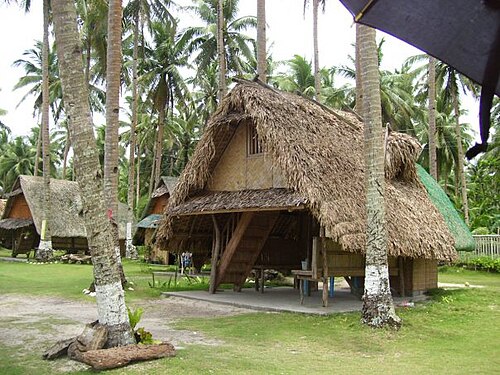
その領土は、サン・ベルナルディーノ海峡の南端、サマール島の西海岸沖にあるダルピリ島と同一である。島の白い砂浜は、東ビサヤ地方の「手つかずの楽園」であり、将来の「一流の観光地」とみなされている。[ 6 ]サン・アントニオはまた、過去にボホール島やセブ島の入植者が流入したため、北サマールで唯一セブアノ語も話されている自治体であるという点で独特である。地元住民は北サマールの主要言語であり、島内の主要共通語であるワライ語を話す。
19世紀初頭、サマール島本土からの入植者たちは、この島が漁業と鳥猟に理想的な場所であることを発見しました。彼らは魚を捕り鳥を狩るためだけに島にやって来て、少し獲物を捕るとサマール島本土に戻りました。19世紀後半には、ボホール島とセブ島から人々がこの島にやって来て、網を使った漁法、一般に「ラヤ」として知られる漁法を導入しました。この漁法の導入に伴い、「マノグラヤ」という名前が生まれました。これは文字通り「マノ・ンガ・パラグラヤ」、つまり「ラヤを使う漁師たち」という意味です。
新たな入植者が島にやって来て新しいコミュニティを築くと、彼らはその島を「スゴド・スゴド」と呼んだ。これはセブアノ語で「始める」という意味である。その後、島のナイフのような形にちなんで「マタビア」と改名された。なぜそのように改名されたのかは、今では誰も知らない。民話にも歴史的資料にも、ダルピリ島への改名の経緯や理由は明らかにされていない。
1904年、サンアントニオはサマール州の自治体として設立されました。その名前は守護聖人であるパドヴァの聖アントニオにちなんで付けられました。1965年のサマール州分割住民投票の後、北サマール州の一部となりました。[ 7 ]

ダルピリ島はフィリピン諸島の東中央部に位置する。北と東はサンベルナルディーノ海峡、南はサマール海、西はカプル島に囲まれている。太平洋からは約5海里(9.3km 、5.8マイル)の距離にあり、サンベルナルディーノ海峡としても知られるアカプルコ海峡の入り口付近に位置する。島を囲むように全長28キロメートル(17マイル)の白い砂浜が広がっている。
ダルピリ島は、なだらかな丘陵地帯が広がる面積2,700ヘクタール(6,700エーカー)の島で、大部分はココナッツの木や低木で覆われています。白い砂浜、洞窟、そしてラグバンガン湖があります。
この島は、低く険しい丘陵地帯と小さな低地から構成されている。比較的肥沃な土壌に恵まれており、ほとんどの作物の栽培が可能であるが、現在は主にココナッツ農園として利用されている。
島の最高地点は島の南中央部にあり、海抜35メートル(115フィート)に達する。
この島には明確な乾季や雨季はないが、10月から1月にかけて降雨量が多い。降水量が最も多いのは11月で、5月は比較的乾燥した月である。
サンアントニオは政治的に 10 のバランガイに細分化されています。各バランガイはプロクで構成されており、一部にはシティオがあります。
The town center (poblacion) is divided into three small barangays: Poblacion Ward I, Poblacion Ward II, and Poblacion Ward III.
Barangay San Nicolas, named after its patron Saint Nicolas, is home to picturesque rock formation along the coast. Barangay Rizal is home to a solar spring and cave. Barangay Pilar is the southernmost tip of the island where a fish sanctuary is located. This is the home of palatable seashells and other seafood.
Barangay Burabod's major livelihood is boatbuilding, fishing, copra and dynamite blasting cap manufacturing.
Poverty incidence of San Antonio
Source:Philippine Statistics Authority[13][14][15][16][17][18][19][20]
San Antonio is one of the manufacturing centers of dynamite chemicals like ammonium nitrate, used in the manufacture of blasting caps that are sold in the other provinces of Samar island. It was learned that the island has been tagged by the police as one of the areas in the manufacture of the dynamite blasting caps.
Chief Supt. Abner Cabalquinto, Regional VIII Police Director, disclosed that the police operatives in Northern Samar confiscated 50 bags of ammonium nitrate in the town of San Antonio. However, the suspects were able to escape and alluded arrest by the police.[21]
Because of the prevalence of homemade dynamite, blast fishing is a perennial problem in the region.[22] In 1994, an Italian tourist was killed and another severely injured while diving when a local fisherman dropped his dynamite on top of them. As a result, the Flying Dog Beach Resort, established in the early 1990s, decided to cease its operation.[23][24]
The Dalupiri Ocean Power Plant is a proposed tidal fence generating station across the Dalupiri Passage between the islands of Dalupiri and Samar.[25]


Because of Dalupiri Island's pristine white sand beach, Republic Act No. 9458 declared San Antonio, together with the island towns of Biri, Capul, and San Vicente, as eco-tourism zones in May 2007.[26]
With its coral reefs, Dalupiri island is ideal for scuba diving, snorkeling, sailing, yachting, jet skiing, para-sailing and marine life observation.
A cultural-tourism festival held in the town of San Antonio from the 9th to the 12th of June annually, celebrating the fishing skills of the townfolks. The festival composed of cultural performances, street dance, beauty search and exhibit complemented with “sugod-sugod sa plaza”, a nightly entertainment of music and other performances from leading local performers in the community.
Dalupiri Airport, also known as San Antonio Airport, is an airstrip in San Antonio in the Eastern Visayas region of Philippines. Its construction was approved by the Senate and House of Representatives of the Philippines on August 8, 2004.[27] This airport is still under constructions and not yet operational to the general public, local resident and Island tourist.
San Antonio town proper Seaport the central part of the island premier gateway to the seaport of the town of Victoria. This two seaports are the busiest port connecting the Island and the mainland of Samar, providing main transport system to the island tourist and local resident.
There are also several seaport in the nearby barangay that also the gateway of the Island to the mainland land of Samar, in northern part of the island is the Vinisitahan Seaport and the western coast is the Dalupiri Seaport both to seaport in the town of Allen, Northern Samar and in the southern coast of the Island is the Burabod Seaport to the town of San Isidro, Northern Samar.

島内の様々な場所へ行く主な交通手段はオートバイで、地元ではメーカーに関係なく「ホンダ」と呼ばれています。町の中心部を走ると、地元住民が「パディヤック」と呼ぶ、自転車で牽引する荷車が数多く見られます。
中等学校:
小学校:
{{cite web}}:欠落または空欄|title=(ヘルプ)