
Loading article…
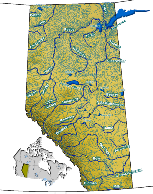
レッドディア川は、カナダのアルバータ州とサスカチュワン州の一部を流れる川です。サウスサスカチュワン川の主要な支流であり、ハドソン湾に注ぐサスカチュワン川/ネルソン川水系の一部です。[ 2 ]
この川の全長は724 km (450 mi)、流域面積は45,100 km 2 (17,400 sq mi)です。平均流量は70 m 3 /s (2,500 cu ft/s)です。[ 1 ]
この川の名前は、クリー語で「ヘラジカの川」を意味するwâwâskêsiw sîpiyという川の先住民の言葉の翻訳に由来しています。[ 3 ] 「アカシカ」はヘラジカの別名で、近縁のユーラシアの種を指していました。
レッドディア川沿いには、サンドレ、レッドディア、ドラムヘラー、エンプレスなどの町があり、ブルックス市やダイナソー州立公園もレッドディア川流域に位置しています。約1万8000年前の氷河洪水により、この流域の一部が浸食され、恐竜やその他の白亜紀の化石を含む景観豊かな悪地のほぼすべて、あるいは大部分が失われたと考えられています。

ジョセフ・ティレルは1883年にここで巨大な石炭層を発見し、その他にも大きな恐竜の骨格を発見した。[ 4 ]
In June 2013, Alberta, Canada, experienced heavy rainfall that triggered catastrophic flooding throughout much of the southern half of the province along the Bow, Elbow, Highwood, Oldman, and Red Deer rivers and tributaries. Twenty-four municipalities declared local states of emergency as water levels rose and numerous communities were placed under evacuation orders.[5] The Royal Canadian Mounted Police stated four people may have drowned near High River.[6] Over 100,000 people in the region were displaced.[7]
The river originates on the eastern slopes of the Canadian Rockies, in the Sawback Range near the Skoki Valley inside Banff National Park, and then flows east through the mountains and foothills region. It turns north-east before Sundre and flows to an artificial reservoir named Gleniffer Lake, created in 1983 by the Dickson Dam and keeps this heading to the city of Red Deer, where it turns east, and then south before Stettler. It flows south with its valley protected by provincial and regional parks such as Tolman Badlands Heritage Rangeland, Dry Island Buffalo Jump Provincial Park, Dry Island Corridor and Midland Provincial Park. At Drumheller it has a south-east direction, and while it flows through Dinosaur Provincial Park it turns east and flows to the Alberta/Saskatchewan border, which it crosses at Empress. It flows for 16 km (9.9 mi) through Saskatchewan before it merges into the South Saskatchewan River.
釣りの対象となる魚には、ウォールアイ、ノーザンパイク、ソーガー、レイクホワイトフィッシュ、イエローパーチ、バーボット、レイクスタージョン、マウンテンホワイトフィッシュ、ゴールデンアイ、ブラウントラウト、ブルトラウト、ニジマス、ブルックトラウト、カットスロートトラウトなどがあります。
その他の魚類には、エメラルドシャイナー、リバーシャイナー、スポットテールシャイナー、フラットヘッドチャブ、ロングノーズデイス、クイルバック(クイルバックカープサッカー)、ロングノーズサッカー、ホワイトサッカー、ショートヘッドレッドホース、シルバーレッドホース、パーチ、スプーンヘッドスカルピン、レイクチャブ、ノーザンパールデイス、ノーザンレッドベリーデイス、ファインスケールデイス、ファットヘッドミノー、ブルックスティックルバックなどが含まれます。


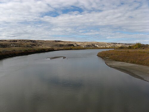
レッドディア川は、レッドディア市とその周辺地域の水源です。パイプラインが川の下を通っており、漏水により飲料水へのアクセスが妨げられています。[ 13 ] 2008年6月の豪雨によるレッドディア川水系の水量増加により、支持土壌が浸食され、ペンビナ・パイプライン社のクレモナ原油パイプラインの一部がレッドディア川の流れに露出しました。レッドディア川の水路の下の破損箇所から上流に約75~125バレル(11,900~19,900リットル、2,600~4,400英ガロン、3,200~5,200米ガロン)の原油が流れ出し、グレニファー貯水池に油膜を残し、6,800kg (15,000ポンド)の油まみれの残骸を残しました。[ 14 ] [ 15 ]修復作業は2011年まで完了しなかった。[ 16 ]
2012年6月初旬の豪雨により、アルバータ州ジャクソンクリーク(北緯51度52分19秒、西経114度36分23秒/北緯51.87194度、西経114.60639度/北緯51.87194度、西経114.60639度)にあるプレーンズ・ミッドストリーム・カナダ社の築46年のパイプラインで、グレニファー湖とディクソンダム付近で同様の、しかしより大規模な漏洩が発生し、レッドディア川に約1,000~3,000バレル(160,000~480,000リットル、35,000~105,000英ガロン、42,000~126,000米ガロン)の軽質サワー原油が流出した。 [ 16 ] [ 19 ]
レッドディアは湿潤大陸性気候(ケッペンのDfb)で、パリサーの三角形の中に位置しているため、半乾燥気候の影響も受けています。レッドディアで記録された最高気温は、1906年7月8日の37.2 ℃(99.0 °F)[ 20 ] 、 1924年7月2日[ 21 ] 、 1937年6月28日と29日[ 22]です。記録された最低気温は、1924年12月17日の-50.6 ℃(-59.1 °F)です[ 23 ] 。この都市は植物耐寒性ゾーン4aに属しています[ 24 ]。夏は一般的に暖かく雨が多く、夜は涼しくなります。冬は一般的に長く、寒く、非常に乾燥しています。
Empress is located in the steppe region known as Palliser's Triangle and experiences a semi-arid climate (Köppen climate classification BSk). Winters are long, cold and dry, while summers are short, but with average daytime highs that are warm to hot, though nighttime lows are cool. Spring and autumn are quite short, essentially transition periods between winter and summer. Wide diurnal temperature ranges are regular, due to the aridity and moderately high elevation. Low humidity is prevalent throughout the year. Annual precipitation is very low, with an average of 311.6 mm (12.27 in), and is heavily concentrated in the warmer months. On average, the coldest month is January, with a mean temperature of −12 °C (10 °F), while the warmest is July, with a mean temperature of 19.8 °C (67.6 °F). The driest month is February, with an average of 8.6 mm (0.34 in) of precipitation, while the wettest is June, with an average of 68.9 mm (2.71 in).[27]
{{cite news}}: CS1メンテナンス: アーカイブサービスは非推奨になりました (リンク)