
Loading article…
| 公園 | |
|---|---|
.jpg/500px-Park_Tunnel,_Nottingham_-_NG7_(geograph_2872827).jpg) パーク エステートからダービー ロード (A610) の市内中心部まで伸びるトンネル (パーク トンネルとして知られています)。 | |
  公園 ノッティンガムシャー内の位置 | |
| 人口 | 2,272 [1] |
| OSグリッドリファレンス | SK 56094 39652 |
| 地区 | |
| シャイア郡 | |
| 地域 | |
| 国 | イングランド |
| 主権国家 | イギリス |
| 宿場町 | ノッティンガム |
| 郵便番号地区 | NG7 |
| ダイヤルコード | 0115 |
| 警察 | ノッティンガムシャー |
| 火 | ノッティンガムシャー |
| 救急車 | イーストミッドランズ |
| 英国議会 | |
パーク エステートは、イギリスのノッティンガム市中心部の西にある民間の住宅団地です。ビクトリア朝の建築様式で有名ですが、多くの家屋が改築、増築、またはアパートに改装されています。この団地ではガス街灯が使用されており、これはヨーロッパ最大のネットワークの 1 つと考えられています。
歴史
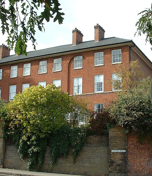
パーク エステートは、ノッティンガム城のすぐ西に位置する森林に覆われた鹿公園として誕生しました。1087 年の建設から 1663 年まで、この城は王城であり、隣接する公園も王立公園でした。公園には鹿のほかに、魚のいる池やウサギの巣穴があり、また「狩りに熱中していた」と伝えられるヘンリー 2 世は鷹狩りも行いました。公園は城の住人に食料とスポーツの両方を提供していたでしょう。イングランド内戦中に議会軍が城を占領した後、公園の木々は駐屯軍に燃料と物資を供給するために伐採され、1651 年に城は破壊されました。[2] [3]
1663年、廃墟となった城と公園はニューカッスル公爵ウィリアム・キャベンディッシュに買収された。キャベンディッシュは当初、公園に鹿を放牧したが、1720年代までにこの地域は牛の放牧地になっていた。1800年、ニューカッスル公爵ヘンリー・ペラム=クリントンが未成年だった頃、彼の母親は公園の売却を検討した。彼女の代理人は、ノッティンガムの地価が下がると考えたため、そのような売却はやめて、代わりに公園周辺の小さな区画を徐々に売却することを勧めた。公園内の最初の住宅は1809年に建てられた。城の門番所の向かいに建てられたこの建物は、セント・メアリー教会の牧師館として使われた。[3] [4] [5] [6]
19 世紀にノッティンガムが産業化されると、公園は地元の人々にとって貴重なオープン スペースになりました。それにもかかわらず、またその地域を公有地とみなす地元住民からの強い反対があったにもかかわらず、1822 年に第 4 代公爵の統治下で大規模な開発が始まりました。当初は建築家のジョン ジェフソンを雇いましたが、1825 年にジェフソンはピーター フレデリック ロビンソンに交代し、ロビンソンは 1827 年に公園の設計図を発表しました。パーク テラスに最初の家が建てられたのは 1829 年頃で、1832 年までに 40~50 軒ほどが完成しました。このような開発にもかかわらず、1849 年の「ストレンジャーズ ガイド」は、公園は「一般に公開されており、あらゆる階層の人々が散歩道として利用しており、人口が多く密集した町にとって非常に健康的な付属物である」と記しています。[4] [7]
開発は第5代公爵の治世下でも続けられ、1854年に建築家トーマス・チェンバース・ハインが多くの家屋の設計を任され、1859年までにキャッスル・グローブ、レントン・ロード、ニューキャッスル・ドライブ、クリントン・テラスの家屋が完成した。1864年に第5代公爵が死去した後も、ハインは引き続きこの地所の建築家を務め、このとき地所は信託によって管理されていた。大きな別荘の多くは地元の裕福な産業家や実業家のために建てられ、彼らは独自の建築家を雇っていた。1891年に引退するまで、すべての家屋の設計はハインの承認が必要だった。ハインは、ダービー・ロードへの馬車のアクセスを提供することを目的としたパーク・トンネルの建設も担当した。 [8] [9]
1918年までに、この地所は355軒の家屋でほぼ完成しました。1930年代半ばまでに、より大きな家屋は売却が困難であることが判明しました。残っている賃貸契約の多くは非常に短期でした。初代トレント男爵ジェシー・ブートの旧邸宅であるセント・ヘリアーズは、10年間空き家となっていて、良好な状態であると報告されていましたが、1932年6月15日にウォーカー、ウォルトン、ハンソンによって競売にかけられました。当初の費用は約6,000ポンドでしたが、ウィルフォードの下請け建築業者のハーバート・ウェイトマンが7ポンドでこの物件を購入しました[10](2023年の614ポンドに相当)。[11]ニューカッスル地所に支払われる地代は年間116ポンド(2023年の10,171ポンドに相当)でした。[11]取り壊しを禁止する協定があったと思われていたが、1936年に取り壊された。[12]
1938年、第8代公爵は公園をナッフィールド・トラストに売却し、ナッフィールド・トラストはそれをオックスフォード大学に売却した。1940年から1986年にかけて、オックスフォード大学は所有者に自由保有権を売却した。公園は1969年に保護地域に指定された。1986年、公園居住者協会とオックスフォード大学基金との交渉の結果、敷地の所有権は新しく設立された会社、ノッティンガム・パーク・エステート・リミテッドに移管された。[13]
2007年までに、1918年以前に建てられた355軒のオリジナルの家屋のうち、約12軒を除いてすべてがまだ残っており、その多くは外観に大きな変更が加えられていない。[7]
建築
次の表は、公園敷地内の重要な資産をリストしたものです。
計画上の制約
公園は保護地区であり、多くの建物が登録されています。計画の提出には詳細な計画規制が適用されます。
住宅地
アクセス
敷地内への車両の進入は、ノースロード(ダービーロードから)、レントンロード(城の隣)、ペヴェリルドライブ(キャッスルブールバードから)の3つの入口に制限されており、これらの入口では、昇降式ボラードを操作するために、敷地内のANPRシステムへの登録が必要です。また、バラックレーン(ダービーロードから)とニューキャッスルドライブ/パークロウ(ロープウォークから)の2つの小さな入口があり、敷地の特定の部分へのアクセスを提供していますが、バラックレーン自体は公園内にはありません。[57] [58]
歩行者/自転車用の入り口はいくつかあり、そのほとんどは門で囲まれており、夜間は施錠されるところもある。これらは、レントン・ロード(レントンのパーク・ロードにつながる)、レントン・ロード(ロック・ドライブの隣:キャッスル・ブールバードにつながる急な歩道)、フィッシュ・ポンド・ドライブ(キャッスル・ブールバードにつながる)、ニューキャッスル・ドライブ(カニング・サーカスから外れたところ)、そしてトンネル・ロードからダービー・ロード(バジェンズ・ストアの近く)まで続くパーク・トンネルで、途中にアッパー・カレッジ・ストリートまでの階段がある。ペルハム・クレセントからレントンのハラクストン・ドライブまで門のある歩道がある。[58]
1999年から2013年まで、レントンのレントンロードとパークロードの間の歩行者用ゲートは、毎晩午後11時から午前5時まで施錠されていた。団地管理者は、この道路は学生の多いレントンと市の中心部を結んでいるため、深夜の騒音と反社会的行動を減らすために必要だと主張した。[要出典] 2013年にレントンロードの法的地位を検討する公開の地方調査が行われ、少なくとも1700年から公道が存在していたため、この道路は公道であり、議会の確定地図に追加されるべきであり、施錠されたゲートで法的に封鎖することはできないという裁定が下された。[59] [60]この結果、レントンロードとパークロードの間のゲートは撤去された。
メンテナンス手配
The Park is a private estate, managed by Nottingham Park Estate Ltd, a company governed by Act of Parliament.[13] Living on the estate incurs both council tax and a local charge ('Park Rates'). The park rates cover maintenance of roads, pavements, the gas light network, the trees and the public green spaces. Residents previously received a reduced council tax bill due to these rates covering services which would usually provided by the council. However, the Park Estate rate is now paid in addition to the full council tax rate.[citation needed]
Residents' Association
The Nottingham Park Residents' Association (NPRA) holds regular talks and hosts a number of events using the two green spaces in the middle of the estate. They also produce a twice yearly magazine which is delivered, free of charge, to every Park household.[61]
In 2011 the NPRA hosted a street party on the day of the Royal Wedding, and, in 2012, a Diamond Jubilee Street Party. Other events include a picnic for young children based on the Teddy Bear picnic song, a Carol Service and Boule tournament. Every two years in June a number of the gardens are open to the public, with the proceeds being donated to local charities.[62]
Neighbouring areas
- Lenton to the West
- Radford to the North
- Nottingham City Centre to the East
References
- ^ "2001 Census – The Park Community Profile". City of Nottingham. Archived from the original on 8 January 2018.
- ^ "Nottingham Park: From Ducal Estate to Urban Residence". Manuscripts and Special Collections. University of Nottingham. Archived from the original on 29 May 2019. Retrieved 29 May 2019.
- ^ a b "The Park – a Medieval Inheritance". Manuscripts and Special Collections. University of Nottingham. Archived from the original on 30 May 2019. Retrieved 30 May 2019.
- ^ a b "The Park and its Purpose". Manuscripts and Special Collections. University of Nottingham. Archived from the original on 30 May 2019. Retrieved 30 May 2019.
- ^ "Speculations and Proposals". Manuscripts and Special Collections. University of Nottingham. Archived from the original on 30 May 2019. Retrieved 30 May 2019.
- ^ St. Mary's Parish Statement. St. Mary's PCC. 2003
- ^ a b Alan Mulcahy (2007). A Conservation Plan for the Park Estate (PDF) (Report). Nottingham City Council. Archived (PDF) from the original on 4 October 2012. Retrieved 19 April 2017.
- ^ "A Brief History of the Nottingham Park Estate". The Nottingham Park Estate Limited. Archived from the original on 6 January 2017. Retrieved 5 January 2017.
- ^ "T C Hine and the Park Tunnel". Manuscripts and Special Collections. University of Nottingham. Archived from the original on 29 May 2019. Retrieved 29 May 2019.
- ^ "£6,000 house for £7". Nottingham Evening Post. England. 16 June 1932. Retrieved 24 April 2017 – via British Newspaper Archive.
- ^ a b UK Retail Price Index inflation figures are based on data from Clark, Gregory (2017). "The Annual RPI and Average Earnings for Britain, 1209 to Present (New Series)". MeasuringWorth. Retrieved 7 May 2024.
- ^ "The Lighter Side". Nottingham Evening Post. England. 7 September 1936. Retrieved 27 April 2017 – via British Newspaper Archive.
- ^ a b "Nottingham Park Estate Act 1990" (PDF). www.legislation.gov.uk. 1990.
- ^ a b Historic England. "62 and 64, Castle Boulevard (1246305)". National Heritage List for England. Retrieved 18 April 2017.
- ^ a b Historic England. "1 and 2, Castle Grove (1246754)". National Heritage List for England. Retrieved 18 April 2017.
- ^ Historic England. "3, Castle Grove (1271165)". National Heritage List for England. Retrieved 18 April 2017.
- ^ Historic England. "5, Castle Grove (1246811)". National Heritage List for England. Retrieved 18 April 2017.
- ^ Historic England. "Number 7 and attached archway (1271187)". National Heritage List for England. Retrieved 18 April 2017.
- ^ Historic England. "Peveril Tower and attached gateway (1246775)". National Heritage List for England. Retrieved 18 April 2017.
- ^ Historic England. "Park House (1247106)". National Heritage List for England. Retrieved 18 April 2017.
- ^ a b c d e f g h i j k l m n o p q r s t u v w x y z aa ab ac ad ae af ag ah ai aj ak al am an ao ap aq ar Harwood, Elain (2008). Pevsner Architectural Guides. Nottingham. Yale University Press. ISBN 9780300126662.
- ^ a b c d e f g h i j k Brand, Ken (2003). Thomas Chambers Hine. Architect of Victoria Nottingham. Nottingham Civic Society. ISBN 190244308X.
- ^ a b c d e f g h i j k l Turner, Darren (2012). Fothergill. A Catalogue of the Works of Watson Fothergill, Architect. Darren Turner.
- ^ a b Historic England. "Numbers 3 and 4 and attached external corridors (1270776)". National Heritage List for England. Retrieved 18 April 2017.
- ^ a b Historic England. "Castle Rising (3) and attached area railings (1270736)". National Heritage List for England. Retrieved 18 April 2017.
- ^ Historic England. "Castle Bank and attached boundary wall (1254545)". National Heritage List for England. Retrieved 18 April 2017.
- ^ Historic England. "Fothergill House and attached boundary wall (1270678)". National Heritage List for England. Retrieved 18 April 2017.
- ^ Historic England. "Park Estate Office (1254546)". National Heritage List for England. Retrieved 18 April 2017.
- ^ Historic England. "Melvell House and attached Stable Block (1254792)". National Heritage List for England. Retrieved 18 April 2017.
- ^ Pevsner, Nikolaus; Williamson, Elizabeth; Hartwell, Clare (2020). The Buildings of England. Nottinghamshire. Yale University Press. p. 449. ISBN 9780300247831.
- ^ Historic England. "Walton House and attached boundary wall and lych gate (1254837)". National Heritage List for England. Retrieved 18 April 2017.
- ^ Historic England. "East Lodge (1270628)". National Heritage List for England. Retrieved 18 April 2017.
- ^ Historic England. "Tower House (1254871)". National Heritage List for England. Retrieved 18 April 2017.
- ^ a b Historic England. "1 and 2 and attached area railings (1254800)". National Heritage List for England. Retrieved 18 April 2017.
- ^ a b Historic England. "3 and 4 and attached area railings (1270567)". National Heritage List for England. Retrieved 18 April 2017.
- ^ a b Historic England. "5 and 6 and attached area railings (1270629)". National Heritage List for England. Retrieved 18 April 2017.
- ^ a b Historic England. "7 and 8 and attached area railings (1254902)". National Heritage List for England. Retrieved 18 April 2017.
- ^ a b Historic England. "9 and 10 and attached area railings (1254905)". National Heritage List for England. Retrieved 18 April 2017.
- ^ a b Historic England. "11 and 12, Park Terrace (1254906)". National Heritage List for England. Retrieved 18 April 2017.
- ^ a b c Historic England. "Numbers 15, 16 and 17 and attached railings and gateways (1059024)". National Heritage List for England. Retrieved 18 April 2017.
- ^ Historic England. "Numbers 18, 19 and 20, and attached railings and retaining wall to Park Tunnel (1246305)". National Heritage List for England. Retrieved 18 April 2017.
- ^ Historic England. "Number 7 and attached boundary wall (1344949)". National Heritage List for England. Retrieved 18 April 2017.
- ^ a b Historic England. "8 and 10, Park Valley (1059026)". National Heritage List for England. Retrieved 5 February 2019.
- ^ Historic England. "Number 15 and attached area railings (1059027)". National Heritage List for England. Retrieved 18 April 2017.
- ^ a b Historic England. "Numbers 17 and 19 and attached area railings (1344950)". National Heritage List for England. Retrieved 18 April 2017.
- ^ a b Historic England. "Numbers 21 and 23 and attached area Balustrades and Gate Piers (1059028)". National Heritage List for England. Retrieved 18 April 2017.
- ^ Historic England. "Number 25 and attached Boundary Walls (1344951)". National Heritage List for England. Retrieved 18 April 2017.
- ^ Historic England. "32 and 32A, The Ropewalk (1270466)". National Heritage List for England. Retrieved 24 April 2017.
- ^ Historic England. "34, Ropewalk (1254994)". National Heritage List for England. Retrieved 24 April 2017.
- ^ a b Historic England. "36, 37 and 38, Ropewalk (1254995)". National Heritage List for England. Retrieved 24 April 2017.
- ^ Historic England. "40, Ropewalk (1254996)". National Heritage List for England. Retrieved 24 April 2017.
- ^ Historic England. "Number 1 and attached boundary wall (1255170)". National Heritage List for England. Retrieved 18 April 2017.
- ^ Historic England. "3 South Road (1255212)". National Heritage List for England. Retrieved 18 April 2017.
- ^ a b Historic England. "Numbers 3 and 4 and attached railings and wall (1255254)". National Heritage List for England. Retrieved 18 April 2017.
- ^ a b Historic England. "Numbers 5 and 6 and attached boundary wall (1255255)". National Heritage List for England. Retrieved 18 April 2017.
- ^ a b c d Historic England. "7 to 10, Western Terrace (1255256)". National Heritage List for England. Retrieved 18 April 2017.
- ^ "The Nottingham Park Estate Limited :: Parking and Access". www.thenottinghamparkestateltd.co.uk. Retrieved 15 April 2022.
- ^ a b "The Park Conservation Plan" (PDF).
- ^ Norton, Tom (2013年7月26日). 「公聴会終了後、住民はパークの判決を待っている」. Nottingham Evening Post . 2013年7月29日時点のオリジナルよりアーカイブ。 2013年7月30日閲覧。
- ^ Michael Lowe (2013年11月20日). 「命令決定、2013年7月23日に調査開始」(PDF)。都市計画検査局。2015年6月12日時点のオリジナル(PDF)よりアーカイブ。
- ^ 「ParkNews – ノッティンガムパーク住民協会のウェブサイト」。parknews.co.uk 。2017年1月5日閲覧。
- ^ 「The Park Garden Trail」. parkgardentrail.co.uk . 2018年4月4日閲覧。
文献
- ケン・ブランド著『The Park Estate, Nottingham』。ノッティンガム市民協会の「ノッティンガムを知る」シリーズの一部として出版されました。
- フォザーギル: 建築家ワトソン・フォザーギルの作品カタログ、ダレン・ターナー著。DT:P 2012年出版。
外部リンク

ウィキメディア・コモンズには、ノッティンガムのパーク・エステートに関連するメディアがあります。
- http://www.thenottinghamparkestateltd.co.uk
- http://www.parknews.co.uk
- http://www.nottinghamcity.gov.uk/cdpl-park-ca-plan.pdf