
Loading article…
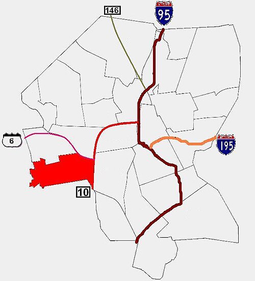
Silver Lake is a neighborhood on the western edge of Providence, Rhode Island. It is bordered by the Hartford neighborhood to the north, Route 10 to the east, Johnston and Cranston on the West and separated from Olneyville by Route 6.
Like Federal Hill, Silver Lake was traditionally an Italian-American neighborhood. Since the mid-1990s, Silver Lake has undergone a radical transformation into a largely Hispanic neighborhood, as evidenced by the recent influx of Central American restaurants, bars and markets.
Settlement in Silver Lake began after the completion of the Plainfield Road to Plainfield, Connecticut in 1710. Farmers settled the area shortly afterward. Isolated from the rest of Providence, some sought to secede from Providence before the town of Johnston, Rhode Islandannexed Silver Lake in 1759.[1]
Silver Lake took its name from the original approximately ten acre lake located in the area bordered by Murray, Sybil, Mercy and Plainfield Streets. At the turn of the 20th century, it was graded with landfill and debris then became the site of a supermarket and bank for many years.
Suburban development in the 19th century led Providence to reacquire Silver Lake in 1898. Shortly thereafter, Silver Lake witnessed its most significant period of development in the early 20th century prior to the Great Depression.[1] From the late 19th century until the 1970s the neighborhood was predominately Italian with Irish, Polish, English and a mix of other European immigrants.
In 1990, nearly 43% of Silver Lake residents claimed some Italian ancestry. That same census showed that about 7% of Silver Lake's residents Hispanic, 2.3% were Asian, and 2% were African-American. Median family income in Silver Lake was $27,736, about 2% lower than the citywide average. 16% of families lived in poverty.[1]
According to the 2000 census, 10,943 persons resided in Silver Lake, an increase from the 9,141 residents who called Silver Lake home in 1990. Between 1990 and 2000 the percentage of non-white residents in Silver Lake rose from 11 percent to 57.6 percent. 42 percent of Silver Lake's residents were Hispanic; 42% were White; 3.7 percent were Asian; and 8 percent were African-American. In 2000, more than half (58%) of the residents of age 25 or older were high school graduates. 59% of children under the age of six speak a language other than English as their primary language.[2]
Housing tenure in Silver Lake has remained mostly unchanged over the past decade. The proportion of owner-occupied housing units declined slightly from 36.6 percent to 35 percent between 1990 and 2000. About a fifth of all housing units in Silver Lake are single-family units, and most other structures house two to four families. 8 percent of all housing units in Silver Lake are located in buildings with five or more housing units, reflecting the more suburban character of much of the neighborhood.
The median family income was $27,981, below the citywide average of $32,058. 28% of families were below the poverty level while 15% receive some form of public assistance. 18% of children under the age of six had been exposed to high levels of lead.[2]
Over half of Silver Lake is within Ward 7, which is represented in the Providence City Council by Democrat Ana Vargas.[3] The eastern portion of Silver Lake is within Ward 15, represented by Democrat Oscar Vargas.[4] Ward 15 was formerly represented by the current Rhode Island Lieutenant Governor Sabina Matos, the first Dominican-American elected to statewide office in the United States as well as the first Black statewide officeholder in Rhode Island.


Neutaconkanut Park (NEW-tah-kon-kuh-nut or NEW-tah-kon-uh-kut[5]) occupies most of Silver Lake between Plainfield Street and the border with Johnston. It is a 73-acre (300,000 m2) park with baseball fields, basketball courts, public pool and recreation center as well as forest and walking trails.[6]
公園内には、市内最高地点である標高296フィートのニュータコンカナット・ヒルがある。[ 7 ]この丘は、ロジャー・ウィリアムズとナラガンセット族の酋長カノニカスとミアントノミとの合意により、プロビデンスの北西の境界線となった。[ 7 ]かつてこの丘には巨大な氷河性迷子石が立っており、カノニカスの見張り台として使われていたと考えられている。[ 7 ]近隣住民が岩が丘から転がり落ちてくることを恐れたため、岩は砕かれた。[ 7 ]作家ヘンリー・デイヴィッド・ソローは 、1854年にプロビデンスを訪れた際に、ニュータコンカナット・ヒルに登ったことを日記に記している。 [ 7 ]
シルバーレイク通りとポカセット通りの交差点付近には、4つの小さな記念公園があります。それらは以下の通りです。
シルバーレイクでは、聖バルトロマイ祭が開催されます。この教会のお祭りでは、厳粛な行列のほか、ゲーム、アトラクション、イタリア系アメリカ料理とヒスパニック料理など、様々な料理が楽しめます。お祭りは3日間続き、毎年8月に開催されます。
1907年、初代聖バルトロマイ教会(当時はムーアフィールド通りにあった)が献堂されました。この教会は、近隣に住むイタリア移民によって建てられました。彼らの多くは、シルバーレイクに定住する前は、南イタリアのカンパニア州カゼルタ県ヴァイラーノ・パテノーラに住んでいました。教会の名前は、ヴァイラーノ・パテノーラにある聖バルトロマイ教区(La Parrochia di San Bartolomeo)にちなんで名付けられました。年月を経て教区の規模は大きく拡大したため、1969年には、ローレルヒル通りの教区学校の隣に、より大きく新しい教会が建てられました。
41°48′39″N71°27′15″W / 41.8109°N 71.4542°W / 41.8109; -71.4542