
Loading article…
バーンズビルは、アメリカ合衆国オハイオ州ベルモント郡にある村です。ウォーレン郡区の中央部に位置しています。 2020年の国勢調査によると、人口は4,008人でした。バーンズビルは、ウィーリング都市圏の一部です。
この町は最初の入植者であるジェームズ・バーンズにちなんで名付けられました。[ 6 ]バーンズはメリーランド州モンゴメリー郡で生まれ、「聡明なクエーカー教徒の女性」ナンシー・ハリソンと結婚しました。バーンズはモンゴメリー郡に農場を所有し、後にそこにバーンズビル(メリーランド州)としても知られる町を建設し、しばらくの間、田舎の雑貨店を経営しました。
1803年、彼はオハイオ州セントクレアズビルに移り住み、そこで酒場と雑貨店を経営した。1806年、バーンズはベルモント郡ウォーレン郡区に定住し、森林を開墾し、家を建て、製革所と雑貨店を設立し、果樹園を植えた。1808年11月、バーンズビルの町が区画整理され、4年後、バーンズとその家族は新しい村の永住者となった。[ 7 ] 1833年のバーンズビルには6軒の商店と蒸気製粉所があったと記されている。[ 8 ]
バーンズビルは1835年に村として法人化された。[ 9 ]
米国国勢調査局によると、この村の総面積は1.95平方マイル(5.05 km 2 )で、そのうち1.94平方マイル(5.02 km 2 )が陸地、0.01平方マイル(0.03 km 2 )が水域である。[ 10 ]
As of the 2020 census, Barnesville had a population of 4,008. The median age was 41.0 years. 23.3% of residents were under the age of 18 and 21.9% of residents were 65 years of age or older. For every 100 females there were 86.7 males, and for every 100 females age 18 and over there were 81.2 males age 18 and over.[15][16]
0.0% of residents lived in urban areas, while 100.0% lived in rural areas.[17]
There were 1,715 households in Barnesville, of which 28.7% had children under the age of 18 living in them. Of all households, 38.0% were married-couple households, 19.0% were households with a male householder and no spouse or partner present, and 35.7% were households with a female householder and no spouse or partner present. About 36.3% of all households were made up of individuals and 18.1% had someone living alone who was 65 years of age or older.[15]
There were 1,977 housing units, of which 13.3% were vacant. The homeowner vacancy rate was 3.2% and the rental vacancy rate was 8.4%.[15]
As of the census[18] of 2010, there were 4,193 people, 1,763 households, and 1,114 families living in the village. The population density was 2,161.3 inhabitants per square mile (834.5/km2). There were 2,011 housing units at an average density of 1,036.6 per square mile (400.2/km2). The racial makeup of the village was 97.0% White, 0.9% African American, 0.1% Native American, 0.3% Asian, and 1.6% from two or more races. Hispanic or Latino of any race were 0.6% of the population.
There were 1,763 households, of which 29.4% had children under the age of 18 living with them, 42.4% were married couples living together, 15.7% had a female householder with no husband present, 5.1% had a male householder with no wife present, and 36.8% were non-families. 32.0% of all households were made up of individuals, and 16.3% had someone living alone who was 65 years of age or older. The average household size was 2.28 and the average family size was 2.82.
The median age in the village was 41.4 years. 21.4% of residents were under the age of 18; 8.9% were between the ages of 18 and 24; 23.9% were from 25 to 44; 25.5% were from 45 to 64; and 20.5% were 65 years of age or older. The gender makeup of the village was 46.2% male and 53.8% female.
As of the census[5] of 2000, there were 4,225 people, 1,769 households, and 1,119 families living in the village. The population density was 2,196.6 inhabitants per square mile (848.1/km2). There were 1,964 housing units at an average density of 1,021.1 per square mile (394.2/km2). The racial makeup of the village was 98.41% White, 0.71% African American, 0.07% Native American, 0.17% Asian, and 0.64% from two or more races. Hispanic or Latino of any race were 0.26% of the population.
There were 1,769 households, out of which 28.9% had children under the age of 18 living with them, 45.5% were married couples living together, 13.9% had a female householder with no husband present, and 36.7% were non-families. 33.7% of all households were made up of individuals, and 18.5% had someone living alone who was 65 years of age or older. The average household size was 2.30 and the average family size was 2.94.
In the village, the population was spread out, with 23.6% under the age of 18, 8.3% from 18 to 24, 25.5% from 25 to 44, 21.7% from 45 to 64, and 20.8% who were 65 years of age or older. The median age was 40 years. For every 100 females, there were 82.0 males. For every 100 females age 18 and over, there were 77.4 males.
The median income for a household in the village was $23,925, and the median income for a family was $31,927. Males had a median income of $25,098 versus $16,119 for females. The per capita income for the village was $14,105. About 21.2% of families and 22.1% of the population were below the poverty line, including 35.1% of those under age 18 and 14.6% of those age 65 or over.

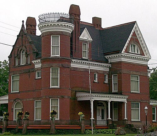
The Belmont County Victorian Mansion Museum is located in Barnesville. The museum includes twenty-six rooms restored to the Victorian era.[19]
The village is the host of the Barnesville Pumpkin Festival every September, attracting tourists from the area.
The Watt Center for History and the Arts is located in Barnesville.[20] The original office building of the Watt Car and Wheel Company now contains exhibits about coal history and area business, industry, and agriculture. The Watt Car and Wheel Company was founded in 1862 as the Joseph Watt and Son foundry.
The Village of Barnesville’s legislative body consists of a six-member council. Members are elected officials and serve a four-year term.[21]
The village of Barnesville is served by the Barnesville Exempted Village School District. The village's schools saw a renovation in 2002 to improve and expand classroom learning and appearances.
There are three main schools in the village: Barnesville Elementary School, Barnesville Middle School, and Barnesville High School.
Also located in the village is Olney Friends School, a small co-educational boarding high school affiliated with the Religious Society of Friends (Quakers).
The Barnesville-Bradfield Airport is located one nautical mile (1.2 mi; 1.9 km) northwest of Barnesville's central business district.[22]


{{cite web}}: CS1 maint: bot: original URL status unknown (link) Barnesville travel guide from Wikivoyage