
Loading article…
 South Carolina Highway 768 | ||||
|---|---|---|---|---|
 | ||||
| Route information | ||||
| Maintained by SCDOT | ||||
| Length | 4.880 mi[1] (7.854 km) | |||
| Existed | 1982–present | |||
| Major junctions | ||||
| West end |  SC 48 in Columbia SC 48 in Columbia | |||
| Major intersections |  I-77 in Columbia I-77 in Columbia | |||
| East end |   US 76 / US 378 near Columbia US 76 / US 378 near Columbia | |||
| Location | ||||
| Country | United States | |||
| State | South Carolina | |||
| Counties | Richland | |||
| Highway system | ||||
| ||||
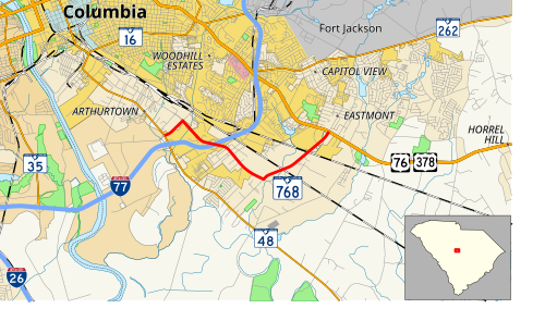
South Carolina Highway 768 (SC 768) is a 4.880-mile (7.854 km) primary state highway in the U.S. state of South Carolina. It serves to connect businesses along Shop Road to nearby state highways.

SC 768 is an urban highway that zig-zags from SC 48 to U.S. Route 76 (US 76) and 378. The main stretch is Shop Road, where it is a four-lane divided highway and has an interchange with Interstate 77 (I-77); while Beltline Boulevard and Pineview Road are a two-lane with a median.[2]
The first SC 768 appeared from 1942-1948 as a spur off US 76, from Marion4 miles (6.4 km) to Pitch Pot Swamp. It was downgraded to secondary status.
The current SC 768 was established between 1980–82, as a new primary routing; which has changed little since.
The entire route is in Richland County.
 South Carolina Highway 768 Connector | |
|---|---|
| Location | Columbia, South Carolina |
| Length | 1.059 mi[3] (1.704 km) |
South Carolina Highway 768 Connector (SC 768 Conn.) is a connector route of SC 768 between the mainline (Shop Road / Pineview Road) and Longwood Road, south-southeast of Columbia.[4] It is known as Shop Road Extension and is an unsigned highway.[5]
 U.S. roadsportal
 ウィキメディア・コモンズにあるサウスカロライナ州道768号線関連のメディア
