
Loading article…
San Martín (Spanish pronunciation:[sammaɾˈtin]) is a department of Peru. Located in the country's north, most of the department is located in the upper part of the Peruvian Amazon rainforest. It is administered by a regional government. Its capital is Moyobamba and the largest city in the department is Tarapoto.
The territory of San Martín can be divided into four morphological zones:
The Huallaga River is one of the most important rivers in the region. It forms, together with its tributaries a hydrographical system which drains all of the region's territory. The Pongo de Aguirre is an important canyon formed by the Huallaga going through the Andean hills.

In San Martín, Conservation International Peru lists an office in Rioja and leads the Alto Mayo Protected Forest Conservation Initiative in the Alto Mayo Protection Forest.[1][2]
トゥパック・ユパンキは、当時現地名でムユパンパと呼ばれていたモヨバンバ州、インカ帝国の領土に侵入し、これを征服した。1539年、スペイン人のアロンソ・デ・アルバラードはマヨ川に到達し、サンティアゴ・デ・ロス・バジェス・デ・モヨバンバと名付けた都市を建設した。この都市は後にマイナスの首都となった。もう一人重要な人物は、1787年から1790年の間にワジャガ川を横断し、その後「ワジャガ川とウカヤリ川の流路とパンパ・デル・サクラメントの計画」という地図を出版したマヌエル・ソブレビエラ神父である。
1821年8月19日、モヨバンバはペルーで最初に独立を宣言した都市となった。
近年の高速道路建設により、様々な商品の流通が増加し、この地域の経済に恩恵をもたらしている。
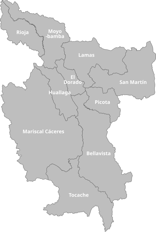
この地域は 10 の州(スペイン語: provincias、単数形: provincia )に分かれており、78 の地区( distritos、単数形: distrito ) で構成されています。
各州(括弧内は州都)は以下のとおりです。
グラン・パハテンは、ラ・リベルタとの境界に位置する、円形の粘板岩造りの建造物群からなるプレ・インカ時代の遺跡で、飛翔するコンドルの像が装飾されている。アクセスが困難なため、現時点では観光は許可されていない。