
Loading article…


Cap Gris-Nez is a cape located in Audinghen, a commune in the Pas-de-Calais département of northern France. Part of the Côte d'Opale, it is classified as a protected natural area. Its cliffs mark the closest point of France to Great Britain, separated by just 34 km (21 mi).
The name "Gris-Nez" translates to "grey nose" in French referencing the grey-coloured cliffs of the cape. The Dutch name, "Swartenesse" ("black cape"), distinguished it from "Blankenesse" ("white cape"), now known as Cap Blanc-Nez to the northeast. The suffix "-nesse" or "-nez" is cognate with the English "-ness," signifying a headland, as seen in Dungeness and Sheerness.
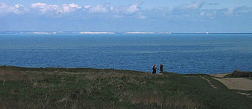
The cliffs of Cap Gris-Nez are composed of sandstone, clay, and chalk, primarily grey in colour. The area is a site for fossil hunting, with most fossils originating from the Jurassic period. These include bivalves, gastropods, and fossilised wood. Rare finds, such as large ammonites, as well as fish and reptile teeth, are occasionally uncovered in the sandstone layers containing small pebbles.[1]
The cape is a migration bottleneck, providing a vantage point for observing birds migrating across the English Channel or along the coastline.[2]
The proximity of the cape to England resulted in the frequent destruction of the nearby village of Audinghen in wars between England and France. On the top of the cliff are the ruins of an English fortress, built by Henry VIII at the beginning of the 16th century. The English called the fort 'Blackness', a translation of the Dutch name Swartenisse.[3]
On July 1, 1803, Napoleon stopped at Cape Gris-Nez whilst inspecting the coast around Boulogne-sur-Mer with his invasion troops. He envisioned establishing a cross-channel optical telegraph system, with a semaphore positioned on the cape. The first semaphore of this line was installed in 1805, even before the planned French invasion of England took place.
1805年7月18日、ブランネ岬とグリネ岬の海戦が起こった。この海戦では、数で勝るイギリス艦隊が、海岸沿いにアンブルトゥーズ港を目指していたオランダ艦隊を追撃した。ナポレオンはこの種の攻撃を予期し、岬に300門の大砲を配置していた。この砲撃により、イギリス艦隊は撤退を余儀なくされた。
ガブリエル・オーギュスト・フェルディナン・デュクインとその部下は、1940年5月25日、信号所を防衛中に戦死した。彼らの犠牲を称えるため、後に岬に記念碑が建てられた。その後、ドイツ軍はチューダー朝時代の遺跡の中にトーチカを建設した。この地域には、連合軍の侵攻を阻止するために建設された大西洋の壁の一部である第二次世界大戦時の掩蔽壕群がある。2つの重砲陣地があり、かつては170mm砲3門を擁していたグローサー・クルフュルスト砲台と、 380mm砲4門を擁していたトッド砲台である。これらの砲台はカレーとブローニュの両方への接近路をカバーしており、大型のコンクリート製トーチカやその他の小規模な防御施設によって守られていた。トッド砲台のトーチカの1つは現在、大西洋の壁博物館となっている。
カナダ第3歩兵師団の部隊は、1944年9月にこの地域を解放した。
グリ・ネ岬にある現在の円筒形のコンクリート灯台は1958年に建設され、戦争中に破壊された以前の構造物に取って代わりました。高さ31メートル(102フィート)のこの灯台とそれに付随するレーダー施設は、毎日岬を通過する500隻以上の船舶に航行の指針を提供しています。[ 4 ]
北緯50度52分15秒、東経1度35分01秒/北緯50.87083度、東経1.58361度/北緯50.87083度、東経1.58361度