
Loading article…
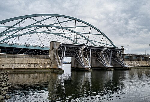

フォックスポイント・ハリケーン防潮堤は、ロードアイランド州プロビデンスのプロビデンス川に架かる全長3,000フィート(910メートル)の高潮防潮堤で、フォックスポイントから上流750フィート(230メートル)の地点に位置しています。1960年から1966年にかけて建設され、ハリケーンやその他の大規模な暴風雨に伴う高潮や洪水による被害から、市の低地にあるダウンタウン地域を守ることを目的としています。
フォックスポイントハリケーンバリアは、主に5つの部分から構成されています。河川ゲート、両岸に沿った岩と土の堤防、道路が堤防を横切る両岸に沿った車両ゲート、近くの発電所に関連するバリアの西端にある運河ゲート、そして水の流れを制御するためのポンプ場です。 [ 1 ]
植民地時代から、ナラガンセット湾の奥に位置するプロビデンス港は、市の経済にとって不可欠な存在でした。外洋航行船は、ダウンタウンのすぐ南にあるウォーターフロントに定期的に停泊しています。19世紀には、プロビデンスは工業生産と貿易において全米をリードする都市となりました。ダウンタウンは、平均海面からわずか8~12フィート(2.4~3.7メートル)の浅い自然の盆地に位置しています。
1938年9月、ニューイングランド大ハリケーンがニューイングランド南部沿岸を襲い、この地域で250人が死亡、数百万ドルの被害をもたらした。活気あふれる商業の中心地であったプロビデンスのダウンタウンは完全に水没し、市内だけで約1億2000万ドルの被害が出た。
1954年にも、この地域はハリケーン・キャロルに見舞われ、平均海面より14.4フィートも高い高潮が発生し、プロビデンス中心部の一部では水位が8フィート(2.4メートル)にも達し、4100万ドル以上の被害が出た。[ 2 ]
地方、州、連邦の当局は、将来の壊滅的な被害を防ぐために行動を起こすことを決定した。防潮堤の建設は、1958年に治水法に基づいて認可された。[ 3 ]
The $16 million wall has never seen a Category 5 hurricane, but has successfully protected the city in every instance since its construction.[4]
Constructed between 1960 and 1966 at a cost of $14 million, the barrier was the first of its type to be approved for construction in the United States.[5]
The main feature of the hurricane barrier is a group of three large movable gates which span the river, allowing boats to pass through during normal periods. Each of the three Tainter gates is 40 feet (12 m) wide and weighs 53 tons with a curved outer portion facing the tide. It takes about 30 minutes to lower each gate.[6] The relatively narrow gates prohibit large ships from passing into the inner downtown harbor as they did in the 19th century. However, modern ocean-going vessels now dock at the Port of Providence, located south of the barrier. The inner harbor is now generally occupied by only small pleasure craft during the summer months.
The majority of the hurricane barrier's length consists of a 25-foot (7.6 m) high rock and earthen dike along the low-lying areas of the waterfront within the Fox Point and Jewelry District neighborhoods of Providence. The original dike located along the eastern shore has been removed and replaced with vertical concrete walls as part of the construction of the new embankment for the Interstate 195 relocation.
Three sets of huge steel vehicular gates are located under the newly constructed portion of Interstate 195, east of the Providence River Bridge, at South Water, South Main and at Benefit Street. On the west shore, vehicular gates are located at Allens Avenue as well as on the property of the Manchester Street Power Plant. The gates are normally in the "open" position to allow traffic to pass through, but are closed to provide a continuous barrier during emergency events.
On the west side of the river, there are also two large canal gates, which control water used to cool the nearby Manchester Street Power Station, which is operated by Dominion Resources.[7]

この堰堤には、川の西岸近くに位置するコンクリートとレンガ造りの構造物内にポンプ場も併設されている。ポンプ場には、瞬時に始動可能な4500馬力のポンプが5台設置されており、水門が閉じているときにプロビデンス川の水を堰堤を越えて送水するように設計されている。(そうでなければ、絶えず流れ続ける川の水は行き場を失ってしまう。)
各ポンプの高さは約54.7フィート(16.7メートル) 、直径は約20フィート(6.1メートル)で、合わせて毎分310万ガロン(11,735立方メートル)の水を汲み上げることができる。[ 5 ]
ポンプ場内の計器は、堤防の内側と外側の水位を測定し、ポンプを制御することで、両側の水位をできる限り一定に保つようにしている。
1978年1月10日の強風の際、ゲートが閉鎖されたため、プロビデンスのダウンタウンが2フィートの水に浸かるのを防ぐことができた。[ 8 ]
1985年、フォックスポイントハリケーンバリアが活用され、ハリケーングロリアによる高潮でプロビデンスのダウンタウンが2フィートの水に浸かるのを防ぎ、街を乾いた状態に保った。1991年には、バリアがハリケーンボブから街を守り、ダウンタウンは4フィートの水に覆われるところだった。節約額は数億ドルと推定されており、このプロジェクトは2.21対1の費用対効果比で運営されている。[ 9 ] [ 10 ]
2006年に、この防潮堤の5基の巨大なポンプの300万ドルの改修工事が完了した。[ 7 ]
目撃者によると、2007年4月18日の嵐の際、ハリケーン防波堤のポンプからの水流が、当時博物館として使用されていたソ連の潜水艦K-77の沈没の一因となったと考えられている。[ 11 ]
ハリケーン・アイリーンに備えて、2011年8月28日に防潮堤が閉鎖された。[ 12 ]
ハリケーン・サンディの影響で、2012年10月29日に防潮堤が閉鎖された。水位は9.5フィートに達し、記録上5番目に高い水位となった。[ 13 ]洪水水位は7フィートである。[ 14 ]
熱帯低気圧アンリが到来したため、2021年8月22日の朝に再び防潮堤が閉鎖された。[ 12 ]
この防潮堤は、ウォーターファイア・イベントの開催に役立てるため、干潮時に河川の水位を高く保つ目的でも日常的に使用されている。
北緯41度48分58秒、西経71度24分05秒/北緯41.81601度、西経71.40149度/北緯41.81601度、西経71.40149度